
Effect of dike line adjustment on the tidal bore in the Qiantang Estuary, China*
2017-06-07 08:22JianZeng曾剑GangChen陈刚CunhongPan潘存鸿ZhiyongZhang张芝永ZhejiangInstituteofHydraulicsandEstuaryHangzhou310020China
水动力学研究与进展 B辑 2017年3期
关键词:陈刚
Jian Zeng (曾剑), Gang Chen (陈刚), Cun-hong Pan (潘存鸿), Zhi-yong Zhang (张芝永) Zhejiang Institute of Hydraulics and Estuary, Hangzhou 310020, China
Zhejiang Provincial Key Laboratory of Estuary and Coast, Hangzhou 310020, China,
E-mail: zengjian@zjwater.gov.cn
Effect of dike line adjustment on the tidal bore in the Qiantang Estuary, China*
Jian Zeng (曾剑), Gang Chen (陈刚), Cun-hong Pan (潘存鸿), Zhi-yong Zhang (张芝永) Zhejiang Institute of Hydraulics and Estuary, Hangzhou 310020, China
Zhejiang Provincial Key Laboratory of Estuary and Coast, Hangzhou 310020, China,
E-mail: zengjian@zjwater.gov.cn
2017,29(3):452-459
In this paper, the effect of the dike line adjustment on the Qiantang Tidal Bore (QTB) is studied by physcial experiments. A lab-scale physical model of the Qiantang Estuary is built and the tidal bore is generated. With this model, the formation and pro-pagation processes of the tidal bore are simulated with or without the dike line adjustment. It is shown that the adjusted dike line changes the direction of the reflected tidal bore. The height of the tidal bore increases in the upstream region where the dike line is contracted. In the tested bent and forking regimes, the bore height at the upstream station is increased by 0.10 m and 0.04 m, respectively. Furthermore, the crossing bore still exists near the Daquekou station and the location slightly moves by about 3 km to the downstream region.
Qiantang Estuary, tidal bore, physical model, dike line, land use
Introduction
A tidal bore, with the leading edge of the incoming tide forming water waves, is often generated by a rapid water level rise. It might occur when the tidal water flows into a funnel shape estuary in the opposite direction of the river current. For example, Chanson[1]pointed out that when a tide of a range over 4.5 m-6.0 m flows into a funnel shape estuary which narrows gradually, tidal bores are easy to occur. As many esturaies are trumpet-shaped, tidal bores are common[2,3]. However, the tidal bores in many estuaries are too small to be observed. And to our best knowledge, tidal bores can be observed in the Amazon River in Brazil, the Severn River in the UK[4], the Seine River in France, the Ganges River in India and the Qiantang Estuary in China. Among them, the Qiantang River, the Amazon and Ganges Rvers wit-ness the most famous tidal bores in the world. As a unique natural landscape, the tidal bore has its positive role. Tidal bores attract millions of tourists, which promotes significantly the development of local tourism and improves the local economy. On the other side, tidal bores also have negative effects, such as the brushing of riverbeds and damaging the buildings in and along the river. Therefore, the mechanisms of the occurrence and development of tidal bores are important issues not only for preventing damages caused by tidal bores, but also for protecting this natural landscape.
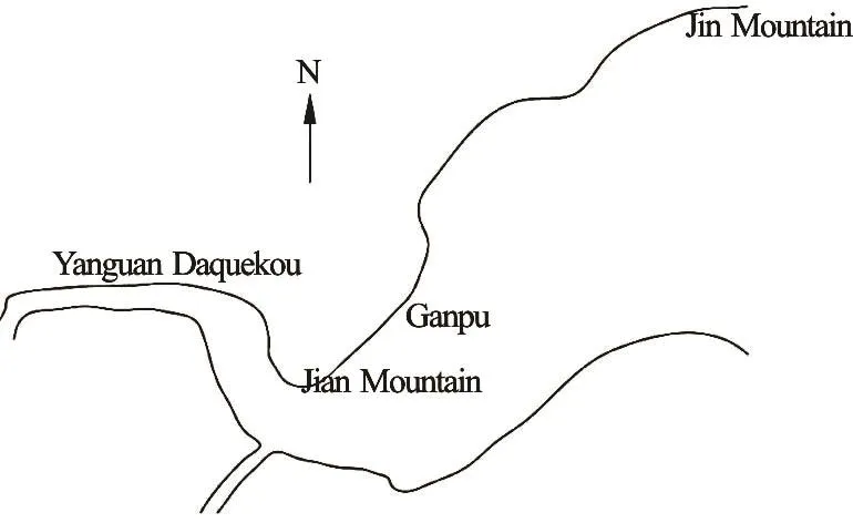
Fig.1 Skecth of the Qiantang Estuary
The Qiantang Estuary (Fig.1) in Zhejiang (China) is an ideal reference site for studying tidal bores asone sees there the largest tidal bore in the world. The Qiantang Tidal Bore (QTB) has a number of different shapes[5], such as the line tidal bore, the reflected tidal bore and the cross tidal bore. The tidal scene attracts millions of tourists each year, that promotes the local economic development and promotes the international reputation of the Hangzhou City in Zhejiang Province. Therefore, protecting the tidal bore is required and is one of the key indicators to evaluate the feasibility of projects along the Qiantang River. With the quick development of economy and the large population in China, the land is increasingly an important resource. In the seaboard near the Qiantang River, reclaiming land from sea is an efficient way to increase the land. However, this kind of projects will change the dike line of the Qiantang River and may influence the tidal bore. Therefore, it is important to study the effect of the dike line adjustment on the tidal bore.
In recent years, various mathematical models were proposed to study the tidal bore[6-11]. However, these models are all based on two-dimensional depthaveraged shallow water equations and can not simulate the three-dimensional hydrodynamic characteristics of the tidal bore. Reichsterter and Chanson[12]and Xu et al.[13]established a three-dimensional numerical model to simulate the tidal bore. However it can only be used to simulate the motion of the tidal bore in a small region and can not be used to simulate the motion of the tidal bore in a field site. The physical model experiment is still an efficient way to study this complex hydraulic process. Chanson[3]conducted laboratory experiments in a water flume and examined the effect of the channel constriction and the bridge piers on the undular tidal bores. Based on the lab-scale results, he found that the bridges narrowed the channel, which caused a potential energy loss of the tidal bore and significantly affected the mixing properties of the tidal bore. Docherty and Chanson[14]used the same regular water flume to study the unsteady turbulence in breaking tidal bores. They found that the velocity fluctuates remarkably and there is an intense secondary motion behind the bore front. Huang et al.[15]developed a new method to generate tidal bores in the rectangular glass flume under various initial flow conditions with respect to the water depths and the ebb velocities before the tidal bore arrives. However, these experimental studies were all conducted using regular water flumes without considerations of the geometry of natural estuaries[16]. As for the practical projects on rivers or estuaries, entity physical model experiments are expected to be better because they are similar to real ones apart from a scale difference. The observed underlying mechanisms are expected in better agreement with reality. An entity physical model of the Qiantang Estuary[17]was established in Zhejiang Institute of Hydraulics and Estuary and was used to study the effect of practical projects on the QTB. In this paper, a dike line adjustment program in the segment from Daquekou to Jian Mountain in the Qiantang Estuary is studied and the effect of the dike line adjustment on the tidal bore is analyzed. Based on the analysis, some suggestions are made in view of practical projects.
1. Overview of the study area
The QTB usually initiates in the river segment of the Gaoyang Mountain, subsequently grows in the upstream and reaches its peak near Daquekou. The tidal bore gradually decays and finally disappears in Wenyan. The tidal bore propagation distance is about 90 km and the maximum tidal bore height is around 3.0 m. For relatively strong tidal bores, the water surface slope is in the range of 1:2.9-1:9.4. The propagation velocity of the leading edge is 4 m/s-7 m/s, and the maximum velocity at observation points is 12 m/s.

Fig.2 Typical river regimes in the Jian Mountain reach
The propagation of the tidal bore is significantly influenced by the river hydrodynamics in the JianMountain segment as shown in Fig.1. The seashore stretch from Ganpu to the Hangzhou Bay is 45.2 km. In this part, the cross section is relatively wide and the sediment transport of the ebb tide to deposit is easy and thus the river bed is considerably variable. Due to the strong reversing flow[5], the main channel swings sometimes and forms three river regimes: the bent, straight and forking regimes, as shown in Fig.2. After frequent flooding, the sediment deposits in the south branch and the water goes through the north branch, to form the straight regime (Fig.2(a)). However, because of the weak hydrodynamics of the backwater region and the sediment deposition in the middle position of the main channel, a forking regime (Fig.2(c)) is formed. During dry seasons, especially during continuous dry years, the tidal regime enhances relatively, so that the main channel swings towards the south direction, meanwhile the north region becomes a high beach to form a bent regime (Fig.2(b)). Over the past decade, under the influence of the reclamation in the north shore near the Jian Mountain and Haining, the main channel tends to move stably towards south instead of north. Even in rainy years, the existing period of the main channel in the north branch is becoming shorter more like a forking regime. With regard to the straight regime, the south branch is silted, and the tidal bore, known as the east tide, spreads towards the west direction along the Haining seawall in the north shore. In the case of the bent regime, the north branch is silted and the south branch stands alone. The tidal bore, known as the south tide, spreads upstream along the south bank of the Xiao Mountain, and the intersected angle between the spreading direction and the Haining seawall is small. As for the forking regime, the river shoal appears in the middle of the river and the main channel is divided into two branches with the tidal bores spreading upstream. When the two tidal bores from different branches meet in the river shoal upstream near Babao and Xincang, the tidal bores cross each other and spread individually, to form a crosstide in the cross-shape or the handstand Y shape. The tidal bore is uniform in the river segment from Babao to Yanguan due to the straight and regular river regime. During the flooding tide, when the tidal bore spreads to Yanguan, the forefront of the tidal bore is across the river, as known as the “line tidal bore”. In addition, the local tidal changes often occur in the reflection with the effect of the curve channel, the local shrinking, the spur dike, the seawall and so on.
2. Experiment setup and verification
2.1 Similarity condition
In order to simulate the flow motion prototype accurately, the physical model should meet not only the geometrical similarity, but also the kinematic and dynamic similarity[18]. As for the dynamic similarity, there are many kinds of similarities, such as the Froude similarity, the Reynolds similarity[19], the resistance force similarity and so on. The Reynolds similarity is often used when the viscous force is the main factor while the Froude similarity[20]is used when the gravity and inertial forces are the main factors. In this study, the tidal bore is the focus and the characteristics of the tidal bore mainly depend on the Froude number, where c is the propagation velocity, v1is the flow velocity in front of the tidal bore,1h is the water depth in front of the tidal bore. According to the propagation velocity formula, the similarity of the propagation velocity is the same as that of the flow velocity. Consequently the Froude number should be the same between the prototype and the physical model to capture the accurate tidal bore variation. In addition , the resistance force is another main factor for the broad and shallow estuary. Therefore the Froude similarity and the Resistance Force similarity are selected in this study. Besides, due to the large horizontal scale and the small vertical scale, a distorted physical model is used. The physical quantities along the vertical direction do not satisfy the similarity condition in the distorted physical model, while the average values of the physical quantities along the vertical direction are still similar to the prototype. The similar scales of different physical quantities can be obtained by solving the unsteady twodimensional shallow water equations, which can be expressed as follows:

where h is the water depth, u, v are the velocity components in x and y directions, respectively, g is the gravitational acceleration, b is the river bed elevation,fxS ,fyS are the friction gradients, respectively, in x and y directions, which can be expressed as follows:

According to the kinematic similarity, the time scale can be expressed as

According to the Froude number similarity, the vertical scale and the velocity scale are related as follows
As for the roughness scale, according to the resistance force similarity and Eqs.(1) to (5), it can be expressed as

Equations (6) to (8) are the similarity conditions for simulating the tidal flow in estuary based on the twodimensional shallow water equations.

Fig.3 The layout of the lab-scale physical model

Table 1 Similarities of scales used in the physical model
2.2 Model setup of the Qiantang Estuary
In view of the fact that the Qiantang Estuary is broad and shallow, the horizontal prototype-model scale is set as 1 000 and the vertical scale as 100. In the laboratory, a closed physical model is built (Fig.3). The upstream boundary of the lab-scale model is set at the Fuchunjiang hydropower station. The channel from the upstream boundary to the Laoyancang River section is simulated by an artificial meandering channel with a fixed flux. The downstream boundary is set at the Jin Mountain cross section. The total simulated prototype water area is about 2 200 km2. The key scales determined by the similarity condition are shown in Table 1.
2.3 Model verification
The physical model of the Qiantang Estuary is verified against the observed hydrological data in May 2003, August 2005, and April 2006. Due to the limited space here, only the validation results of the tidal bore in the flooding season May 19th, 2003 are included. The water level processes are listed in Table 2 (pxrefers to the observed value,mx the experimental value). The lab-scale model accurately reproduces the propagation process of the tidal bores in these days. The water level and the flow velocity obtained by the experiment agree well with the measured values.

Table 2 Comparisons of experimental and observed bore heights

Fig.4 Comparison of the leading edge of the observed and experimental tidal bores

Fig.5 Comparisons of tidal heights during the tidal bore
The observed data show a bent regime in May 2003. Under the influence of the river curve of the Jian Mountain, the tidal bore reaches the Caoe River after it is initiated in the river segment of the Gaoyang Mountain. And then under the influence of the embankment line in the southern shore, the leading edge of the tidal bore gradually turns to north. After passing through the 22nd work section, the direction of the tidal bore becomes almost perpendicular to the north shoreline and directly beats against the right side of the seawall near Daquekou. After passing Daquekou, the tidal bore turns to west and forms a line tidal bore in the straight river way. The modeled and observed tracks of the leading edge of the tidal bore are largely consistent (Fig.4). Figure 5 shows the verification results of the tidal height at different survey stations. It can be seen that the experimental tidal level values are in agreement with the observed values, and the maximum error is generally less than 0.15 m.
2.4 Boundary conditions
The terrain condition significantly influences the propagation characteristics of the tidal bores. In view of the tendency that the main channel is relatively stable in moving towards south in the river segment of the Jian Mountain in the recent decade, the river bathymetries in July 2005 and July 2006 are selected to represent the bent and forking regimes, respectively. The tidal prisms below the annual average of the high tidal level in the river segment from Daquekou to the Caoe River are 4.24×10⁸m3and 4.06×10⁸m3in cases of the bent and forking regimes, respectively, which are close to the average prism, 4.35×10⁸m3.
For the downstream boundary, the measured tidal range of the typical spring tides is around 8.06 m. With a safety factor of 1%, the design tidal type is taken as a spring tide with a range of 8.15 m. This characteristic value is equivalent to the tidal range of safety factor of 1%. At the upstream boundary, the design flow condition is the annual average discharge (952 m3/s) of the Fuchunjiang hydropower station.

Fig.6 Adjustment scheme of the Haining dike line and the locations of the survey points
3. Results and discussions
3.1 Dike line adjustment scheme
Under the natural conditions, the river width and the discharge area are determined by the combined effects of the riverbed, the water discharge and the sediment transport. Consequently, in the dike line adjustment of the estuary, the morphological relationship should be considered and the water depth or the discharge area should keep invariable during the adjustment activity. For the specific situation of the riversegment of the Jian Mountain, the proposed reclamation area is 10 600 acres, spanning from Daquekou to the Jin Mountain. The embankment is about 9 610 m long and the maximum reclamation width is 2.5 km, as shown in Fig.6.

Fig.7 Changes of tidal height during the tidal bore near Daquekou
3.2 Effect of dike line adjustment on tidal bore
In the case of the bent regime, the tidal bore propagates upstream along the deep groove of the south shore. Subsequently, the tidal bore almost directly meets the seawall from Daquekou to Xincang to form a strong reflected tide. As the seawall is convex towards the river, the reflection separates the tidal bore into two parts, which propagate, respectively, upstream and downstream. From the water level monitored at the 11# station (Fig.7(a)), one sees a spreading tidal bore head and a reflected tidal head near Daquekou. Table 3 lists the variations of the tidal height at different stations under the condition of the bent regime. The experimental results show that the adjusted dike line has little influence on the spreading tidal height at 1#-11# stations and the variations are within 0.03 m. However, the influence of the dike line adjustment on the height of the reflected tidal bore in the river segment from Daquekou to Xincang is more significant, and the tidal heights of the reflected tide at 9# and 11# stations are elevated up 0.09 m and 0.39 m, respectively. In the upstream region of Daquekou, due to the dike line adjustments, which cause changes of the layout and the trend of Daquekou to the Xincang segment, the direction and the strength of the reflected tide are also changed, as a result, the spreading tidal bore heights near Babao and Yanguan are lifted up 0.13 m and 0.10 m, respectively. The direction of the reflected tidal bore is shown in Fig.8(a). The adjusted dike line induces the oblique reflection and the direction of the reflected tide turns towards the upstream region, which enhances the momentum of the tide.

Fig.8 Distributions of tidal height and tidal direction in different regimes
Under the condition of the forking regime, the tidal bore near the Caoe River is divided into the south tide and the east tide. The two tides propagate in the directions upstream along the south and north deep troughs, respectively. The experiment shows that, although the adjusted dike line occupies a part of the north deep trough, the forking regime does not change remarkably. The east tide still exists in the front of the new dike line and it is crossed with the reflected tide of the south tide. However the momentum of the east tide is weakened and the crossing location moves downstream slightly. As shown in Table 4 and Fig.7(b), due to the redistribution of the discharge of the north and south deep troughs caused by the Haining dike line scheme, the tide height in front of the southern shore (1#-4#) is slightly elevated, and the increased range is generally within 0.03 m. As for the frontiers of the north shore (8#-13#), due to the existence of the spreading tide, the reflected tide and the crossed tide, the bore variation caused by the dike line scheme is irregular and the variation values are larger than those in front of the south shore, which causes the adjustment scheme change the dike line profile betweenDaquekou to Xincang and makes the reflected direction of the tide turn upstream and enhances the momentum of the tide (Fig.8(b)). Due to the characteristics of the location near Daquekou, three tidal bores appear in this position: the south spreading tide, the south reflected tide, and the east spreading tide. The influences of the adjustment dike line on these three tides are different. The south spreading tide and the south reflected tide are elevated by 0.05 m and 0.08 m, respectively. However, the east spreading tide is lowe-
red by 0.06 m under the influence of the dike line adjustmen.

Table 3 Changes of the bore height under the condition of bent regime

Table 4 Changes of the bore height under the condition of forking regime
To sum up, the implementation of the dike line adjustment from Daquekou to the Jian Mountain does not weaken the intensity of the QTB. In contrast, the dike line adjustment shrinks the river and occupies the energy dissipation zone, which reduces the energy loss of the tidal bore and propagates upstream with a stronger energy. It is beneficial for the protection of the QTB. Consequently, this study provides a new method to protect the QTB by adjusting the dike line and shrinking the river. However, the size of the dike line adjustment should be carefully determined, because with a larger dike line adjustment, the tidal prism from the East Sea will be less, which will weaken the QTB.
4. Conclusion
Based on an entity physical model of the Qiantang Estuary in laboratory, the effect of the dike line adjustment from Daquekou to the Jian Mountain on the tidal bore is investigated. It is concluded that the adjusted dike line changes the intersection angle between the tidal bore spreading direction and the seawall, which affects the strength and the spreading direction of the tidal bore. The strength of the tidal bore is enhanced in the upstream region of the dike line adjustment, and is reduced in the downstream region. Due to the different spreading characteristics of the tidal bore caused by factors such as the river bathymetry and the boundary conditions, the influences of the dike line adjustment schemes in different river segments on the tidal bore are different. Therefore, the influences of the tidal bore on the future dike line adjustment in the Qiantang Estuary should be specially considered in a location-specific manner.
[1] Chanson H. Current knowledge in tidal bores andtheir environmental, ecological and cultural impacts [J]. Environmental Fluid Mechanics, 2011, 11(1): 77-98.
[2] Bonneton P., Bonneton N., Parisot J. P. et al. Tidal bore dynamics in funnel-shaped estuaries [J]. Journal of Geophysical Research: Oceans, 2015, 120(2): 923-941.
[3] Chanson H. Undular tidal bores: Effect of channel constriction and bridge piers [J]. Environmental Fluid Mechanics, 2011, 11(4): 385-404.
[4] Fairley I., Ahmadian R., Falconer R. A. et al. The effects of a Severn Barrage on wave conditions in the Bristol Channel [J]. Renewable Energy, 2014, 68: 428-442.
[5] Lin B. Y., Huang S. C., Mao X. Z. Deformation process of tidal waves in Qiantang Estuary [J]. Journal of Hydrodynamics, Ser. A, 2002, 17(6): 665-675(in Chinese).
[6] Madsen P. A., Simonsen H. J., Pan C. H. Numerical simulation of tidal bores and hydraulic jumps [J]. Coastal Engineering, 2005, 52(5): 409-433.
[7] Pan C. H., Dai S. Q., Chen S. M. Numerical simulation for 2D shallow water equations by using Godunov-type scheme with unstructured mesh [J]. Journal of Hydrodynamics, Ser. B, 2006, 18(4): 475-480.
[8] Pan C. H., Lin B. Y., Mao X. Z. Case study: Numerical modeling of the tidal bore on the Qiantang River, China [J]. Journal of Hydraulic Engineering, ASCE, 2007, 133(2): 130-138.
[9] Lu H. Y., Pan C. H., Lu X. X. et al. Numerical simulations of the third Hainng reclamation project effect on the tidal bore in the Qiantang River [J]. Chinese Journal of Hydrodynamics, 2008, 23(4): 484-491(in Chinese).
[10] Pan C. H., Lu H. Y., Zeng J. Characteristic and numerical simulation of tidal bore in Qiantang Rive [J]. Hydro-Science and Engineering, 2008, 30(2): 1-9(in Chinese).
[11] Shi J., Tong C., Yan Y. et al. Influence of varying shape and depth on the generation of tidal bores [J]. Environmental Earth Sciences, 2014, 72(7): 2489-2496.
[12] Reichstetter M., Chanson H. Negative surges in open channels: Physical and numerical modeling [J]. Journal of Hydraulic Engineering, ASCE, 2013, 139(3): 341-346.
[13] Xu Z. Y., Xu C. J., Chen R. et al. Three-dimensional numerical simulation of bore against sheet-pile groin [J]. Journal of Zhejiang University (Engineering Science), 2014, 48(3): 504-513(in Chinese).
[14] Docherty N., Chanson H. Physical modeling of unsteady turbulence in breaking tidal bores [J]. Journal of Hydraulic Engineering, ASCE, 2012, 138(5): 412-419.
[15] Huang J., Pan C. H., Kuang C. P. et al. Experimental hydrodynamic study of the Qiantang River tidal bore[J]. Journal of Hydrodynamics, 2013, 25(3): 481-490.
[16] Chanson H., Toi Y. Physical modelling of breaking tidal bores: Comparison with prototype data [J]. Journal of Hydraulic Research, 2015, 53(2): 264-273.
[17] Zeng J., Sun Z. L., Xiong S. L. Effect of bridge engineering on tidal bore in Qiantang Estuary [J]. Journal of Zhejiang University (Engineering Scicence), 2006, 40(9): 1574-1577(in Chinese).
[18] Wang Q. S., Kang H. G., Wang K. Three-dimensional unstructured modelling of wave-induced circulation over a plane and irregular beach [J]. Journal of Hydrodynamics, 2016, 28(2): 219-226.
[19] Zhang Z., Shi B., Guo Y. et al. Improving the prediction of scour around submarine pipelines [J]. Proceedings of the Institution of Civil Engineers-Maritime Engineering, 2016, 169(4): 163-173.
[20] Leng X., Chanson H. Unsteady turbulence, dynamic similarity and scale effects in bores and positive surges [J]. European Journal of Mechanics-B/Fluids, 2017, 61(1): 125-134.
10.1016/S1001-6058(16)60756-4
February 25, 2015, Revised April 5, 2016)
* Project supported by the National Nature Science Foundation of China (Grant Nos. 41376099, 51609214 and 41676085), the Public Sector of the Ministry of Water Resources Research (Grant No. 201401010).
Biography:Jian Zeng (1974-), Male, Ph. D., Professor
Zhi-yong Zhang,
E-mail: zhangzy@zjwater.gov.cn
猜你喜欢
Chinese Physics B(2022年8期)2022-08-31
Chinese Physics B(2022年8期)2022-08-31
西部交通科技(2022年2期)2022-04-27
Chinese Physics B(2022年4期)2022-04-12
Chinese Physics B(2022年1期)2022-01-23
Chinese Physics B(2022年1期)2022-01-23
初中生世界·九年级(2017年10期)2017-11-08
决策(2017年7期)2017-08-16
水动力学研究与进展 B辑(2017年6期)2017-03-14
——读《用生命践行诺言》有感
湖南教育(2016年26期)2016-03-16

- 水动力学研究与进展 B辑的其它文章
- Standing wave at dropshaft inlets*
- Validation of material point method for soil fluidisation analysis*
- Runout of submarine landslide simulated with material point method*
- MPM simulations of dam-break floods*
- Comparison of two projection methods for modeling incompressible flows in MPM*
- Development of a hybrid particle-mesh method for simulating free-surface flows*