公交缆车
——正规城市与非正规城市的桥梁,加拉加斯,委内瑞拉
2018-09-07 08:38建筑设计阿尔弗雷多布利耶博格休伯特克隆普纳城市智库
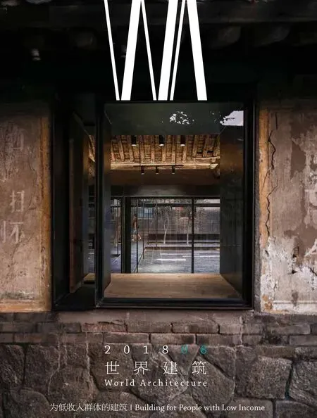
世界建筑 2018年8期
建筑设计:阿尔弗雷多·布利耶博格,休伯特·克隆普纳/城市智库
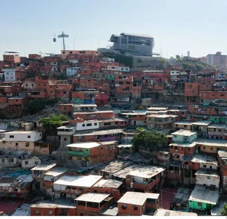
1 远景/Distant view
委内瑞拉的首都加拉加斯位于海拔1000m处一个宽20km的山谷中,城市面积800km2,有近600万人口。就全世界对加拉加斯的通常认知而言,这个城市的形象与委内瑞拉惊人的经济增长、其作为OPEC成员国的角色以及该国领导层面的政治斡旋紧密联系在一起。这是加拉加斯的一个侧面。
实际上,加拉加斯由两个城市构成。一个是正规城市,这里有高楼、安保完善的封闭住宅区、巨大的财富以及私家汽车;另一个则是非正规城市,这里居住着约100万户人家。一直以来,加拉加斯的非正规城市空间持续向东蔓延,相对1950年代的城市面积已经翻了5倍。非正规城市由高密度的破败的建筑构成,大部分依附于加拉加斯外围陡峭的山地上。这些片区基本仅由居民们规划与建造,不具备传统意义上的街道铺地,步行是居民唯一的出行方式,他们依据长期的习惯选择路径沿着陡峭的台阶上上下下。非正规城市的居民没有私家车,如果一定要说这里有交通“系统”,那就是人行道。
在这样的环境下,城市智库(UTT)设计了一种创新的交通方式——公交缆车。2003年7月,UTT在加拉加斯市中心的大学组织了一场非正式但面向公众的演讲与讨论活动,活动主题是反对政府(有关非正规城市空间的)规划并主张开始探索其它的发展可能性。参加活动的有建筑师、规划师、其他领域的专家们、大学的激进主义者以及非正规城市区域的领导。来自圣奥斯汀的演讲者们不仅言辞激烈地表达了他们的反对意见,同时也提出了具有说服力的理由,展现了他们的博学、专业,这使得政府规划师们感到震惊。演讲者们在反对政府规划的同时清楚地表达了他们的诉求,其中包括:保护人行道为主的社区;进行混合功能发展;扩大公园,设计有吸引力的安全的街道空间;增加包括创业机会在内的就业岗位;设立其它各种社区设施。
这是土地用地规划与城市发展中的一个标志性转折点:在此之前,从未有过一个“贫民窟”社区坚持自我塑造未来发展的权利;也从未有过其它社区的利益相关者要求参与到决策阶段。政府终于让步了。
公交缆车与加拉加斯“正规”城市部分的已有公共交通系统相连,线路全长2.1km,单个车厢可容纳8名乘客。此前,哥伦比亚的麦德林市已经试验过采用缆车作为日常交通工具,但是加拉加斯的公交缆车系统的车站将不仅仅承担交通功能,还会是公共服务以及社区活动的中心。
这个缆车系统每小时单向载客量可达1200人。整条线路共有5个站台,其中2个在山谷中,并与城市已有的公共交通系统直接相连,其他3个则沿着山脊分布,保证非正规住宅区的可达性,与该区域已有的人行流线良好连接,并将施工的可持续性纳入考虑以尽量避免拆除已有住宅。□(杨诗雨 译,本文原发表于鲁比出版社2008年出版的 《城市运输》一书,由伊尔卡·鲁比与安德烈亚斯·鲁比编辑)

2 近景/Nearby view
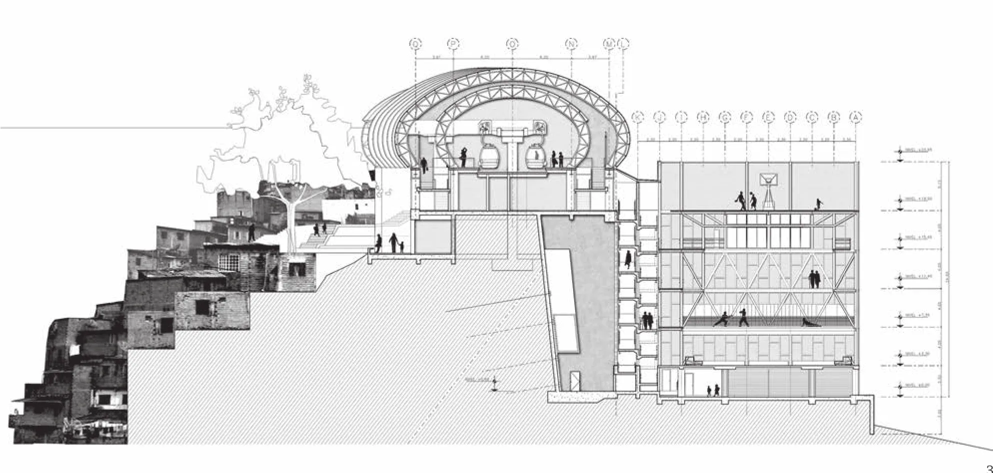
3 剖面/Section

4 鸟瞰/Aerial view
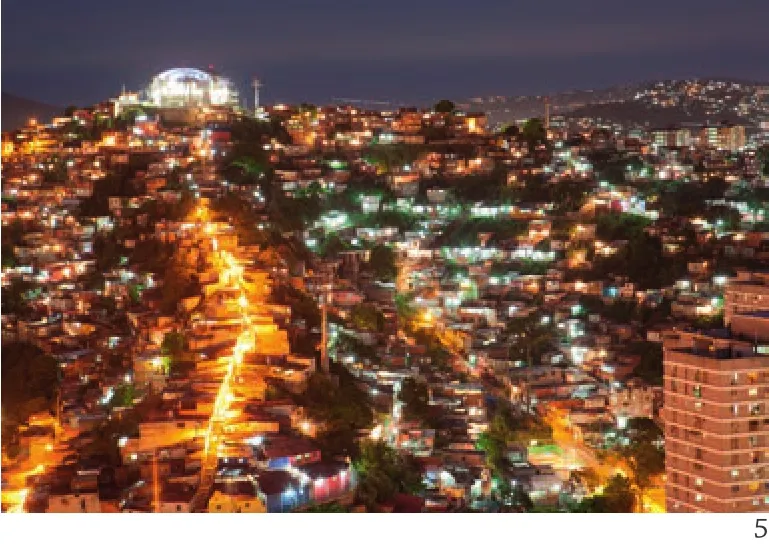
5 夜景/Night views
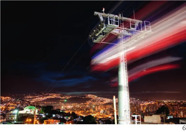
6 夜景/Night views
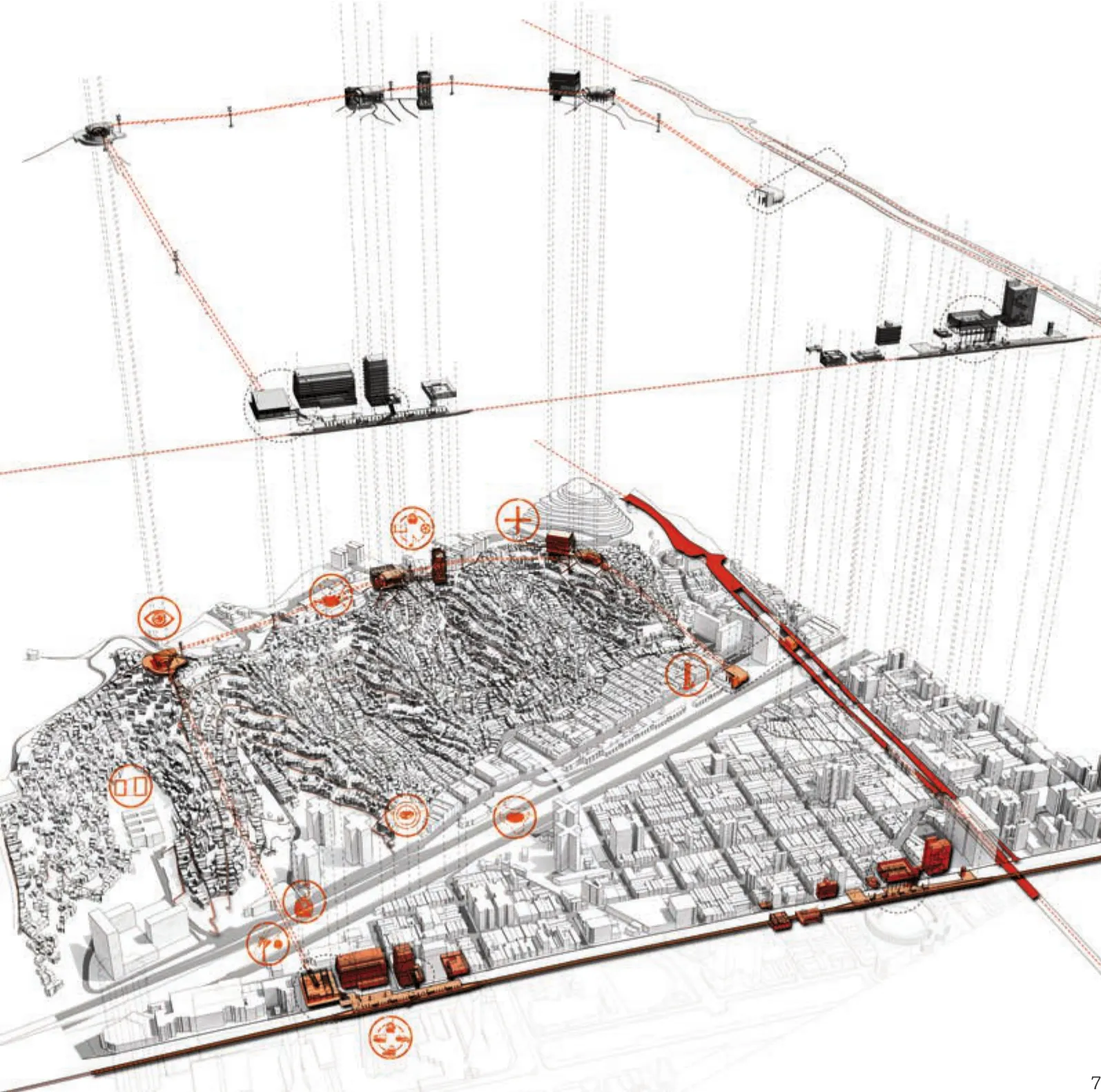
7 整体计划/Overall plan
项目信息/Credits and Data
客户/Client: C.A. Metro Caracas / Oderbrecht
项目主持/Project Leads: Alfredo Brillembourg, Hubert Klumpner
项目团队/Project Team: José Antonio Nunez, Carlos Bastidas, Alfredo Brillembourg, Patrick Edlinger, Elizabeth Florian, Cesar Gavidia, Dora Kelle, Hubert Klumpner, Rafael Machado, Claudia Ochoa, Regina Orvananos, Juan Ponce,Matt Tarczynski
调研、设计、展览/Research, Design, Exhibition: Michael Contento, Lindsey Sherman
景观建筑师/Landscape Architect: Topotek 1 – Martin Rein-Cano, Christian Bohne
平面设计/Graphic Design: Intégral Ruedi Baur & Associés -Ruedi Baur
社区宣传/Community Outreach: Felix Caraballo
竣工时间/Completion: 2010
区域/Area: 2.1 km
预算/Budget: 240,000,000 USD
摄影/Photos: Iwan Baan(fig.1,4), Urban Think Tank(fig.2,5,6)
Caracas, Venezuela, is located some 1,000 metres above sea level, in a 20-kilometre-wide valley – a megalopolis of 800 square kilometres, home to nearly six million people. To the extent that the rest of the world knows Caracas, they associate it with Venezuela's staggering economic growth, its membership in OPEC,the machinations and manipulations of its leadership.That is one Caracas.
But Caracas is dual cities: one is a formal city of tall buildings, homes secured behind guarded gates, enormous wealth, and private transportation and the informal city,and the other an informal city, home to some one million families, sprawling to the east and covering an area four times larger than the city's metropolitan boundaries in the 1950s. Much of this informal city of densely packed, ramshackle structures clings to Caracas' steep mountainsides. Planned and built almost exclusively by the residents themselves, these barrios have no streets in the conventional sense, no paved roadways; people move around on foot, along pathways established by habit, and up and down steep stairs. To the extent that there is a transportation "system": it serves the pedestrians. Barriodwellers do not own cars.
In this climate, the Urban Think Tank (UTT)developed an innovative transport solution known as the Metro Cable. In July of 2003, UTT organised an informal,but very public, presentation and symposium at Caracas'central university to protest the government plan and begin the process of exploring alternatives. Attended by architects, planners, various other experts, university activists, and barrio leaders, the meeting stunned government planners: speakers from San Agustín were not only vehement in their objections, they were eloquent and well-informed. Rejecting the plan, they also articulated very specific demands, among them the preservation of a pedestrian-oriented community; mixed-use development;expanded parks, and attractive, safe streetscapes; sources of employment, including entrepreneurial opportunities;and various other community amenities.
This was a watershed moment in land-use planning and development: never before had a "slum" community asserted the right to shape its own future; never before had stake-holders demanded a role in the decisionmaking. The government backed down.
Integrated with Metro Systems of Caracas, the public transit system provided in the "formal" city,Caracas Metro Cable is 2.1km in length and employs gondolas that hold eight passengers each. The idea of a cable car transportation system has been tested in Barrios in Medellin, Colombia, but the Caracas cable Stations are planned to provide more than just transport but rather conceived as hubs for social services and other community activities.
The total capacity of the system allows 1,200 people to move per hour in each direction. Of its five stations,two are in the valley and connect directly with the existing public transit system; three additional stations are located along the mountain ridge as community accesses,established pedestrian circulation routes, and suitability for construction with minimal demolition of existing housing.□(A version of this text was originally featured in"Urban Transformations", Edited by Ilka & Andreas Ruby, Published by Ruby Press, 2008)
评论
周政旭:基础设施与公共服务向低收入社区/低收入群体延伸是应对贫困问题的惯常选项之一,关键在于以何种方式进入。加拉加斯公共缆车项目显然采取了一种非常直接的方式,在保持异质性并置的基础上,架起了“正规城市”与“非正规城市”之间的沟通之桥,加强两者之间的交通往来与生活文化交流。同时,也创造了鲜明的城市景观,无论是从“看”与“被看”的角度。尤其是从轿厢中俯瞰两种城市形态之时,当更能体会设计师的匠心。
Comments
ZHOU Zhengxu: Extending the infrastructure and public services towards low-income community/lowincome group has been one of the common choices when fighting against poverty, but the key lies in how to extend. The project of Caracas Metrocable apparently adopts a very direct method. On the basis of retaining heterogeneity, it sets up a bridge of communication between a "formal city" and an "informal city", in order to enhance the transportation exchange and life and cultural communication between these two cities. In the meantime,it creates a distinctive urban landscape, no matter from the perspectives of "seeing" or "being seen". The intention of the designer is especially clear when overlooking the two urban forms from the metrocable in air.
鲍威:我们对缆车的认识大都来自于景区或滑雪场,当其作为城市公共交通的策略来为市民提供通勤服务时,似乎显得有些怪诞。但对于加拉加斯这样在地形上展开的既有城市,却显得恰到好处:地形制高点与步行系统对接,在城市边界与公共交通系统对接,成为简单有效的大众运输工具。从建筑上来讲,虽然最初的渲染图似乎更加吸引人,但项目在城市层面上实现的意义已经远超过对建筑本身的讨论。
BAO Wei: Most of our impressions about cable cars come from scenic areas or ski resort, so it looks strange when used as an urban public transport means to provide commuting service for citizens.However, it is in fact perfect for an existing city sprawling on the landform like Caracas: the high points of the land form connect with the pedestrian system, and the system is linked up with the public transport system at the city border, as a simple but efficient people mover. From an architectural perspective, though the initial renderings seem more attractive, the practical significance of the project on municipal level has been far beyond a discussion on the construction itself.
猜你喜欢
环球时报(2019-05-30)2019-05-30
好孩子画报(2019年3期)2019-04-28
小天使·一年级语数英综合(2019年2期)2019-01-10
畅谈(2018年10期)2018-08-27
智能城市(2018年7期)2018-07-10
大科技·百科新说(2018年2期)2018-03-19
自动化学报(2017年1期)2017-03-11
小学阅读指南·高年级版(2016年6期)2016-06-24
中国交通信息化(2016年3期)2016-06-05
中国石油企业(2014年12期)2014-03-01