
Stratigraphy of late Quaternary deposits in the mid-western North Yellow Sea*
2018-12-22 07:00CHENXiaohui陈晓辉LIRihui李日辉LANXianhong蓝先洪WANGYan王燕
关键词:王燕
CHEN Xiaohui (陈晓辉) LI Rihui (李日辉) LAN Xianhong (蓝先洪) WANG Yan (王燕)
1 Key laboratory of Marine Hydrocarbon Resources and Environmental Geology, Ministry of Land and Resources, Qingdao 266071, China
2 Qingdao Institute of Marine Geology, Qingdao 266071, China
Abstract The North Yellow Sea (NYS) is characterized by strong land-sea interaction and paleoenvironmental changes with sea-level fluctuations during the late Quaternary. However, large-time scale depositional stratigraphy in this area and its relationship with sea-level changes remain unresolved. Highresolution seismic profiles from NYS were subdivided into eleven seismic units (U1 to U11 in descending order). A 70.6-m-long borehole (DLC70-2) from localities on seismic profiles, analyzed for lithology,microfossil assemblages and geochronology, comprises eleven sedimentary units (D1 to D11 in descending order), which were clearly correlated with the eleven seismic units. These units constitute four distinctive sequences (SQ1 to SQ4 from top to bottom) bounded by three sequence boundaries (S3, S5 and S10) with obvious depositional hiatus, correlated with sea-level lowstands of MIS2, MIS4 and MIS6, respectively.The lowermost SQ4 below S10, has been identified only upper part of transgressive systems tract (TST)(D11, tidal flat facies in early MIS6). SQ3 overlying S10 consists of a set of lowstand systems tracts (LST)(D10, fluvial to incised-channel filling facies in late MIS6), TST and highstand systems tracts (HST) (D9 to D6, interactive deposits of neritic and littoral facies in MIS5 and early MIS4). SQ2 above S5 is composed of LST (D5, channel-filling facies in late MIS4) and TST (D4, littoral to estuary facies in early-middle MIS3), but lack of HST resulting from subaerial exposure and channel incising during the Last Glacial Maximum (LGM). The uppermost SQ1 overlying S3 comprises LST (D3, channel-filling to flooding plain or marsh facies in MIS2), Holocene TST (D2, littoral and tidal sand ridge facies) and HST (D1, neritic facies). The unusual depositional stratigraphy was largely dominated by sea-level fluctuations and the Bohai Strait topography. This study confirms that TSTs are relative continuous and widely distributed, while LSTs vary considerably in thickness and lateral extent since MIS6 in NYS.
Keyword: late Quaternary; seismic stratigraphy; North Yellow Sea; sea-level fluctuation
1 INTRODUCTION
Sea-level fluctuation is one of the most significant factors affecting the stratigraphic framework and sedimentary evolution on the continental shelf during the late Quaternary. At glacial sea-level lowstand period such as LGM, the shoreline and estuaries retreated seaward, and LST on continental shelf,characterized by depositional hiatuses and incise paleo-rivers, was extensively developed. During deglacial period, sea level began to rise and transgressive deposits overlying LST accumulated on the shelf. Meanwhile, sedimentary environments gradually changed from fluvial-dominated to marinedominated (Saito et al., 1998; Berné et al., 2002; Liu et al., 2007, 2010; Lee et al., 2014; Yoo et al., 2016a).In recent years, based on principles of sequence stratigraphy (e.g. Vail, 1987; Catuneanu, 2006), highresolution seismic profiles combined with sediment data were widely applied to reconstruct stratigraphy and depositional history during the late Quaternary on worldwide continental shelves, e.g. in Bohai Sea (BS)(Marsset et al., 1996; Liu et al., 2009), East China Sea(Saito et al., 1998; Berné et al., 2002; Wang et al.,2014), South Yellow Sea (SYS) (Jin et al., 2002; Liu et al., 2010; Yoo et al., 2016a, b), Otago shelf off New Zealand (Osterberg, 2006) and Aegean Sea (Işler et al., 2008).
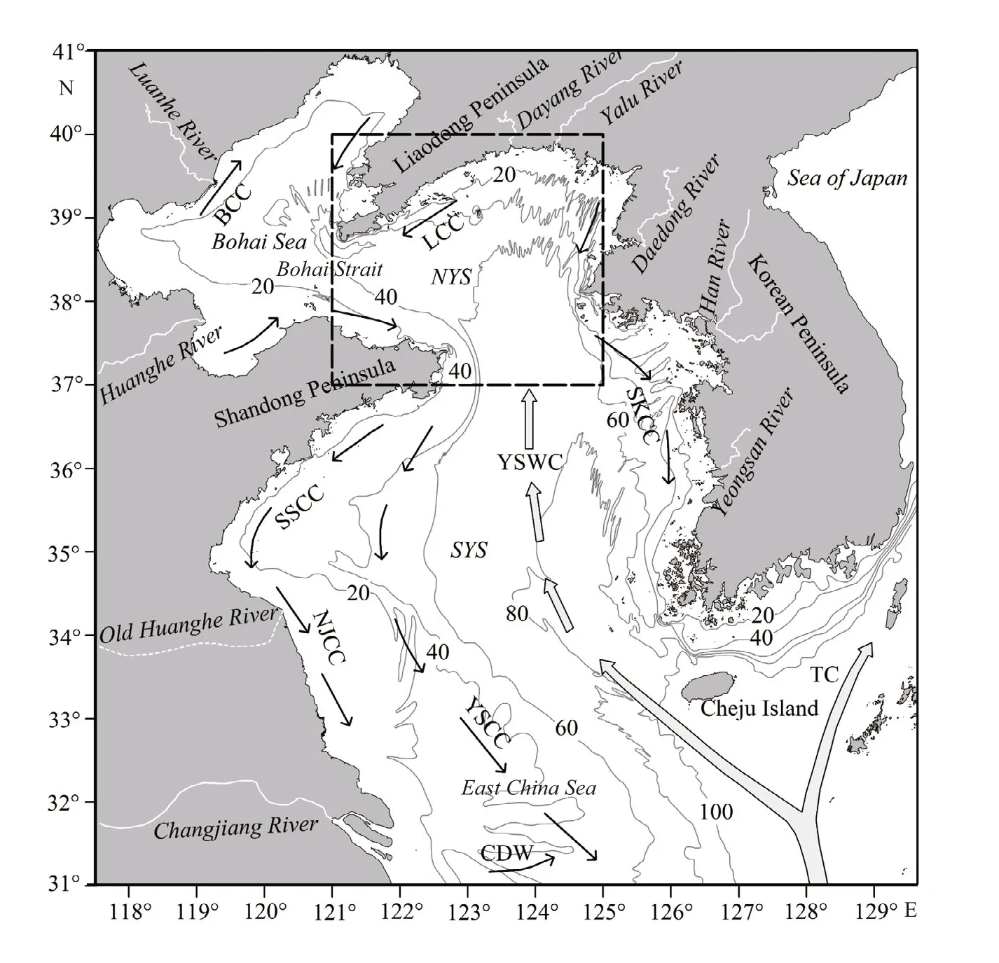
Fig.1 Bathymetry and regional circulation pattern in the Yellow Sea and adjacent areas during wintertime (modified after Su, 1986; Guan, 1983)
The NYS lies on a tectonically stable, shallow and low-gradient shelf surrounded by Liaodong Peninsula,Shandong Peninsula and Korean Peninsula (Fig.1).Sea-level changes, coupled with terrigenous sediment input from large rivers such as the Huanghe (Yellow)River, Yalu River, some rivers in Korean Peninsula,and transported by the Yellow Sea Warm Current(YSWC), played a major role in the depositional evolution of late Quaternary in NYS (Liu et al., 2004,2007; Yang and Liu, 2007; Li et al., 2011, 2014; Chen et al., 2013a). Meanwhile, it is regarded as an important channel for materials and energy exchange between BS and SYS (Liu et al., 1998; Lv et al.,2005). In view of these features, the NYS is a good site for studying late Quaternary stratigraphic sequence and depositional systems.
Early in the 1980s, Milliman et al. (1987) proposed a prominent mud wedge with a maximum thickness of 30 m wrapped around the Shandong Peninsula.Since their pioneering work, a series of studies have been carried out on Holocene stratigraphy and sedimentary evolution in the western NYS, especially alongshore the Shandong Peninsula (Cheng et al.,2001; Liu et al., 2002, 2004, 2007; Yang and Liu,2007). These studies suggested that the Holocene clinoform around Shandong Peninsula can be divided into two distinct stratigraphic units, an underlying TST (ca. 11.6–6.5 cal ka BP) and an overlying HST(after ca. 6.5 cal ka BP), bounded by the maximum flooding surface. A recent work identified seismic stratigraphy in NYS since MIS5 based on the highresolution seismic profiles (Chen et al., 2011).However, the sequence stratigraphy and its relationship with sea-level change during the late Quaternary in NYS have not been clearly illustrated at present because of lack of deep boreholes to construct a precise chronological framework.
In this study, we present and discuss the newly acquired high-resolution seismic profiles, analyze lithological, paleontological and chronological characteristics of a 70.6-m-long core (DLC70-2)obtained from the central NYS, and finally reconstruct the late Quaternary (since MIS6) sequence stratigraphic structure and sedimentary history of NYS.
2 REGIONAL SETTING
The NYS, a typical semi-enclosed epi-continental sea between the Chinese mainland and the Korean Peninsula, is separated from BS to the west by the Bohai Strait and from SYS to the south (Fig.1). The sea floor is relatively flat and shallow in NYS with an average water depth of 38 m (Qin et al., 1989). The seabed deepens gradually southeastward in SYS,where exists a SE-NW-oriented trough (the Yellow Sea Trough) with a maximum water depth of 100 m.There are a group of islands in the western NYS,especially in the Bohai Strait, in which the seabed topography is relatively complex.
The sediment sources in NYS are characterized by diversity, mainly from rivers input and water masses transportation. According to statistics of 30 years at the end of last century, the average sediment discharge from the Liaodong Peninsula to NYS is about 4×10⁶t/a, and the Yalu River and Dayang River account for almost 80% of the sediment discharge(Qin et al., 1989; Fu et al., 1995), while the rivers draining from the Korean Peninsula contribute small amounts of sediments annually (Schubel et al., 1984).Sediments relating to water masses transportation in NYS primarily come from BS and SYS. Huanghe River, as a major sediment source of BS, is well known for its huge sediment discharge, which is about 1.1×10⁹t annually. The amount of sediment contributed to NYS by Huanghe River via the Bohai Strait is 3.3×10⁷t (Liu et al., 2004; Liu and Wang,2014) or even up to 4×10⁷t annually (Bi et al., 2011).The YSWC has a suspended sediment load of 3×10⁶t/a, of which one third is transported from SYS to NYS (Gao et al., 1996).
The NYS is subject to semi-diurnal tides, with the tidal range less than 4 m in the mid-western shelf of NYS and up to 8 m along the western Korean coast(Dong et al., 1989; Chough et al., 2000; Choi et al.,2003). The tidal current velocity vary from lower than 40 cm/s in the central shelf of NYS, to about 40–100 cm/s around the southeast Liaodong Peninsula and larger than 150 cm/s in the northeast NYS (Liu et al., 1984; Dong et al., 1989; Qin et al., 1989).
The ocean circulation of NYS, showing an apparent seasonal variation, mainly consists of two different water masses (Fig.1): the warm and saline YSWC,and the cold and low-salinity coastal currents including the Yellow Sea Coastal Current (YSCC),the Liaonan Coastal Current (LCC) and the South Korean Coastal Current (SKCC). The YSWC flowing northward, can intrude into NYS (Lan et al., 1986)and even into BS during winter (Liu et al., 1998), but is too weak to reach north of 35°N in summer because of the invasion of a cold water mass from the north(Fig.1). The YSCC flows steadily eastward along the northern Shandong Peninsula coast and then turns from Chengshantou to the south at a depth of 40–50 m. The LCC flows constantly southward to the Bohai Strait along the southeast coast of Liaodong Peninsula. While the WKCC flows southward along 40–50-m isobaths of the western Korean coasts(Chough and Kim, 1981; Lee and Chough, 1989; Jin and Chough, 1998; Lee and Chu, 2001). These current systems play a significant role in the transportation,distribution and dispersal of detrital sediments in the NYS (Park and Khim, 1992; Yang and Liu, 2007; Liu et al., 2007; Chen et al., 2013a; Yoo et al., 2016a).
Sediment distribution and geomorphic features in the NYS are controlled by sediment supply and off shore processes such as tides, waves and coastal current (Lee and Chough, 1989; Yang and Liu, 2007)(Fig.2). The eastern NYS is floored by the western Korean Bay tidal sand ridges (WKBTS) formed by strong reciprocating tidal currents (Liu and Xia,2004), and the floor of northeastern Bohai Strait is covered by the southeast Liaodong Peninsula tidal sand ridges (SLPTS) formed by ebb tidal currents(Chen et al., 2013b), while the floor of the midwestern NYS is covered by mud in the relatively low energy environment and comprises two geomorphologic units: 1) Liaodong Peninsula finegrained clinoform (LPFC), a Holocene fine-grained(ST) deposit in the southeast coastal area of the Liaodong Peninsula (Chen et al., 2013a), 2) Shandong Peninsula mud clinoform (SPMC), a Holocene mud(YT or T) deposit around the Shandong Peninsula and in the central NYS (Fig.2) (Milliman et al., 1987; Liu et al., 2004, 2007). Moreover, there exists an erosional area north of the Bohai Strait with a mixture of SG and ST (Liu et al., 1994).
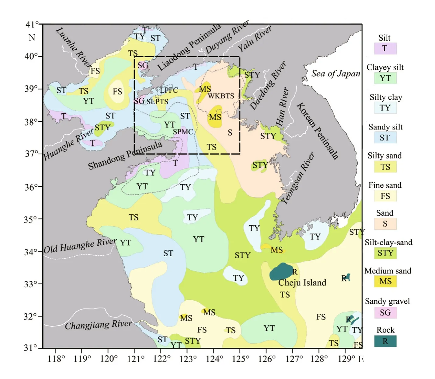
Fig.2 Distribution of surface sediments in the NYS and adjacent seas (modified after Li et al., 2005)
3 MATERIAL AND METHOD
3.1 High-resolution seismic data
During the geophysical survey carried out in December 2008 in NYS by the Qingdao Institute of Marine Geology, Approximately 4 650 km of highresolution seismic profiles were acquired using a 400–500 J SBP/AAE sparker system fired at an interval of 1 000 ms, at a ship speed of less than 5 knots (Fig.3). Seismic records with a vertical penetration of 100 ms two-way travel time were filtered using band pass between 600 HZ and 5 000 HZ. All seismic profiles were interpreted using a constant acoustic velocity of 1 500 m/s to calculate sediment thickness (Saito et al., 1998; Hübscher et al.,2002; Liu et al., 2007).
3.2 Borehole analysis
Borehole DLC70-2 on seismic profiles was obtained from the central NYS (122°24.15′E,38°27.00′N) at 52.8 m water depth in October 2009(Fig.3). The core is 70.60 m long with an average recovery of 89.1%. In the laboratory, the core was split, described, photographed and subsampled. Twoand four-cm-thick subsamples were collected,generally at 20-cm interval for grain-size analysis and microfossil identification, respectively.
A total of 331 grain-size samples were measured with a Malvern Mastersizer 2000 laser particle size analyzer (in range of 0.02–2 000 μm and a relative deviation of reproducibility of about 2%), after pretreating with 10% H2O2and 0.1 N HCl to remove organic matter and biogenic carbonates respectively.Grain-size parameters were calculated using the method by Folk and Ward (1957).
Microfossil analysis of 331 samples was conducted using the standard method (Wang et al., 1985) by examining the >63 μm fraction under a microscope for foraminifera and Ostracoda within each 50 g dry sample. However, the ostracods were almost absent and their abundance was extremely low in core DLC70-2, thus the ostracods data was no statistical significance. The abundances (number of species) and diversities (simple and complex) of the benthic foraminifera were all calculated.
Radiocarbon14C dates of 10 benthonic foraminifera samples in the uppermost 23.00 m were dated by Accelerator Mass Spectrometry (AMS) in Woods Hole Oceanographic Institution. The AMS14C dating results have been reported by Chen et al. (2016).

Fig.3 Geographic map of the study area, showing the survey tracklines of the high-resolution seismic profiles and locations of core DLC70-2 and two previous cores NYS-101 and NYS-102 (Liu et al., 2007)
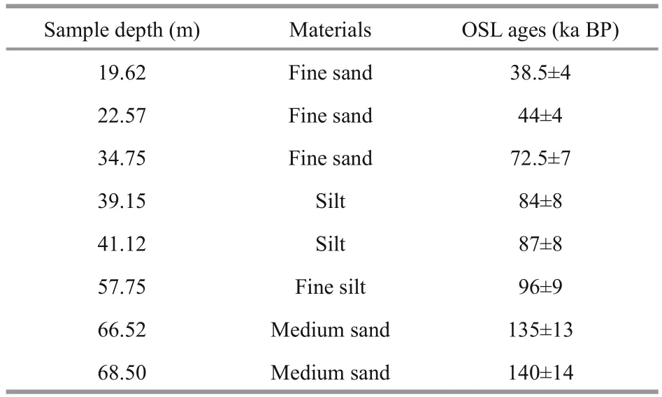
Table 1 List of OSL ages below 22.00 m sediments of borehole DLC70-2
In addition, 8 Optical Stimulation Luminescence(OSL) ages from core DLC70-2 (Table 1) were measured at the center of Testing, Qingdao Institute of Marine Geology using the method reported by Wintle (1997).
4 RESULT
4.1 High-resolution seismic stratigraphy
Eleven distinct seismic units, named U1-U11 from top to bottom, were identified in the study area based on the interpretation of high-resolution shallowseismic profiles. These units show different seismic facies and geometry and are clearly bounded by ten erosional unconformities or distinctive seismic-facies boundaries, designated S1-S10 by descending number(Figs.4–8). In addition, bedrock is identified in the seismic profiles below the erosional surface S2(Fig.8).
4.1.1 Seismic units below S5
The seismic units below S5, including U6, U7, U8,U9, U10 and U11 in descending order, are visible in the central part of NYS but hardly traceable throughout the study area due to multiple reflections from the seabed (Fig.4).
U11, the lowermost traceable unit in this area, is characterized by low-amplitude, relatively continuous and largely subhorizontal internal reflections. The boundary at the top of U11 corresponds to a distinctive sequence boundary (S10), deeply downcutting into the underlying units such as D11. However, the bottom boundary of this unit cannot be traced in most of the study area owing to acoustic interference from multiples (Fig.4).

Fig.4 Part of the east-west seismic profile passing through core DLC70-2
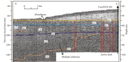
Fig.5 Part of north-south seismic profile passing through previous core NYS-102 (Liu et al., 2007)
U10, directly overlying U11 or older sedimentary strata, is primarily characterized by chaotic, low amplitude and low continuity reflections on the bottom and locally medium-amplitude, continuous internal reflections on the top (Fig.4). The thickness of U10 ranges mostly between 5 and 15 m with a maximum value of ~18 m in the central part of NYS.The top boundary of this unit is a distinct mid-reflector erosional surface S9, which separates U10 from U9 and truncates the underlying U10.
U9 shows low-amplitude, semi-transparent or transparent and continuous reflections. The internal reflectors roughly parallel the underlying top surface of U10 (Fig.4). Furthermore, the overlying boundary of U9, a high-amplitude erosional surface S8, parallels with the internal reflections of U9.
U8 displays medium- to high-amplitude, subhorizontal and relatively parallel internal reflections that onlap to the distinct erosional surface S8. It is overlain by U7 with the erosional surface S7 between these two units (Figs.4, 6 and 8).

Fig.6 Part of north-south seismic profile, with nine seismic units (U1–U9 in descending order) bounded by eight unconformities (S1–S8 in descending order) identified

Fig.7 Part of south-north seismic profile, with seven seismic units (U1–U7 in descending order) bounded by six unconformities(S1–S6 in descending order) identified
In contrast to U8, U7 is characterized by the similar sub-horizontal and continuous internal reflectors but shows relative low amplitude acoustic facies. It is bounded upward by a mostly sub-horizontal but locally undulating (e.g. east of the Bohai Strait)erosional surface (S6). Moreover, this unit is overlain by U6 (Figs.4, 6–8).
The three units, U9, U8 plus U7, have a maximum thickness of 32 m and thin shoreward to less than 5 m in the southeast of Liaodong Peninsula and east of Bohai Strait.
U6, showing high-amplitude, sub-horizontal and relative continuous internal reflection patterns, is bounded on the top mostly by a distinct undulating sequence boundary (S5) marked by V- or U- shaped channels and locally by a erosional surface (S4). This unit is locally irregular in thickness owing to the channel incision from above, and has variable thickness from 0 to 15 m, mostly between 4 and 12 m(Figs.4–8).
4.1.2 Seismic units between S5 and S3
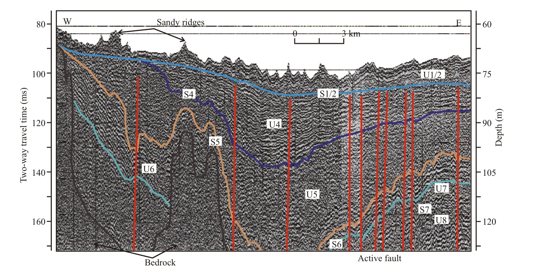
Fig.8 Part of west-east seismic profile, with six seismic units (U1/2 (U1 and U2 merged) and U4–U8 in descending order, U3 was absent) bounded by five unconformities (S1/2 (S1 and S2 merged) and S4–S7 in descending order, S3 was absent)identified
U5 is characterized by faintly stratified and partially chaotic acoustic facies, indicative of channel infill successions (Figs.4–8). It is bounded by a flat-flying erosional surface (S4) on the top and an undulating erosional surface (S5) on the bottom. There are three main trunk channels of this unit roughly oriented NNW-SSE, 3–90 km wide and 0–34 m deep (Fig.9a).
U4 between S3 and S4, or between S2 and S4 where S3 is absent, is composed of two similar subhorizontal and continuous internal reflections subunits showing high to low amplitude from bottom to up. S3 is a distinctive sequence boundary similar to S5,widely downcutting into the underlying strata (U4 or U4 plus U5) (Figs.4–8). Unit U4 is locally reduced to less than 3 m thick or even disappeared at channel incisions. Where erosions are weak or absent, this unit is mostly 10–25 m thick with a maximum value of 33 m and thins shoreward to less than 10 m close to the coastal areas of Shandong Peninsula and Liaodong Peninsula (Fig.9b).
4.1.3 Seismic units above S3
U3 is bounded by the erosional surfaces S3 on the bottom and S2 on the top, and consists of two seismic facies. The lower facies is characterized by lateral alternations of prominent low-amplitude, chaotic reflections with a distinct unconformable basal sequence boundary, which is truncated by the upper facies with high-amplitude and subhorizontal internal reflections when both facies exist together (Figs.4–8).Three main trunk drainage systems of this unit extend across the entire western NYS. These channels are oriented NNE-SSW, 6–117 km wide and mostly 10–20 m deep with a maximum depth of 23 m, and disappear in the northern Bohai Strait and the nearshore area of longitude 38°44′N. The upper facies has a maximum thickness of 6 m in the central of NYS, and is mostly absent in the study area (Fig.9c).
U2, bounded by the erosional surface S2 on the bottom and a maximum flooding surface S1 on the top, is primarily composed of two different seismic facies: mostly the sub-horizontal transgressive clinoform showing high-amplitude, relative continuous reflections, and locally the high-angle transgressive ridge-shaped deposits showing mediumamplitude, discontinuous internal reflections (Figs.4–8). This unit is generally 5–13 m thick along the coastal areas of the Liaodong Peninsula and Shandong Peninsula and thins to less than 2 m in both seaward and shoreward directions. In the nearshore areas of Liaodong Peninsula and Bohai Strait, some sections of unit U2 are directly underlain by bedrock. South of the Liaodong Peninsula, this unit is replaced by four NE-SW individual ridges of 3–17 m thick.
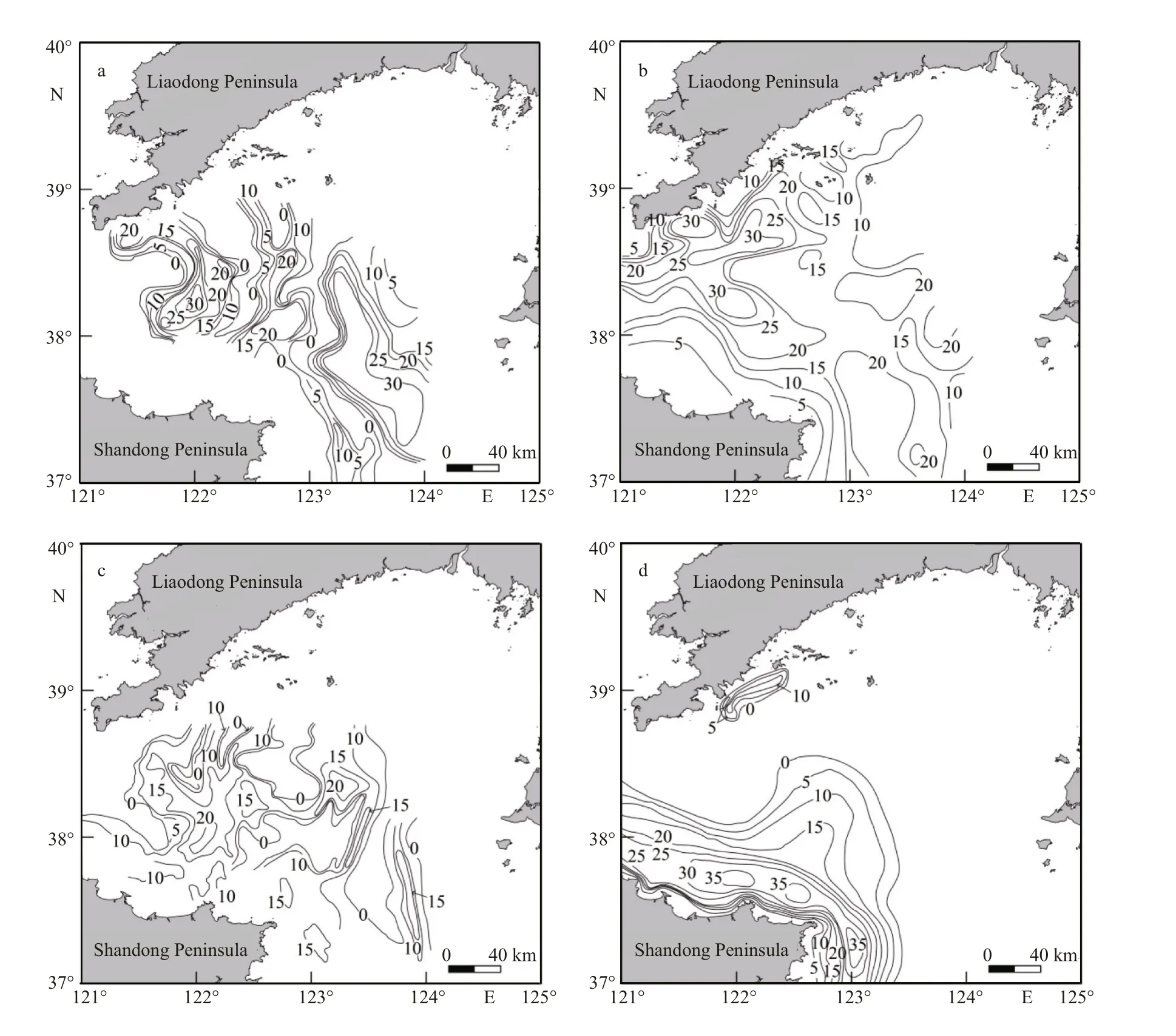
Fig.9 Isopach maps of units U5 (a), U4 (b), U3 (c) and U1 (d)
U1, the uppermost seismic unit, is characterized by bidirectional (seaward and shoreward) low-angle,semi-transparent or transparent, relative continuous internal reflections downlapping onto the maximum flooding surface (S1) beneath. Moreover, the internal reflectors of this unit slope more gently seaward than shoreward (Figs.4–7). In the southeast coastal area of Liaodong Peninsula, U1 is up to 14 m thick and thins seaward or shoreward to less than 0.5 m in water depth of 20–40 m. However, in the nearshore area of Liaodong Peninsula, this unit has a maximum thickness of 40 m and thins shoreward to less than 1 m. Meanwhile, its easternmost and northernmost boundaries can be founded at about longitude 123°26′N and latitude 38°33′E, respectively (Fig.9d).
4.2 Sedimentary stratigraphy
On the basis of lithofacies characteristics, benthic foraminiferal assemblages, AMS14C and OSL dates,eleven sedimentary units of core DLC70-2 since MIS6 were identified, designated D1–D11 in descending order. Moreover, there is a good match between the eleven sedimentary units (D1–D11) and the eleven seismic units (U1–U11, only the upper half of unit U11 was cored) discussed in the above section(Fig.10).
The age model of AMS14C and OSL dates in core DLC70-2 indicates that the core covers a time interval of the late Quaternary, as shown in Fig.11 and Fig.12.The sedimentation rate kept quite unstable, suggesting the variability and complexity of sedimentary environments in NYS during this period. Very low sedimentation rate (6.44 cm/ka) was recorded between MIS3 and MIS2, with a similar rate characteristic during the mid-MIS4, likely suggesting a depositional hiatus. The sedimentation rate reached the maximum value of 952.38 cm/ka (averaging 471.69 cm/ka)during the early Holocene, and then decreased to a low value of 29.33 cm/ka during the mid-late Holocene. The results are consistent with that of Liu et al. (2007) with an average rate 521 cm/ka during the early Holocene and Nan et al. (2017) with the sedimentation rate ranging from 18 to 161 cm/ka during the mid-late Holocene in NYS, respectively.
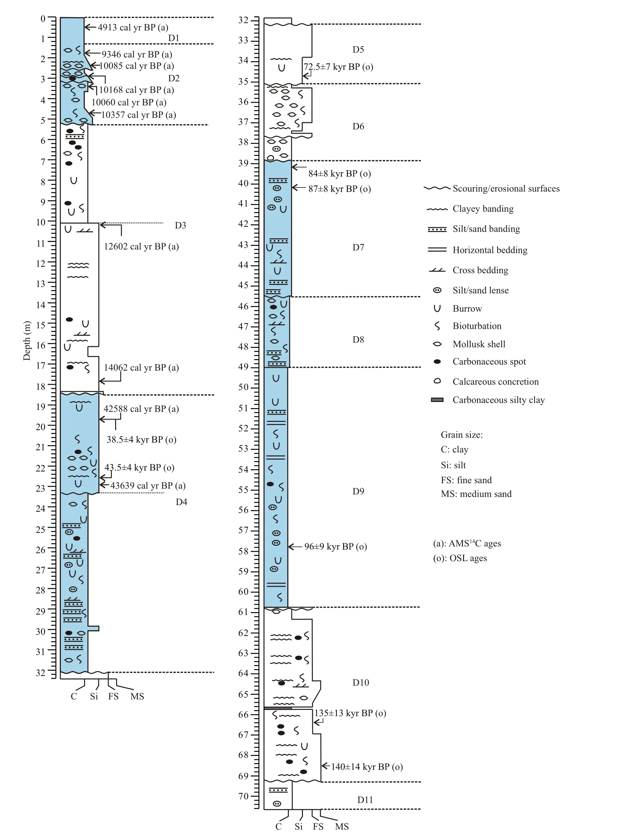
Fig.10 Geologic column of core DLC70-2

Fig.11 Downcore variations of grain size compositions and age-depth model of core DLC70-2
D11 (70.60–69.23 m).
This unit is mostly composed of dark gray silty clay with relative moderate sorting, locally intercalated with fine-grained sand layers or lenticular beds (Figs.10, 11), and exhibits characteristics of tidal bedding (i.e., parallel lamination, lenticular bedding).It is sharply bounded at its top by the overlying unit D10, indicative of the sedimentary environment mutation. The benthic foraminiferal assemblages in this unit are dominated byProtelphidiumtuberculatumandBuccellafrigida(Fig.12), the typical cool-water species (Wang et al., 1985; Yang et al., 1998), common on other shelves deposits during the late Quaternary(e.g. Liu et al., 2010; Wang et al., 2014), and secondarily byAmmoniabeccariivars., the typical euryhaline brackish species (Wang et al., 1985; Yang et al., 1998). All these species show a remarkable decrease upward in abundance. Two OSL dates in the overlying unit D10 are 140±14 and 135±13 ka BP,respectively. On the basis of the lithofacies and assemblages of benthic foraminifera, Unit D11 is interpreted to have been deposited in a gradually shallowing tidal-influenced coastal environment and as a tidal-flat facies, which is formed before the sealevel lowstand of MIS6.
D10 (69.23–60.72 m).
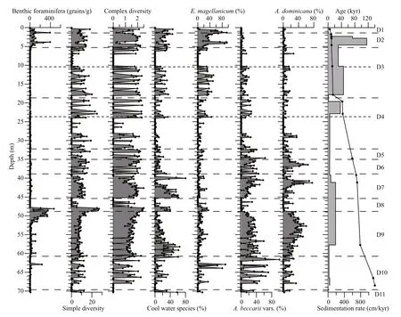
Fig.12 Downcore changes of foraminifera assemblages and age-depth model in core DLC70-2
This unit corresponds to the seismic facies U10 below the ravinement surface S9. It is primarily characterized by gray-brown fine-grained sand,intercalated with thin layers of gray silty clay (Fig.10).Bioturbation, carbonaceous mottles are common, and shell fragments and biologic burrows are sporadic.Reddish mottles and brown rusty stains scatter in the lower part of this unit, and a 3-cm-thick yellowish brown clay layer develops between 67.92 and 67.95 m(Fig.10), suggesting subaerial exposure during the early depositional stage of this unit. A 5-cm-thick dark gray carbonaceous silty clay layer occurs between 65.65 and 65.60 m. Parallel bedding and lenticular bedding were observed in the upper part,indicating distinctive tidal influence during the late stage of this unit. This unit displays large fluctuations in sediment grain size, with average grain sizes ranging between 2.0 and 6.5 Φ (Fig.11). On the basis of the downcore distribution of the benthic foraminifera, unit D10 can be subdivided into two sections. In the lower section (69.23–67.90 m), the benthic foraminiferal assemblages are almost absent(Fig.12), which, together with the lithological change,suggest that there is a distinctive sedimentary hiatus between units D10 and the underlying D11. In the upper section (67.90–60.72 m), the abundance of benthic foraminifera is relative low, averaging 10.5,and the simple diversity and complex diversity of foraminifera vary considerably. The assemblages are dominated by the euryhaline brackish species ofAmmoniabeccariivars. and the coastal to shelf species ofElphidiummagellanicum(Fig.12) (Wang et al., 1985; Yang et al., 1998; Liu et al., 2007, 2009,2010), which overall increase upward. In addition, the cool-water species includingProtelphidium tuberculatumandBuccellafrigidaare relatively abundant in the uppermost part of this section.
Based on the lithofacies and downcore distributions of benthic foraminiferal assemblages, in conjunction with the two OSL ages mentioned above, unit D10 is interpreted as the record to reflect an overall upwardrising trend of sea level. It started as a fluvial facies during the sea-level lowstand of MIS6, followed by channel filling facies under tidal influence in a gradually deepening environment during the late MIS6.
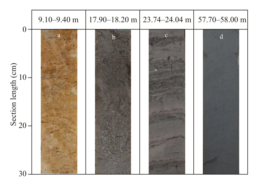
Fig.13 Photos of representative sedimentary facies of core DLC70-2
D9 (60.72–48.90 m).
Corresponding to the seismic unit U9 between S9 and S8, This unit is mainly composed of dark gray clay with good sorting (Fig.13d), locally interlaminated with gray-brown clayey silt layers or lenses.Horizontal bedding is common, carbonaceous spots are sporadic, and weak bioturbation and occasional burrow are scattered throughout this unit (Fig.9). This unit displays a basal erosional boundary and weak coarsening-upward succession. The grain sizes of unit D9 are relatively invariable, with the average grain sizes ranging between 7.1 and 5.5 Φ (averaging 6.7 Φ) (Fig.11). The abundance of benthic foraminiferal assemblages in D9 is much higher than in underlying unit D10, averaging 62.0, and shows an overall upward-increasing trend. However, the assemblages are dominated in the lower section (60.72–56.00 m)by the cool-water species includingProtelphidium tuberculatumandBuccellafrigidawith an average content of 31.1%, and in the upper section (56.00–48.90 m) by littoral species includingAmmonia beccariivars. andAmmoniadominicanawith an average content of 59.7% (Fig.12). Such cool-water species assemblages have been reported in SYS (Ye et al., 1996; Yang et al., 1998; Liu et al., 2010) and in BS(IOCAS, 1985) during the early MIS5, which agree well with the OSL date in D9 in the study area. We thus infer that this core section was formed during the early stage of MIS5.
On the basis of its lithofacies and foraminiferal assemblages, unit D9 is interpreted as a neritic facies on the bottom and a littoral facies on the top,demonstrating a shallowing-upward environmental transition from shelf to littoral zone during the early MIS5.
D8 (48.90–45.42 m).
This unit corresponds to the seismic facies U8 between S8 and S7, and is primarily characterized by dark gray silty clay, interbedded with gray-brown fine-grained sand in the lowermost 1 m. Shell fragments and bioturbation are common, and carbonaceous mottles are sporadic in the uppermost 1.2 m (Fig.10). An erosional contact with its overlying unit D7 occurs at the top. It roughly exhibits a finingupward trend with larger grain sizes (averaging 6.0 Φ) (Fig.11) than that in the underlying unit D9. The benthic foraminiferal assemblages in D8 show a remarkable decrease upward in both abundance and diversities, and even can be absent in the uppermost 1.2 m, where the content of organic matter can reach the highest of core DLC70-2. The assemblages are dominated except the uppermost 1.2 m by the coolwater species includingProtelphidiumtuberculatumandBuccellafrigida, with secondary coastal to shelf speciesElphidiummagellanicum(Fig.12). Two OSL dates in the silty section at 41.12 m and 39.15 m depth in the overlying unit D7 are 87±8 and 84±8 ka BP,respectively. This unit is interpreted as a neritic facies and a lake facies from the bottom up, suggesting a shallowing-upward environmental transition from open shelf to restricted lagoon during the middle MIS5, which is supported by the lithofacies, downcore distributions of organic matter and foraminiferal assemblages.
D7 (45.42–38.90 m).
This unit corresponds to the seismic facies U7 between S7 and S6. It is characterized by dark gray clayey silt with moderate to poorly sorted, intercalated with gray-brown sandy layers and lenses. Lenticular bedding is common with scattered borrows and occasional bioturbation, cross bedding is sporadic(Fig.10). This unit shows a roughly fining-upward succession with an erosional surface at the bottom.The average grain sizes range between 4.4 and 7.2 Φ(Fig.11). The abundance of benthic foraminiferal assemblages in D7 is relative low, averaging 6.2. The assemblages are dominated in the lower part by the cool-water species ofProtelphidiumtuberculatumandBuccellafrigidashowing an overall decrease upward in abundance, and in the upper part by littoral species ofAmmoniabeccariivars. andAmmoniadominicanawith a roughly upward-increasing trend(Fig.12). The down-core distribution of the assemblages suggests that this unit was deposited in a generally shallowing-upward environment. Two OSL dates mentioned above indicate that unit D7 was deposited during the late MIS5. The lithofacies and distributions of foraminiferal assemblages suggest that this unit is interpreted as a neritic facies followed by a littoral facies.
D6 (38.90–35.00 m).
Corresponding to the seismic facies U6 between S6 and S5 (or S4 where S5 and S4 merged). This unit is mainly composed of gray to dark gray clayey silt in the lower part, interlaminated with millimeter-scale lenses of fine sand and shell fragments. Sporadic calcareous concretions are observed at the bottom. It changes upward into dark gray fine-grained sand intercalated with clayey silt layers, and shell fragments and bioturbation are common (Fig.10). This unit is characterized by overall coarsening-upward sequence with an obvious erosional surface at the top. The average grain sizes mainly range between 2.6 and 6.4 Φ (Fig.11). The abundance of benthic foraminiferal assemblages is far less than in the underlying unit D7,averaging 4.5. The dominant species are littoral species ofAmmoniadominicanaandAmmonia beccariivars., which show an upward-increasing trend. The cool-water species ofProtelphidium tuberculatumandBuccellafrigidaare relative abundant in the lowermost part of this section and display an upward-decreasing trend (Fig.12). One OSL date in the fine-sand section at 34.75 m depth in the overlying unit D5 is 72.5±7 ka BP, which together with the two OSL dates in the underlying unit D7 suggest that unit D6 was deposited during the early MIS4. Based on the lithofacies and foraminiferal assemblages, unit D6 is interpreted as a littoral facies in a shallowing-upward environment.
D5 (35.00–32.10 m).
This unit corresponds to the seismic facies U5 between S5 and S4. It is roughly characterized by gray to gray brown silt interlaminated with millimeterscale layers of dark gray clay and weak bioturbation in the middle and lower parts with moderate to good sorting, but grades upward into gray-brown finegrained sand in the uppermost 2 m with bad sorting(Figs.10, 11). This unit generally displays a coarsening-upward succession as in the underlying unit D6 but with a smaller average grain-size ranging between 3.6 and 5.4 Φ (Fig.11). The benthic foraminiferal assemblages are relative low in abundance, averaging 2.2, and even almost absent in the middle part. The assemblages are mainly dominated by littoral species includingAmmonia dominicanaandAmmoniabeccariivars., with secondary coastal to shelf speciesElphidium magellanicum(Fig.12). On the basis of its lithofacies and foraminiferal assemblages, together with the OSL date mentioned above in this unit, unit D5 is interpreted as a channel-filling facies in estuary during the late MIS4.
D4 (32.10–18.50 m).
Corresponding to the seismic facies between S4 and S3 (or S2 where S3 and S2 merged), unit D4 has a lower muddy section (32.10–23.30 m) and an upper sandy section (23.30–18.50 m), with a 20 cm-thick erosional sandy bed separating it from the overlying unit D3 (Figs.10–12).
The muddy section is mainly composed of gray to gray-brown clayey silt, interbedded with thin (<5 cm thick) fine-grained sand layers and lenses that exhibit wavy, lenticular and cross bedding (Fig.13c), with moderate to good sorting. Moderate and locally strong bioturbation and burrows are common, and shell fragments and carbonaceous spots are scattered(Fig.10). The abundance of benthic foraminiferal assemblages is more higher than that in the underlying unit, averaging 3.6 but declining to less than 0.5 in the uppermost 4 m. The dominant species are littoral species includingAmmoniadominicanaandAmmonia beccariivars. (Fig.12). Two OSL dates in the sandy section at 22.57 m and 19.62 m depth are 43.5±4 and 38.5±4 ka BP, respectively, and two AMS14C dates of benthic foraminifera at 22.87 m and 19.62 m are 43 639 and 42 588 cal a BP, respectively. On the basis of its lithofacies and fossil assemblages, the muddy section is interpreted as a littoral facies evidently tideinfluenced during the early MIS3.
The sandy section is characterized by gray-brown silt, interbedded with gray to dark gray silty clay layers with bad sorting, showing an upward-increasing trend of grain-size range. A bed 50-cm thick consisting of shell fragments is at the basal part. Moderate Bioturbation and burrows occur, and carbonaceous spots are sporadic. This section is sharply bounded at its bottom by the underlying muddy section (Fig.10).The abundance of benthic foraminiferal assemblages is much higher than in the underlying muddy section,averaging 4.1. The assemblages are mainly dominated by coastal to shelf speciesElphidiummagellanicumand secondarily by cool-water species includingProtelphidiumtuberculatumandBuccellafrigida,which exhibit an upward-decreasing trend indicating a shallowing-upward environment (Fig.12). Two OSL dates and two AMS14C dates mentioned above suggest that this section was deposited during the middle MIS3. The lithofacies and distributions of foraminiferal assemblages suggest that the sandy section is interpreted as an estuary facies in a shallowing-upward environment.
D3 (18.50–5.10 m).
Corresponding to the seismic facies U3 between S3 and S2, this unit can be subdivided on the basis of its lithofacies and fossil assemblages into two sections, the lower section (18.50–10.02 m) and the upper section (10.02–5.10 m) (Figs.10–12).
The lower section is mainly consists of gray-brown to yellowish brown silt (Fig.13b), locally intercalated with gray to dark gray silty clay layers that exhibit wavy and cross bedding. Bioturbation and burrows occur occasionally, and carbonaceous spots are scattered in the lower part (Fig.10). It shows roughly a fining-upward sequence with average grain sizes ranging between 3.2 and 7.2 Φ (Fig.11). The abundance of benthic foraminiferal assemblages is relative low, averaging 4.4, and the simple diversity and complex diversity of foraminifera fluctuate greatly. The dominant facies are coastal to shelf speciesElphidiummagellanicumwith roughly upward-increasing percentage, and cool-water species includingProtelphidiumtuberculatumandBuccella frigidaare also relatively abundant in this unit(Fig.12). Two AMS14C dates of benthic foraminifera at 17.82 m and 10.25 m depth are 14 602 and 12 602 cal a BP, respectively. It is interpreted as a channel-filling facies in estuary deposited in a gradually deepening shelf environment since the LGM, which is consistent with the lithofacies and downcore distribution of benthic foraminiferal assemblages. The age/sedimentation rate-depth models reflect a distinctive depositional hiatus with its underlying unit D4.
The upper section is characterized by yellowish brown to gray-brown clay with clear massive structure, that is a hard clay (Fig.13a). Bioturbation,burrows and carbonaceous spots are common both in its lower and upper parts, and shell fragments are scattered at the top. It is gradually bounded at its bottom by the underlying channel-filling deposits with a disconformity between them, and sharply bounded at its top by the overlying unit D2 (Fig.10).This section shows an overall coarsening-upward sequence with average grain sizes mainly varying between 5.5 and 7.8 Φ (Fig.11). It displays the lowest abundance and diversities of benthic foraminiferal assemblages among all the eleven depositional units of core DLC70-2. The assemblages are almost absent in the middle to lower parts of this section, and shows low abundance in the upper part, where the dominant facies are coastal to shelf speciesElphidium magellanicumand cool-water species ofProtelphidiumtuberculatumandBuccellafrigida,suggesting that the study area was evidently affected by seawater during the late stage of the formation of the hard clay (Fig.12). Five AMS14C dates in the overlying section indicate that the lower section was deposited before 10 357 cal a BP, which, in conjunction with the AMS14C dates mentioned above in the lower section, suggests that this section was formed from about 12 602 to 10 357 cal a BP, which is highly coincident with the age of the Younger Dryas event,the most significant cold climatic event during the last deglacial warming and occurred between 12.9–11.6 ka (Broecker and Denton, 1989). The correlative peat layers in NYS, formed in different sedimentary environments during the Younger Dryas cooling period (Chen et al., 2014), have been reported to have similar assemblages (Liu et al., 2007; Li et al., 2010),which matches very well with the hard clay in this study (Fig.12). The lower section of D3 is interpreted as the flooding plain facies during the middle to late stages of the Younger Dryas event (Chen et al., 2014).
D2 (5.10–1.32 m).
Corresponding to the seismic facies U2 between S2 and S1, unit D2 is mainly characterized by yellowish brown to gray-brown, bad-sorted, clayey silt, with occasional bioturbation and abundant shell fragments. Two beds of silt 15 cm and 95 cm thick consisting of shell fragments are observed in the lower and middle parts, respectively (Fig.10). The abundance of benthic foraminiferal assemblages is far higher than in the underlying unit D3, averaging 94.8.The assemblages are mainly dominated by coastal to shelf speciesElphidiummagellanicumand secondarily by cool-water species ofProtelphidium tuberculatumandBuccellafrigida, between which there is a reciprocal relationship (Fig.12). Six AMS14C dates in D2 and its overlying unit indicate that this unit was deposited during the early-middle stage of Holocene. Together with the lithofacies and characteristic distributions of foraminiferal assemblages, this unit is interpreted as a littoral facies,demonstrating an environmental transition between nearshore and shallow sea under sea-level oscillations during the early-middle Holocene. The poor sorting,slight bioturbation and abundant shell fragments reflect rapid sedimentation of coastal area. The result is consistent with the sedimentation rate-depth model in Fig.11 and Fig.12.
D1 (1.32–0 m).
Corresponding to the seismic facies U1 between S1 and the sea bottom, this unit is composed of dark gray moderate-sorted clay, with average grain sizes ranging between 6.3 and 7.0 Φ (Figs.10 and 11). The benthic foraminiferal assemblages are much higher in abundance than that in all of the underlying units. The assemblages average 115.6 in abundance and are mainly dominated by coastal to shelf speciesElphidiummagellanicumwith obvious upwarddecreasing percentage and cool-water species includingProtelphidiumtuberculatumandBuccella frigidawith an overall upward-increasing trend(Fig.12). Based on the lithofacies and foraminiferal assemblages, together with the AMS14C dates mentioned above, unit D1 is interpreted as a neritic facies in a shallow-sea environment since sea-level highstand of Holocene.
5 DISCUSSION
5.1 Sequence stratigraphy
The stratigraphic successions since MIS6 in NYS are composed of four depositional sequences (SQ1,SQ2, SQ3, SQ4 in descending order). These sequences are bounded by the sequence boundaries (S3, S5, S10 in descending order) and subdivided into different systems tracts by unconformable surfaces (Fig.14).
Multi-proxy analyses of core DLC70-2 in this study and two existing cores NYS101 and NYS102 in the northern Shandong Peninsula (Liu et al., 2007)(Fig.15), indicate that the youngest sequence boundary S3 was focused on the period of LGM,presumably attributed to subaerial exposure and erosion associated with fluvial incision during multiple phases of sea-level fall and lowstand and ensuring rise of MIS2 before 14 062 cal a BP. The exact age represented by S3 is very difficult to identify,largely due to lacking direct evidence. The bottom boundary of SQ1 truncates its underlying deposits of SQ2 or even SQ3, developing during the late MIS4 to the early-middle MIS3 and the late MIS6 to the early MIS4, respectively. There exists a notable hiatus between SQ1 and SQ2 (Fig.14). Previous shelf-wide unconformities S5 and S10, very similar in characteristics to S3, resulted from the equivalent phases of subaerial erosion during the lowstand of the middle MIS4 and middle MIS6, and downcut into the underlying strata formed before the middle MIS4 and middle MIS6, respectively. This pattern has been recognized on worldwide continental shelves, for instance, in East China Sea (Berné et al., 2002), SYS(Jin et al., 2002; Liu et al.,2010; Yoo et al., 2016a, b),Otago shelf off New Zealand (Osterberg, 2006) and Mediterranean shelf (Çağatay et al., 2009; Gámez et al., 2009).
Forced regressive systems tract (FRST) is generally characterized by sandy prograded sedimentation during the period of sea-level fall by seismic reflections (Hunt and Tucker, 1992). However, the former FRST or even more deeper deposition in NYS were mostly eroded and removed by the paleo-rivers developed during the sea-level lowstand of MIS6, the late MIS4 and LGM. Consequently, the FRSTs are difficult to be identified and distinguished from the overlying and underlying strata in the study area. In this study, the depositional sequences of the NYS during the late Quaternary closely follow the partition pattern of LST, TST and HST.
The lowermost SQ4 below the sequence boundary S10 has been identified only one sedimentary unit D11 (Fig.14). Moreover, only the upper half of seismic unit U11 with an unrecognized bottom boundary was cored as D11. This unit is regarded as the tidal flat facies deposited during the period of sealevel fall of the early MIS6 and represents TST.
SQ3 comprises five sedimentary units (D6 to D10 in descending order) (Fig.14). The lowermost unit D10, overlying the sequence boundary S10,corresponds to a fluvial facies and the ensuing channel filling facies during the period from sea-level lowstand to rising of the middle-late MIS6 and thus represents LST. The upper four units (D9 to D6), with a trangressive erosional surface S9 formed by sea-level rise following MIS6 on the bottom and three erosional surfaces created by sea-level fluctuations during the period from MIS5 to early MIS4 among them, are regarded as alternate deposits between neritic and littoral facies and belong to TST and HST with sealevel fluctuations related to three sea-level maxima corresponding to MIS5e, 5c, 5a, respectively(Williams et al., 1981). However, the maximum flooding surfaces that separates TST and HST units were not clearly documented neither in the seismic profiles nor in the borehole in NYS, possibly because they are frequently reworked and amalgamated with the transgressive erosional surface with sea-level fluctuations during MIS5. Meanwhile, the uncertainty largely results from the resolution limitation of seismic data and lack of precise age dating.
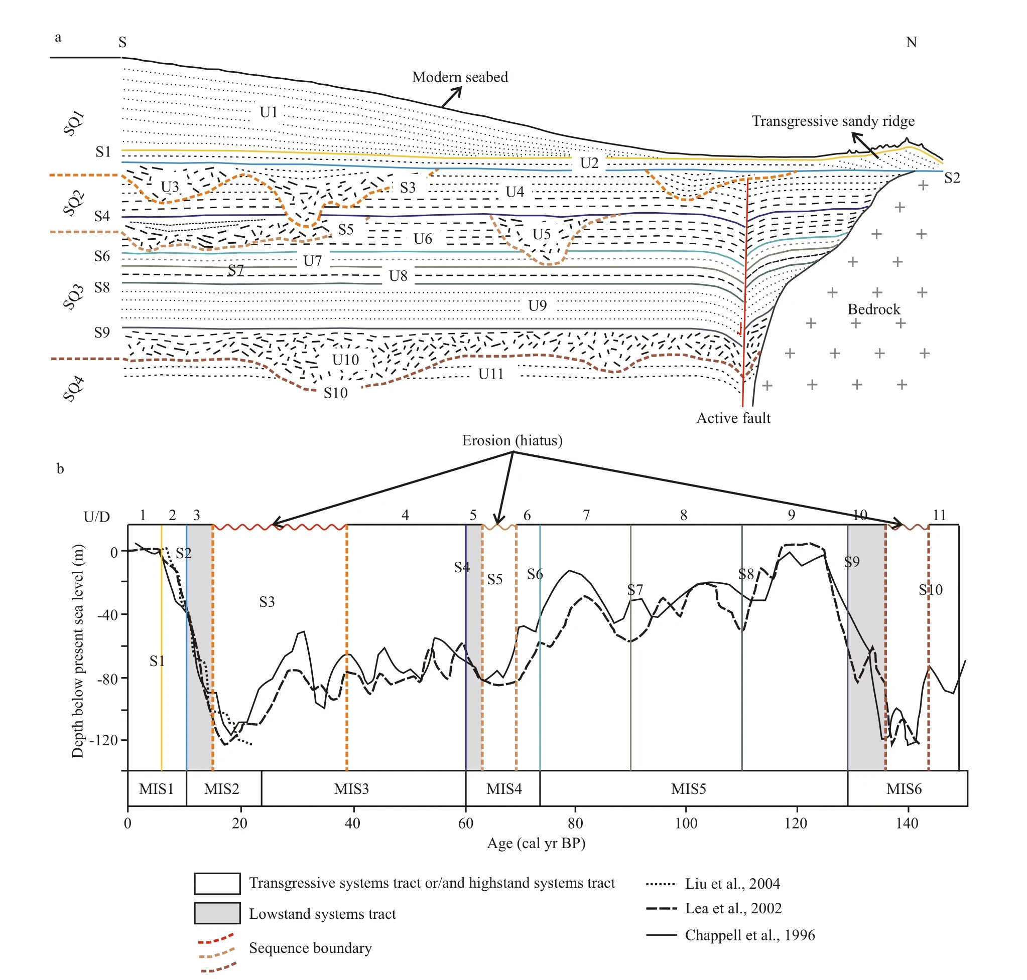
Fig.14 Late Quaternary sequence stratigraphy in the study area
SQ2 is composed of two depositional units (D4 on the top and D5 on the bottom) (Fig.14). The lower unit D5, above the sequence boundary S5, corresponds to the channel-filling facies in estuary during the late MIS4 and represents LST. The upper unit D4,overlying the ravinement surface S4, started as a littoral facies evidently tide-influenced and followed by an estuary facies with sea-level fluctuations during the early-middle MIS3. Unlike Sequence I, Sequence II consists only of LST and TST, but lack of HST resulting from subaerial exposure and channel incising of sequence boundary S3 during LGM.
The uppermost SQ1 consists of three sedimentary units (D1 to D3 in descending order) (Fig.14). The lowermost unit D3, overlying the sequence boundary S3, is regarded as a channel-filling facies in estuary followed a flooding plain facies during the period from ~14 062 cal a BP to ~10 357 cal a BP and thus belongs to the LST. The middle unit D2, above the trangressive erosional surface S2, is interpreted as the littoral facies locally tidal sand ridge facies during the Holocene transgression and represents the TST. The uppermost unit D1, downlapping onto the maximum flooding surface S1, is interpreted as the neritic facies majorly river-derived fine-grained deposits correlated with the modern circulation since sea-level highstand of Holocene and represents the HST. Such depositional sequence has been reported off the Shandong Peninsula in NYS (Liu et al., 2007) (Fig.15).
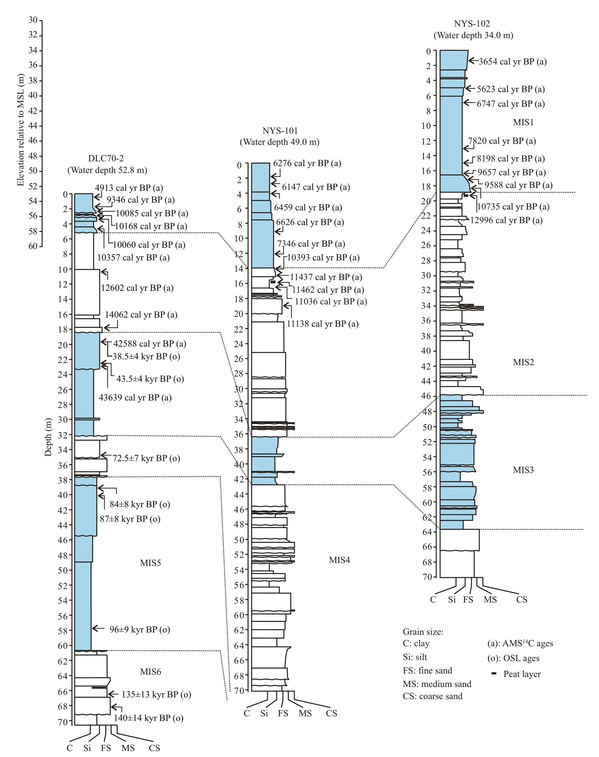
Fig.15 Stratigraphic comparison and correlation of core DLC70-2 (this study) with cores NYS-101 and NYS-102 (Liu et al.,2007) (see Fig.3 for the locations)
The TSTs deposits are overall thin layers and widely distributed in NYS, which resulted from rapid transgression with sea-level rise over the wide and low-gradient continental shelf. In such cases, the transgressive units (TSTs) tend to be dispersed widely over the shelf instead of developing thick backstepping deposits (Yoo and Park, 2000; Cattaneo and Steel,2003; Liu et al., 2004; Dung et al., 2013). The LSTs deposits show appreciable variability in thickness and lateral extent compared with other deposits in NYS,which is possibly due to that high energy paleo-rivers were discontinuous and laterally limited and tended to incise the exposed shelf during sea-level lowstand period. Moreover, the absence of incised channel fills reflectors in the seismic profiles was presumably due to the lack of paleo-rivers progradation and ensuing transgressive filling processes in the study area, as reported on other shelves in previous studies (Liu et al., 2009, 2010; Wang et al., 2014; Lee et al., 2014;Yoo et al., 2016a, b).
5.2 Stratigraphic development since MIS6
Sea-level fluctuation and sediment supply are the major factors controlling coastal and shelf stratigraphic framework and depositional environments during the late Quaternary (e.g., Liu et al., 2007; Wang et al.,2014). Evidence from high-resolution seismic signatures, ages and sedimentary characteristics of core DLC70-2 in this study and two existing cores NYS101 and NYS102 in northern Shandong Peninsula (Liu et al., 2007) (Fig.15), distinctly suggest that sea-level changes since MIS6 predominantly determined the stratigraphic framework and sedimentary environments in NYS. Some active faults, observed in the strata of NYS during the late Quaternary, particularly in western NYS, have an influence on strata thickness but less on stratigraphic structure compared with sea-level changes. In addition, another determinant of sedimentary environments in response to sea-level fluctuations in NYS is basin morphology, especially that of eastern Bohai Strait. The strait was distinctly shallower in late Pleistocene than today and has been eroded by strong tidal currents since early Holocene (Liu et al.,2007, 2009; Chen et al., 2013b). The change largely accounts for diversity of sedimentary environments in response to different sea-level regimes since MIS6 in NYS. Thus, in the following discussions, the sedimentary evolution in NYS in response to global sea-level fluctuations (Chappell et al., 1996; Liu et al.,2004) together with topography since MIS6 will be detailed.
During early MIS6, when global sea-level was not up to its minima, tidal currents played a dominant role in transportation and deposition of sediments on the continental shelf, and a tidal-flat facies D11 was deposited in NYS. Such tidal-influenced depositional system was also developed in SYS (Yang, 1994; Liu et al., 2010) and East China Sea (Berné et al., 2002)during this period. Sea level fell gradually until the middle MIS6, when sea level lowstand was comparable to LGM (~120 m below the present sea level) (Chappell et al., 1996; Lea et al., 2002),resulting in the subaerial exposure of the preceding marine strata D11 in NYS. The high sill of the Bohai Starit obstructed sediment transportation of the BS from entering the study area. The paleo-rivers draining around the NYS developed and incised the underlying strata in the study area (Liu et al., 2009; Lan et al.,2015). Following the ensuing sea-level rise of late MIS6, the coastal line retreated landward, and the incised channels were filled (Yang, 1993; Berné et al.,2002; Liu et al., 2010), such as D10 in the study area.
During MIS5, sea level was up to its modern position (or even higher during MIS5e) (Chappell et al., 1996; Lea et al., 2002), when marine conditions featuring shallow-sea cool-water environment persisted in the shelf area, which leaded to formation of extensive marine deposits or interactive deposits between shelf and littoral zone with sea-level fluctuations (IOCAS, 1985; Berné et al., 2002; Liu et al., 2009, 2010), as reflected by the sedimentary units from D9 to D7 in core DLC70-2.
Following late MIS5, sea level fell gradually until middle MIS4, when sea level was at around 80 m below present sea level (Chappell et al., 1996;Lambeck and Chappell, 2001; Lea et al., 2002) and thus terrestrial exposure environments prevailed which is likely responsible for the erosional surface and sedimentary hiatus between D6 and D5 in the study area. Only the paleo-fluvial systems around the NYS have an impact on the former strata D6 in the study area because of the bar of the Bohai Strait (Liu et al., 2009; Lan et al., 2015). Unit D6 (littoral facies)was presumably formed during the process of sealevel fall of early MIS4, and following the sea-level lowstand, unit D5 (estuarine channel-filling facies)was attributed to transgression process during the ensuing sea-level rise of the late MIS4 (Liu et al.,2007).
During MIS3, sea level fluctuated with highfrequency, low-amplitude ranging roughly between 40 and 80 m below present sea level (Chappell et al.,1996; Linsley, 1996; Cabioch and Ayliffe, 2001; Liu et al., 2010), which caused strong ravinement activity and a relative low preservation potential of the sediments on the shelf developing in shallow-sea,coastal and even subaerial environments, as suggested by unit D4 (tide-influenced littoral facies ) and its overlying unit D3 (estuary facies) in the study area.However, in BS during MIS3, progressive facies changes and abrupt switches (indicating hiatus)between terrestrial and marine facies occurred mainly due to sea-level changes and the Bohai Strait topography (Liu et al., 2009). On the other hand, the relatively thick deltaic successions (>20 m) were preserved during MIS3 in western SYS (Liu et al.,2010) and East China Sea (Berné et al., 2002).
During the late stage of MIS3 through LGM, sea level fell rapidly and reached the maximum lowstand position of about 130 m below present sea level(Lambeck and Chappell, 2001), which caused entire subaerial exposure of the preceding marine environment in NYS and the formation of incised paleo-river channels (Liu et al., 2007), as observed by the erosional surface S3 and its overlying unit U3 in the study area, respectively. The obstruction pattern of the Bohai Strait in this period was similar with that during the sea-level lowstand of MIS6 and MIS4 (Liu et al., 2009). The incised valleys in NYS, considered to be formed probably between ~40 and 20 cal a BP,were filled with estuarine and tidal facies during the ensuring sea-level rise of the early deglacial transgression, indicative of fluvial to channel fills settings as evidence by seismic and core data and previous studies (e.g. Liu et al.,2007). After that, the channel fills were truncated by a transgressive erosional surface S2 traceable in the study area.Moreover, the incised channel and valley fills deposits during the late stage of MIS3 through LGM are common on continental shelves, such as New Jersey continental shelf (Nordfjord et al., 2006), northern KwaZulu-Natal continental shelf (Green, 2009) and eastern China continental shelf (Saito et al., 1998; Li et al., 2002; Berné et al., 2002; Liu et al., 2010; Wang et al., 2014; Yoo et al., 2016a).
During the Younger Dryas cooling period, roughly occurred between 12.9–11.6 ka BP, when sea-level stagnated temporarily or declined around 60 m below present sea level (Chappell et al., 1996; Liu et al.,2004), flooding plain and salt marsh prevailed under the influence of topography, leading to the formation of the hard clay (Chen et al., 2014) and peat layers(Liu et al., 2007; Li et al., 2010) in the study area,respectively.
During the early-middle Holocene from about 11.6 cal a BP, sea level shows a stepwise rising trend ranging 58 m below present sea level to its modern level (Fairbanks, 1989; Liu et al., 2004), including two flooding events termed MWP-1B and MWP-1C,respectively. Sedimentary facies transformed from flooding plain or marsh facies to shelf deposits, as suggested by unit D2 in the study area. Meanwhile,the tidal current in the western NYS became strong enough to rework the sediments mainly from the ebb current through the northern Bohai Strait, leading to formation of the tidal sand ridges in the southeast coastal area of the Liaodong Peninsula (Chen et al.,2013b). The tidal current was relatively stronger in the early stage than that in the middle-late Holocene(Liu et al., 2007), as reflected by the rhythmic layers and fining-upward sequence in D2. The same tidal depositional system has been reported on other shelves, such as BS (Liu et al., 1994), SYS (Yang et al., 2001; Li et al., 2001; Yoo et al., 2016a, b) and East China Sea (Liu et al., 1998; Berné et al., 2002; Wang et al., 2014).
During late Holocene from about 6.5 cal a BP, sea level reached its modern level (Chappell et al., 1996;Liu et al., 2004). As the shoreline retreated landward and seawater depth increased, the tidal current weakened notably and modern circulation (e.g.YSWC) prevailed in NYS (Liu et al., 1999; Li et al.,2007; Yang and Liu, 2007). The fine-grained sediments from rivers (e.g. the Huanghe River and Yalu River) (Liu et al., 2004, 2007; Li et al., 2011,2014; Chen et al., 2013b) were resuspended,transported for a long distance, and redeposited in the central NYS (Cheng et al., 2004; Wang et al., 2009),and the coastal area of the Liaodong Peninsula (Chen et al., 2013b) and Shandong Peninsula (Liu et al.,2002, 2004, 2007).
6 CONCLUSION
The stratigraphic successions since MIS6 were divided into eleven seismic units (U1 to U11 in descending order) by eleven characteristic bounding surfaces (S1 to S10 in descending order). Moreover,the eleven depositional units (D1 to D11 from the bottom up) recognized in core DLC70-2 were confidently correlated with the seismic reflections and the observations of previous cores. The stratigraphic development in NYS since MIS6 was largely governed by sea-level fluctuations and the Bohai Strait topography, which leads to different deposits in the same period.
The late Quaternary sequence stratigraphic architecture can be attributed to four depositional sequences (SQ1 to SQ4 from the bottom up), which are bounded by three regional sequence boundaries(S3, S5 and S10) with distinctive depositional hiatus,correlated with the MIS2, MIS4 and MIS6 sea-level lowstands, respectively. The lowermost SQ4 below the sequence boundary S10, has been identified only the upper part of TST (D11, tidal flat facies before the sea-level lowstand of MIS6). SQ3 overlying the sequence boundary S10 consists of five sedimentary units, which comprise a set of LST (D10, fluvial to incised-channel filling facies during the late MIS6),TST and HST (D9 to D6, alternate deposits of neritic and littoral facies with sea-level fluctuations during the period from MIS5 to the early MIS4). SQ2 above the sequence boundary S5 is composed of LST (D5,channel-filling facies during the late MIS4) and TST(D4, littoral-estuary facies during the early-middle MIS3), but lack of HST resulting from subaerial exposure and channel incising during the LGM. The uppermost SQ1overlying the sequence boundary S3 comprises LST (D3, channel-filling facies to flooding plain or marsh facies during the period from the late LGM to the Younger Dryas event), TST (D2, littoral and tidal sand ridge facies during the early Holocene)and HST (D1, neritic facies since sea-level highstand of Holocene). The TSTs are relative continuous and widely distributed, while the LSTs are irregular in thickness and lateral extent since MIS6 in NYS.
Further research is needed to find out the provenance of paleo-fluvial systems during MIS6, 4 and 2.
7 DATA AVAILABILITY STATEMENT
The datasets during and/or analyzed during the current study are available from the corresponding author on reasonable request.
8 ACKNOWLEDGEMENT
We thank the crew of D/VKan407for acquiring the borehole. We appreciate TANG Songhua for his insightful suggestions in seismic profiles processing.We are grateful to Dr. XU Zhaokai for the work of microfossil identification. Thanks are extended to four reviewers for their constructive comments.
猜你喜欢
Chinese Physics B(2022年8期)2022-08-31
校园英语·中旬(2022年3期)2022-04-23
湘潮(2021年12期)2021-04-15
Plasma Science and Technology(2021年2期)2021-02-27
今古传奇·故事版(2019年2期)2019-02-14
方圆(2017年17期)2017-10-11
故事林(2008年16期)2008-05-14
现代妇女(1999年11期)1999-06-13
 Journal of Oceanology and Limnology2018年6期
- Journal of Oceanology and Limnology的其它文章
- Neuroanatomy and morphological diversity of brain cells from adult crayfish Cherax quadricarinatus*
- On the influence of season and salinity on the phenology of invertebrates in Australian saline lakes, with special reference to those of the Paroo in the semiarid inland
- Man-made plutonium radioisotopes in the salt lakes of the Crimean peninsula
- Cladophora mats in a Crimean hypersaline lake: structure,dynamics, and inhabiting animals
- Antimony speciation at the sediment-water interface of the Poyang Lake: response to seasonal variation*
- Seasonal variations of phosphorus species in the Tuohe River,China. Part I. Sediments*