辽宁省水情易信通系统开发应用探索
2014-03-22 05:54顾燕平任彦艳李有为
东北水利水电 2014年4期
顾燕平,任彦艳,李有为,梁 冰
(1.辽宁省水文水资源勘测局,辽宁沈阳 110003;2.辽宁省水文水资源勘测局本溪分局,辽宁本溪 117022)
辽宁省水情易信通系统开发应用探索
顾燕平1,任彦艳2,李有为1,梁 冰1
(1.辽宁省水文水资源勘测局,辽宁沈阳 110003;2.辽宁省水文水资源勘测局本溪分局,辽宁本溪 117022)
当前防汛对信息服务的要求不断提高,为满足高信息量以及高时效性等需求,使防汛部门的领导和工作人员能够随时随地的获得实时汛情信息,融合了数据库技术、3G 通讯技术、地理信息系统、智能移动终端,开发了辽宁省水情易信通系统,实现了现代信息技术在防汛水情决策支持中充分应用。该系统的开发应用,为防汛抗旱、现场指挥等提供更有效、更专用的水文信息查询服务和决策支持。
易信通;功能;架构;应用;辽宁
随着水利信息化建设和防汛决策支持系统的不断深入,辽宁水利防汛防旱水平不断提高、管理技术手段不断更新,到目前为止,已先后完成了省市县 3 级通讯网络、计算机局域网、防汛会商系统含异地会商系统、水情站雨量遥测和部分水位遥测系统建设,具备了部分工程现场、远程自动化监控以及防汛防旱信息迅速收集、传递和分析的能力,为防汛防旱、水环境改善和水资源调度起到了有效的支撑。但实现诸多数据的有效集成和数据共享等与现实需求存在差距。基于这种情况,辽宁省水文局进行了基于智能移动终端的移动决策支持系统——水情易信通系统的开发应用。
1 总体设计
1.1 网络架构
此系统由智能移动终端 (Ipad、Iphone 以及Andriod 智能手机)和后台服务组成。用户通过外网接入应用服务器,提供系统所需服务,管理员通过水利骨干网登录后台系统,对业务数据进行维护。
智能移动终端通过公共无线网络连接到应用服务器,服务器根据客户端的 UDID 或设备编码进行权限判断,并提供相应的信息服务。
1.2 系统架构
系统采用3层架构,数据源使用国家标准雨水情数据库,实现系统相对模块化,接口开放化,为以后的技术更新与功能升级留出接口;利用Mobile 技术,支持移动访问,共享各种水情、气象、遥测等数据。系统架构图见图1。

图1 系统架构图
2 系统功能
系统通过 B/S方式提供后台服务功能,前端则利用无线设备提供包括实时雨情、水情查询在内的九项功能。
2.1 服务端功能
后台采用 B/S 结构,为系统的管理和维护人员提供用户管理、知识库文件管理、简报管理和通讯录设置管理等管理功能。
1)用户管理:提供用户查询和维护界面。
2)知识库管理:知识库维护界面,负责添加、修改、删除知识库信息。
3)简报管理:简报维护界面,负责添加、修改、删除简报信息。
4)通讯录管理:通讯录维护界面,负责添加、修改、删除通讯录信息,同时提供通讯录的导入导出功能。
2.2 终端功能
前台在智能终端上提供了雨情信息、水情信息、水情简报、气象信息、台风路径、卫星云图、测站查询、通讯录、知识库等九项功能。
1)雨情信息。该功能对测站进行分时段统计,包括 1,3,6h 降雨,可以按任意时段,统计最近 7 d 的降雨,提供 24h 降雨分布图的查看。对于雨情测站,可以查看雨情测站的详细信息,并可以在地图上对测站进行定位显示。支持进行特定行政区域、流域的查询。雨情信息查询流程图见图 2。
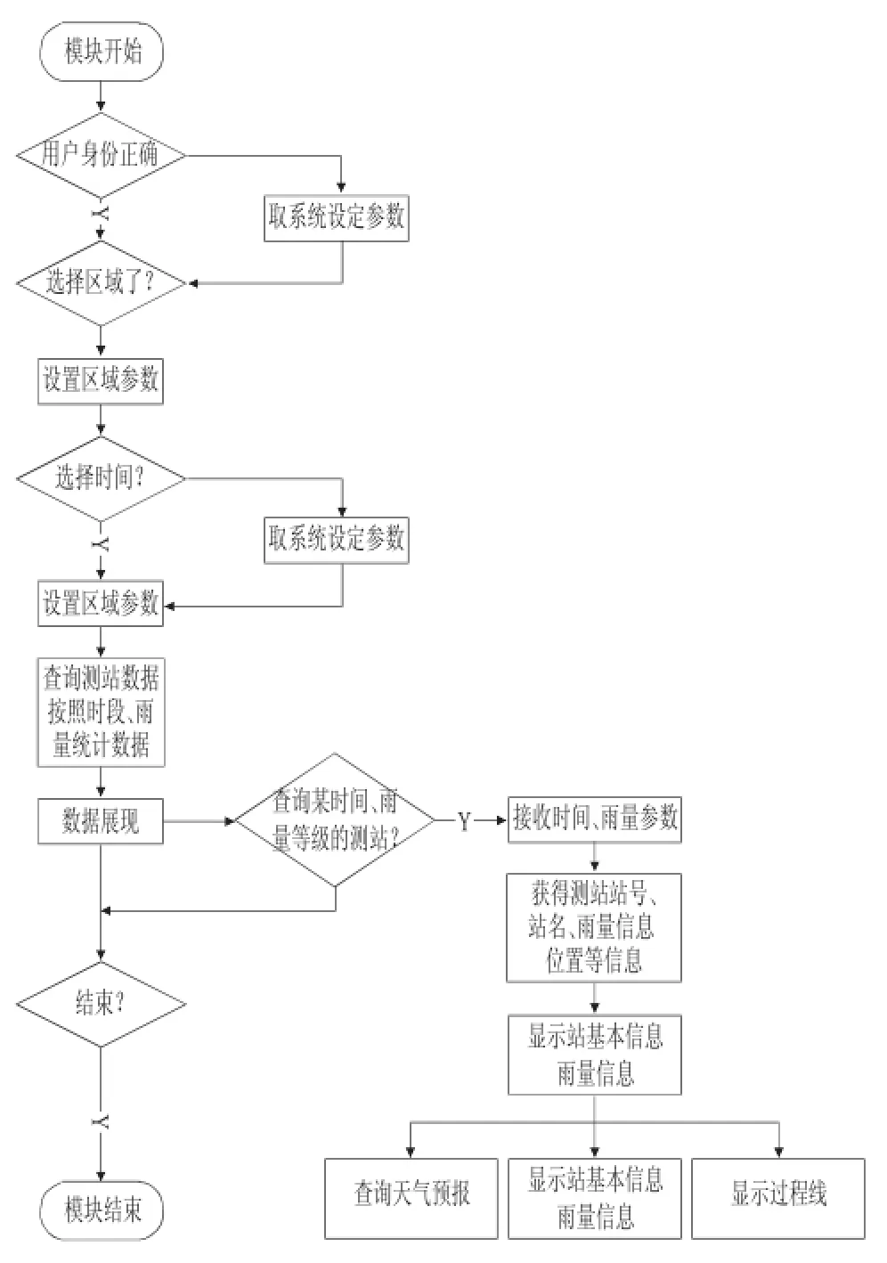
图2 雨情信息查询流程图
同时,根据各时段的降雨强度,对测站进行汇总;可以指定查询的行政区划范围或者流域范围;可以查看某个雨强所对应的降雨测站一览以及测站的7d降雨变化过程。
2)水情信息
用于统计当前处于超警状态的河道站、水库站、潮位站数量,显示超警测站的一览信息,提供最近7天的水位流量过程线。提供水情测站的详细信息的查询,在地图上对测站进行定位显示[3],并进行特定行政区域、流域的查询。
从访问方式上可以分为超警查询和普通查询。①超警测站:直接统计和显示具有超警信息的测站统计,用于聚焦热点。支持进一步查询测站详细信息、卫星定位、水位过程线等信息。②全部测站查询:针对河道站、水库站、潮位站的全量查询。支持进一步查询测站详细信息、卫星定位、水位过程线、流量过程线等信息。
3)水情简报:提供上传最新水情简报的功能,能够对不同格式的简报进行自动变换。可以根据重力感应对屏幕显示进行自适应,达到最佳显示效果。另外支持多点触摸的放大缩小。
4)气象信息:气象信息中显示最近 3d 的天气预报,24,48,72h 的数值预报。
5)卫星云图:此模块自动获取最新卫星云图,查看当前的卫星云图,可以根据重力感应对屏幕显示进行自适应,达到最佳显示效果。支持多点触摸的放大缩小。
6)台风路径:此模块可以提供最新和历史的台风信息,提供台风路径显示。查看当前太平洋上的台风路径;显示中国、日本、美国等地的预报信息;显示当前点的风圈信息;查看历史台风的详细信息。
7)测站查询:提供用户自由输入,查询测站和显示测站信息的功能。同时提供了热点测站收藏的功能,方便查询经常关注的站点。
8)通讯录:该功能用于查找防汛工作中,各级防汛相关人员的联系方式,并支持直接拨号,提高工作效率。
9)知识库:提供防汛中的一些知识资料,如河流水系、报汛站网、暴雨洪水、水库特性以及常用防汛相关知识,为日常防汛工作提供支持。
3 系统特点
系统自 2011 年 5 月末正式投入使用,经过 2年多的应用,得出以下结论。
1)先进性。软件开发采用当前最先进的软硬件开发平台,融合了数据库技术、3G 通讯技术、地理信息系统,在对目前国内水文行业实时数据采集入库的基础上,针对防汛工作中迫切需要解决的关键问题对软件系统进行了设计与开发,并对将来可能增加的新业务与数据预留接口,保证了系统的先进性。
2)实用性。充分发挥智能终端平台的大画面、操作简单、速度快、重力感应等特点。适合水利部门人员使用,便于随时随地掌握防汛信息。
3)实时性。系统实现了与辽宁实时水情数据库的动态连接,实时提取最新雨水情数据并加工处理为客户端需要的格式,各种预报信息和报警信息可实时查询。实时信息做到 5min 更新一次,基本信息 12h更新一次。
4)安全性。系统采用多用户机制,对用户进行身份验证,各用户之间相互屏蔽。在数据库安全性方面,对不同用户设定不同的权限,使数据库的各种对象得到最大限度的保护。
5)扩展性。系统具有很强的扩展性,对今后增加的信息量增加预留接口,并允许用户通过后台进行简报类型、知识库类型的扩充,便于今后根据防汛内容的变化进行调整和扩展。
4 结语
系统针对防汛水情服务需要,基于智能移动终端和地理信息技术,集水情信息的采集、传输、查询、统计、分析、预警于一体,是一套可靠性高、实时性和实用性强、安全性高的面向辽宁防汛工作的开放式业务应用系统,能让领导和广大水文、防汛工作人员随时随地了解实时水文信息,为防汛抗旱、现场指挥等提供更有效、更专用的水文信息查询服务。
[1]包健杰,李雪艳,张华峰.浅谈辽宁省防汛指挥决策支持系统建设[J].农业与技术,2006,26(6),113-116.
[2]虞开森,骆小龙,余魁.基于 Iphone 的防汛掌上通平台设计与应用[J].水利水电科技进展,2010,30(6),74-77.
[3]刑广军.雨水情自动传送系统和防汛决策系统数据共享技术的实现[J].中国水利,2008,009,45-47.
[4]赵建新.基于组件 GIS 技术在防汛指挥决策支持系统中的运用[J].江苏水利,2012,02,26-28.
[Abstract]As a clean energy,the hydropower station has the advantages of the renewable,non-polluting,the low operating cost,and so on,which could not only improve the resource utilization efficiency,but also improve econom ic efficiency significantly.The paper introduces in detail the development process,the overall design scheme,the system design and realize and application effect o f the computer automation system for the hydro power station of Baishi reservoir in Liaoning province.The study would deepen understanding to the computer automation system of the small hydropower stationsand enlarge application of the computer automation system in the smallhydropower stations.
[Key words]computer automation;Baishi reservoir;operation efficiency
Design of rubber dam in cold area
LIU Li,TANG Zhen-hua,ZHANG Da-peng
As a new type hydraulic structures,the rubber dam has the advantages of the low cost,the simple structure,the short construction period,the good seism ic resistance,the easymaintenance,the finemodeling,and so on,isw idely used in the fieldsof the gate and dam projects,the irrigation canalproject,the coastal breakwater, the urban river controland the landscape engineering athome and abroad.Combined w ith the engineering design examples,the paper explores the key technology of anti-freeze design in cold area,which could provide some reference for the sim ilar projects.
cold area;rubber dam;design;anti-freeze
Design of flocculation process of water treatment p lant in Changhai county
ZHOU Qing-chun
[Abstract]The tourism is themain development in Changhai county in future.The visitor reaches itspeak from July to September in the summer,also is the water consumption.The water consumption is relatively less in spring and autumn and least in winter.Based on the characteristicsof the water consumption,the paper discusses the design improvement of flocculation process on the basis of the traditional process for the water treatment plant,which iswelladapted to the water demand of the four seasons in Changhai county.
[Key words]water consumption;water treatment plant;folded plate flocculator;sludge discharge
App lication of wavelet hydrological analysis in annual precipitation analysis
XU Min
[Abstract]An important task of the hydrology is the medium and long term hydrological forecasting for the hydrological factors.At present,the methods of the parameter estimation,the multiple regression and linear correlation are used generally.Based on the theory of the wavelet hydrological analysis,the paper discusses the variation characteristicsof themultiple time scales of the precipitation time series and findsout the evolution and trendsof precipitation time series at the different time scales,which could provide the analysis basis for themedi um and long term forecasting of the precipitation.
[Key words]wavelet hydrologicalanalysis;time scale;precipitation
Com prehensive evaluation of water environment quality in Fuzhouhe river
TENG Yu
[Abstract]According to the water quality monitoring data from 2006 to 2009,the single factor evaluation and the comprehensive evaluation aremade for the water environment of Fuzhouhe river by using the water quality identification index method.The results of the four sections show that the water quality grades of the Songshu reservoir and the Fuzhouhe bridge sections are class Ⅱand class Ⅲ which aremeeting the water function target, the Caifangshen bridge section is the class ⅣorⅤ,and is the lower than one or two grade of the water function target.The ammonia nitrogen,petroleum and chem ical oxygen demand are themain water quality indicators to affect the water quality of Fuzhouhe river.Comparing w ith the organic pollution indexmethod,the water quality information obtained from the identification indexmethod ismore accurate and objective.
[[Key words]Fuzhouhe river;water quality evaluation;identification indexmethod
App lication discussion of low im pact development idea in overall urban p lanning of drought region
LIU Jun,LIDong-xue
[Abstract]The rational utilization of the water resources is an important issue of urban sustainable development in drought region.According to the characteristics o f the regional climatic conditions and the water resources utilization status in Jimunai county,the paper proposes that the low impact development idea are used for the design of urban water-saving project and the appropriate technicalmeans and engineering measures are adopted to improve the utilization efficiency of regional water resources and realize the optim ization and sustainable development of the urban ecologicalenvironment.
[Key words]low impact development;drought;overall urban planning;water-saving project;Jimunai county of X injiang
Analysis of variation characteristics of hydrological factor in mainstream of Hunhe river
GUO Rui
[Abstract]The paper analyzes the interannual changesof precipitation,runoff,evaporation and sediment discharge for the 4 stationsof themain stream of Hunhe river by using the linear trend estimation method and the Kendall rank correlation test.The results show that the change trends of the precipitation and the sediment discharge are not significant for the 4 stations,the change trend of the runoff is not significant for the 3 stations except that decreasing trend is the obviousat the Fushun station,the evaporation of Shenyang station has the obvious increas ing trend and the Beikouqian station no change.
[Key words]Hunhe river;hydrological factor;characteristicsanalysis
Analysis of hazards rescission of concrete dam cracks by setting work joint
SHINing-yan
[Abstract]The crack in the concrete dam is a common phenomenon.How to control,there are many research resultspublished at home and abroad,but the simple and easy operation methodsare notmuch.Based on the law and experience summary of the dam crack,the setting work jointmethod is used for some important partsof the dam,which is partly adopted the roller compacted concrete of Baishi reservoir,and then it has taken preventive effect and achieved the aim of easy construction.
[Key words]work joint;dam cracks;Baishi reservoir
App lication analysis of automation system for Baishihydropower station
WANG Ying
P338+.9
A
1002-0624(2014)04-0068-03
2013-12-11
猜你喜欢
心声歌刊(2021年4期)2021-12-02
宝藏(2021年6期)2021-07-20
宝藏(2021年4期)2021-05-27
宝藏(2021年11期)2021-01-01
学生天地(2020年25期)2020-06-01
艺术品(2020年12期)2020-04-28
电子制作(2018年23期)2018-12-26
农家科技下旬刊(2018年9期)2018-11-10
陶山(2018年2期)2018-01-23
军营文化天地(2017年10期)2017-12-05