
Characteristics of Meteorological Factors over Different Landscape Types During Dust Storm Events in Cele,Xinjiang,China
2014-12-14 06:57MAODonglei毛东雷LEIJiaqiang雷加强LIShengyu李生宇ZENGFanjiang曾凡江WANGCui王翠andZHOUJie周杰
关键词:周杰
MAO Donglei(毛东雷),LEI Jiaqiang(雷加强),LI Shengyu(李生宇),ZENG Fanjiang(曾凡江), WANG Cui,2,4(王翠),and ZHOU Jie,2,4(周杰)
1 Xinjiang Institute of Ecology and Geography,Chinese Academy of Sciences,Urumqi 830011
2 University of Chinese Academy of Sciences,Beijing 100049
3 College of Geographical Sciences and Tourism,Xinjiang Normal University,Urumqi 830054
4 Cele National Station of Observation and Research for Desert-Grassland Ecosystem in Xinjiang,Cele 848300
Characteristics of Meteorological Factors over Different Landscape Types During Dust Storm Events in Cele,Xinjiang,China
MAO Donglei1,2,3,4∗(毛东雷),LEI Jiaqiang1,4(雷加强),LI Shengyu1(李生宇),ZENG Fanjiang1,4(曾凡江), WANG Cui1,2,4(王翠),and ZHOU Jie1,2,4(周杰)
1 Xinjiang Institute of Ecology and Geography,Chinese Academy of Sciences,Urumqi 830011
2 University of Chinese Academy of Sciences,Beijing 100049
3 College of Geographical Sciences and Tourism,Xinjiang Normal University,Urumqi 830054
4 Cele National Station of Observation and Research for Desert-Grassland Ecosystem in Xinjiang,Cele 848300
Landscape characteristics influence meteorological factors,thus affect the occurrence and nature of dust storm events.The present study investigates the spatiotemporal characteristics of six meteorological factors (wind velocity,wind direction,air temperature,relative humidity(RH),photo synthetically active radiation (PAR),and solar radiation)over different landscape types(shifting-sand frontier,semi-fixed sandy land,fixed sandy land,and the inner region of an oasis)before and after dust storms during four typical dust storm events in an oasis-desert ecotone in Cele,Xinjiang,China.The results show that the average wind velocity decreased significantly from the shifting-sand frontier to the inner oasis,which was mainly attributable to the vegetation coverage.Before the dust storm events,there were obvious differences in air temperature and RH either in the horizontal or vertical direction over the different landscape types.However,these factors were very similar during and following the dust storm events.PAR and solar radiation were significantly reduced during the dust storm events and the subsequent sand-blowing and floating-dust conditions.This effect was much stronger than during similar weather conditions without dust storm events such as sand-blowing and overcast and/or rainy days.Additionally,the variation in the meteorological factors among the different landscapes was also affected by the prevailing wind direction during the dust storm events.However,the landscape type slightly changed the prevailing wind direction,with the greatest dispersion distribution of wind direction in the inner oasis.The findings of this study are helpful for understanding the function of landscape types in the occurrence of dust storms,as well as for providing a theoretical basis for prevention of dust storms.
dust storms,weather,meteorological factors,changing characteristics,Cele
1.Introduction
Dust storms are a catastrophic weather phenomenon mainly occurring in arid and semi-arid regions,in which a lot of dust is advected by strong winds and horizontal visibility is less than 1 km(Central Meteorological Bureau,1979).They are generally associated with small probability and great threat,and induced by specific large-scale circulation patterns and the development of certain weather systems.Research on weather systems that cause dust storms mainly concentrates on three aspects:weather dynamic processes,spatiotemporal distributions of dust storms and associated cause-effects,and variations of related meteorological elements.Joseph et al.(1980)reported visibility to decrease sharply,wind velocity to increase rapidly,and relative humidity to increase greatly during dust storms in India.Taha et al.(1991)pointed
out that the average wind velocity decreased by 0-2 m s-1in an oasis compared with an open field. Goudie and Middleton(1992)noted the lack of a global model describing the occurrence and frequency of dust storms.Natural processes are the main determinant in the frequency of dust storms.A wind erosion index was proposed to forecast dust storms in order to decrease wind erosion by modified wind regimes and soil moisture conditions(McTainsh et al., 1998).Desouza et al.(2011)researched evolution characteristics of a dust storm day in Oman:high wind velocity was closely correlated with a fast moving cold front driving suspended sand within a zero vegetation zone.Muhammad et al.(2012)proposed that a hybrid approach consisting of satellite imagery and wireless sensor networks is most suitable for detecting and predicting sand and dust storms of all types. Dust storms in Middle East and Southwest Asia can be grouped into two main categories:the Shamal dust storms and frontal dust storms(Hamidi et al.,2013).
Supported by the Special Major Science and Technology Projects in Xinjiang Uygur Autonomous Region(201130106-1),China Meteorological Administration Special Public Welfare Research Fund(GYHY201106025),Xinjiang Normal University Doctor of Geography Supporting Program,and Xinjiang Lake Environment and Resources Laboratory of Arid Zone(XJDX0909-2013-08).
∗Corresponding author:donglei6325@sina.com.
©The Chinese Meteorological Society and Springer-Verlag Berlin Heidelberg 2014
Research on dust storm weather in China began in the 1970s.Zhou et al.(2002)and Qian et al. (2003)concluded that the Hotan area in the southern margin of the Tarim basin is one of the high frequency centers for strong or exceptionally strong dust storms in northern China.Wang et al.(2003)pointed out that there are few dust storms in northern Xinjiang and many dust storms in southern Xinjiang,and that dust storms occurred frequently from the 1960s to 1970s,before decreasing obviously after the 1990s; they also noted that dust storms mainly appear from April to August.Liu et al.(2004)researched the fractal characteristics of strong dust storm weather systems.Bai et al.(2005)pointed out that there are two concentrated areas of dust storm events in the Tarim basin:the eastern Tarim basin,centered in the Kashgar and Artush area;and the southern Tarim basin, centered in Cele and Hotan.Meteorological factors change sharply before and after the passing of dust storms:air pressure increases,air temperature decreases,and wind velocity increases drastically(Wang et al.,2000).Lu and Liu(2006)found a close correlation between increasing vegetation cover and decreasing dust storm frequency.The vegetation coverage is considered an important factor for dust storm frequency changes in northern China.Fan et al.(2010), Zhang et al.(2010),and Hai(2011)found that the occurrence of dust storms sharply increases the relative humidity,air pressure,and wind velocity.However, Niu et al.(2007)concluded that air temperature is relatively high near the ground before dust storms, and decreases sharply over a short period after dust storms.There is a process of decreasing air temperature and increasing relative humidity in a dust storm event(Li et al.,2009).The photosynthetically active radiation(PAR)and total solar radiation during dust storm events are obviously less than on cloudy and sunny days(Yao et al.,2006;Feng et al.,2009).
Nonetheless,the above-mentioned studies mainly focused on the spatiotemporal characteristics of dust storms and associated regional background circulations;few studies have examined variations of the meteorological factors such as wind,air temperature,relative humidity,and solar radiation before,during,and after dust storm events,especially across different land surface types in an oasis-desert ecotone.This paper aims to investigate the spatiotemporal characteristics of meteorological factors over different landscape types before,during,and after typical dust storms in the oasis-desert ecotone in Cele,Xinjiang,China,and attempts to provide a research basis for the prevention of dust storms in similar environments worldwide.
2.Brief introduction to the experimental area
Cele County lies between the southern margin of Taklimakan desert and the northern Kunlun Mountain(Fig.1).It is a typical continental warm temperate zone.The area is hot and has little precipitation in summer,with long periods of sunshine and enough light and heat resources.The temperature difference between day and night is large and the highest and lowest recorded temperatures are 41.9 and-23.9℃, respectively.The annual average precipitation is 35.1 mm,and the annual potential evaporation is 2600 mm.
It is known that wind-blown sand disasters are frequently influenced by two main prevailing wind directions,namely,northwest and northeast.On average,sand-blowing weather occurs on 25.2 days per year in Cele,with a maximum of 59 days. Gales exceeding level 8 occur from 3 to 9 times annually (Zhang,1995).Disasters due to blown sand limit social and economic development in Cele County.The annual prevailing wind directions are westerly and west-northwesterly,which together occur for 62.43%-76.25%of the time,and the subordinate wind direction is northwesterly,which occurs 17.75%of the time (Yang,1990).In recent years,the annual average number of days with dust storms has been 16.5 in Cele.Dust storms mainly occur in spring and summer(Liu et al.,2009).The oasis-desert ecotone is mostly distributed in the western and northern parts of Cele County,while to the west of Old Cele River there is shifting sandy land,and to the south is Taklimakan desert.The annual average wind velocity at 2.0-m height is 2.36,1.75,1.60,and 0.96 m s-1at the sites of shifting sandy land,semi-fixed sandy land, fixed sandy land,and oasis,respectively.The average soil water content at the soil surface(0-20 cm)in the oasis-desert ecotone is very low(generally<1%).
Lin(1988)and Zu et al.(2005)identified Taklimakan desert as being located between 36°and 42°N; and from the viewpoint of the planetary wind system, the upper air circulation over the desert is mainly influenced by midlatitude westerlies.The Tarim basin is surrounded by mountains on three sides,with the Tibetan Plateau asserting a dominant impact on the circulation situation,which influences the development of the zonal circulation.During winter,easterly and westerly airflows are prevalent to the east and to the west of Keriya River in Taklimakan desert,respectively(Fig.1).
3.Experimental design for field observation and research methodology
Four weather stations were installed on different landscape types(i.e.,shifting-sand frontier,semifixed sandy land,fixed sandy land,and inner oasis) along the prevailing wind direction. Weather stations comprised of HOBO U30 meteorological surveying instruments(USA ONSET Company).The site of weather station No.1 was representative of a surface of shifting sandy land,on the surface of which the vegetation mainly comprised sparse and tall Tamarix ramosissima shrubs,a small coverage of Hexinia polydichotoma,and Halogeton. The average height of Tamarix nebkhas was from 2.0 to 3.5 m.At the site of observation station No.2,the surface vegetation mainly comprised Tamarix shrubs,Alhagi sparsifolia, and Karelinia caspica communities,and the terrain was undulating,which represented semi-fixed sandy land.The site of observation station No.3 represented fixed-sandy land;it was located at the margin of an artificial oasis,and the surface vegetation mainly comprised a comparatively flourishing A.sparsifolia community with relatively flat terrain.The site of weather observation station No.4 was representative of the oasis,in which cotton and pomegranate were planted with vegetation coverage(VC)of more than 80%.Here,the land was flat and sandy.
From site Nos.1-3,there was a natural vegetation ecotone covering a distance of 4.3 km. The three weather stations were equipped with wind cups at heights of 0.5,1.0,1.5,2.0,and 3.0 m(including a wind vane)before July 2010.Subsequently,each meteorological station was equipped with wind cups at heights of 0.5,1.0,2.0,4.0,8.0,and 10.0 m(including a wind vane).The observation parameters included wind velocity,wind direction,air temperature, relative humility(RH),PAR,and solar radiation.Air temperature and RH probes were installed at heights of 0.5 and 2.0 m,and the probes for PAR and solar radiation were installed at a height of 1.5 m.Wind velocity resolution was 0.19 m s-1,and the precisions of air temperature and RH were 0.001℃and 0.1%,respectively.The wind direction resolution was 1.4°.A measurement baseline from site Nos.1-3 in summer 2010 was designed to observe VC(by using quadrats of size 100 m×100 m)and topography.The VC increased gradually from site No.1(3%)to site No.3 (67%)(the VC at site No.2 was 27%).
The study area was located at the southern margin of Taklimakan desert,and the instantaneous impact threshold wind velocity was 5 m s-1on shifting sandy land(Chen et al.,1995;Yang et al.,2012).The surface roughness and threshold wind velocity were expected to increase with increasing VC from the shifting sandy land to the inner oasis.Temporal and spatial changes of meteorological factors three days before, during,and after dust storms were analyzed. The data collection interval was 1 min for three observation periods(13-15 May 2010,11-13 March 2011,and 31 May-2 June 2012),except for a 5-min interval from 18 to 20 March 2012,i.e.,four typical dust storms were selected.Sand blew before and after the dust storm event on 14 May 2010,but the weather was sunny and breezy before the 12 March 2011 dust storm,with sand blowing and floating dust weather after the dust storm event.There was floating dust before the dust storm on 19 March 2011,and rain and cloud afterward.The weather was overcast both before and after the dust storm on 1 June 2012.All observation times are Beijing Time(BT).
4.Spatiotemporal characteristics of meteorological factors during typical dust storms
4.1 Meteorological factors duringthe13-15 May 2010 dust storm event
From nighttime of 13 May to daytime of 14 May, there occurred intermittent blowing sand over the shifting sandy land and there was some wind-blown sand on the surfaces of semi-fixed and fixed sandy land.Average wind velocity decreased substantially with increasing VC.Compared with that on the shifting sandy land of site No.1,the average wind velocity at heights of 0.5 and 2.0 m was reduced by 17.63%and 29.35%at site No.2,and 58.83%and 54.7%at site No. 3,respectively.The wind-blown sand with the highest intensity and frequency occurred at the shifting sandy land site from 0930 BT 14 May,when the dust storm began to blow up(Figs.2a and 2b).During the dust storm,the average wind velocity at heights of 0.5 and 2.0 m was reduced by 24.05%and 29.09%at site No.2,and 64.52%and 39.84%at site No.3,respectively,compared with that for the shifting sandy land of site No.1.The sand blowing continued for 217 min at site No.1.Wind power began to wane after 1930 BT 14 May until 0030 BT,and then it began to strengthen again and blowing sand appeared. Compared with that of site No.1,the average wind velocity at heights of 0.5 and 2.0 m was reduced by 25.89%and 29.22%at site No.2,and 66.92%and 42.87%at site No.3 on 15 May,respectively.

Fig.2.Changes in meteorological factors over the three landscape types(Nos.1-3)of the ecotone between 13 and 15 May 2010:(a)wind velocity at 0.5 m,(b)wind velocity at 2.0 m,(c)air temperature at 2.0 m,(d)RH at 2.0 m,(e) PAR,and(f)solar radiation.
Before the occurrence of the dust storm on 13 May,air temperature decreased and RH increased.Air temperature decreased with intermittent rainfall from 0000 BT to dawn on 13 May,and RH began to increase significantly until the morning of 13 May.In the daytime between 13 and 14 May,the order of RH values by site was No.1>No.2>No.3,and showed an opposite trend at nighttime.The differences in air temperature and RH were larger in the daytime than at nighttime,regardless of the landscape type(Figs. 2c and 2d).During the dust storm between 1400 and 1900 BT 14 May,RH declined,while PAR,air temperature,and solar radiation first significantly increased, and then weakened(Figs.2e and 2f).This is ascribed to the decreased wind power after 1250 BT and the dramatic increase in dust concentration,which reduced the solar radiation absorption and increased its scattering,diffusion,and fluctuation.Later on,with the increase of wind velocity,temperature and solar radiation increased gradually once again,and the RH decreased gradually.Before and after the dust storm, air temperature during the daytime ordered by site was No.3>No.2>No.1.This was due to the natural vegetation,which increasingly acted to prevent wind and block sand from the shifting sandy land to the oasis along the prevailing wind direction.With the decreased dust concentration toward the inner oasis,the air temperature,PAR,and solar radiation increased.The prevailing wind direction over the three landscape types was all in a W and WNW direction; however,the wind direction was more variable closer to the oasis and more wind was in an E and S direction(Fig.3).This could be ascribed to the influence of nebkhas.

Fig.3.Spatial and temporal differences of wind direction for three landscape types(Nos.1-3)between 13 and 15 May 2010.
Air temperature first increased and then decreased over the three landscape types before and after the dust storm,while RH decreased throughout the event.Temperature and RH at site Nos.1-3 on 13 May were 20.471,20.575,and 20.472℃,and 38.79%, 38.15%,and 38.75%,respectively.Air temperature and RH at site Nos.1-3 during the dust storm on 14 May were 24.144,24.569,and 24.937℃,and 24.54%, 23.93%,and 23.41%,respectively.Average air temperature gradually increased and RH gradually decreased from the shifting sandy land to the oasis;however, air temperature and RH differences between the three landscape types were very small.Air temperature and RH at site Nos.1-3 during blowing-sand weather on 15 May were 21.221,21.154,and 21.082℃,and 17.9%, 18.24%,and 18.67%,respectively.Average air temperature decreased and RH increased gradually from the shifting sandy land to the fixed sandy land,and the variation reduced.VC had a slight influence on air temperature and RH during the dust storm,while the distribution of dust concentration played a key role in changing air temperature,RH,and solar radiation.There was a consistent decreasing trend in the changes of PAR and solar radiation from the shifting sandy land to the oasis(Figs.2e and 2f).The maximum PAR and solar radiation occurred on the semifixed sandy land before the dust storm on 14 May, followed by the shifting sandy land and fixed sandy land.During the blowing-sand day(15 May),PAR and solar radiation ordered by landscape type was: shifting sandy land>semi-fixed sandy land>fixed sandy land.This indicates that higher terrain and nebkhas on semi-fixed sandy land is able to intercept, to an extent,blowing sand and floating dust.
4.2 Meteorological analysis during the 11-13 March 2011 dust storm event
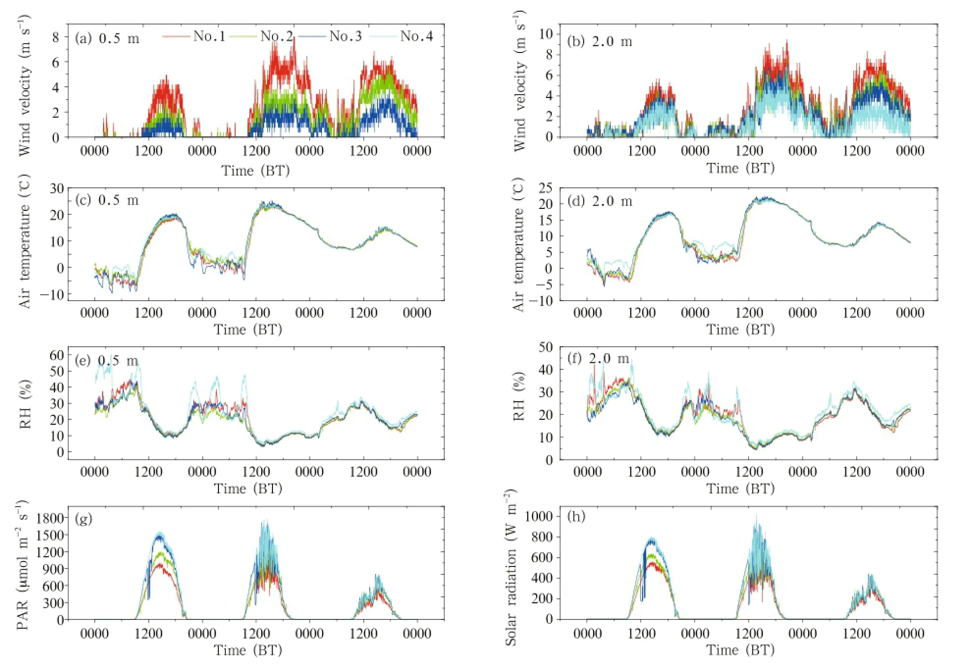
Fig.4.Changes in meteorological factors over the four landscape types(Nos.1-4)between 11 and 13 March 2011:(a) wind velocity at 0.5 m,(b)wind velocity at 2.0 m,(c)air temperature at 0.5 m,(d)air temperature at 2.0 m,(e)RH at 0.5 m,(f)RH at 2.0 m,(g)PAR,and(h)solar radiation.
The duration of blowing sand was 400 min on shifting sandy land for the dust storm on 12 March 2011.The maximum wind velocity was 11.69 m s-1at 10.0-m height.Average wind velocity and sand blowing time decreased significantly from the shifting sandy land to the semi-fixed sandy land,fixed sandy land,and oasis;there was little wind-blown sand observed at the oasis(Figs.4a and 4b).The average wind velocity over the semi-fixed sandy land, fixed sandy land,and oasis was decreased by 29.92%, 29.01%,and 44.46%,respectively,compared with that of 6.432 m s-1over the shifting sandy land.Air temperature and RH differences between the four landscape types were significant for the first two nights before the dust storm event.During the daytime for the dust storm,or blowing sand,or floating dust event, air temperature and RH over the four landscape types were changing synchronously,with no obvious differences between them.The RH difference was larger than the air temperature difference in the horizontal direction(Figs.4c-f).Air temperature increased gradually and RH decreased in order of observation site number through the oasis-desert ecotone,then increased at the oasis from site Nos.1-4.However,the difference was generally not obvious.Average air temperature at 2.0-m height on the semi-fixed sandy land, fixed sandy land,and oasis increased by 3.96%,4.9%, and 9.56%,respectively;while average RH decreased by 2.84%and 4.18%,and increased by 8.21%,respectively,as compared with the shifting sandy land where air temperature and RH were 9.396℃and 19.37%.

Fig.5.Wind direction distributions for the four landscape types(Nos.1-4)during 11-13 March 2011.
Both PAR and solar radiation for the four landscape types on every day over the three days showed increasing trends.Values started at 8.74×10⁵, 1.076×106,1.255×106,and 1.365×10⁶µmol m-2s-1and 5.228×105,6.017×105,6.748×105,7.232×105W m-2for the shifting sandy land,semi-fixed sandy land,fixed sandy land,and oasis,respectively.For the semi-fixed sandy land,fixed sandy land,and oasis,these values increased,respectively,by 23.19%, 43.62%,and 56.23%for PAR,and by 15.09%,29.06%, and 38.33%for solar radiation,compared with the values for shifting sandy land.Feng et al.(2006)and Yao et al.(2006)reported daily values of PAR during dust storm,overcast and rainy,and sunny days to be 4.09, 12.4,and 21.4 MJ m-2,respectively.PAR research at Chaganmaodao feed base in Ejin Banner showed that PAR on a sunny day was greatest,whilst PAR on an overcast and rainy day was secondary,and PAR on a dust storm day was least.However,in the present study,the value of PAR and solar radiation during blowing-sand and floating-dust weather on 13 March was least among the three days,which accounted for the fact that intermittent blowing-sand and floatingdust weather after the dust storm had a further weakening effect on PAR and solar radiation,which was far greater than during the dust storm and blowing-sand weather.The sand-blown wind direction was mainly concentrated in an SE and NE direction,and there was no obvious difference between them.When wind was blown from the oasis to desert with decreasing VC, sand and dust would be blown up easily and the dust concentration would be higher in the air when it was closer to bare shifting sandy land,leading to a greater reduction in PAR and solar radiation.Average temperature,RH,and solar radiation gradually increased from the shifting sandy land to the oasis during and after a dust storm event;these trends were the reverse of those observed on a sunny day.
4.3 Meteorological factors during the 18-20 March 2012 dust storm event
Fig.6.As in Fig.4,but for 18-20 March 2012.
The dust storm event lasted 23.5 h from 2310 BT 19 to 2240 BT 20 March 2012(according to the time of sand-blowing wind on the shifting sandy land),and was accompanied by gales and intermittent rainfall in later periods of the event.The wind velocity at heights of 0.5 m and 2.0 m weakened from the shifting sandy land to the oasis over the four landscape types,and the degree of weakening at 0.5 m was significantly greater than that at 2.0 m(Figs.6a and 6b).During the dust storm,average wind velocity at 2.0 m over the semi-fixed sandy land,fixed sandy land,and oasis was, respectively,24.65%,28.76%,and 48.73% less than that of the 5.56 m s-1over the shifting sandy land. Average air temperature and RH at 2.0-m height from the shifting sandy land to the oasis was 7.606,7.578, 7.61,and 7.47℃,and 57.98%,58.48%,57.73%,and 60.51%,respectively,all of which were very close(Figs. 6c-f).Air temperature and RH differences at nighttime between the four landscape types between 18 and 19 March were relatively significant.Values of PAR and solar radiation over the semi-fixed sandy land were greatest,followed by the shifting sandy land,fixed sandy land,and oasis,in that order(Figs.6g and 6h).During the dust storm,tall rough terrain and high density nebkhas on the semi-fixed sandy land intercepted more blowing sand and floating dust from wind-drift sand,which increased absorption of PAR and solar radiation.The weakening effect on PAR and solar radiation during gale and rain conditions on 19 March was also relatively significant,but less than during the dust storm and blowing-dust weather.
The main prevailing wind direction was WNW and E for the four landscape types during the dust storm and there was little change of wind direction spatially,though the direction was more southerly at the oasis site.
4.4 Meteorological factors during the 31 May-2 June 2012 dust storm
A dust storm occurred on 1 June 2012,during which the maximum wind velocity was 15.77 m s-1at a height of 10 m over the shifting sandy land frontier,and the dust storm duration was 19 h from 0103 to 2006 BT 1 June 2012.From the shifting sandy land frontier to the oasis,the wind velocity at different heights was reduced greatly,especially in the oasis where there was almost no sand-driving wind(Figs.8a and 8b).Average wind velocity at 2.0-m height over the semi-fixed sandy land,fixed sandy land,and oasis was reduced by 21.08%,35.72%,and 82.21%,respec-
tively,as compared with the 7.644 m s-1over the shifting sandy land site during the dust storm event. Average wind velocity at a height of 0.5 m for the shifting sandy land to the oasis margin sites was 6.52,1.45, and 1.63 m s-1,respectively,which demonstrates the weakening effect on the wind of the natural vegetation in the oasis-desert ecotone,and of the shelter forests in the oasis in summer.
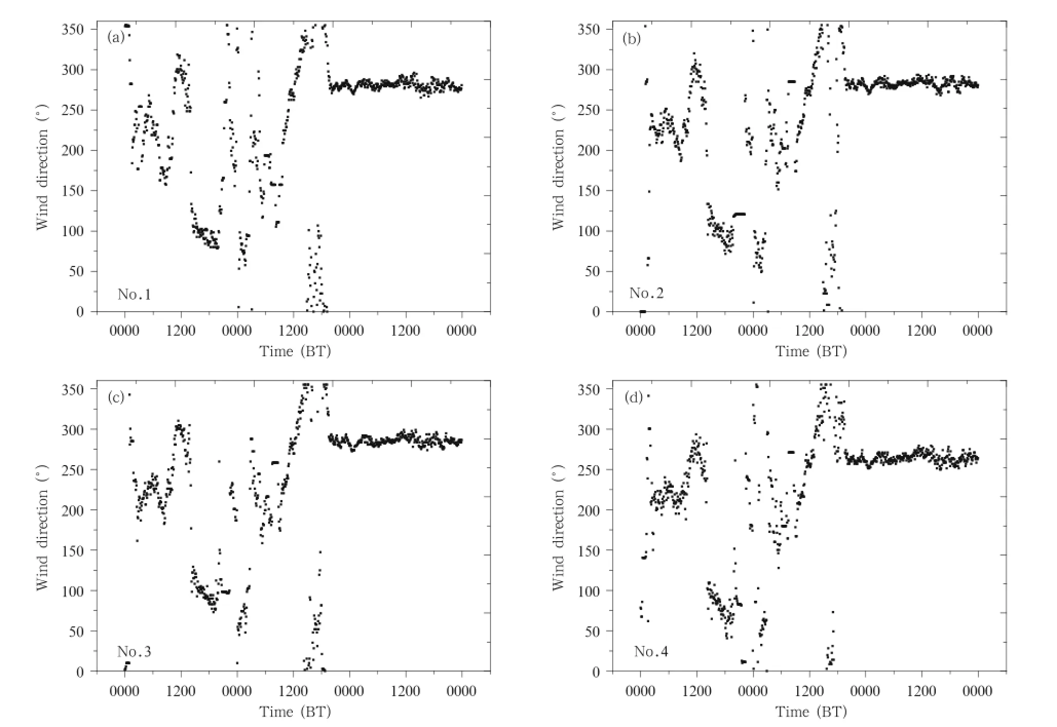
Fig.7.As in Fig.5,but for 18-20 March 2012.
There was a pattern of rainfall and sharp decline of air temperature over the four landscape types after the dust storm event.The air temperature began to slowly recover on 2 June and the biggest drop was 13℃.Air temperature differences between the three landscape types in the oasis-desert ecotone between the night and morning were more than those in the period from afternoon to sunset,and there were no significant differences between them.However,especially during night and morning periods,temperature differences between the oasis-desert ecotone and the oasis were more obvious.Air temperature in the oasis was constantly lower than that in the oasis-desert ecotone after the end of the dust storm,and this was shown during the daytime of 2 June.RH differences between the four landscape types during and after the dust storm event were less than those before the dust storm (Figs.8c-f).Average daily air temperature and RH at 2.0-m height from the shifting sandy land to oasis sites on 31 May were 27.624,27.551,27.31,and 24.799℃, and 20.77%,21.53%,23.12%,and 41.04%,respectively;on 1 June,they were 22.849,22.754,22.586,and 21.232℃,and 37.96%,38.76%,39.03%,and 48.39%, respectively;and on 2 June,they were 19.985,20.143, 19.767,and 18.747℃,and 53.19%,52.13%,54.35%, and 65.74%,respectively.Air temperature gradually decreased and RH gradually increased from the shifting sandy land to the oasis sites before and during the
dust storm.Air temperature was highest and RH was least over the semi-fixed sandy land during cloudy weather on 2 June.
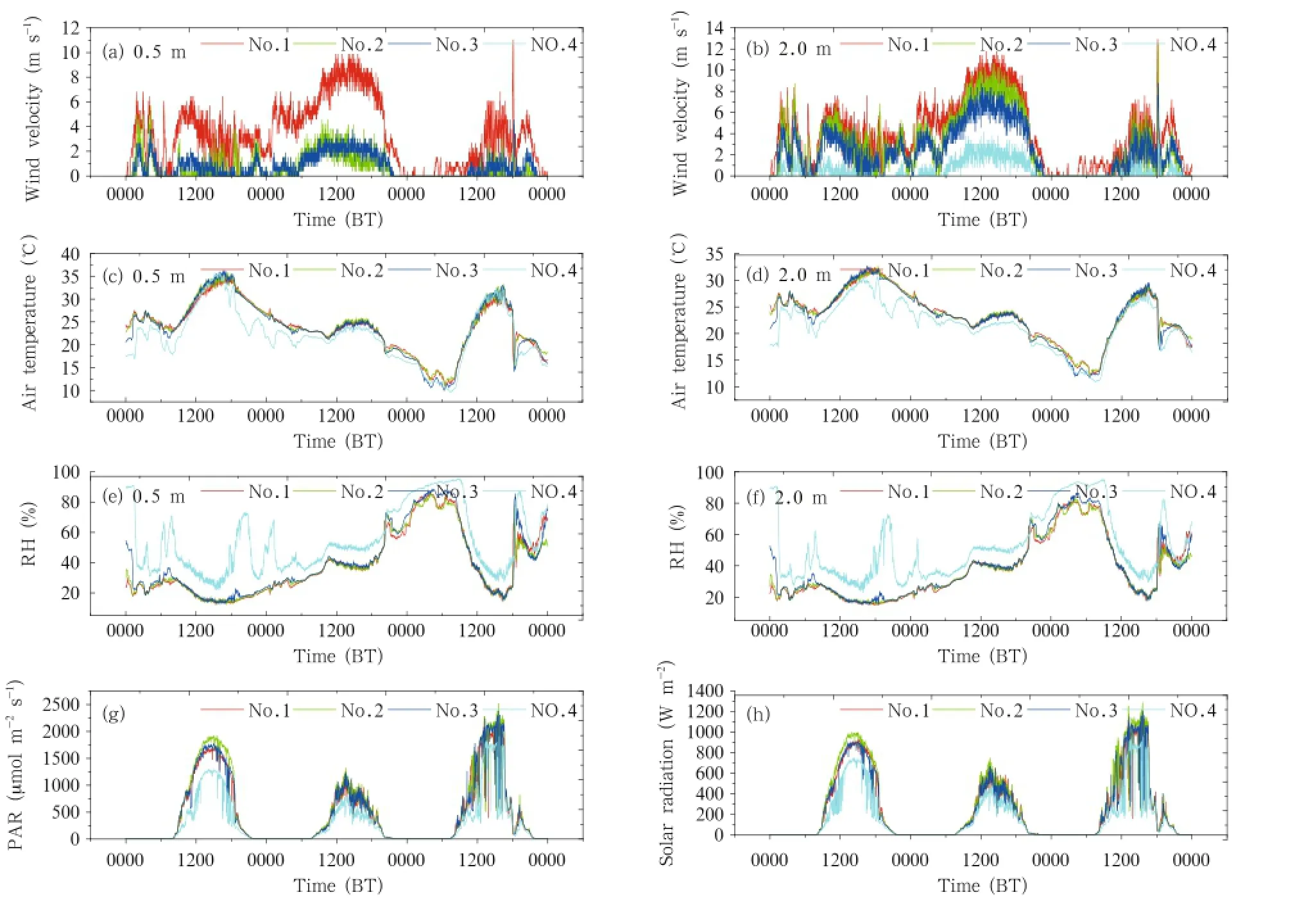
Fig.8.As in Fig.4,but for 31 May to 2 June 2012.
PAR and solar radiation for the four landscape types on 1 June were at their lowest among the three days,due to the weakening effect on PAR and solar radiation during the dust storm and blowing-sand weather compared to cloudy weather.Over the three days,PAR and solar radiation were greatest over the semi-fixed sandy land,and decreased sequentially over site Nos.3,1,and 4(Figs.8g and 8h).The average daily values of PAR and solar radiation over the semifixed sandy land on 1 June were 288.341µmol m-2s-1and 163.128 W m-2respectively;these were reduced by 4.99%,6.95%,and 39.08%,and by 4.03%,10%,and 33.2%over the shifting sandy land,fixed sandy land, and oasis,respectively.
The prevailing wind direction of wind-driven sand wind for the four landscape types was W and WNW. There were no obvious differences on the whole in wind direction distribution,but wind variability was slightly increased at the oasis site(Fig.9).

Fig.9.As in Fig.5,but for 31 May to 2 June 2012.
During the last three dust storms,the temperature and RH difference in the vertical direction at night for all four landscape types was obviously greater than during daytime.At all sites at night,air temperature at 2.0-m height was higher than that at 0.5 m,indicating a temperature inversion layer.Air temperature at 2.0 m was lower than that at 0.5 m in the daytime and the RH changes in the vertical direction showed an opposite trend(Fig.10). This is because the ground surface continuously receives heat in the daytime and the air temperature increases quickly near the surface;the surface loses heat quickly at nighttime and part of the heat that is lost is stored in the atmosphere,including at the 2.0-m height.The air temperature difference in the vertical direction at night in spring over the fixed sandy land near the oasis was significantly greater than that at the other three observation stations,while in the daytime at the oasis it was greater than that in the oasis-desert ecotone. The air temperature difference in the vertical direction in the oasis before and during the dust storm events in summer showed the greatest value;however,air temperature and RH differences in the vertical direction between the four landscape types during and after the dust storms both in the daytime and at night were very close(Fig.10).Air temperature and RH differences in the vertical direction were largest at site No.3. The RH difference in the vertical direction at the oasis was greatest before the dust storm and was greater than that at other sites.This indicates that heat and vapor near the surface before the dust storm were continuously exchanging and migrating;furthermore,the moisture-heat exchange on the fixed sandy land beside the oasis was largest in spring.At the border between the oasis and the oasis-desert ecotone,there was an influence from the uptake of adhered condensational water by ungerminated vegetation and plant absorption of solar radiation.Large vertical changes helped to form natural channels for water and heat transfer in the horizontal direction.Before the dust storms,atmospheric stratification was very unstable and water and heat were exchanged frequently;however,atmospheric stratification near the surface became relatively stable during or after the dust storm events.
4.5 Differences in average wind velocity profiles for varying landscape types during dust storm events

Fig.10.Air temperature and RH changes in the vertical direction for the four landscape types(Nos.1-4)during the three dust storms.
Across the four dust storm events,average wind velocity reached a maximum on 1 June 2012.When average wind velocity were comparatively smaller,all wind profiles primarily fitted a logarithmic correlation on 14 May 2010 and 12 March 2011,and most wind profiles did not fit a logarithmic correlation when the average wind velocity were stronger in the dust storm events on 19 March and 1 June 2012.Wind velocity near the ground surface was reduced when wind approached or entered the oasis.The slopes of wind profiles under 4.0 m became reduced from the shifting sandy land frontier to the oasis;wind velocity differences near the ground surface in the vertical direction were greater than those at 4.0-m height;and wind velocity vertical profiles over 4.0 m were close to a linear
distribution(Fig.11).Wind velocity at a height of 2.0 m was greater than that at a height of 4.0 m at site No.3 on 19 March 2012,and this may be due to strong winds near the oasis edge as a result of the buffering effect of shelter-forests,causing strengthened turbulence.
5.Conclusions and discussion
The present results show that temperature and RH differences among four landscape types were relatively small during dust storm events.However,they were relatively large before dust storm occurrence,and this was related to invasion by cold,high-pressure airflow.Significant differences in temperature and RH between the desert area and oasis provide an important basis for dust storm prevention and mitigation.In future,to accurately predict and prevent dust storms for oasis farmland maintenance,ground temperature, latent heat flux,and air pressure over different landscape types should be observed to further reveal the spatial variability of meteorological factors during dust storm events.
The present research also shows that VC,wind velocity,wind direction,and topography were main factors influencing the spatial differences during the dust storm events between the oasis-desert ecotone and the oasis,and that the vegetation distribution was the most important factor(Qian et al.,2004). Chen and Zhou(2010)pointed out that local VC and soil factors are also key factors besides topography, wind velocity,wind direction,and atmospheric stability in influencing the occurrence and migration of dust storms.Through quantitative analysis between
normalized difference vegetation index(NDVI)and aerosol index,a significant negative relationship between them was demonstrated,indicating that the existence of vegetation can restrain floating-dust occurrence to a certain extent.
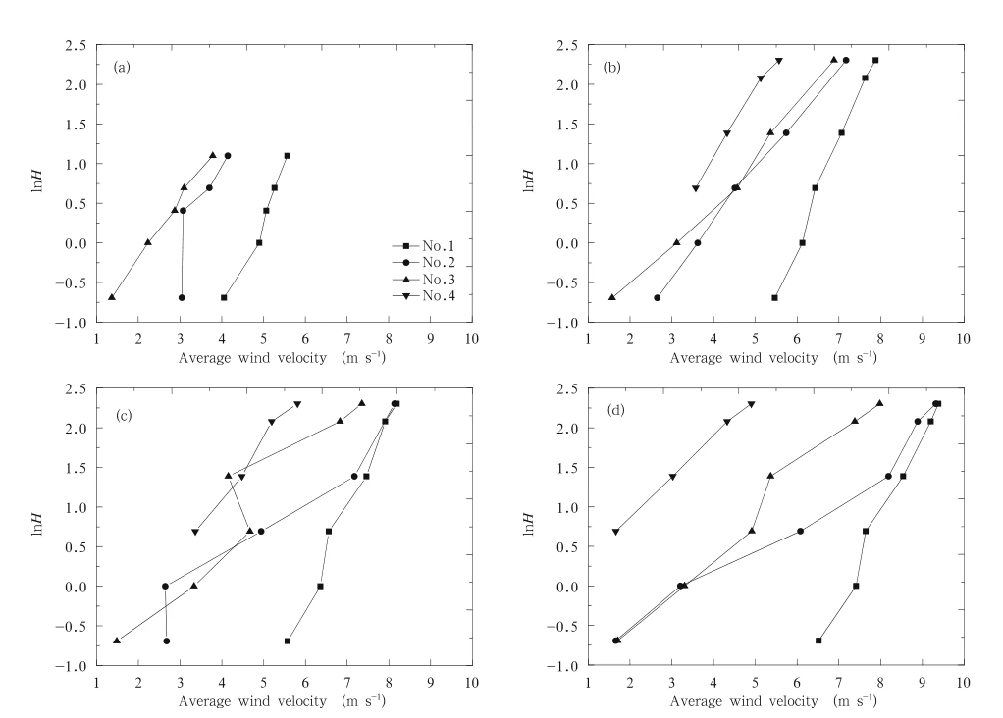
Fig.11.Average wind velocity profiles for varying landscape types(Nos.1-4)during four dust storm events:(a)14 May 2010,(b)12 March 2011,(c)19 March 2012,and(d)1 June 2012.
In spring,vegetation has not yet fully emerged and soil moisture is extremely low in the Cele area. Dust storms can cause blown-sand hazards,and influence the safety of transportation and electric power industries,thereby damaging human health.Meanwhile,they also affect plant photosynthesis,which can influence growth of natural vegetation and crop yields.Therefore,only through improving soil moisture conditions,increasing VC,banning unauthorized logging,overgrazing,and abuse of reclamation,can the damage caused by sand storm events to oases be effectively prevented and reduced.In summary,we draw the following conclusions from the present work.
(1)Average wind velocity gradually decreased with increasing VC from the shifting sandy land frontier to the oasis,with the maximum decrease in the inner oasis. During the dust storms,natural vegetation in the oasis-desert ecotone demonstrated a buffering effect on the wind and an interception of blown sand.It was more effective at these processes in summer than in spring.
(2)During dust storm events,differences in air temperature and RH were small between the oasisdesert ecotone and the inner oasis.Air temperature increased and RH decreased gradually,and PAR and solar radiation increased significantly from the shifting sandy land frontier to the oasis.When the prevailing wind direction was E and SES,PAR and solar radiation were significantly reduced during the dust storm events and the subsequent sand-blowing and floating-dust conditions,and this effect was much stronger than for similar weather conditions without dust storm events such as sand-blowing and overcast and/or rainy days.
(3)Air temperature,PAR,and solar radiation showed their greatest values over the semi-fixed sandy land when the prevailing wind direction was W and WNW during dust storm events.Values at the other sites decreased in the following order:shifting sandy land,semi-fixed sandy land,and oasis.This could be attributed to the high sun angle and more interception of blown sand and dust by the high terrain of the semi-fixed sandy land.
(4)RH differences among the four landscape types during the dust storms in summer were more than those in spring,which was caused by higher VC and the irrigation effect of the oasis.Air temperature and RH differences among the four landscape types were very small both in the horizontal and vertical directions;however,the differences increased abruptly before dust storm occurrence.
(5)The distribution of wind direction for the four landscape types changed very little during the dust storm events in summer;however,the prevailing wind direction was more varied when wind entered the oasis.
Acknowledgment.The anonymous reviewers are thanked for their valuable comments and suggestions.
Bai Yungang,Song Yudong,Zhang Jianjun,et al.,2005: Spatialtemporal distribution of sandstorm weather trend in Tarim basin in recent 40 years.J.Arid Land Resour.Environ.,19,42-45.(in Chinese)
Central Meteorological Bureau,1979:Specification for Ground Meteorological Observation.China Meteorological Press,Beijing,21-27.(in Chinese)
Chen Weinan,Dong Zhaibao,Yang Zuotao,et al.,1995: Threshold velocities of sand-driving wind in the Taklimakan desert.Acta Geographica Sinica,50, 360-367.(in Chinese)
Chen Zhigang and Zhou Jianhua,2010:NDVI and the conditions of generating sandstorm.Ecology Environ.Sci.,19,870-876.(in Chinese)
Desouza,N.D.,B.Simon,and S.M.Qureshi,2011:Evolutionary characteristics of a dust storm over Oman on 2 February 2008.Meteor.Atmos.Phys.,114, 107-121.
Fan Da,Shi Peijun,and Liu Sanchao,2010:Relationship between dust storm disaster and vegetation fraction in northern China.J.Nat.Disasters,19,1-7.(in Chinese)
Feng Qi,Si Jianhua,Zhang Yanwu,et al.,2006:Microclimatic characteristics of the Heihe oasis in the
hyperarid zone.J.Geograph.Sci.,16,33-44.(in Chinese)
—-,Zhou Macuo,and Xi Haiyang,2009:Analysis of an oasis microclimate in China’s hyperarid zone.Environ.Geol.,58,963-972.
Goudie,A.S.,and N.J.Middleton,1992:The changing frequency of dust storms through time. Climate Change,20,197-225.
Hai Xianlian,2011:Contrast analysis of surface meteorological element during twice powerful sandstorm processes in 2010.J.Arid Land Resour.Environ., 25,104-108.(in Chinese)
Hamidi,M.,M.R.Kavianpour,and Y.P.Shao,2013: Synoptic analysis of dust storms in the Middle East. Asia-Pacific J.Atmos.Sci.,49,279-286.
Joseph,P.V.,D.K.Raipal,and S.N.Deka,1980:“Andhi”,the convective dust storms of Northwest India.Mausam,31,431-442.
Li Xiangyu,He Qing,Huang Shaopeng,et al.,2009: Characteristics of meteorological factors in the surface layer before and after a severe sandstorm in the Taklimakan desert hinterland,southern Xinjiang, China.Plateau Meteor.,28,652-662.(in Chinese)
Lin Yuquan,1988:The flow field characteristics and its relation to the intensity of drifting sand activity in Taklimakan desert.J.Desert Res.,8,25-37.(in Chinese)
Liu Haitao,Zhang Xiangjun,Li Yingkui,et al.,2009: The time-space distribution characteristics of sand storm weather in Hotan region.J.Arid Land Resour.Environ.,23,85-89.(in Chinese)
Liu Jingtao,Qian Zhengan,Jiang Xuegong,et al.,2004: A study on weather types of super severe dust storms in North China.Plateau Meteor.,23,540-547.(in Chinese)
Lu Zheng and Liu Couhua,2006:On the relationship between sandstorm and meteorological factors in China.Meteor.Mon.,32,35-41.(in Chinese)
McTainsh,G.H.,A.W.Lynch,and E.K.Tews,1998: Climatic controls upon dust storm occurrence in eastern Australia.J.Arid Environ.,39,457-466.
Muhammad,A.,T.R.Sheltami,and H.T.Mouftah, 2012:A review of techniques and technologies for sand and dust storm detection.Rev.Environ.Sci. Biotechnol.,11,305-322.
Niu Shengjie,Yue Ping,and Liu Xiaoyun,2007:Variations of surface meteorological element during twice dust storms passing Jiuquan on 28 March and 12 July 2004.J.Desert Res.,27,1067-1071.(in Chinese)
Qian Yibing,Wu Zhaoning,Zhang Liyun,et al.,2004: Ground-surface conditions resulting in dust storms in the south Junggar basin.Arid Land Geography, 27,540-542.(in Chinese)
Qian Zhengan,Cai Ying,Liu Jingtao,et al.,2003:Some progresses and problems in research of dust storms in northern China.Annual Conference of Chinese Meteorological Society in December 2002,Chinese Meteorological Society,Beijing,254-258.(in Chinese)
Taha,H.,H.Akbari,and A.Rosenfeld,1991:Heat island and oasis effects of vegetative canopies:Micrometeorological field-measurements. Theor. Appl. Climatol.,44,123-138.
Wang Shigong,Dong Guangrong,Chen Huizhong,et al., 2000:Advances in studying sand-dust storms of China.J.Desert Res.,20,349-356.(in Chinese)
Wang Xu,Ma Yu,and Chen Hongwu,2003:Climate characteristics of sandstorm in Xinjiang.J.Desert Res.,23,539-544.(in Chinese)
Yang Xinhua,He Qing,Huo Wen,et al.,2012:Sand saltation in the southern margin of the Taklamakan desert—A case study on Cele County.J.Desert Res.,32,910-914.(in Chinese)
Yang Zuotao,1990:Relationship of wind direction and wind velocity between the Gobi desert and oasis:A case study on Cele County in Xinjiang.J.Desert Res.,10,33-39.(in Chinese)
Yao Jimin,Gao Xiaoqing,Feng Qi,et al.,2006:The photosynthetically active radiation during dust storm day in Ejina oasis.Acta Energiae Solaris Sinica,27, 484-488.(in Chinese)
Zhang Henian,1995:Research of synthetic renovation technology and experiment demonstration in ecological environmental area in ecotone in the south of Taklamakan.Arid Zone Res.,12,1-9.(in Chinese)
Zhang Tairen,Chai Xiumei,and Li Zizhen,2010:Characteristics of vegetation coverage in northern China and its relationship with sandstorm.Plateau Meteor.,29,137-145.(in Chinese)
Zhou Zijiang,Wang Xiwen,and Niu Ruoyun,2002:Climate characteristics of sandstorm in China in recent 47 years.J.Appl.Meteor.Sci.,13,193-200.(in Chinese)
Zu Ruiping,Zhang Kecun,Qu Jianjun,et al.,2005:Characteristics of surface winds in Taklimakan deserts and their relationship to the orientation of dunes in neighboring regions.J.Appl.Meteor.Sci.,16, 468-475.(in Chinese)
:Mao Donglei,Lei Jiaqiang,Li Shengyu,et al.,2014:Characteristics of meteorological factors over different landscape types during dust storm events in Cele,Xinjiang,China.J.Meteor.Res., 28(4),576-591,
10.1007/s13351-014-3097-4.
(Received November 9,2013;in final form May 22,2014)
猜你喜欢
Chinese Physics B(2022年5期)2022-05-16
考试与评价·八年级版(2020年3期)2020-11-02
作文与考试·初中版(2016年14期)2016-05-26
中国新闻周刊(2016年6期)2016-02-26
中国法治文化(2016年9期)2016-02-10
博客天下(2016年1期)2016-01-14
东方艺术·大家(2015年10期)2015-11-09
投资与理财(2014年10期)2014-05-21
南都娱乐周刊(2009年26期)2009-10-29
青年文摘·上半月(1995年1期)1995-01-01
 Journal of Meteorological Research2014年4期
- Journal of Meteorological Research的其它文章
- Chinese Contribution to CMIP5:An Overview of Five Chinese Models’Performances
- Track of Super Typhoon Haiyan Predicted by a Typhoon Model for the South China Sea
- Variations in Regional Mean Daily Precipitation Extremes and Related Circulation Anomalies over Central China During Boreal Summer
- The Persistent Heavy Rainfall over Southern China in June 2010: Evolution of Synoptic Systems and the Effects of the Tibetan Plateau Heating
- Overview of the Major 2012-2013 Northern Hemisphere Stratospheric Sudden Warming:Evolution and Its Association with Surface Weather
- Diagnostic Study of Global Energy Cycle of the GRAPES Global Model in the Mixed Space-Time Domain