
Preliminary evidence for 17 coastal terraces on Fildes Peninsula,King George Island, Antarctica
2015-02-06 07:24CHUZhudingYINXuebinSUNLiguangWANGYuhong
Advances in Polar Science 2015年1期
CHU Zhuding, YIN Xuebin, SUN Liguang.* & WANG Yuhong
Institute of Polar Environment, School of Earth and Space Sciences, University of Science and Technology of China, Hefei 230026, China
1 Introduction
Coastal terraces have been described and studied comparatively in Antarctica, and linked with isostatic uplift and sea level change[1-6]. Mashacher[7]discovered marine plants, shells, and animal bone at 18 m and 24 m ASL in Zhenzhu Stream Valley on Fildes Peninsula. Li and Zhang[8]and Li et al.[9]confirmed the presence of neritic deposits in the valleys of Xisi River on the peninsula based on paleontology and grain size analysis. Yang and Chen[10]analyzed diatom fossils from Yanou Lake on Fildes Peninsula, and confirmed it as a neritic environment during the Quaternary. In their work, Xie and Cui[11]discussed the environmental implications of the platform on King George Island and five coastal terraces have been discovered on Fildes Peninsula[12-14]. In this paper, based on field observations and grain size analysis of the sediment, we report 17 coastal terraces on Fildes Peninsula.
2 Study area and methods
2.1 Fildes Peninsula
Fildes Peninsula (62°08′48″-62°14′02″S, 58°53′40″-59°01′50″W) is 10 km long, 2.5-4 km wide, and covers an area of 30 km2. It is the largest ice-free area with approximately 20 ka years of history on King George Island(Figure 1)[8]. The highest mountain is Horatio Stump at 164.3 m ASL. The tertiary volcanic rocks on the peninsula are mainly high-Al basalt and basaltic andesite, as well as andesite and dacite[15]. The basaltic-andesitic lavas that make up most of the peninsula, the thin-layered pyroclasticsedimentary fossil-bearing strata, subvolcanic intrusions,and dykes from different effusive periods show that tertiary volcanic activity has continued to the present on the Antarctic Peninsula[16-17].
Fildes Peninsula has two major landforms: mountains mainly consisting of bedrock over 50 m ASL, and rising coastal terraces. Both landforms have been eroded by glaciers. The five coastal terraces mainly contain loose gravel sand deposits on the east coast, and the fifth level is a highly developed abrasion terrace at 40-50 m ASL[5,12-13].The weathering rate on the peninsula ranges from 0.012 to 2.041 mm.a-1, with an average rate of approximately 0.200 mm·a-1. The planar denudation rate ranges from 28.94 to 4 940.45 g·m-2·a-1, with an average rate of approximately 552.13 g·m-2·a-1[8]. A prolonged lack of much surface runoff has greatly lowered the migration rates of terrestrial material and shortened the transmission distance, resulting in deposition near the origins. Strong physical and relatively weak biochemical processes have led to the formation of a thin pedosphere, including frozen entisol, humid frozen cambisol, normal frozen cambisol, and frozen organic soil.
2.2 Materials and methods
We described the landforms, measured elevation using GPS from Great Wall Bay to Shanhaiguan Peak and Horatio Stump, and collected approximately 1.0 kg of unconsolidated sediment using a bamboo spoon at 2-3 cm depth below the surface on the 15th Chinese National Antarctic Research Expedition during 1998-1999. We also collected a 67.5 cmlong lake sediment core from the 3rd coastal terrace, and 11 samples (HS1-HS11) from a sea cove on the 5th terrace.
2.3 Grain size analysis
The sieve analysis method was used to analyze the grain size of sedimentary samples from the coastal terraces. The sediments are characterized by the presence of a sieve aperture and a graded interval of approximately 0.5 φ. The sea beach on the peninsula contains abundant gravel, and the sediments mainly consist of single gravel, sands, and silts. Gravel of approximately 1-2 cm can be transported by waves and high winds[8]. Previous studies have determined the median size (Mz) of coastal depositions in Antarctica as -2.8 φ (6.96 mm) and the grain size of sediments in the Larsemann Hills ranges from 0.40 to 10.0 mm (-3.32-4.64 φ)[18].The storm ridges on the peninsula are composed of gravel approximately 2-3 cm in diameter, located on the gravel beach of the abrasion terraces at 40-50 m ASL, and usually above the coastal terrace surface at approximately 1.0 m[12-13,19-20].The weight of grain sizes greater than 1 mm on the terraces accounted for approximately half of the total weight. Grain sizes ranging from 0.040 mm to 16.0 mm (-4-4.64 φ) was used to characterize the samples.
3 Morphologic characteristics of coastal terraces
We confirmed the presence of 17 coastal terraces on the peninsula during the 15th Chinese National Antarctic Research Expedition that took place during 1998-1999. The morphologic characteristics of the coastal terraces at all levels are summarized in Table 1 and shown in Figures 2a and 2b.
The coastal sediments are divided into two formations:arenous and pebbly sediment. The former mainly contains sand and silt, and the latter is made up of gravel of approximately 3-5 cm and 15-20 cm. Arenous and pebbly beaches co-exist on the peninsula.
The samples collected from the coastal terraces are sub-Antarctic brown earth. Field sampling records confirmed the presence of pebbles and sand with marine characteristics on all terraces. The widespread presence of pebbles indicates the uplift of coastal terraces. The ancient sea caves and cliff,and the typical coastal landforms observed on the 1st, 5th,7th, 8th, 11th, and 12th terraces, provide further evidence that the platforms below the 12th level are coastal terraces. The difference in elevation between adjacent terraces ranged from 3.05 to 31.2 m, and the largest water level difference in tides was 2.5 m, recorded at the Uruguay Station, King George Island, Antarctica between 1999-2000. The sea level has been uplifting since 20 ka BP and the water level difference of the tides is less than the present difference based on tidal dynamics[21]. Terraces that formed during different periods have different elevations. The maximum width of the 17 terraces was 120 m, and the minimum was 6 m, which reflects the different times the terraces have remained stable during the uplifting process. All terrace widths were measured from the terraces between Great Wall Bay and Horatio Stump. The widths of different platforms are not comparable because they are connected along the direction of the waves, the rigid shoreline, and landforms[22-24].
The loose sediments on the ice-free regions of the Fildes Peninsula consist of weathered detritus and old glacial tills that have continued to refine, sort, and migrate, and even weather chemically during glaciations[25]. Coastal pebbles underwent primary physical weathering, and became a broken gravel plexus (Figure 3). The pebbles on the coastal terraces have a smooth surface, weak weathering traces, and some lichen growing on the surface of the higher terraces. In summary, weathering has little impact on the plasma of the sediments.
Horatio Stump has been ice-free since 18.0 ka BP and its lifting can be attributed to the ice volume change of theCollins and Nelson ice caps. The surface of Horatio Stump has a large amount of fine sands (Mz=398 μm) dating to 18.0 ka (thermoluminescence dating)[7]. We inferred that Horatio Stump has uplifted from the past beach to the present terrace since 18.0 ka BP because of a warming of the climate and ice-retreat. Relatively stable periods of climate indicate the stability of the earth’s crust, and the 17 coastal terraces were formed under erosion of waves during these periods.The different widths of the terrace platforms reflect stable climate periods of different lengths since 18.0 ka.
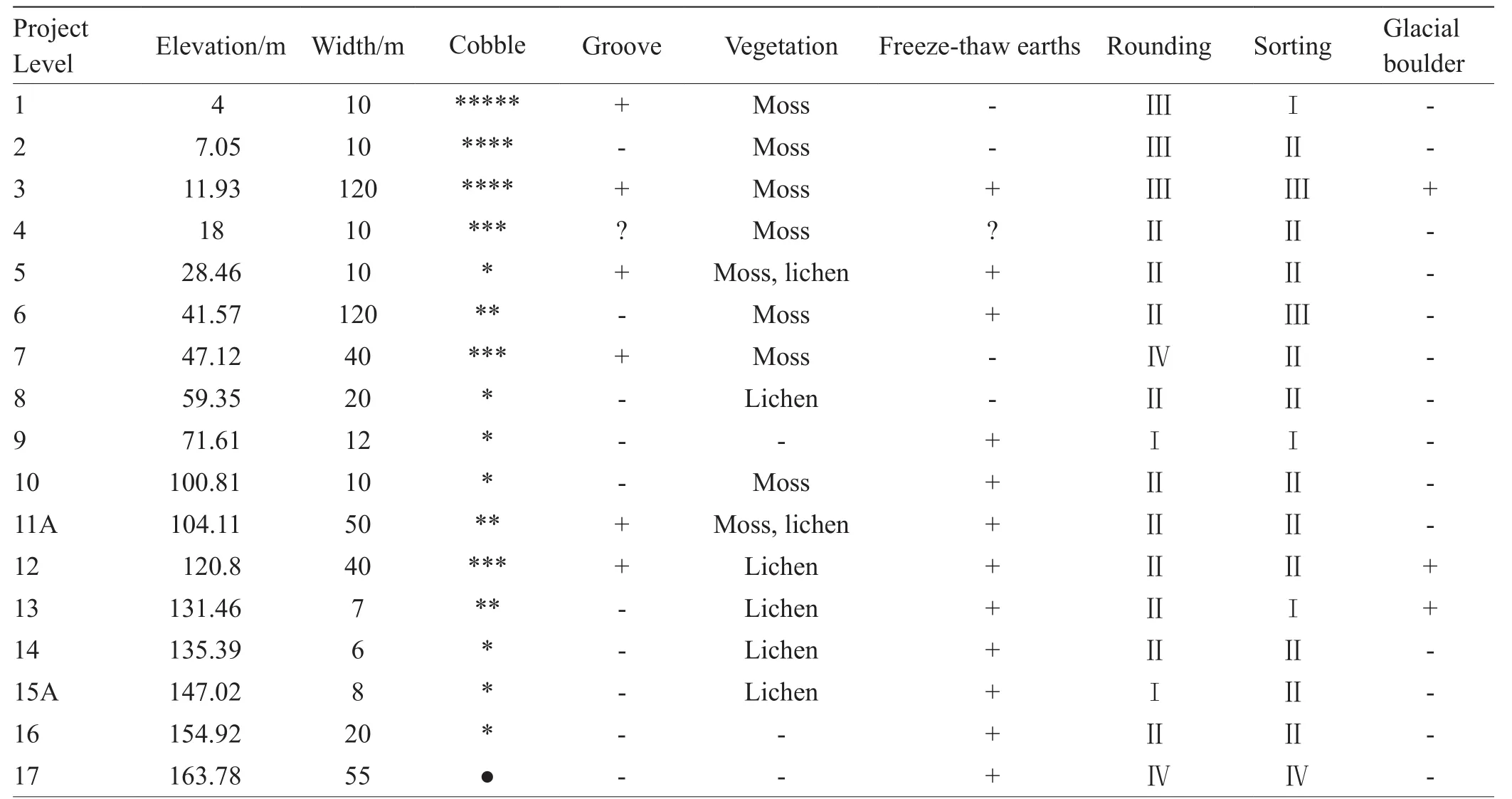
Table 1 Platform and physical characteristics of sediments of coastal terraces of 17 levels in Fildes Peninsula
Matching 17 coastal terraces should also occur on the King George Island since 18.0 ka BP because of the similar regional sea level and climate change, and glacial coverage.A previous study reported wide coastal terraces at 5 m ASL,50 m ASL, and 200 m ASL on Seymour Island, on the Antarctic Peninsula[26]. Three coastal terraces, located at high(21-24 m, 32-35 m), mid (10-17 m), and low (3-5 m) levels were found at Santa Marta, Groft Bay, James Ross Island[27].Holocene terraces were also found on Trinity Peninsula, in West Antarctica[28]. Terraces of different elevations have also been recorded on the Larsen Bay coast, on Seymour Island,Antarctic Peninsula. The terrace at 3 m was formed between 2 ka BP and 2.1 ka BP, and the terrace at 0.5-1 m was formed at 1.2 ka BP[29]. However, the actual chronology of the terrace at 0.5-1 m is 0 because the water level difference of the tides is 2.5 m.
4 Results and discussion
4.1 Probability cumulative grain size curves
As shown by the probability cumulative grain size curves for the sediments on the 17 coastal terraces, the curve of the 2nd terrace is characteristic of double-section control (Figure 4).The rolling particles account for 95%, and belong to a typical gravelly beach. The curves for the 5th and 9th terraces are of three-section control (Figure 4). These terraces contain rolling, saltation, and suspension particles, suggesting that previous beach deposition was mixed with aeolian deposits,and the saltation and suspension particles therefore increased.The curves for the 7th, 10th, and 17th terraces were fourpart form (Figure 4). The terraces contain double saltation particles, indicating a shallow sea depositional environment and an intertidal zone that is easily eroded by high energy waves. The curves for the other terraces reflect the original sedimentary environment and late erosion.
系统供水水源为生产水,主要用于滤体表面绿化。共设置12只喷头,每只耗水量0.46 m3/h。平均夏天每天2次,每次5 min;春秋每周1次,每次5 min;冬季不开启。每年累计开启约18 h,水费以1.2元/m3计。年耗水费为119.232元。
The sediments on all terraces contain coarse particles,and the grain-size parameters show obvious differences:Mzranges from 234 μm to 5 169 μm,Cfrom 8 111 to 77 708 μm, the coarse section from -2.51 to 0.60 φ, the fine section from 1.61 to 4.17 φ, skewness from -0.427 5 to 0.488 0, and stridency from 0.58 to 2.23. The sorting of the sediments is poor,suggesting a complex sedimentary environment.
4.2 Discriminant function analysis-identification of the sedimentary environment
Rocks are usually present only during the physical weathering stage in temporary ice-free areas in Antarctica,and brown earth is poorly developed in sub-Antarctica. As a result, the grain size of sediments is coarse and the sorting is poor. Discriminant function analysis, as proposed by Sahu[30],is inconsistent with the actual environment, and the functions need statistical calculations. We used three beach sediment samples from Larsemann Hills, East Antarctica, and three samples from the 1st, 2nd, and 3rd level coastal terraces on Fildes Peninsula, West Antarctica[19]as examples of standard beach deposition. We also selected three aeolian deposits from Larsemann Hills, and four aeolian lake samples from Tuanjie Lake[8]to represent standard aeolian deposits. The 14 samples were analyzed using Statistic Package for Social Science. The discriminant function is calculated as follows:Yaeolian:beach = 1.704Mz-0.877+ 4.432SKI- 2.318Kg+5.160, whereMzis the median particle diameter of deposits, isσ1is= standard deviation,SKIis skewness andKgis kurtosis.
This function is better suited to identifying aspects of the sedimentary environment, and the origin of sediments in Antarctica. We also applied it to 16 coastal terraces (Tables 2 and 3), and its application to the 4th terrace has been verified by Xie[12].
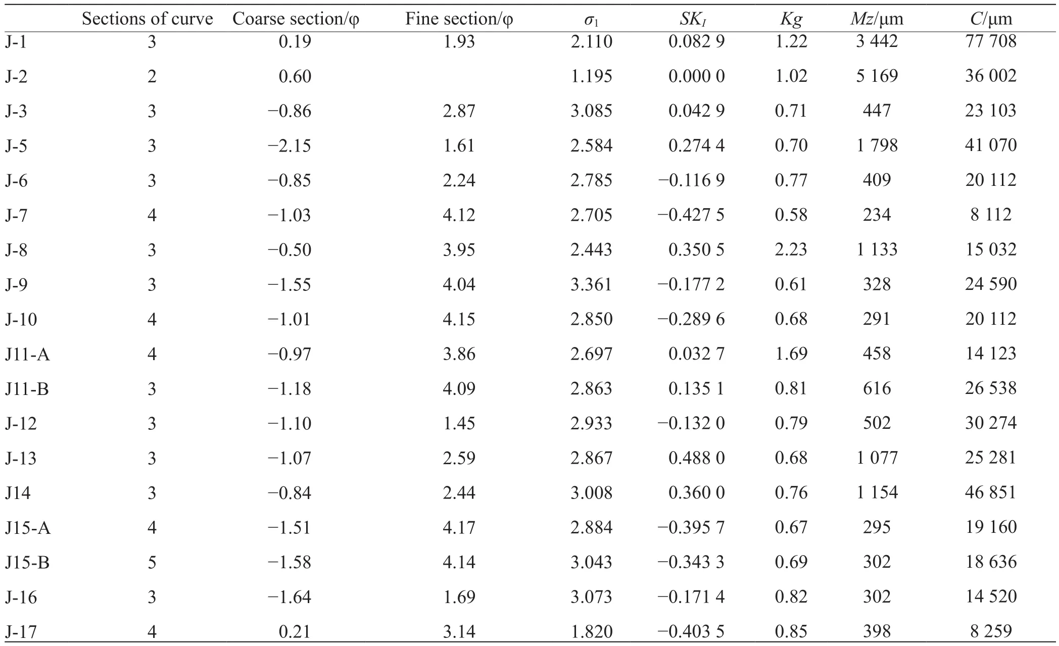
Table 2 Grain size parameters of sediments in coastal terraces of 17 levels
Table 3 Discriminant functions analysis of coastal terraces
Based on the discriminant function analysis, Tuanjie Lake is an aeolian lake. The sediments from the 15 terraces are beach depositions, which show that the platform has 17 coastal terraces, and only J-17 is an aeolian deposit. J-17 is located on the top of Horatio Stump and its sediments may be aeolian. Horatio Stump is the highest peak on Fildes Peninsula, and the provenance of the beach deposition is not apparent. The sediment on J-17 is not beach sediment, and may instead be a mixture of weathering products, aeolian or neritic deposits.
4.3 C-M diagram
TheC-Mdiagram is formed by sample points from a deposit defined byC(the one-percentile) andM(the median of the grain-size distribution), and is plotted at logarithmic scales.Specific wind conditions, freeze-thaw action, and geological events may make theC-Mdiagram difficult to interpret for Antarctica[30]. Currently, there are no typicalC-Mdiagrams of sedimentary samples in Antarctica.
In this study, we used 200 published data points from different sedimentary patterns from Antarctica to draw theC-Mdiagram. The diagram shows a clear ‘S’ region, similar to a typicalC-Mdiagram. However, theCandMvalues have an extended range: the maximumCvalue is 100 000 μm and the maximumMvalue is 10 000 μm, and the minimumCvalue is 100 μm and the minimumMvalue is 7 μm (Figure 5).The graph partition is similar with the typicalC-Mdiagrams,and it can be subdivided by points N, O, P, Q, R, S into five segments NO, OP, PQ, QR, RS each of which corresponds to a particular sedimentation mechanism[31](Figure 5):
(1) Segment NO: The shingle deposits most likely formed from rolled grains and have better sorting, similar to beach sediments.
(2) Segment OP: The sediments are a mixture with a variable proportion of rolled grains and suspension sediments.TheCvalues display insignificant changes and are greater than 20 000 μm in diameter. TheMvalues diminish gradually.
(4) Segment QR: Graded suspension where the sediments carried by exogenetic forces are fine. The particle sizes and density stratification of the sediments are not uniform. TheCvalues are proportional to those ofM, and the sorting of fine and coarse sediments is similar.
(5) segment RS: Uniform suspension where the grain size of the sediments is finer. The sediments are a mixture of silt and clay, and the coarsest particles are thick silt.TheMvalues decrease gradually, and theCvalues remain unchanged. The segment in the diagram is approximately parallel to theM-axis, the maximumCvalue is approximately 700 μm, and theMvalue is usually less than 100 μm.
TheC-Mpattern is subdivided by points N, O, P, Q,R, and S into five segments, each of which correspond to a particular sedimentation mechanism, which is expected from aC-Mdiagram in Antarctica.
Cu: TheCvalue near point R in segment RS represents the size of the coarsest particle in uniform suspension andCuis 220 μm.
Cs: TheCvalue near point Q in segment QR represents the size of the coarsest particle in graded suspension andCsis 1 000 μm.Csusually ranges from 500 to 1 000 μm.
Cr: TheCvalue near point P in segment PQ represents the particle size of easily rolling transport andCris 7 900 μm.
The above three values define the critical particle size of the different types of transport on King George Island. A gap exists between theCs- andCr-values in natural sediments and the particles between them move through saltation transport.
TheCandMvalues of ancient cave sediment samples on the 5th level coastal terraces plot in the rolling transport segment. The values of terrace deposits also occur mostly in the rolling transport segment. Only the values for J-7 and J-17 are in the rolling and suspension transport segment, which confirms that the sample site on the 17th terrace is reworked by wind. The values of the Y2 lake sediments on the 3rd level terraces plot mostly in the graded suspension segment,overlapping with a sea salt lake, and the partial values are in the uniform suspension segment and overlap with a shallow sea, such as the Great Wall Bay. In summary, these results further verify the platform as 17 coastal terraces.
5 Conclusions
(1) The Fildes Peninsula on King George Island has 17 coastal terraces.
(2) The grain size of deposition on the 17 terraces follows a Gaussian distribution;Mzranges from 234 μm to 5 169 μm;Cfrom 8 111 to 77 708 μm; the coarse section from -2.51 to 0.60 φ; the fine section from 1.61 to 4.17 φ;skewness from -0.427 5 to 0.488 0; and stridency from 0.58 to 2.23. The sorting of sediments is poor, indicating a complex sedimentary environment.
(3) Samples collected from the 7th and 17th coastal terraces contain aeolian deposits. The standardC-Mdiagram for Antarctica defines the critical particle sizes of different transport combinations and distinguishes the origin of sediments.
(4) Horatio Stump has uplifted from an ancient beach or shallow sea to the present-day 17th coastal terrace because of climate warming and ice-retreat since 18.0 ka. Relatively stable periods of climate indicate the stability of the earth’s crust, and the 17 coastal terraces formed under the erosion of waves during these periods. The different widths of the terrace platforms reflect stable climate periods of different length since 18.0 ka.
(5) The consistency of regional sea level eustacy,climate change, and glacial area suggest the occurrence of similar coastal terraces on King George Island since 18.0 ka.
1 David T W E, Priestly R E. Geological observations in Antarctica by the British Antarctic Expedition, 1907-1909//Shackleton E H, The Heart of the Antarctic. London: William Heinneman, 1909, 2: 324-327
2 Speden I G. Post-glacial terraces near cape chocolate, McMurdo Sound, Antarctica. NZ J Geol Geophys, 1960, 3(2): 203-217
3 Nichols R L. Coastal geomorphology, McMurdo Sound, Antarctica.IGY World Data Center A, Glaciology, American Geographical Society, 1968, 5(39): 357-359
4 Claridge G C, Campbell I B. The raised beaches at Inexpressible Island, Antarctica. N Z J Geol Geophys, 1966, 9: 889-900
5 Denton G H, Prentice M L, Kellogg D E, et al. Late Tertiary history of Antarctic Ice Sheet: Evidence from the dry valleys. Geology, 1984,12: 263-267
6 Denton G H, Bockheim J G, Wilson S C, et al. Late Wisconsin and early Holocene glacial history, inner Ross Embayment, Antarctica.Quat Res, 1989, 31(2): 151-182
7 Mâusbacher R. Distribution and Stratigraphy of raised interglacial marine sediments on King George Island, South Shetlands, Antarctica.Z Geomorphy N F, 1992, 86: 113-123
8 Li Y F, Zhang Q S. Recent foraminifers from Great Wall Bay, King George Island, Antarctica. Acta Micropalaeontol Sin, 1986, 3(4): 335-346 (in Chinese)
9 Li B Y, Li Y F, Zhao Y, et al. The Late Pleistocene shallow-water marine sediments in the Fildes Peninsula. Chin Sci Bull, 1996,41(19): 1765-1767 (in Chinese)
10 Yang S R, Chen X B. Late Quaternary diatoms from the Yan’ou lake, King George Island, Antarctica (Ⅰ-Ⅱ): Coscinodiscales. Acta Micropalaeontol Sin, 1994, 11(3): 273-286 (in Chinese)
11 Xie Y Y, Cui Z J. The environment events at King George Island since the last glaciation. Quat Sci, 1990, (3): 272-281 (in Chinese)
12 Xie Y Y. Geomorphic feature and environmental evolution at the Great Wall station region, Antarctica. Chin Sci Bull, 1987, 15: 1174-1179 (in Chinese)
13 Zhu C, Cui Z J. Distribution of periglacial geomorphology and the relationship between the periglacial geomorphology and the glaciational history on Fildes Peninsula, King George Island,Antarctica. Sci Geogr Sin, 1991, 11(4): 336-343 (in Chinese)
14 Zhu C. Modern Periglacial Landforms Study. Nanjing: Jiangsu Science and Technology Press, 1994: 177-213 (in Chinese)
15 Zhen X S, Molan E, Liu X H, et al. The volcanic geology, petrological characteristics and the formation and evolution of the Tertiary volcanic rocks from the Great Wall Station area, King George Island,West Antarctica. Antarctic Res, 1991, 3(2): 10-108 (in Chinese)
16 Orheim O. Volcanic Activity on Deception Island, South Shetland Islands. Oslo: Antarctic Geology and Geophysics, 1972
17 Li Z N, Liu X H. Geological characteristics of the volcanic rocks series in the Great Wall Station area, Fildes Peninsula, King George Island, Antarctica. Geol Rev, 1987, 33(5): 475-478 (in Chinese)
18 Li S K. A study on the sediments of the Larsemann Hills, east Antarctica. Geogr Res, 1994, 13(4): 8-18 (in Chinese)
19 Xie Y Y. Sedimentary landform analysis. Beijing: China Ocean Press.2000: 250-254 (in Chinese)
20 Li S K, Zhang Q S. Landform of ice free region and climate changes since late Pleistocene Epoch in Antarctica//The Chinese Antarctic scientific research achievements and progress. Beijing: China Ocean Press, 1998: 301-342 (in Chinese)
21 Williams M A. Quaternary environment. Beijing: China Science Press, 1997: 50-61
22 Kelsey H M, Bockheim J G. Coastal landscape evolution as a function of eutasy and surface uplift rate, Cascadia margin, Southern Oregon.Geol Soc Amer Bull, 1994, 106(6): 840-854
23 Wight L W. Variation in the level of the cliff/shore platform junction along the south coast of Great Britain. Mar Geol, 1970, 9(5): 347-353
24 Stephenson W J. Shore platforms: A neglected coastal feature. Progr Phys Geogr, 2000, 24(3): 311-327
25 Liu G N, Cui Z J. The coastal phenomena around Fildes Peninsula of King George Island, South Shetland Islands, Antarctica. Antarctic Research, 1990, 2(3): 18-25 (in Chinese)
26 Zinsmeister W J. Marine terraces of Seymour Island, Antarctic Peninsula. Antarct J US, 1980, 15(5): 25-26
27 Fukuda M, Strelin J, Shimokawa K, et al. Permafrost occurrence at ice-free ground in James Ross and Seymour Islands, Antarctic peninsula area. Proc NIPR Symp on Antarct Geos, 1991, 5: 162-163
28 Birkenmajer K. Quaternary geology at Hope Bay, Trinity Peninsula[West Antarctica]. Bull Pol Acad Sci: Earth Sci, 1993, 41(2): 99-114
29 Omoto K. Coastal landform and radiocarbon age of cryogenic mounds observed at Larsen Cove, Seymour Island, East of Antarctic Peninsula. Proceedings of the Institute of Natural Sciences, Nihon University, 1995, 3: 11-22 (in Japanese)
30 Sahu B K. Depositional mechanisms from the size analysis of clastic sediments. J Sediment Petrol, 1964, 34(1): 73-83
31 Passega R, Byramjee R. Grain-size image of clastic deposits.Sedimentolog, 1969, 13: 233-252
32 Xie Y Y, Li J Y. Preliminary study on sedimentary environment of Xihu Lake in the Great Wall Station area, Antarctica. Antarct Res,1990, 2(1): 43-52 (in Chinese)
33 Xie Y Y. Grain-size characteristics of quaternary sediments in Vestfold Hills, Antarctica//Zhang Q S. Late Quaternary geological and geomorphic research in Vestfold Hills, Antarctica. Beijing: China Science Press, 1985: 153-165 (in Chinese)
34 Li S K. Study on landform evolution and environmental change since late Pleistocene in ice-free regions, Antarctica, 1998//Chinese Arctic and Antarctic Administration. The Chinese Antarctic scientific research achievements and progress. Beijing: China Ocean Press,1998: 310-342 (in Chinese)
35 Li B Y. The Late Pleistocene shallow-water marine sediments and its environmental significance in the valley of Xisi River, Fildes Peninsula, 1987//Chinese Arctic and Antarctic Administration. The Chinese Antarctic scientific research achievements and progress.Beijing: China Ocean Press, 1998: 343-348 (in Chinese)
猜你喜欢
绿色科技(2022年7期)2022-11-16
决策(2021年5期)2021-06-10
农业科技与信息(2021年8期)2021-05-17
北方果树(2020年6期)2020-11-14
好孩子画报(2020年4期)2020-05-14
当代陕西(2019年24期)2020-01-18
南方农业·下旬(2019年2期)2019-06-24
小天使·六年级语数英综合(2016年7期)2016-05-14
作文·初中版(2015年11期)2015-12-02
 Advances in Polar Science2015年1期
- Advances in Polar Science的其它文章
- Assessment of trace metals in droppings of Adélie penguins(Pygoscelis adeliae) from different locations of the Antarctic Peninsula area
- Geographic ranges of ascidians from Antarctica and the southeastern Pacific
- Experimental culture of non-indigenous Juncus bufonius from King George Island, South Shetland Island,Antarctica
- Detection of integron integrase genes on King George Island, Antarctica
- Distribution patterns of typical enzyme activities in tundra soils on the Fildes Peninsula of maritime Antarctica
- Analysis of phosphorus forms in sediment cores from ephemeral ponds on Ardley Island, West Antarctica