土地利用总体规划实施评估
2015-10-21 20:06:01陈绛王巍周作江
安徽农业科学
2015年3期
陈绛 王巍 周作江
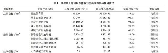
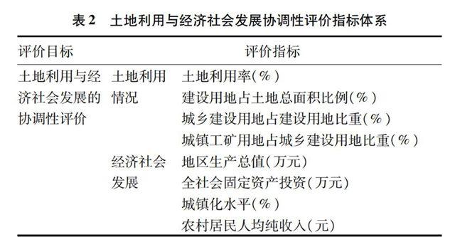
摘要 通过实证研究,评估溆浦县土地利用总体规划(2006-2020年)主要指标的执行情况,并分析了规划实施与区域经济发展的协调程度。结果显示,截至2012年,溆浦县完成了耕地保有量、基本农田保护等目标,但现行规划建设用地指标所剩无多;2006~2009年研究区土地利用与社会经济发展逐渐协调,但2009年之后二者协调性开始下降。溆浦县土地利用总体规划实施形势颇为严峻。研究结果可为及时修改、调整规划提供依据,也为下一步更加合理地实施土地利用总体规划提供参考。
关键词 土地利用总体规划;实施评估;指标;溆浦县
中图分类号 S28 文献标识码 A 文章编号 0517-6611(2015)03-297-02
Study of Land Use Planning Implementation Evaluation: Taking Xupu County as an Example
CHEN Jiang, WANG Wei, ZHOU Zuojiang
(School of Resource and Environmental Science, Hunan Normal University, Changsha, Hunan 410081)
Abstract Through empirical research, implementation of major regulatory indicators of land use planning(2006-2020) in Xupu County was evaluated, the coordination degree of the planning and regional economic development was analyzed. The results showed that by the end of 2012, the amount of cultivated land and the protection of basic farmland was realized in Xupu County; during 2006-2009, land use in study area and social economic development gradually coordinated, but the coordination degree decreased in 2009. The implementation of land use planning in Xupu County is severe. The results can provide basis for timely revision and adjustment, whatmore, provide references for implementing the planning reasonably.
Key words Land use planning; Implementation evaluation; Indicator; Xupu County
作者简介 陈绛(1988- ),女,湖南长沙人,硕士研究生,研究方向:土地利用规划与管理。
收稿日期 20141119
土地利用总体规划由各级人民政府组织编制,其核心是确定或调整土地利用结构和用地布局,其作用是宏观调控和均衡各部门、各行業用地[1]。对规划的实施进行评价,可以全面、有效地发现、检测和监督其对区域社会经济发展产生的作用,并形成信息的反馈,继而为规划的修正、调整提出针对性的建议,使土地利用总体规划进入一个可持续的循环中[2]。
1 研究区概况
溆浦县位于110°15′40″~111°01′07″ E、27°17′31″~28°19′27″ N,属亚热带湿润气候。地处湖南省西部,怀化市东部,沅水中游,雪峰山西麓,地势自东南向西北倾斜,是典型的低山丘陵区。县辖14个建制镇,29 个乡,土地总面积
342 911.02 hm2。至2012年末,县域总人口为92.59万,城
镇化水平为22.15%。地区生产总值为103.14亿元,人均地区生产总值为12 839元,全社会固定资产投资完成61亿元[3]。……
登录APP查看全文