无人机航拍林业虫害图像分割复合梯度分水岭算法
2017-11-24 06:06张军国冯文钊胡春鹤骆有庆
农业工程学报 2017年14期
张军国,冯文钊,胡春鹤,骆有庆
(1. 北京林业大学工学院,北京 100083;2. 北京林业大学林学院,北京 100083)
·农业航空工程·
无人机航拍林业虫害图像分割复合梯度分水岭算法
张军国1,冯文钊1,胡春鹤1,骆有庆2※
(1. 北京林业大学工学院,北京 100083;2. 北京林业大学林学院,北京 100083)
针对林业信息监测方式实时性差、监测范围有限等问题,为更加实时、准确地对林业虫害信息进行监测并计算监测样地中虫害区域比例,该文在搭建面向林区虫害监测的多旋翼无人飞行器航拍监测系统基础上,提出了一种基于复合梯度分水岭算法的图像分割方法。该方法引入全局直方图均衡化消除了图像暗纹理的影响,并采用形态学混合开闭重构滤波完成了图像样本的去噪处理。计算灰度图像各像素点的复合梯度实现了非相关区域(道路及裸地)的提取,最终利用分水岭算法实现了监测图像虫害区域的分割提取。利用该文所提算法对8幅虫害侵蚀程度不同的监测图像进行分割,并与传统分水岭算法、K-means聚类算法进行对比试验。试验结果表明,该文算法虫害区域提取的平均相对误差率分别降低 6.56%、3.17%,平均相对极限测量精度分别改善 7.19%、2.41%,能够相对准确地将虫害区域从监测图像中分割出来,可为后续林业虫害监测与防护提供参考。
无人机;算法;监测;图像分割;复合梯度
0 引 言
森林作为陆地生态系统的主体,是人类赖以生存及社会发展不可或缺的资源[1]。而林业虫害对森林资源的危害非常严重,根据调查结果表明,平均每年发生林业虫害面积有1 333万hm2左右,约占中国林地总面积的6%[2]。因此林业虫害防治形势十分严峻,而科学有效地对林业虫害信息进行监测则是解决这一问题的重要前提。目前,常用的林业虫害监测方法主要为人工直接测量法[3]、引诱剂诱集法[4]、卫星遥感测量法[5]以及无线传感器网络监测法[6-7]。然而,现有监测方法仍存在一定的缺陷,人工直接测量法监测效率低、实时性差且存在安全隐患;引诱剂的诱集效果会受诱捕器悬挂高度和生态环境类型的影响;卫星遥感测量法不能精确测量局部微观信息;无线传感器网络监测法只能进行地面监测,监测范围有限。为了避免上述问题,利用小型化无人机作为监测载体的方法逐渐取得了学者们的广泛关注[8-9]。其中,多旋翼无人飞行器作为一种低空遥感平台,具有结构简单、制造维护成本低、便于携带和易于操作等特点[10],可以实时、高效地低空采集林区植被图像信息。
如何从图像中有效地提取出健康林区与虫害区域则是研究的关键[11]。目前图像分割方法在林业虫害监测领域的应用越来越广[12],已有国内外学者提出了应用于林业虫害监测领域的图像分割方法。例如边缘检测[13-15]、聚类法[16-18]、基于分数演算的分水岭算法[19]和基于显著和模糊检测的图像分割方法[20]等。但是,由于虫害监测图像中非相关区域与病虫害区域颜色相近,而目前现有的算法并没有针对虫害区域分割提取过程中图像非相关区域的影响问题进行深入研究,同时大部分算法只针对地面图像进行分析,不适用于多旋翼无人飞行器航拍图像[21]。
基于以上情况,本文以辽宁省建平县遭受油松毛虫侵蚀的油松林为研究对象,搭建了面向林业虫害监测的多旋翼无人飞行器图像采集平台,提出了一种基于复合梯度分水岭算法的图像分割方法,实现了林业虫害监测图像进行有效提取,解决了非相关区域对虫害区域分割提取的影响问题以及图像分割中存在的过分割现象。
1 林区虫害监测飞行器平台设计
本文采用自主设计的八旋翼飞行器执行林区虫害监测图像的监测任务。八旋翼飞行器采用 8个独立电机驱动,相邻电机旋转方向相反,相对电机旋转方向相同。由于电机旋转导致的扭矩相互抵消,保证了飞行器扭矩平衡不会产生自旋[22]。飞行器通过控制 8个旋翼的转速变化实现对飞行器6个自由度的控制。
1.1 坐标系定义
采用大地平面假设,建立相对于地球静止的惯性坐标系和相对于飞行器本体的机体坐标系[23],具体如图 1所示。其中机体坐标系X轴为飞行器前进与后退方向,轴向与电机M4和M8所在轴重合;Y与Z轴垂直;Z轴为垂直机体本身方向。采用欧拉角(俯仰角、横滚角、偏航角)对飞行器姿态进行描述[24]。

图1 八旋翼飞行器系统坐标系Fig.1 Eight rotor aircraft coordinate system
1.2 机载航电系统设计
本文设计的八旋翼飞行器机载航电系统包括如下 6个部分,即飞行控制器、惯性导航系统、数据传输系统、无刷电机调速器、供电系统以及信息采集系统,结构框图及其实物图如图2、图3所示。其中飞控计算机微处理器采用意法半导体公司 STM32F103RCT6芯片,具有精度高、速度快、硬件性能强以及接口资源丰富等优点。惯性导航系统采用 9轴数字运动处理器(digital motion processor,DMP)[25]MPU6050,相较于多组件方案,DMP免除了组合陀螺仪和加速器时之轴间差的问题。光学图像采集设备使用松下GH3单反相机,其搭载在八旋翼飞行器的三轴云台上,可以采集高清、稳定的林区低空航拍图像。
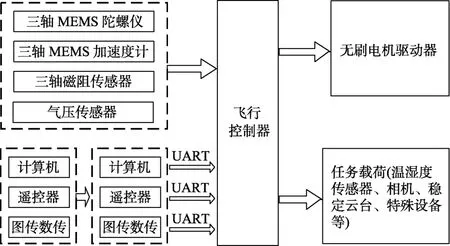
图2 机载航电系统结构框图Fig.2 Structure block diagram of airborne avionics system

图3 八旋翼飞行器监测平台实物图Fig.3 Practicality image of eight rotor aircraft monitoring platform
1.3 姿态控制系统设计
飞行器采用串级PID(proportion integration differentiation)控制算法设计飞行器控制系统,实现姿态跟踪控制。控制器外环为角度环,内环为角速度环。外环输入量为飞行器欧拉角,给定角度由遥控器或串口控制终端设定,通过 PID控制器得到输出量角速度,作为指令输入到内环。内环根据输入,利用PID控制器输出电机控制信号,通过PWM信号发生器控制桨叶电机转速,进而控制飞行器飞行姿态。系统控制结构如图4所示。

图4 串级PID控制框图Fig.4 Diagram of cascade PID control
1.4 监测图像采集
本文利用八旋翼飞行器针对辽宁省试验林区进行实地图像采集,该试验林区主要受到松毛虫和木蠹蛾的侵蚀,侵蚀后树木表现为枯死现象,采集图像及受灾现象如图 5所示。通过对采集图像质量的综合考虑,选取阴天多云天气采集图像。飞行器在监测区域中心起飞,垂直上升过程中飞行器每隔5 m悬停5 s采集图像。图像依靠机载单反相机(分辨率为4 608×2 592像素)以正摄图像[25]采集方式得到,共采集30~100 m图像451张(其中油松林167张、沙棘地148张、红松72张、白桦64张),数据存储大小为 2.58 G。综合考虑图像分割对采集图像的像素要求,选取拍摄高度约为50 m的8张监测图像。

图5 辽宁省建平县监测图像效果图Fig.5 Monitoring images effect in Jianping country,Liaoning province
2 基于复合梯度分水岭算法的图像分割方法
传统的分水岭图像分割算法对噪声比较敏感[26],在图像受到复杂噪声干扰及暗纹理影响时,分割结果无法满足需求,甚至会产生严重的过分割现象。此外,虫害区域的分割图像中往往还存在大量的非相关区域,而传统分水岭算法对此缺乏处理能力。针对以上问题,本文提出一种基于复合梯度的分水岭图像分割算法对虫害监测图像进行处理。
算法关键步骤如下:1)对输入图像进行全局直方图均衡化图像增强处理并对其进行形态学混合开闭重构滤波;2)计算预处理后的灰度图像的复合梯度提取梯度图像;3)利用分水岭变换对梯度图像进行分割,对非林区区域进行提取;4)在原始图像的基础上去除非林区区域,进行灰度变换,计算灰度图像的复合梯度提取梯度图像;5)利用分水岭变换对梯度图像进行分割提取虫害区域并进行区域合并。
2.1 图像预处理
为了有效降低噪声与暗纹理对分割图像的影响,针对图像噪声,本文采用形态学混合开闭重构滤波[27-28],对图像样本进行处理。形态学混合开闭重构滤波在降低噪声干扰的同时还可以保持图像中剩余连续区域的边缘,在后续分割时不会产生新的轮廓边缘[29]。
针对图像暗纹理,本文采用全局直方图均衡化对图像进行增强处理。具体处理过程如下:假设将图像gzh(x,y)的灰度级r归一化到区间[0,1],r=0时为黑色,r=1时为白色。gzh(x,y)灰度级范围为[0,L-1],像素的总数为n,则有灰度级为rk的像素个数为nk。其全局直方图均衡化对应的变换如式(1)所示。

式中Pr(rj)为gzh(x,y)的概率分布函数,Sk即为图像gzh(x,y)的灰度级k从0取至(L-1)时,对图像gzh(x,y)概率分布函数Pr(rj)求和,L为图像灰度级总数。
对经过图像增强的彩色图像进一步进行灰度变换得到灰度图像并对其进行开运算并对其结果进行闭运算(灰度图像6a为参考图像,结构元素选为正方形,尺寸为3×3像素),即可利用开闭重构得出滤波后的图像。输入图像的灰度图像、开操作图像、闭操作图像如图6a、6b、6c所示。

图6 滤波过程效果图Fig.6 Result of filtering process
2.2 非相关区域提取
图像中非相关区域(道路及裸地)的分割结果会对虫害区域分割结果的提取产生干扰,使得分割结果不准确。为解决上述问题,本文先提取出非相关区域,再对虫害区域进行分割处理。
首先对预处理后的灰度图像进行复合梯度的求解。通过计算灰度图像各像素点的复合梯度[30]得到梯度图像,各像素点的复合梯度Cg的计算如式(2)所示。
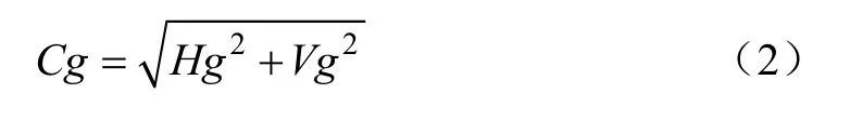
式中水平复合梯度Hg和垂直复合梯度Vg分别通过微分模板计算即可得到,如矩阵(3)所示。
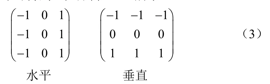
水平/垂直微分模板代表相对于像素点水平/垂直方向 0º与 180º、45º与 135º、-45º与-135º的邻域像素点灰度值差值相加后取平均值。
统计各梯度层频率,根据当前像素点的梯度信息将其放入排序数组中的合适位置,梯度值越低的像素点存放的位置越靠前,相同梯度值的点为一个梯度层。然后寻找图像的极小区域 (此区域通过阈值判定) 并对其进行标记,区域的面积为区域中像素点的个数,本文选取的阈值为整幅图像面积的1%。若同一梯度层相邻像素点均已标记且标记相同,将 2个区域合并。去除所有小于特定像素数H(此处H设为20)的斑点污渍。最后进行分水岭变换,提取出非相关区域图像。
2.3 虫害区域分割提取
由于非相关区域对虫害区域提取的影响,本文采用在输入图像的基础上去除非相关区域,所的图像作为虫害区域分割提取的输入图像。通过对三原色 RGB(red,green, blue)、色彩模型Lab(L代表亮度Luminosity, 通道a正值为红色,负值为绿色;通道b正值为黄色,负值为蓝色)、颜色模型HSL(hue, saturation, lightness)和灰度图像颜色空间效果的比较,采用更能直接反映图像特征的L变量(亮度信息),也就是灰度图像作为颜色转换空间。通过计算灰度图像的各像素点的复合梯度,进而提取梯度图像。采用分水岭变换对梯度图像进行分割,实现虫害区域的分割提取。
2.4 区域合并
基于复合梯度的分水岭变换所得的虫害提取图像可能仍存在过分割现象,本文采用对分割后的图像进行区域合并。
首先定义区域Ci和Cj的综合距离度量ijD如公式(4)所示。

式中ui为区域Ci的颜色均值向量,uj为区域Cj的颜色均值向量,σi为区域Ci内 3个通道颜色均方差的均值,σj为区域Cj内 3个通道颜色均方差的均值,Eij为区域Ci和Cj公共边缘归一化均值,E为所有边缘归一化均值。其中若Ci和Cj存在邻接关系,且Ci和Cj的综合距离度量Dij小于阈值参数T,则合并Ci和Cj;若所有存在邻接关系的区域综合距离度量均大于T,则合并结束。
2.5 虫害监测图像分割效果
以油松林为例,利用本文方法对监测图像进行虫害区域分割提取的效果图如图7所示,其中对输入图像7a进行图像预处理,得到滤波图像7b和增强图像7c;基于复合梯度实现非相关区域图像7d的提取,如图中白色区域所示;在图像7a的基础上去除非相关区域图像7d并将其转化为灰度图像 7e,初步显现出虫害区域范围;计算灰度图像7e的复合梯度得到梯度图像7f,使得虫害区域更加明显;利用分水岭变换对图像7f进行分割得到虫害区域,如图7g所示;最后将非相关区域图像7d与虫害区域提取图像7g进行区域合并得到最终分割效果,如图7h所示。

图7 虫害监测图像分割效果图Fig.7 Segmentation effect of pest monitoring image
3 试验结果与分析
3.1 不同算法对虫害监测图像分割效果
本文选取虫害侵蚀程度不同的监测图像作为测试样本,侵蚀程度如图 8中不同图像树木枯死面积所示。将本文提出的复合梯度分水岭算法与传统分水岭算法、K-means聚类分割算法的虫害区域分割的提取效果进行了比较,结果如图 8所示。其中传统分水岭算法在分水岭变换的基础上采用形态学混合开闭重构滤波对分割图像进行去噪;聚类分割算法采用K-means聚类算法,参数K设定为20。本文借助图像拆分器通过手动操作方法标注出虫害位置,计算虫害区域比例作为参照真值。
上述 8组试验结果表明,传统分水岭算法得到的虫害区域明显大于真实情况,错误率较高,同时K-means聚类分割算法能够有效提取出虫害区域,但会掺杂非相关区域造成误报。而本文算法得到的结果与人工筛选结果近似,能够有效地提取出虫害区域与非林区区域,从而计算出健康区域、虫害区域、非相关区域在整幅图像中的占比。
3.2 算法性能评价与分析
为了验证本文算法的有效性,采用相对误差率和相对极限测量精度等作为评价指标[31]。相对误差率ξ用于描述分割目标和背景之间的误分辨率。

式中Ni为分割处理后区域i的实际像素点数;Ni*为区域i实际目标像素点数;N为一幅图像实际像素点数;c为区域分割所得的总区域数。相对误差率的高低可以表征分割结果的好坏。

图8 虫害监测图像分割效果对比图Fig.8 Segmentation effect comparison of pest monitoring image
相对极限测量精度σ用于表示目标区域相对参照真值的偏离程度,表征图像分割性能。

式中w为原图像中待分割区域实际像素点数,即为参照真值;wm为采用分割算法分割后所得目标区域像素点数。σ的值越小,分割性能越好。
针对前面所述的 8幅虫害监测图像样本,参照真值采用借助图像拆分器人工标注所计算出的虫害比例。本文算法与传统分水岭算法、K-means聚类算法分割结果的相对误差率及相对测量精度结果如表1所示。

表1 相对误差率与相对极限测量精度测试结果Table 1 Results of relative error rate and relative ultimate measurement accuracy%
通过对以上试验数据的分析,采用传统分水岭算法的平均相对误差率为 8.19%,平均相对极限测量精度为8.50%;K-means聚类算法的平均相对误差率为4.80%,平均相对测量精度为3.72%。而采用本文算法的平均相对误差率为1.63%,平均相对测量精度为1.31%。试验结果表明,本文算法对监测图像虫害区域分割提取结果优于传统分水岭算法、K-means聚类分割算法,其中相对误差率平均降低 6.56%和 3.17%,相对极限测量精度平均改善7.19%和2.41%。
4 结 论
本文在搭建面向林区虫害监测的多旋翼无人飞行器航拍监测系统的基础上,实现了对林区虫害信息实时、高效采集。针对林业航拍监测图像,提出了一种基于复合梯度分水岭算法的多旋翼无人飞行器林业虫害监测图像的分割方法。利用本文所提算法对辽宁省试验林区实地采集到的虫害监测图像进行处理,并从分割效果、相对误差率及相对极限测量精度 3个方面与传统分水岭算法、K-means聚类算法进行比较。试验结果表明,本文算法对监测图像虫害区域分割提取结果优于传统分水岭算法、K-means聚类分割算法,其中相对误差率平均降低6.56%和3.17%,相对极限测量精度平均改善7.19%和2.41%。
[1] 赵铁良,董振辉,于治军,等. 中国森林病虫指数的研究[J]. 林业科学,2003,39(3):172-176.Zhao Tieliang, Dong Zhenhui, Yu Zhijun.Study on establishment of forest pest indexes[J]. Scientia Silvae Sinicae, 2003,39(3):172-176. (in Chinese with English abstract)
[2] 凌天淅,侯辉,周桃龙. 淅川森林病虫害防治[J]. 中国林业,2010,19:49-49.Ling Tianxi, Hou Hui, Zhou Taolong. Prevention and control of forest diseases and pests in Xi Chuan[J]. Forestry of China,2010, 19: 49-49. (in Chinese with English abstract)
[3] 新疆维吾尔自治区林业有害生物防治检疫局. 林业有害生物防治[M]. 北京:中国林业出版社,2010:23-76.
[4] 袁菲,骆有庆,石娟,等. 不同含量引诱剂对落叶松八齿小蠹及其天敌红胸郭公虫的引诱[J]. 林业科学,2012,48(6):89-94.Yuan Fei, Luo Youqing, Shi Juan, et al. Different attractive effects and eag responses of ips subelongatus(coleoptera,scolytidae) and its predator thanasimus substriatus (coleoptera:cleridae) to ipslures[J]. Scientia Silvae Sinicae, 2012, 48(6):89-94. (in English with Chinese abstract)
[5] Leila G, Pir B M, Jamil A, et al. Monitoring infestations of oak forests by tortrix viridana (Lepidoptera: Tortricidae)using remote sensing[J]. Plant Protection Science, 2016,52(4): 270-276. (in Chinese with English abstract)
[6] 齐建东,蒋禧,赵燕东. 基于无线多媒体传感器网络的森林病虫害监测系统[J]. 北京林业大学学报,2010,32(4):186-190.Qi Jiandong, Jiang Xi, Zhao Yandong. A forest pest and disease monitoring system based on wireless multimedia sensor network[J]. Journal of Beijing Forestry University,2010, 32(4): 186-190. (in Chinese with English abstract)
[7] 王艳. 基于物联网的森林病虫害防治智能传感系统研究[D]. 南京:南京林业大学,2012.Wang Yan. Research of Intelligent Sensor System for Forest Pest Control based on the Internet of Things[D]. Nanjing:Nanjing Forestry University, 2012. (in Chinese with English abstract)
[8] 费运巧,刘文萍,骆有庆,等. 森林病虫害监测中的无人机图像分割算法比较[J]. 计算机工程与应用,2017,53(8):216-223.Fei Yunqiao, Liu Wenping, Luo Youqing, et al. Comparison of algorithms for unmanned aerial vehicle image segmentation in monitoring forest diseases and insect pests[J]. Computer Engineering and Applications, 2017, 53(8): 216-223. (in Chinese with English abstract)
[9] Sankarasrinivasan S, Balasubramanian E, Karthik K, et al.Health monitoring of civil structures with integrated UAV and image processing system[J]. Procedia Computer Science,2015, 54: 508-515.
[10] Luck B. Unmanned aerial vehicles (UAVs) in pest management:Progress in the development of a UAV-deployed mating disruption system for Wisconsin cranberries[J]. Nucleosides Nucleotides & Nucleic Acids, 2008, 27(5): 449-459.
[11] 刁智华,王欢,宋寅卯,等. 复杂背景下棉花病叶害螨图像分割方法[J]. 农业工程学报,2013,29(5):147-152.Diao Zhihua, Wang Huan, Song Yinmao, et al. Segmentation method for cotton mite disease image under complex background[J]. Transactions of the Chinese Society of Agricultural Engineering (Transactions of the CSAE), 2013,29(5): 147-152. (in Chinese with English abstract)
[12] Liu C, Liu W, Xing W. An improved edge-based level set method combining local regional fitting information for noisy image segmentation[J]. Signal Processing, 2017, 130: 12-21.
[13] 张静,王双喜. 温室植物病害图像处理技术中图像分割方法的研究[J]. 内蒙古农业大学学报,2007,28(3):19-22.Zhang Jing, Wang Shuangxi. A study on the segmentation method in image processing for plant disease of green house[J]. Journal of Inner Mongolia Agricultural University,2007, 28(3): 19-22. (in Chinese with English abstract)
[14] 姜滨,曹军,崔莉. 基于小波多尺度的林业害虫图像边缘检测[J]. 森林工程,2013,29(4):14-17.Jiang Bin, Cao Jun, Cui Li. Image edge detection for forest pests based on wavelet milti-scale transform[J]. Forest Engineering, 2013, 29(4): 14-17. (in Chinese with English abstract)
[15] 宋蛰存,周秀明. 微分算子在虫害杨树叶片边缘检测的应用[J]. 林业机械与木工设备,2007,35(2):47-49.Song Zhecun, Zhou Xiuming. Application of different operators in edge detection of pest poplar blades[J]. Forestry Machinery and Woodworking Equipment, 2007, 35(2): 47-49. (in Chinese with English abstract)
[16] 李冠林,马占鸿,黄冲,等. 基于K-means硬聚类算法的葡萄病害彩色图像分割方法[J]. 农业工程学报,2010,26(14):32-37.Li Guanlin, Ma Zhanhong, Huang Chong, et al. Segmentation of color images of grape diseases usingK-means clustering algorithm[J]. Transactions of the Chinese Society of Agricultural Engineering (Transactions of the CSAE), 2010, 26(14): 32-37. (in Chinese with English abstract)
[17] Faithpraise F, Birch P, Young R, et al. Automatic plant pest detection and recognition using k-means clustering algorithm and correspondence filters[J]. International Journal of Advanced Biotechnology & Research, 2013, 4(2): 189-199.
[18] Bouyer A, Jalali M, Bouyer A, et al. Developing a rule-based data clustering algorithm for diagnosing of wheat pest[J].Global Journal on Technology, 2013, 3: 1549-1555.
[19] Liu W. A marker-based watershed algorithm using fractional calculus for unmanned aerial vehicle image segmentation[J].Journal of Information & Computational Science, 2015,12(14): 5327-5338.
[20] 陈雷,袁媛,吴娜,等. 基于显著和模糊检测的浅景深作物病害图像分割[J]. 农业工程学报,2015,31(增刊 2):145-151.Chen Lei, Yuan Yuan, Wu Na, et al. Segmentation for low depth of field crop disease images based on saliency and blurred detection[J]. Transactions of the Chinese Society of Agricultural Engineering (Transactions of the CSAE), 2015,31(Supp.2): 145-151. (in Chinese with English abstract)
[21] Merabet Y, Meurie C, Ruichek Y, et al. Building roof segmentation from aerial images using a lineand region-based watershed segmentation technique[J]. Sensors, 2015, 15(2):3172-3203.
[22] Salazar S, Romero H, Lozano R, et al. Modeling and realtime stabilization of an aircraft having eight rotors[J]. Journal of Intelligent & Robotic Systems, 2009, 54(1): 455-470.
[23] 赵世荣,孙运强,石喜玲. 基于信息融合的八旋翼飞行器状态解算[J]. 弹箭与制导学报,2016,36(2):167-170.Zhao Shirong, Sun Yunqiang, Shi Xiling. Attitude estimation of octorotor aircraft based on information fusion[J]. Journal of Projectiles, Rockets, Missiles and Guidance, 2016, 36(2):167-170. (in Chinese with English abstract)
[24] 常彦春. 多旋翼无人飞行器自主飞行控制系统设计研究[D]. 北京:北京理工大学,2016.Chang Yanchun. Research on the Autonomous Flight Control System of Muti-rotor Aricraft[D]. Beijing: Beijing Institute of Technology, 2016. (in Chinese with English abstract)
[25] Michael N, Mellinger D, Lindsey Q, et al. The grasp multiple micro-uav testbed[J]. Robotics & Automation Magazine,IEEE, 2010, 17(3): 56-65.
[26] Franchi G, Angulo J. Bagging stochastic watershed on natural color image segmentation[J]. Lecture Notes in Computer Science, 2015, 9082: 422-433.
[27] 江怡,梅小明,邓敏,等. 一种结合形态滤波和标记分水岭变换的遥感图像分割方法[J]. 地理与地理信息科学,2013,29(2):17-21.Jiang Yi, Mei Xiaoming, Deng Min, et al. Segmentation of remote sensing imagery combined with morphological filtering and marked watershed transformation[J]. Geography and Geo-Information Science, 2013, 29(2): 17-21. (in Chinese with English abstract)
[28] 夏平,刘馨琼,向学军,等. 复合形态滤波和改进型分水岭算法的图像分割[J]. 三峡大学学报自然科学版,2008,30(5):60-63.Xia Ping, Liu Xinqiong, Xiang Xuejun, et al. Image segmentation based on compound morphology filter and modiffied watershed algorithm[J]. Journal of China Three Gorges University: Natural Sciences, 2008, 30(5): 60-63. (in Chinese with English abstract)
[29] 杨信廷,孙文娟,李明,等. 基于K均值聚类和开闭交替滤波的黄瓜叶片水滴荧光图像分割[J]. 农业工程学报,2016,32(17):136-143.Yang Xinting, Sun Wenjuan, Li Ming, et al. Water droplets fluorescence image segmentation of cucumber leaves based onK-means clustering with opening and closing alternately filtering[J]. Transactions of the Chinese Society of Agricultural Engineering (Transactions of the CSAE), 2016, 32(17): 136-143. (in Chinese with English abstract)
[30] 江霞. 基于复合梯度分水岭算法的彩色白血细胞分割[D].长沙:中南林业科技大学,2012.Jiang Xia. Color Leukocyte Image Segmentation based on Composite Gradient Watershed Algorithm[D]. Changsha:Central South University of Forestry and Technology, 2012.(in Chinese with English abstract)
[31] Mesascarrascosa F J, Rumbao I C, Berrocal J A, et al.Positional quality assessment of orthophotos obtained from sensors onboard multi-rotor UAV platforms[J]. Sensors, 2014,14(12): 22394-22407.
Image segmentation method for forestry unmanned aerial vehicle pest monitoring based on composite gradient watershed algorithm
Zhang Junguo1, Feng Wenzhao1, Hu Chunhe1, Luo Youqing2※
(1. School of Technology, Beijing Forestry University, Beijing100083,China;2.School of Forestry, Beijing Forestry University, Beijing100083,China)
The application of multi-rotor unmanned aerial vehicle monitoring system for forest pest information collecting has many advantages, such as low running cost, operating flexibility, easy access to data, high image resolution etc. It has been regarded as a quick access to forest insect pest information collecting. By use of unmanned aerial vehicle system, valid segmentation and extraction of pest images acquired with the help of multi-rotor unmanned aerial vehicle can be used to calculate the insect pest proportion in monitored sample field. It can provide forest conservation experts with evidence for assessing the insect pest damage. To conduct forest monitoring work and calculate the proportion of pest infested area in monitored sample field with more preciseness and fast turnaround, in this paper, we aimed to solve poor time response circle and limited monitoring range problems that exist in current forestry information monitoring method. Firstly, in this paper, we built both hardware and software systems of multi-rotor unmanned aerial vehicle. Aerial vehicle equipped with image collecting devices was used to monitor in forestry pest insect infested area and collect data in the Liaoning testing forest. In order to obtain proper resolution images, aerial vehicle took off the center of the chosen monitoring area vertically to collect photo resources. By considering needed resolution requirements on image segmentation comprehensively, the height of about 50 m was chosen for image acquisition. On the analytical basis of monitoring images, an image segmentation method based on composite gradient watershed algorithm was proposed. This method introduced global histogram equalization to eliminate the influence of dark texture and adopted the morphological hybrid open-closing reconstruction filter to complete the denoising work of the image samples, eliminate the image interference to the segmentation effect, and suppress the over-segmentation phenomenon in image segmentation process. The gray-scale image was obtained by gray-scale transformation of the pre-processed image. The non-correlation regions (road and bare ground) were extracted by calculating the composite gradient of each pixel point in the gray image. Interference to the segmentation result may arise in segmenting process due to the similar color of non-correlation region and pest insect infested area. In this paper, the mentioned region was removed from the original image, which greatly avoided the interference of the non-related region to the pest area and ensured the accuracy of the result. Finally, the watershed algorithm was applied to realize the segmentation and extraction of insect pest area in images. In order to verify the effectiveness of the proposed method, the traditional watershed algorithm and K-means clustering algorithm were used for comparing experiment methods in the segmentation of eight images with different levels of insect pest. With the help of mage segmentation device, the accurate pest insect infested area was labeled manually, and it was taken as reference value in pest insect proportion calculating step. The experiment result showed that the segmentation effect was much more similar to the manual operation result. Specifically, the relative error rate decreased by 6.56% and 3.17% and the relative limit measuring accuracy was improved by 7.19% and 2.41% in this proposed method when traditional watershed algorithm was compared withK-means cluster algorithm. Our result showed that multi-rotor unmanned aerial vehicle was helpful in real time and effective monitoring of forest pest insect. The algorithm proposed in this paper was able to accurately segment and extract pest insect area in monitoring images and the proportion of pest area in whole sample fields was acquired, thus providing valid data support for forest pest monitoring and preventing work in the future.
unmanned aerial vehicles; algorithms; monitoring; image segmentation; composite gradient
10.11975/j.issn.1002-6819.2017.14.013
TP391.4; S126
A
1002-6819(2017)-14-0093-07
张军国,冯文钊,胡春鹤,骆有庆. 无人机航拍林业虫害图像分割复合梯度分水岭算法[J]. 农业工程学报,2017,33(14):93-99.
10.11975/j.issn.1002-6819.2017.14.013 http://www.tcsae.org
Zhang Junguo, Feng Wenzhao, Hu Chunhe, Luo Youqing. Image segmentation method for forestry unmanned aerial vehicle pest monitoring based on composite gradient watershed algorithm[J]. Transactions of the Chinese Society of Agricultural Engineering(Transactions of the CSAE), 2017, 33(14): 93-99. (in Chinese with English abstract)
doi:10.11975/j.issn.1002-6819.2017.14.013 http://www.tcsae.org
2017-03-12
2017-05-15
林业公益性行业科研专项资助(201404401);国家自然科学基金项目资助(31670553);中央高校基本科研业务费专项资金资助(2016ZCQ08)
张军国,教授,博士生导师,主要从事图像处理与人工智能研究。北京 北京林业大学工学院,100083。Email:zhangjunguo@bjfu.edu.cn
※通信作者:骆有庆,教授,博士生导师,主要从事森林有害生物可持续控制研究。北京 北京林业大学林学院,100083。Email:yqluo@bjfu.edu.cn
猜你喜欢
现代电子技术(2021年1期)2021-01-17
河北果树(2020年4期)2020-11-26
长江丛刊(2020年13期)2020-11-19
今日农业(2019年13期)2019-08-12
上海大学学报(自然科学版)(2018年5期)2018-11-02
电脑知识与技术(2018年35期)2018-02-27
现代园艺(2017年22期)2018-01-19
现代园艺(2017年19期)2018-01-19
百姓生活(2017年5期)2017-05-15
自动化学报(2017年11期)2017-04-04