China’s BeiDou Navigation System Is Benefiting the World
2018-01-05 01:43CompiledbyBoNingTranslatedbyLiuJie
Special Focus 2017年12期
Compiled by Bo Ning Translated by Liu Jie
China’s BeiDou Navigation System Is Benefiting the World
Compiled by Bo Ning Translated by Liu Jie
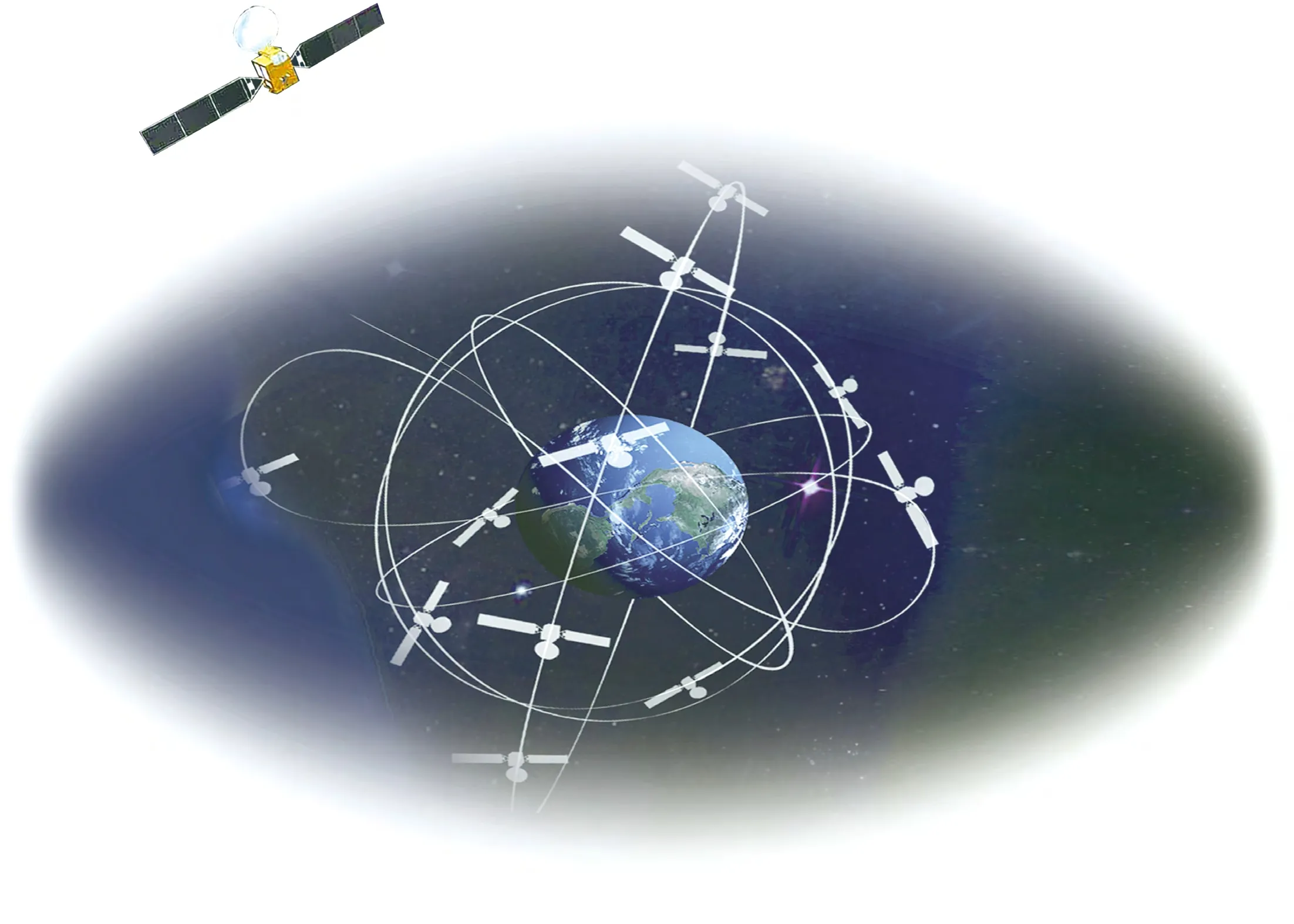
“双星定位”建设方案:把地心视为一颗虚拟卫星、再发射两颗地球同步卫星构成星座,经地面控制中心计算处理,实现对地面目标的快速定位。(制图/万璇)“Duel-satellite positioning” plan:Take the earth’s core as a virtual satellite,which forms a constellation with the other two geosynchronous satellites launched into the orbit, thus realizing rapid positioning of a ground target through the computing process of the ground control center.(Photo edited by Wan Xuan)
On the drilling grounds, the army was embattling; the war flags, soldiers,fighter planes, and war vehicles just finishing their drilling were inspected by the supreme commander with no error at all. On the rough South China Sea,the fishermen roving over the sea,generation after generation, to make their living had to pray to Goddess Matsu for their safety on the sea. But nowadays, they no longer need to rely on Matsu for their safety, for no matter what waters or island they get to,the mother land will be overlooking them from above.
All these are due to China’s BeiDou Navigation Satellite System hovering in the starry sky.
On November 5, China successfully launched two BeiDou-3 satellites via a single carrier rocket to support its global navigation and positioning network from the Xichang Satellite Launch Center in Sichuan Province. The launching of the fi rst two BeiDou-3 satellites symbolizes the beginning of a new era of global networking for the BeiDou system.
沙场,三军列阵。刚下演兵场的战旗、战士、战鹰、战车,接受最高统帅检阅,米秒不差;南海,惊涛骇浪。世代漂泊在这里求妈祖、讨生活的渔民,如今无论到哪块海域、哪个岛礁,都在祖国俯瞰之中。这些,都缘自翱翔星空的中国“北斗”。
11月5日,中国在西昌成功发射两颗北斗三号全球组网卫星。这是北斗三号卫星的首次发射,标志着北斗卫星导航系统步入全球组网新时代。
打造大国重器
中国是继美国、俄罗斯之后世界上第三个拥有自主卫星导航系统的国家。卫星导航系统是重要的空间信息基础设施,从上世纪后期开始探索,中国逐步形成从北斗一号服务国内,到北斗二号提供区域服务,再到北斗三号全球组网的发展战略,服务扩大到全球。建设过程中,困难从不鲜见。
2005年,正在建设的北斗二号系统的“原子钟”突遇问题。原子钟就如同一块“手表”,为卫星导航用户提供精确的时间信息服务。
它直接决定系统导航定位精度,其重要性如同人的心脏。国外的技术封锁,成为制约北斗卫星导航系统工程建设的瓶颈。
Following the U.S. and Russia, China is the third country in the world to launch their self-developed satellite navigation system. Satellite navigation systems are an important infrastructural asset for space information. Starting from the end of last century,China’s BeiDou Navigation System has developed from BeiDou-1 which is mainly intended to serve the inland needs, to BeiDou-2, which is a provider of regional services,and finally to BeiDou-3—a global networking satellite system.
In the process of the construction, it was never uncommon to run into various diff i culties.
I n 2005, t h e “a t o m i c clock” under construction for BeiDou-2 system encountered a problem unexpectedly. An atomic clock is just like a“watch”—it provides accurate time information for the users of the satellite navigation system. As it decides the navigation and positioning accuracy of the system, it is the heart of the system. The technological blockade on the part of the other countries became a bottleneck constraint for the development of the BeiDou system.
However, BeiDou people set up a goal for themselves,they aimed to develop a highaccuracy atomic clock which loses only one second in 100,000 years. They organized three teams to carry out research in basic theories,materials, and engineering simultaneously.
The team of Mei Ganghua from Wuhan Institute of Physics and Mathematics o f C h i n e s e A c a d e m y o f Sciences was one of the abovementioned teams. Over the past 20 years, they have put all their time into the work and never enjoyed a normal long holiday.In 2008, they successfully developed a rubidium atomic clock with full proprietary intellectual property rights,which was used in BeiDou-2 satellites, and thus breaking the technological blockade and monopoly of the West on satellite positioning.
The atomic clock now used in BeiDou-3 has been improved with an even higher accuracy,which loses only one second in three million years. Upon completion, BeiDou’s global satellite navigation system will be able to provide positioning services with an accuracy of 10 meters and velocity measurement of 0.2 meter per second for civilian users for free.
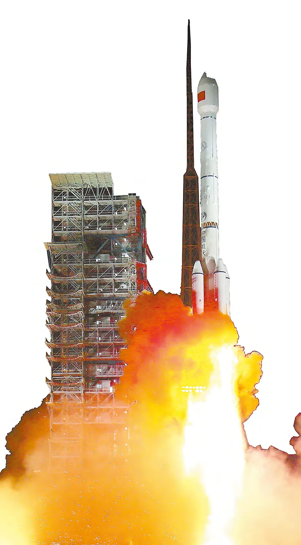
On November 5, China successfully launched two BeiDou-3 satellites via a single carrier rocket from the Xichang Satellite Launch Center in Sichuan Province.11月5日,两颗北斗三号卫星在西昌卫星发射中心成功发射。
北斗人给自己确定目标,要研制误差仅有10的-12次方的原子钟,通俗地讲,就是它每十万年只会出现一秒的误差。他们组织三支队伍同时开展研发,在基础理论、材料、工程等领域同步进行推进。
中国科学院武汉物理与数学研究所梅刚华团队,便是其中一支团队。20年来,他们没有正常休过一次长假。2008年前后,他们研制出具有完整自主知识产权的铷原子钟,打破西方技术垄断和封锁,用在“北斗二号”卫星上。
而现在用在北斗三号上的原子钟,提升到每300万年才会出现1秒误差的精度。建成后的北斗全球导航系统,能为民用用户免费提供约10米精度的定位服务、0.2米/秒的测速服务。
中国不可能像美国GPS那样,在全球建立地面站,于是,北斗三号采取星间、星地传输功能一体化设计,实现卫星与卫星、卫星与地面站的链路互通。整个导航系统的精度可以提升到两倍左右。
2017年,1400多个北斗基站遍布全国,上万台套设备组成星地“一张网”,国内定位精度全部达到亚米级,部分地区达到分米级,最高精度甚至可到厘米或毫米级。
后发自主创新
北斗人一步一个脚印,开创了很多只有北斗卫星才有的新技术和独特方案。
按照空间定位原理,对地球上一个目标点进行定位,至少需要3颗卫星;考虑到时间误差,精确定位至少需要4颗卫星。这就是GPS和格洛纳斯的工作原理和全球组网方案。
中国陈芳允院士,创造性提出“双星定位”建设方案。把地心视为一颗虚拟卫星、再发射两颗地球同步卫星构成星座,经地面控制中心计算处理,实现对地面目标的快速定位。中国能以最少的投入、最短的周期,投入卫星导航系统建设。
北斗造福世界
北斗系统已成功应用于测绘、电信、水利、渔业、交通运输、森林防火、减灾救灾和公共安全等领域。
交通部使用北斗系统,建立全国的交通监管系统,对危险品的运输车、旅游客车、长途客车实时监控。目前规模已达480多万辆。据2016年统计,事故率跟原来的同期相比,已经减少50%,人员的伤亡率也下降50%。
2016年,北斗系统已实现产值2000亿。以这次北斗三号的首次发射任务为起点,中国将迎来北斗三号卫星高密度发射。到2018年年底,将有18颗北斗卫星发射升空,到2020年,将完成30多颗北斗三号卫星的全球组网,实现全球服务。
如今,缅甸的农业、林业、土地规划,老挝的精细农业和病虫灾害监测管理,文莱的智慧旅游……北斗系统已覆盖巴基斯坦、沙特、缅甸等近30个“一带一路”沿线国家。♦

一名观众在“砥砺奋进的五年”大型成就展上体验北斗高精度导航驾驶A visitor experiencing BeiDou-navigated driving in an exhibition featuring “China’s outstanding achievements over the past fi ve years” in Beijing
The people at BeiDou have created many new techniques and unique solutions for BeiDou satellites by working steadily over the years.
According to the law of spatial orientation, when positioning a target point on the earth, it requires at least three satellites.In view of time error, accurate positioning requires at least four satellites. This has been the working principle and global networking solution for GPS and GLONASS (Russia’s global navigation satellite system).
Chinese expert Chen Fangyun creatively put forward the development scheme of “duelsatellite positioning.” According to this plan, the earth’s core is viewed as a virtual satellite,which forms a constellation with the other two geosynchronous satellites launched into the orbit. Then rapid positioning of a ground target can be realized after the computing process of the ground control center. As a result,China could start its construction of a satellite navigation system with minimum investment in the shortest time possible.
Since it was impossible for China to build ground stations around the world as what the US had done for GPS, BeiDou-3 adopts an integrated design for the transmission function between the satellites and the satellite-earth transmission function. This realizes the interflow between the links of satellite to satellite, and satellite to the ground station, with double the precision of older orientations.
By 2017, more than 1,400 BeiDou base stations have settled all over the country, whose tens of thousands of pieces of equipment compose a network between the satellites and the earth,realizing the level of sub-meter positioning accuracy nationwide,and decimeter accuracy in some places. The highest positioning accuracy may even reach the level of centimeter or millimeter.
BeiDou system has now been successfully employed in various fields including s u r v e y i n g a n d m a p p i n g,telecommunications, hydraulic engineering, the fi shing industry,transportation, forest fire prevention, disaster mitigation and relief, and public security.
The Ministry of Transport has set up traffic control systems across the country by means of the BeiDou system, so that they can have real-time monitoring on the carrier vehicles for hazardous materials, sightseeing buses, and inter-city buses. The number of the above vehicles has reached more than 4.8 million. However,according to the statistics in 2016,the accident rate, compared to the corresponding period of previous years, was reduced by 50%, and the casualty rate also dropped by 50%.
In 2016, BeiDou’s output value amounted to 200 billion yuan.Starting from the first launch of BeiDou-3, China has stepped into a period when more BeiDou satellites will be launched into the orbit. By the end of 2018,18 BeiDou-3 satellites will have been launched, and by 2020, a global network of more than 30 BeiDou-3 satellites will have been accomplished, realizing the aim of global services.
At present, the BeiDou system covers nearly 30 countries along the Belt and Road, benefiting,for instance, the agriculture,forestry, and land planning in Myanmar (Burma), the precision agriculture, and monitoring and management for diseases and pests in Laos, and the smart tourism in Brunei.♦
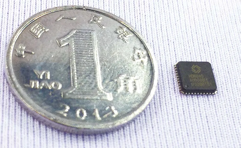
支持新一代北斗三号信号体制的高精度导航定位芯片与1角硬币的对比照片High-precision navigation and positioning chip supporting BeiDou-3 signal system in comparison with a one-jiao coin

通过北斗卫星定位系统获得的经纬度实时绘制的飞机飞行轨迹图Real-time fl ight path of an aircraft drawn with the latitude and longitude obtained via the BeiDou Navigation Satellite System
中国北斗惠全球
编/柏宁 译/刘洁
猜你喜欢
小哥白尼(神奇星球)(2022年3期)2022-06-06
中学生数理化·八年级物理人教版(2020年11期)2020-12-14
中学生数理化·八年级物理人教版(2019年9期)2019-11-25
当代陕西(2019年18期)2019-10-17
中学生数理化·八年级物理人教版(2018年4期)2018-06-27
中国军转民(2018年3期)2018-06-08
中国惯性技术学报(2017年1期)2017-06-09
百科探秘·航空航天(2016年9期)2016-12-01
太空探索(2016年12期)2016-07-18
太空探索(2016年3期)2016-07-12