
Liquefaction structures induced by the M5.7 earthquake on May 28,2018 in Songyuan,Jilin Province,NE China and research implication
2020-03-04 16:46ZhuFuShaoJianHuaZhongJohnHowellBingHaoXiWuLuanZeXuanLiuWeiMinRanYunFengZhangHongQiYuanJingJingLiuLiangTianNiGuanXianSongJinLinLiuWenXinZhangandBingZhao
Journal of Palaeogeography 2020年1期
Zhu-Fu Shao,Jian-Hua Zhong,John Howell,Bing Hao,Xi-Wu Luan,Ze-Xuan Liu,Wei-Min Ran,Yun-Feng Zhang,Hong-Qi Yuan,Jing-Jing Liu,Liang-Tian Ni,Guan-Xian Song,Jin-Lin Liu,Wen-Xin Zhang and Bing Zhao
Abstract An earthquake of magnitude M5.7 occurred in Yamutu village, Songyuan City, Jilin Province, NE China (45°16′12″N/124°42′35″E) on May 28, 2018, with a focal depth of 13 km. The epicenter is located at the intersection of the Fuyu/Songyuan-Zhaodong Fault, Second Songhua River Fault and Fuyu North Fault which lies northwest of Tancheng-Lujiang Fault (Tan-Lu Fault). The earthquake-induced widespread liquefaction structures and ground surface fissures within 3 km from the epicenter, caused serious disasters to the local surroundings. The visible liquefied structures include sand volcanoes, liquefied sand mounds, sand dikes and sand sills. Sand volcanoes can be divided into sand volcano with a crater, sand volcano without a crater and water volcano (no sand). Other soft-sediment deformation structures (SSDS) induced by the earthquake include deformation lamination, load and flame structures,deformation folds, dish structures, convolute bedding and water-escape structures. The formation process of the sand volcanoes comprises three stages: (1) building up excess pore-fluid pressure in the liquefied layer, (2) cracking of the low-permeable overlying layer, and (3) mixture of sand-water venting out of the ground surface. During the upward movement, the liquefied sand is injected into the low-permeable layer to form sand veins, sand sills and various types of deformation structures. Vertical distribution of seismic liquefaction structure can be divided into four zones: the thoroughly liquefied zone, the lower liquefied zone with SSDS, the upper liquefied zone with SSDS,and the ground surface liquefied zone. The liquefaction occurred at a burial depth of 2–5 m, and the thickness of liquefied sand is 2 m. NE-SW (35°–215°) trending compressive stress is possibly the seismogenic trigger of the Songyuan M5.7 earthquake that caused the fault (Fuyu/Songyuan-Zhaodong Fault) to reactivate. The study of the Songyuan seismic liquefaction structures gives insight into the prediction of modern earthquakes and disasterprone areas. Meanwhile it provides abundant basic material for studying earthquake-induced SSDS in both ancient and modern sediments. The research is obviously of great significance to reveal that the northern Tan-Lu Fault has entered a stage of active seismic activity since the twenty-first century.
Keywords: Earthquake, Soft-sediment deformation structures, Liquefaction structure, Sand volcano, Songyuan
1 Introduction
The formation of SSDS depends on three aspects: the susceptibility of unconsolidated sediment to liquidization, the triggers that change the physical state of sediment with low yield strength, and a sufficient amount of force (Allen 1986). The deformation mechanism varies with the properties of the materials. For elastic and plastic sediments, a large enough stress that exceeds the yield strength can lead to deformation. For viscous materials, liquefaction is the main deformation mechanism.Viscous materials are easily deformed because of their high thixotropy and sensitivity to liquefaction and fluidization (Owen 1987). Shanmugam (2016) pointed out that there are at least 21 triggers causing softsediment deformation structures, including short-term events, intermediate-term events and long-term events,among which, earthquakes were believed to be the most important trigger for the formation of SSDS.
Liquefaction structures are one kind of common SSDS(Shanmugam 2017). It includes sand dikes, sand veins,sand pillars,sand(mud)volcanoes(sand boils),sand tubes(sand pipes),sand blow,sandcusps,deformation folds,deformation lamination, load structure, dish structure, convolute bedding, diapirs, draw-in structure, pseudonodules and other water-escape structures (Lowe and LoPiccolo 1974; Lowe 1975, 1976; Allen 1977, 1982; Owen 1987,1995; Obermeier 1996; Rodríguez-Pascua et al. 2000;Takahama et al. 2000; Massari et al. 2001; Tuttle 2001;Kholodov 2002; Lu et al. 2006; Glennie and Hurst 2007;Moretti and Sabato 2007; Bonini 2009; Chen et al. 2009;Gibert et al. 2011; Owen and Moretti 2011; Owen et al.2011; Ross et al. 2011; Rowe 2013; Su et al. 2014; Valente et al. 2014; Yi et al. 2015; Mazumder et al. 2016; Oppo and Capozzi 2016; Ulvrova et al. 2016; Du and Yu 2017;Hurst and Vigorito 2017; Zhong et al. 2018). Liquefaction can even trigger a giant sand injection complex(Satur and Hurst 2007;Grippa et al.2019;Su et al.2019).
Liquefaction can be distinguished into the three types of static,impulsive and cyclic(Owen 1987),which can occur in environments such as glaciers, deserts, intermountain depressions, rivers, deltas, tidal zones, continental slopes and submarine fans (Kuribayashi and Tatsuoka 1975;Alfaro et al. 1997; Moretti e al. 2001; Moretti and Sabato 2007; Shi et al. 2007; van Loon 2009; Alfaro et al. 2010;Moretti and Ronchi 2011; van Loon and Maulik 2011;Phillips et al. 2013; Owen and Santos 2014; Ravier et al.2015; Koç-Taşgın and Diniz-Akarca 2018; Zhong et al.2018), but mainly in lakes and oceans. Some authors reported the possibility of liquefaction on Mars (Mahaney et al. 2004; Wang et al. 2005). Liquefaction occurs mostly in clastic and carbonate sediments (Su et al. 2014) and in bedrock (Friese et al. 2011). Earthquakes, volcanic eruptions,meteorite impacts,tsunamis and storm waves,depositional loading, thawing of ice-rich frozen soils, glacier melting, tides, flooding, slide and slump, turbidite, piping and diversion of runoff, groundwater movement, sea level changes, diapirism, gas leaks, digenesis and biological activities can trigger liquefaction (Burne 1970; Allen and Banks 1972; Owen 1987; Obermeier 1996; Harris et al.2000; Murton et al. 2000; Moretti et al. 2001; Mahaney et al.2004;Mazumder et al.2006,2016;Zhong et al.2006,2008, 2018; Glennie and Hurst 2007; Greb and Archer 2007; Owen and Moretti 2008, 2011; Mei et al. 2009; van Loon 2009; Zhong and Liang 2009; Alfaro et al. 2010;Owen et al.2011;Chen and Lee 2013;Li et al.2013;Miyakawa et al. 2013; Phillips et al. 2013; Rowe 2013; Tian et al. 2014; Owen and Santos 2014; Shao et al. 2014a;Ravier et al. 2015; Ulvrova et al. 2016; Capaccioni et al.2017;Du and Yu 2017;Feng 2017;Feng et al.2017;Hurst and Vigorito 2017; Ko et al. 2017; Koç-Taşgın and Diniz-Akarca 2018).
Earthquakes are one of the most important triggers leading to liquefaction and fluidization. During an earthquake, unconsolidated saturated sediments are affected by the seismic shear waves and the internal texture is rearranged, thus forming viscous fluids with no yield strength. Then effective stress transferring caused by liquefaction leads to excessive intergranlar pore-fluid pressure which can last for seconds. Clastic particles redeposit after transitory seismic liquefaction (Allen 1982;Owen 1987; Obermeier 1996; Obermeier and Pond 1999; Tuttle 2001; Owen and Moretti 2011). Pore-fluid pressure gradually increases due to cyclical seismic shock and then exceeds the overburden pressure or fracturing pressure, resulting in pressure release and fluidization. Various deformation structures occur because of the movement of water and sand (Obermeier 1996; Owen et al. 2011; Shao et al. 2014a, 2014b,2014c).
The liquefaction intensity is related to the magnitude,distance of the epicenter, focal depth and duration of earthquakes, and is influenced by the grain size, thickness, degree of consolidation of the liquefiable sand layer and the thickness of the overlying low-permeable layer(Burne 1970; Obermeier 1996; Moretti et al. 1999;Valente et al. 2014).
Liquefaction occurs most easily in fine and coarse sand(Owen and Moretti 2011) but has also been reported in sandy conglomerate (Takahama et al. 2000). Generally,the minimum earthquake magnitude causing liquefaction is M5–6 (Yang 1985; Allen 1986; Obermeier and Pond 1999; Ko et al. 2017), and most of the liquefaction occurs at a depth of less than 5 m (Obermeier 1996;Rodríguez-Pascua et al. 2000; Owen et al. 2011; Berra and Felletti 2011;Zhao 2012; Wei et al. 2016).
An earthquake of M5.7 occurred in Yamutu village,Songyuan City of Northeast China (45°16′12″N/124°42′35″E) on May 28, 2018, with a focal depth of 13 km,followed by a series of M2–3 aftershocks in the following days. Liquefaction and fluidization induced by the earthquake distributed in a range of 3 km and the most common type is sand volcano. In this paper, the types, their relations and spatial distribution of liquefaction structures are introduced in detail, and their generation mechanism is illustrated to provide materials for seismic researches of ancient time and modern time as well.
2 Results
Lots of sand volcanoes and other liquefaction structures were found which were induced by the Songyuan M5.7 earthquake that happened on May 28, 2018 within 3 km from the epicenter. Sand volcanoes, sand mounds, sand dike, and sand sill were the most common and main seismic liquefaction structures. Sand volcanoes can be divided into three types according to their morphologies and structures: sand volcano with a crater, sand volcano without a crater, and water volcano (no sand). Vertically,the liquefaction structure distribution of the M5.7 earthquake in Songyuan has obvious stratification, which can be divided into 4 zones: the thoroughly liquefied zone,the lower liquefied zone with SSDS, the upper liquefied zone with SSDS, and the ground surface liquefied zone.From the characteristics of ground fissures and liquefaction structures, it is inferred that the Fuyu/Songyuan-Zhaodong Fault, which is part of the northern Tan-Lu Fault, was the major seismogenic fault. Therefore, the Songyuan M5.7 earthquake reveals that the northern Tan-Lu Fault has entered a stage of active seismic activity since the twenty-first century.
3 Geological setting
Songyuan is located in the northwest of Jilin Province and geomorphologically belongs to the Songnen Plain area and tectonically is in the central depression zone of the Songliao Basin, west of Northern Tan-Lu Fault. The Songliao Basin was a Meso-Cenozoic continental polycyclic superimposed basin sandwiched by the North China Plate, the Siberian Plate and the Pacific Plate(Ge et al. 2010; Meng et al. 2012; Wang et al. 2015b; Han et al. 2018), with the Nenjiang-Kailu Fault and the Daxing’anling Orogen to the west, the Yilan-Yitong Fault and the Zhangguangcailing Orogen to the east, the Nemor River Fault and the Xiaoxing’anling Orogen to the north, and the Chifeng-Kaiyuan Fault and the Yanshan Orogen to the south (Fig. 1). The tectonostratigraphic units of the NNE trending basin are featured by block fault, interior sag and structural inversion, filling with clastic and volcanic deposits. The direction of the fault in the basin is mainly NNE-NE and NNW-NW (Zhang et al. 1997; He et al. 2011).
Faults around Songyuan are frequently active (Fig. 2),among which the most important are Fuyu/Songyuan-Zhaodong Fault, Second Songhua River Fault, Fuyu North Fault, Gudian Fault, and Chaganhua-Daozijing Fault (Yang et al. 2010; Shao et al. 2015; Xue et al. 2015; Liu et al.2017b;Pan et al.2018).These faults are decribed below.
1) Fuyu/Songyuan-Zhaodong Fault. Starting from Zhaodong in the north and ending at Huaide in the south, the early–middle Pleistocene active Fuyu/Songyuan-Zhaodong Fault is the boundary of the central sag and south-east uplift, striking NE, inclining SE and dipping 70°–80° (Liu et al. 2017b; Pan et al. 2018).
2) Second Songhua River Fault. It was active during early–middle Pleistocene period starting from Da’an in the west and ending at Chongshan in the east with a length of more than 500 km, striking NW,inclining NE, dipping 70°–80° (Yang et al. 2010).
3) Fuyu North Fault. A branch fault of the Fuyu-Zhaodong Fault. This 30-km-long fault has been active since the Holocene with striking EW, inclining S, dipping 70°–80° (Liu et al. 2017b).
4) Gudian Fault. A branch fault of the Fuyu-Zhaodong Fault. This 60-km-long fault has been active since the Holocene with striking NW–SW, inclining NE–SE (Shao et al.2015; Liu et al. 2017b).
5) Chaganhua-Daozijing Fault.The southern branch of the Fuyu-Zhaodong Fault. This 30-km-long fault has been active since the Holocene with striking NW–SW, inclining SE–NE (Liu et al. 2017b).
Songyuan area is located in the hinterland of the Songnen Plain. The Quaternary loose sediments are 80–100 m thick, and mainly consist of black silt and fine sand interbedded deposits. The succession from bottom to top is Lower Holocene Wenquanhe Formation, Middle Holocene Tantu Formation and Upper Holocene Guojiadian Formation, respectively (Guo et al. 2007; Zhao 2010). The burial depth of the underground water table is generally less than 5 m (Tian et al. 2011; Pan et al.2018). The loose sediments on the shallow surface around Yamutu village (Guojiadian Formation) can be divided into five stratigraphic units according to the results of three drilling wells approximately 1 km from the epicenter (Fig. 3). From top to bottom these units are:unit 1: Black clay layer rich in humus (black soil) with a thickness of 50–70 cm; unit 2: 45–60-cm-thick light brown silty clay; unit 3: Orange-brown palaeoweathering crust depositional clay with a thickness of 10–15 cm, which can be traced in the whole area; unit 4:10–15-cm-thick light gray silty clay; unit 5: Light yellow well-sorted and rounded fine sand and siltstone with a thickness of approximately 20 cm.
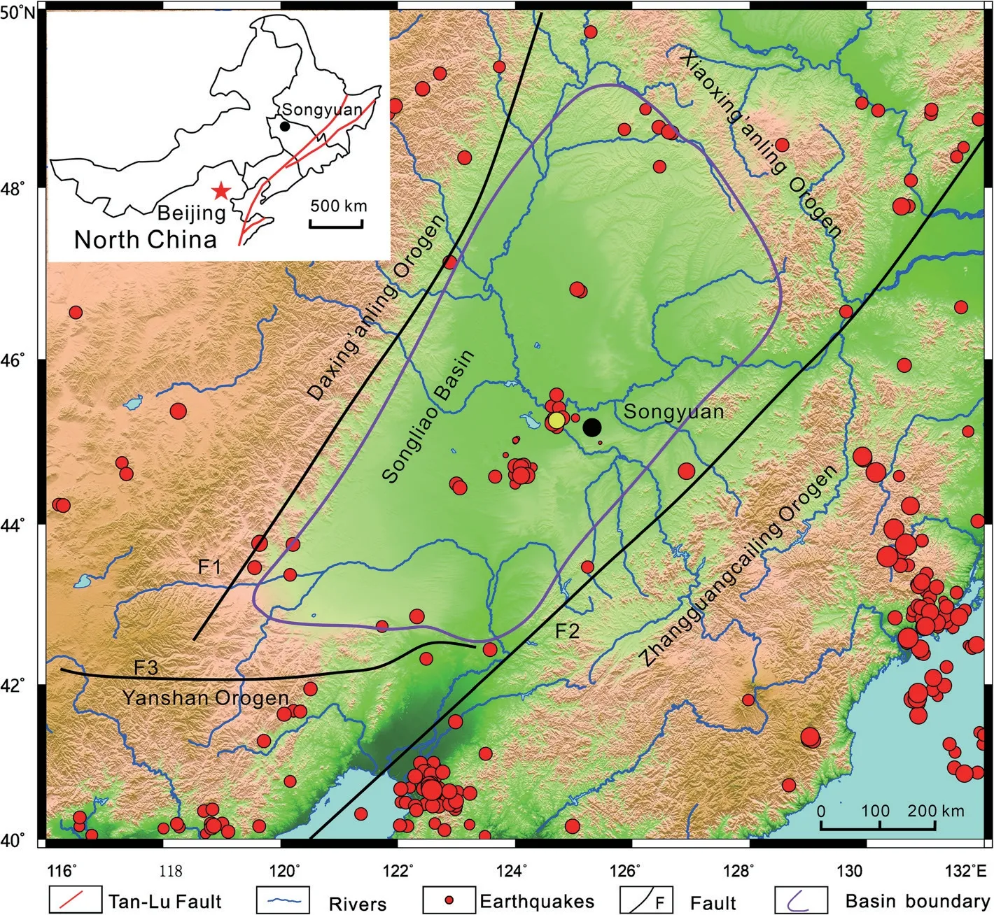
Fig. 1 Geographic and tectonic location of Songyuan (black dots), Jilin Province, NE China. F1: Nenjiang-Kailu Fault; F2: Yilan-Yitong Fault; F3:Chifeng-Kaiyuan Fault. The red dots are the epicenter of earthquakes that happened in the Songliao Basin and their surrounding area since 1976,and the yellow dot is the epicenter of the M5.7 earthquake in Yamutu village,Songyuan on May 28, 2018
Earthquakes happened frequently in Songyuan, with up to 77 of larger than M2 since 2006, particularly after 2013 (Fig. 4). The largest recorded earthquake in Songyuan was the M6¾ Qianguo earthquake in 1119 AD,with its epicenter at the intersection of the Fuyu/Songyuan-Zhaodong Fault and the Second Songhua River Fault (Wu 1991). Two M5.5 earthquake clusters occurred in Chaganhua town in Songyuan in March 2006 and October 2013, with the epicenter located at the intersection of the Gudian Fault and the Chaganpao-Daozijing Fault zone (Shao et al. 2015; Pan et al. 2018).The epicenter of the M5.7 earthquake on May 28, 2018 was located at the intersection of the Fuyu/Songyuan-Zhaodong Fault and the Second Songhua River Fault.
4 Earthquake-induced liquefaction structures
Songyuan M5.7 earthquake caused severe liquefaction of loose sediments on the surface (stratigraphic unit 5 in Fig. 3), leading to the eruption of sand volcanoes of several meters high and more than 1 m in diameter. During or shortly after the earthquake (within a few minutes),the excessive pore fluid pressure in the liquefied layer broke through the weight or fracture pressure of the overlying layer and poured out of the surface with sand distributing along caves or cracks. Sand volcanoes can last up to half an hour and can vent up to 6–7 m if the pressure is sufficiently large (Obermeier 1996). The ejected sand and mud accumulate around the crater after the eruption, forming various types of sand volcanoes, as shown in Fig. 5; more than 60 sites of sand volcanoes were found after the M5.7 earthquake within 3 km around the epicenter. We conclude through detailed analysis that the stratigraphic unit 5 was considered to be the main liquefied layer, and the stratigraphic units 1–4 were impermeable or low-permeable cap layers.
4.1 Sand volcanoes
A sand volcano, also named a sand boil (Lowe 1975;Obermeier et al. 1992; Obermeier 1996; Li et al. 1996;Moretti et al. 1999; Massari et al. 2001; Tuttle 2001;Kanıbir et al. 2006; Bhattacharya et al. 2011; Moretti and Ronchi 2011; Ross et al. 2011; Yamaguchi et al. 2012;Capaccioni et al.2017),is the most common and dominant seismic liquefaction structure type in Songyuan.Sand volcanoes are assembled in groups and in a certain dominant direction (Fig. 5), and can be divided into three types according to their morphologies and structures.

Fig. 2 Faults distribution around Songyuan (modified from Liu et al. 2017b, the red pentagram is the epicenter of the Songyuan M5.7 earthquake)
4.1.1 Sand volcano with a crater
During the process of liquefaction and fluidization, overpressure fluid carries the liquefied sand during upwelling process forming channels (cavities) along the fracture zone or stress-reduced zone (Lowe and LoPiccolo 1974;Lowe 1983; Owen 1996; Harris et al. 2000; Owen 2003;Massari et al. 2001; van Loon 2009; Yamaguchi et al.2012; Phillips et al. 2013; Su et al. 2014), and then pours out of ground surface, which is a sand volcano eruption.The eruption ends as the energy reduces, creating crater-like depressions (Collinson et al. 2006), draw-in structures (Takahama et al. 2000), and sand blows(Obermeier 1996; Tuttle 2001; Owen and Moretti 2011).After fluid pressure is released, the sands deposit as lobes, which are of round shape in plain view and conical or dome-shaped vertically, with varying widths outside and inclined lamination inside (Collinson et al.2006).
The scale of a sand volcano is directly related to the magnitude and epicentral distance. Generally, the larger the earthquake magnitude is and the smaller the epicentral distance is, the larger scale the sand volcano is. It has been reported that the M5.8 earthquake that occurred in Songyuan in 2013 induced an area of more than 300 m2of sand volcanoes (Wei et al. 2016).
The maximum diameter of the sand volcano caused by the Songyuan M5.7 earthquake exceeded 12 m (Fig. 6a).The scale of sand volcanoes decreased as the epicentral distance increased. The minimum diameter of the sand volcano was only 5 cm. The common sand volcano scale was 2–8 m in diameter, and the crater was usually 0.5–1 m in diameter. The thickness of the sand volcanic deposit was large around the crater and gradually decreased outwards, with a variation range of 2–50 cm.The distribution of sand volcanoes can be divided into symmetrical and asymmetric types. Generally, the distribution of sand bodies is symmetrical, widely distributing in a flat surface without obstacles (Fig. 6b); whereas distribution of sand bodies is asymmetric when affected by high topographic fluctuation, surface fractures and obstacles (Fig. 6c, d). In addition, the symmetrical shape of the sand volcano may be affected by the wind direction and other factors. The sand volcanoes were distributed either in isolation (Fig. 6a, d) or in groups (Fig. 6b, c).Volcanoes distributed in groups generally had a dominant orientation, and the dominant distribution direction in Songyuan was N-S, followed by NW-SE (Fig.5).

Fig.3 Lithologic profile of shallow sediments in the Songyuan M5.7 earthquake area(the drilling site is A in Fig.5)
Influenced by periodic seismic waves, sand volcanoes also erupt periodically. The sand flows laterally after the eruption to form inclined lamination, as shown in Fig. 7.The morphology of inclined lamination is essentially consistent with that of the sand volcanic deposit, which points out from the crater’s center to distal end. In the interior, the lamination mostly extends to the interior of the sand volcanic channel due to the refluxing effect of eruption, forming the draw-in structures (Takahama et al. 2000) and gully at the inner edge of the crater (Fig.6b). The thickness of inclined laminae within the sand volcanoes varied from (Fig. 8a–c) 0.5 cm to 5 cm and normally-graded bedding developed (Figs. 7 and 8b).This represented a single eruption process in which pore-fluid pressure gradually decreased (Rodríguez-Pascua et al. 2015), coarser sediments deposited at the beginning, and then finer sediments deposited as energy reduced. In the vertical profile, sand volcanic sedimentary lenses are often mistaken as beddings, and inclined layering is mistaken for cross-bedding (Collinson et al.2006).
Upwelling water and sand erode the clay of the surrounding sidewall, forming mud clasts, which erupt and deposit together with sand and water (Obermeier 1996;Su et al. 2014). These mud clasts are often well-sorted and elliptical, forming imbricate structures after deposition (Fig. 7; Fig. 8d). Mud clasts may not occur in sand volcanoes in a few cases(cf. Li et al. 1996).
4.1.2 Sand volcano without a crater
This type of volcanoes is often in the shape of a mound or dune with no craters. They are relatively thicker in the center and wedge out to all sides, and circular or elliptical in the plane and lenticular or conical in vertical direction. Most sand volcanoes without craters are distributed in isolation, while others are linear, 0.2–10 m in diameter and 0.1–0.6 m in height. As shown in Fig.6d, the elliptical sand volcano without a crater is approximately 0.5 m high, with the long axis direction close to N-S.

Fig.4 Earthquake distribution(M ≥2)in Songyuan area since 2006(data up to June 3,2019)
Two conditions are necessary to form sand volcano without a crater. First, there must be sufficient supply of liquefied sand, so that the volcanic vent formed by erupting can be filled in time. Second, the excessive pore-water pressure must be appropriate, which can make the fluid only eject to the ground surface without causing a large crater. Therefore the continuous sandblasting forms sand volcanoes without craters.
4.1.3 Water volcano (no sand)
The presence of water volcanoes indicates that there is no sand ejection and deposition during the eruption process. When the earthquake is over, one crater is formed with no sand deposition. As shown in Fig. 9, the water volcano crater is nearly circular with a diameter of 2.2 m and a settlement of 45 cm. Concentric ring normal faults are developed on the rim of the crater, and it is inferred that inside the crater, several groups of faults with different directions developed.

Fig. 5 Distribution of liquefied sand volcanoes induced by the Songyuan M5.7 earthquake (A–I are locations of detailed research and photo collection sites)

Fig. 6 Morphology and combination features of liquefied sand volcanoes induced by the Songyuan M5.7 earthquake. a An isolated sand volcano, approximately 12 m in diameter with a crater of approximately 1.3 m in diameter (photo was taken from site A in Fig. 5); b Sand volcanoes distributed in group with craters of 0.7–1.0 m in diameter, concentric ring terraces formed by multistage sand volcano eruptions, gully developed in the crater margin and runoff on the surface of sand volcano deposition (photo was taken from site B in Fig. 5); c Small-scale linear sand volcano distributed in groups with a thickness of 2 cm (photo was taken from site D in Fig. 5); d Hill-shaped isolated sand volcano with no crater,3.1 m long,1.6 m wide,and 0.45 m high,with the direction of long axis close to N-S(photo was taken from site E in Fig.5)

Fig.7 Sketch of the internal structure of a sand volcano(modified from Obermeier 1996; Su et al.2014)

Fig. 8 Internal structure of a sand volcano caused by the Songyuan M5.7 earthquake. a Laterally inclined bedding and load structure of sand volcanic deposits; b Normal graded bedding and inclined lamination in sand volcanic deposits;c Internal inclined lamination of the sand volcano;d The mud clasts and load structure inside the sand volcano. Photos were taken from the interior of a small exploratory trough (with a depth of approximately 30 cm), which located at about 1 m on the flank of a sand crater(site A in Fig.5)
Except for one water volcano found in the study area,there were no reports of this type by other researchers.Special geological and hydrodynamic conditions are needed for the formation of this type. First, sands must be inadequate or don’t exist in the liquefaction area, as well as in the upwelling fluid. Second, the pore-water pressure should be just appropriate, making it impossible for sand to erupt out of the surface except when carried by water. The dynamic process of this type of volcanic deposition requires further detailed study.
4.1.4 Model of forming mechanism
The sand volcanoes induced by earthquakes mainly form in three stages as follows: the preseismic, the coseismic and the postseismic (Fig. 10).

Fig.9 A water volcano caused by the Songyuan M5.7 earthquake(photo was taken from site C in Fig.5)

Fig.10 Sketch of the formation process of a sand volcano induced by an earthquake (modified from Rodríguez-Pascua et al.2015)
In the preseismic stage, the water-saturated unconsolidated sediments are dominated by well-sorted and rounded fine sands, which are overlain by low-permeable clay and silty clay. The thickness of the overlying layer must be less than a certain value to induce liquefaction(Fig. 10a). During the coseismic stage, the ground shakes under the influence of seismic wave shear force, resulting in cracks. The water moves up because of liquefaction,which gathers at the interface between the clay layer and sand layer (Fig. 10b). The sands redeposit and become tightly packed after one single liquefaction event. The upward buoyancy generated by the gradually increasing excessive pore-water pressure makes the ground surface shake continuously and cracks further expand (Fig. 10c).During the postseismic stage, hydraulic fractures are generated once the excessive pore-water pressure exceeds the hydrostatic pressure, at which point water erupts out and forms a volcano (Fig. 10d). Later, extensive liquefaction and fluidization are caused, making sands vent out with upwelling water through the crater forming a sand volcano(Fig.10e).More fractures were formed in the process that allows sand and water to continue to erupt and form sand volcanoes (Fig. 10f). When all the seismic energy is released,the excessive pore-water pressure decreases to be less than the hydrostatic pressure,which ends liquefaction and fluidization. As the movement of the surface water and sands stops,the sand volcanism comes to an end(Fig.10g).
4.2 Sand mounds
The Songyuan M5.7 earthquake induced a wide range of sand mounds (Fig. 11). Sand mounds are formed in two environments: one is on the dune approximately 2 m above the ground surface, which is dominated by fine sand and silt (Fig. 11a). The other occurs on sand volcanoes, which can form in both the crater interior and the lateral lobes (Fig. 11b, c). The shape of the sand mounds is similar to that of a volcanic cone, with or without a crater. They are round in plain view and lens-like in vertical profile, 3–15 cm in diameter and 3–8 cm in height.Sand mounds are most commonly developed in groups,and the sand piles are relatively coarse grained and gradually transfer to finer sands towards the cone top. Small inclined lamination can be found inside the sand mounds,with the tilting angle of approximately 30°.

Fig. 11 Sand mounds induced by the Songyuan M5.7 earthquake. a An isolated sand mound, 13 cm in diameter (photo was taken from site C in Fig. 5); b An isolated sand mound inside a sand crater, 4–7 cm in diameter (photo was taken from site B in Fig. 5); c Groups of sand mounds on the flanking surface of a sand volcano,3–5 cm in diameter(photo was taken from site B in Fig.5)
Sand mound is a special type of sand volcano (Su et al.2014), which is also induced by earthquake liquefaction.However special conditions are required for forming this type of structure. First, sand mounds are formed by sand layers rather than low-permeable clay, and the sands within the layers are well-sorted and rounded, which are easy to liquefy. Second, the excessive pore-water pressure must be appropriate, as a too small pressure cannot induce eruption while a too large one leads to large sand volcanoes formation. Otherwise, the sand layer is in undersaturation condition when sand mounds form,which means sands are unable to flow or just able to be transported for a short distance after ejection. Sands accumulated due to the weight near the crater with coarser sands distributing at proximal end, which is different from the deposition feature of conventional sand volcanoes.
Due to liquefaction, the water and sand moving up to the clay surface continue upward migration and vent out of the sand dune surface to form the first type (Fig. 11a).The water and sand continuously erupt to the surface to from the second type of sand mound when excessive pore-water pressure inside the sand volcano is just appropriate. This type of sand mound is of small scale and without a crater due to the reduced energy (Fig. 11b, c).
4.3 Sand dike and sand sill
The scale of the sand dike and sand sill is controlled by the magnitude and epicenter distance. The width of the sand dike caused by the Songyuan M5.7 earthquake is 3–11 cm, and the lateral extension length is 0.2–2 m.The thickness of the sand sill is 5–15 cm, and the lateral extension is more than 50 m (Fig. 12). Generally, a large thickness of the liquefied sand layer, a moderate thickness of the overlying low-permeable seal and a high groundwater level favor the formation of sand dikes and sills. Sand dikes and sills are two of the most important structures caused by earthquakes (Obermeier and Pond 1999; Obermeier and Dickenson 2000; Rodríguez-Pascua et al. 2000; Tuttle 2001; Shi et al. 2007; van Loon 2009;Berra and Felletti 2011; Topal and Özkul 2014; Hilbert-Wolf et al. 2016; Ko et al. 2017; Brogi et al. 2018; Zhong et al. 2018).
There are three mechanisms for the formation of sand dikes and sand sills: hydraulic fracturing, lateral spreading and surface oscillation (Obermeier and Pond 1999).As liquefaction intensifies, the sand dikes and sand sill evolve into a large sand intrusive complex that can be tens of meters thick, extending up to thousands of square kilometers (Satur and Hurst 2007; Zhong et al.2018; Grippa et al. 2019).

Fig. 12 Liquefied sand dike and sand sill induced by the Songyuan M5.7 earthquake. a Columnar liquefied sand dike, 3–7 cm wide, 10 cm high,filling a vertical surface fracture (photo was taken from site A in Fig. 5); b Liquefied sand dike in a shallow drilling core with a burial depth of 45 cm (photo was taken from site A in Fig. 5); c Liquefied sand dike, cloud-like (photo was taken from site A in Fig. 5); d Liquefied coarse-grained sand dike with gravel at a burial depth of 1.1 m (photo was taken from site B in Fig. 5); e Sand sill, 7–15 cm thick, 55 cm deep from the surface(photo was taken from site G in Fig.5)
In addition to forming sand volcanoes, the liquefied sand invades the overlying cap layer, which tends to develop along the volcanic channel and the interface between the sand and clay, as well as the interface of various lithologies within the clay layer (Fig. 3). The direction and shape of sand dikes can be various, cloudlike, floating band, mushroom-like, columnar, etc. Sand sills are one kind of sand dikes that develop horizontally or parallel to the bedding and are generally larger than the normal size of sand dikes.
4.4 Other liquefaction-associated structures
There are some other soft-sediment deformation structures induced by earthquake liquefaction, such as load structure (Alfaro et al. 1997, 2010; Owen et al. 2011; Tian et al. 2014; Topal and Özkul 2014), flame structure(Pisarska-Jamroży et al. 2019), sand pillar (Lowe and LoPiccolo 1974; Mount 1993; Moretti et al. 1999; Valente et al. 2014; Oppo and Capozzi 2016), slump fold (Alsop and Marco 2011; Martín-Chivelet et al. 2011; Ko et al.2017), convolute bedding (Allen 1977; Obermeier 1996;Alfaro et al. 2010; Kundu et al. 2011), dish structure(Owen 1987; Alfaro et al. 2006), water-escape structure(Lowe 1975, 1976; Owen 1996; Moretti et al. 1999; Gibert et al. 2011) and so on. The soft-sediment deformation structures found in this study include load structure,flame structure and deformation bedding(Fig.8a,c,d;Fig.12a).
5 Vertical succession across the liquefied zone

Fig. 13 Sketch of the vertical liquefaction structures distribution zones and 3D liquefaction model for the Songyuan M5.7 earthquake (modified from Collinson et al.2006)
Vertically, the liquefaction structure formed in Songyuan M5.7 earthquake distributes in four obvious zones from bottom to top (Fig. 13): (1) Thoroughly liquefied zone.Fine unconsolidated sand with a large thickness is easily liquefied under the influence of seismic shear stress. The groundwater table is also located in this zone,generally at a depth of 2–5 m. One criterion for the formation of liquefaction is that the unconsolidated sand is watersaturated. Thus, the groundwater table should not be too low; otherwise, no liquefaction will occur. Deformation bedding, convolute bedding and water-escape structure can also be found in this zone. (2) Lower liquefied zone with SSDS. It is located at the lower part of the overlying low-permeable clay, closer to the sand layer. Affected by liquefaction and fluidization, high pore-pressure fluid and sand mixture upwells through the lithologic boundary and invade into the overlying clay to form sand dikes, sand sills, associated deformation beddings and load structures.(3) Upper liquefied zone with SSDS. It is located near the surface. Influenced by fractures, lithologic interfaces and beddings,the upwelling water with sand and clay particles intrudes into the clay layer to form sand dikes and sand sills, as well as associated deformation beddings and load structures.(4)Ground surface liquefied zone.The main liquefaction structures are sand volcanoes, sand mounds,sand dikes, load structures, and so on. Based on the regional geological characteristics, the 3D liquefaction model of Songyuan M5.7 earthquake is summarized in Fig.13.
6 Discussion
Songyuan area has been seismically active since 2006, especially in 2013, and an M5.8 earthquake cluster occurred in the Qianguo area, indicating an active tectonic movement. Some researchers proposed that the activity of the NE-SW trending and NW-SE trending faults was the focal mechanism (Chen et al. 2015; Li and Wang 2018). However, different specific faults were determined as the seismogenic faults (Fig. 1b), such as the Tongyu-Changchun Fault (Xue et al. 2015), the Second Songhua River Fault (Yang et al. 2010), the Gudian Fault (Shao et al. 2015), the Fuyu/Songyuan-Zhaodong Fault (Wang et al. 2015a; Liu et al. 2017b), and the Chaganhua-Daozijing Fault (Pan et al. 2018). It was also reported that the earthquakes can be caused by the exploration and production activities of oil companies (Liu et al.2017a). Therefore, many controversies have made it difficult to draw a conclusion.
A normal ground fault, the Yamutu Fault in this paper developed near the epicenter after the Songyuan M5.7 earthquake (Fig. 5). As shown in Fig. 14, the fault struck NE35°, 1.5–2.8 m in width, with a fault distance of 10–30 cm. The Yamutu Fault is characterized by a typical double-fault graben structure, which reflects the release of seismic stress to the surface. Tensile fissures developed widely around the earthquake zone, and the scale and distribution density of fissures were larger surrounding the Yamutu Fault compared to other areas neighbouring the earthquake zone (Fig. 15). The fissures can be divided into two types. One type was conjugate joints,which occur in pairs, acting as tracking tension joints,and the joint trends of the two groups were 0°–180° and 80°–260° (Fig. 15a, a’). The other type of tensile fissure was 0°–180° dominant in the direction, with a stable distribution of approximately 1 m,0–4 cm in width, extending over 50 m. Except for a few, most of the fissures were not filled with sand (Fig. 15b). Based on the regional geological setting,ground fault type and extension direction, and the conjugate joints after the earthquake,it is preliminarily judged that the regional stress field for the M5.7 earthquake in Songyuan on May 28, 2018 is characterized by its maximum compressive stress with a main direction of 40°–220°, and its minimum tensile stress with a main direction of 130°–310° (Fig. 15c). The extension direction of the Yamutu Fault is essentially the same as that of the Fuyu/Songyuan-Zhaodong Fault (Fig.1b). It is speculated that the Fuyu/Songyuan-Zhaodong Fault is a seismogenic fault, however further research is needed to verify this viewpoint.

Fig. 14 Yamutu Fault formed after the Songyuan M5.7 earthquake. a Double-fault graben structure in Yamutu Fault (photo was taken from site A in Fig.5); b Local feature of Yamutu Fault(magnification of the rectangle in a), cutting off the road(photo was taken from site H in Fig.5)

Fig. 15 Ground fissure and stress field pattern of the Songyuan M5.7 earthquake. a Tracking tension joints; the extension directions are 0°–180°and 80°–260°, respectively (photo was taken from site I in Fig. 5); a’ Sketch of a; b Ground fissures with extension directions of 0°–180° (photo was taken from site I in Fig.5); b’Sketch of b; c Model diagram of the stress field in the Songyuan M5.7 earthquake area
The Second Songhua River in the Songnen Plain flows through Songyuan, which is less than 500 m from the epicenter of the M5.7 earthquake. The average water level of the river is 129.32–134.95 m (Tian et al. 2014).The altitude around Yamutu village is 128–137 m. The ground ice in this area melts late, and the burial depth of the groundwater table in the earthquake zone is relatively shallow, which is estimated to be 2–5 m deep. The cyclic shear force generated by seismic activities is greater than the initial liquefaction shear force at this depth (see Obermeier 1996: Fig. 3). Another important condition for an earthquake-induced liquefied sand volcano is that the impermeable layer should not be too thick. Sufficient sand thickness is a prerequisite for liquefaction. A thick seal layer increases the load pressure and shear strength so that liquefaction cannot occur.The thickness of the sealing layer is usually 1–5 m, and may be up to 16 m (Obermeier and Pond 1999). The thickness of clean unconsolidated sands under the clay layer in the Songyuan area exceeds 20 m (Fig. 3: Unit 5).According to the China earthquake intensity scale(1980) (Lu 1981), M5.7 of Songyuan earthquake was VII.According to the research method of Ishihara (1985)(Obermeier and Dickenson 2000), the surface acceleration of the Songyuan earthquake was 0.17 g (g is the gravity acceleration), and it was concluded that the thickness of the liquefied sand zone of the Songyuan M5.7 earthquake was approximately 2 m.
The range of surface liquefaction is controlled by the magnitude and focal depth.According to different formulas or charts of the correlation between the maximum liquefaction epicenter distance and magnitude proposed by different researchers, the maximum liquefaction radius of the Songyuan M5.7 earthquake was 2.878 km(Kuribayashi and Tatsuoka 1975), 2–10 km (Obermeier and Pond 1999), and 4–13 km (Tuttle 2001; Bonini 2009), respectively.In this study,through field investigation and calculation, we found that the maximum liquefaction radius of the Songyuan M5.7 earthquake was 3 km.
7 Research significance
The liquefaction structures induced by the Songyuan M5.7 earthquake provide a good example for studying modern earthquakes. Liquefaction-related deformation structures can occur in a variety of sedimentary environments and can be triggered by a variety of factors(Moretti et al. 2016; Shanmugam 2016),of which the identification of earthquake genesis is a topic of research interest yet remains challenging. Our study provides three-dimensional spatial parameters for the analysis of palaeoearthquakes and liquefaction structures(Tuttle 2001),which makes up for the shortcomings of experimental simulation (Nichols et al. 1994; Owen 1996; Moretti et al. 1999; Ross et al.2011; Tian et al. 2014). Liquefaction structures are also important in restoring earthquake magnitude.
Songyuan is located in a seismically active zone,and frequent earthquakes have brought serious disasters to local agriculture and hydrocarbon exploration and production activities. Research on earthquake liquefaction structures can predict disaster-prone areas and influencing areas and thus can guide local industrial and agricultural production,construction and oil field exploration and production dynamic monitoring.
Songyuan is located at the hinterland of the Songliao Basin. Frequent earthquakes reveal active tectonic movements in the surrounding areas. This study is helpful in determining the rules of regional tectonic stress field and fault activity, and providing basic data for basin evolution and plate activity research.
8 Conclusions
1) The Songyuan M5.7 earthquake resulted in various liquefaction structures. The most common type is sand volcano, including sand volcano with a crater,sand volcano without a crater, water volcano (no sand), sand mounds, sand dikes and sand sills. Some liquefaction-related structures, such as load structure, flame structure, deformation bedding, slump fold, sandstone pillar, convolute bedding, dish structure and water-escape structure, are also induced by earthquakes but occur relatively infrequently.
2) The formation of liquefied sand volcanoes includes three stages respectively as excessive pore-water pressure building up in the liquefied sand layer,rupture of the overlying low-permeable layer, and eruption of water and sand. The vertical distribution of liquefaction structures can be divided into four zones from bottom to top, i.e., the thoroughly liquefied zone, the lower liquefied zone with SSDS,the upper liquefied zone with SSDS, and the ground surface liquefied zone. The distribution of liquefied sand volcanoes is zonal, mainly extending in the direction of N-S, followed by NW-SE. The underground liquefaction structures are mainly sand dikes, sand sills and others.
3) In addition, 2–5-m-deep groundwater table, 1.35–1.5-m-thick low-permeable clay, and more than 20-m-thick unconsolidated clean fine sand are favorable conditions for the formation of extensive liquefaction structures induced by the Songyuan M5.7 earthquake. The liquefied sand was more than 2 m thick, and liquefied sand volcanoes can be seen within the range of epicenter distance of 3 km on the surface.
4) One NE35° trench-type normal fault developed on the ground surface after the Songyuan M5.7 earthquake, accompanied by a widely distributed 0°–180°extensional fracture and two groups of tracking tensile fractures (0°–180° and 80°–260°). The direction of the maximum main compressive stress in the Songyuan area was 40°–220°, and the direction of the minimum main tensile stress is 130°–310°. The Fuyu/Songyuan-Zhaodong Fault is likely to be a seismogenic fault.
5) Research on the Songyuan earthquake-induced liquefaction structures provides three-dimensional spatial parameters for study on palaeoearthquakes and liquefaction structures, provides directions for prediction of modern earthquake and disasterprone areas, and provides a foundation for regional structural research.
Abbreviations
SSDS: Soft-sediment deformation structures
Acknowledgements
Many thanks to Yang Wang,Wei Chen and Dong-Hao Peng from Jilin Oilfield for their help in the field investigation. We thank Dr. Lv Wang from Monash University and Dr. Gail Maxwell from the University of Aberdeen for their valuable advice on sedimentology, and we also thank Dr. Gui-Dong Ping and Dr. Zhao-Han Xie for the discussion we had about the regional tectonic stress field. We are grateful to Professor Zeng-Zhao Feng, editors and two anonymous reviewers for their editorial work and many constructive comments and suggestions that greatly improved this manuscript.
Authors’ contributions
ZFS applied for the funding, performed the research, analyzed the data,compiled a few figures and wrote the manuscript. JHZ designed the work,took part in the field trip and interpreted the data. JH interpreted part of the data and revised the manuscript. BH took part in the field trip, collected data and compiled Fig. 5. XWL interpreted part of the data and revised the manuscript. ZXL collected papers and completed some figures. WMR collected some data and compiled Fig. 2. YFZ, HQY, and JLL interpreted some of the data. LTN and GXS took part in fieldwork and collected data.JJL, WXZ and BZ interpreted some data and compiled some figures. All authors approved the final manuscript.
Funding
This study is supported by the “Natural Science Foundation of Heilongjiang Province (No. JJ2016ZR0573)”, “Youth Foundation of Northeast Petroleum University (No. NEPUBS201503)”, “Northeast Petroleum University Scientific Research Start-up Fund”, “Shandong Provincial Key Laboratory of Depositional Mineralization and Mineral Foundation (No. DMSMZO17009)”, and“Natural Science Foundation of Shandong Province (No. ZR2016DB15)”.
Availability of data and materials
All data generated or analyzed during this study are included in this published article. Additional data related to this paper can be requested from the corresponding author.
Competing interests
The authors declare that they have no competing interests.
Author details
1School of Geosciences, Northeast Petroleum University, Daqing 163318,Heilongjiang Province, China.2Shandong Provincial Key Laboratory of Depositional Mineralization and Sedimentary Mineral, Shandong University of Science and Technology, Qingdao 266590, Shandong Province, China.3Department of Geology and Petroleum Geolog, University of Aberdeen,Aberdeen AB24 3UE, UK.4School of Geosciences, China University of Petroleum, Qingdao 266580, Shandong Province, China.5Qingdao Institute of Marine Geology, China Geological Survey, Qingdao 266071, Shandong Province, China.
Received: 12 August 2019 Accepted: 29 December 2019

 Journal of Palaeogeography2020年1期
- Journal of Palaeogeography的其它文章
- A new early Visean coral assemblage from Azrou-Khenifra Basin,central Morocco and palaeobiogeographic implications
- Benthic foraminiferal assemblages from the Safranbolu Formation(Cuisian,Eocene),Northwest Anatolia,Turkey
- The sedimentary dynamics of Sabellaria alveolata bioconstructions (Ostia,Tyrrhenian Sea,central Italy)
- Age of the earliest transgressive event in the Krishna-Godavari Basin,India:evidence from dinoflagellate cysts and planktonic foraminifera biostratigraphy
- First steps in reconstructing Early Jurassic sea water temperatures in the Andean Basin of northern Chile based on stable isotope analyses of oyster and brachiopod shells
- Ooidal ironstones in the Meso-Cenozoic sequences in western Siberia:assessment of formation processes and relationship with regional and global earth processes