
Introduction to Chinese Meridian Project - Phase II*
2020-04-16 13:20WANGChiChenZhiqingXUJiyao
空间科学学报 2020年5期
WANG Chi Chen Zhiqing XU Jiyao
Introduction to Chinese Meridian Project - Phase II*
WANG Chi Chen Zhiqing XU Jiyao
(100190)
The Chinese Meridian Project is a ground-based space environment monitoring network, which is constructed in two steps. The first step (Phase I) of the project consists of 15 observation stations located roughly along 120°E longitude and 30°N latitude. The second step (Phase II) of the project will additionally deploy 16 stations to better cover China’s territory, and build a stereo monitoring capability to monitor the cause and effect of the space weather chain in the solar terrestrial system. Based on the existing two monitoring chains in Phase I, two more chains will be established along 100°E longitude and 40°N latitude, respectively, forming a double-cross network configuration. After the two-step construction, the whole project will run nearly 300 instruments deployed at 31 stations. Aside from standard instruments, quite a few innovative and powerful instruments will be developed, such as radioheliographs with a very wide frequency band, a 3-station incoherent scattering radar to make a 3D measurement of the ionosphere, and a helium lidar to measure atmosphere density up to an altitude of 1000 km.
Meridian Project, Ground-based observation, Space weather
1 Overview of the Chinese Meridian Project
The Chinese Meridian Project is a ground-based space environment monitoring facility funded by China’s National Development and Reform Commission as one of a series of major scientific infrastructures. It is a joint effort of more than 10 research institutions and universities in China, led by the National Space Science Center (NSSC), the Chinese Academy of Sciences.
The space environment here refers to the vast area between the Sun and Earth that includes solar atmosphere, interplanetary space, Earth’s magnetosphere, ionosphere, middle and upper atmosphere. This huge area constitutes the space weather cause and effect chain, whereby solar activities influence near Earth environment. Variations of the solar- terrestrial space environment contain a great deal of physical processes such as magnetic reconnection, coronal heating, energetic particles acceleration and transportation, and charge exchange between ionized particles and neutrals,. The solar eruptions will disturb space environment significantly, resulting in space weather events. Space weather could subsequently influence the performance and reliability of space-borne and ground-based technological systems, even endanger human life or health. Adverse conditions in the space environment can cause disruptions of satellite operations, communications, navigations, and electric power grids, leading to a variety of socioeconomic losses.
The space weather monitoring systems include both space-borne satellites and ground-based observatories. Chinese Meridian Project is a ground- based space weather monitoring network.
Due to the bounding of charged particles by the Earth’s magnetic field and latitudinal difference of solar radiation, space environment disturbances usually occur along the meridian lines. As a result, observing along a specific meridian line owns a great deal of advantages. The Chinese Meridian Project has fully exploited these advantages, by taking into configuration the meridian line at east longitude 120°E that has the longest cut through China’s territory.
The scientific objectives of the Chinese Meridian Project are: (i) to study the propagation processes of disturbances caused by solar activities, from the sun to interplanetary, magnetosphere, ionosphere, until mid-to-upper atmosphere; (ii) to study mechanisms behind coupling between different space spheres/ layers, namely solar atmosphere, interplanetary, magnetosphere, ionosphere, and mid-to-upper atmosphere; (iii) to study the regional characteristics of the space environment above China’s territory, and its relationship with the global variations.
The conception of the Chinese Meridian Project was initially proposed as early as in 1990s, and rolled into realization stage in 2008 upon being approved by the government as one of the major scientific infrastructures. The construction of Phase I of this project was completed in 2012 and has been put into operation from then on. The construction of the Phase II kicked off in 2019, and is scheduled to complete by 2023.
2 Phase I of the Project
The first phase of the project, with the full name of East-hemisphere Space Environment Ground-based Comprehensive Monitoring Chain, consists of 15 ground-based observatories located roughly along 120°E longitude and 30°N latitude[1]. The chain along the 120°E longitude starts from Mohe, the northernmost city of China, and runs south through Beijing, Wuhan, Guangzhou, and the island of Hainan (with instruments at Haikou, Fuke, andSanya) and extends to China’s Zhongshan station in Antarctica. Distances between neighboring stations are roughly 4°–5° in latitude or about 500 km apart, except the Zhongshan station in Antarctica. Another chain of stations was constructed roughly following 30°N, spanning from Lhasa to Shanghai. Each observatory is equipped with multiple instruments to comprehensively measure the key parameters of the baseline and time-varying geomagnetic field as well as of the middle and upper atmosphere and ionosphere. Parameters of the solar wind are also tentatively measured. There are totally 87 instruments which have been built and installed.
In addition to the space environment monitoring system provided by these instruments, Data & Communication System and Research & Forecasting System have also been built, and the headquarter is located in Beijing. The Data and Communications System is in charge of collecting, transferring, processing, storing, and distributing data in quasi real time. All data is made publicthe website data.meridianproject.ac.cn. The Research and Forecasting System coordinates observations, develops relevant data analysis and space weather forecasting tools, and promotes international collaborations.
Exploring the huge volume of data that instruments have accumulated, scientists have made huge progresses into key scientific problems such as space weather characteristics in middle and low latitude regions, laws of zonal or meridional propagation of disturbances. According to incomplete statistics, more than 300 journal papers have been published.
3 A Grand Upgrade by Phase II
In 2018, the Chinese government approved an even more ambitious program to make a grand upgrade to the Chinese Meridian Project: Phase II of this project, which will deploy 16 more comprehensive stations with two main goals: (i) to better cover China’s territory; (ii) to build a 3D monitoring capability covering the cause and effect of the space weather chain in the solar terrestrial system, including the solar atmosphere, interplanetary space, magnetosphere, ionosphere, and middle-upper atmosphere[2].
The configuration of the second phase of the Chinese Meridian Project can be set forth by explaining its core elements as follows[3].
3.1 One Cause and Effect Chain
The first phase of the project lacks the capability to monitor the solar atmosphere and the interplanetary space, even though it indeed has tentatively built an Interplanetary Scintillation (IPS) monitoring instrument. The domain of the Phase I of the project was basically confined to the near-Earth region, or geospace. That prevents it from reaching the ultimate source of the space weather.
In the second phase of the project, a series of instruments will be constructed to monitor activities on the solar atmosphere, such as sunspots on photosphere, solar flares on chromosphere, coronal mass ejections, and so on. Further into the interplanetary space, radio signals and cosmic rays will be utilized to monitor the complete route that solar activities follow to reach Earth, nearly without any significant space gap. These instruments comprise the cause and effect chain of the project.
3.2 Three Networks
In complement to the existing two monitoring chains deployed in the first phase, two more chains will be established along 100°E longitude and 40°N latitude respectively, forming a double-cross network configuration. Including the 15 stations from Phase I of the project, there will be 31 comprehensive stations in total. Thus, the whole territory of China plus the polar region will be covered by this project.
Multiple types of space weather monitoring instruments will be installed for each station, endowing with a versatile capability to monitor various parameters pertaining to space regions at different heights. These are three instrument networks for monitoring geomagnetic field, mid-to-upper atmosphere, and ionosphere respectively.
3.3 Four Focuses
In addition to the three networks, four key regions are focused including the high, middle, low latitudes, and the third pole of Earth. The polar region in high latitude is where the high energy particles from the solar wind or magnetotail precipitate directly into ionosphere and atmosphere along the polar magnetic field. The north part of China in the middle latitude is the pathway for disturbances from high latitude regions propagating towards the mid and low latitude regions of China. The Hainan island in the low latitude is closest to the equatorial ionospheric anomaly, where ionosphere disturbances and anomalies occur very frequently. The Tibetan plateau region is also regarded as the third pole of Earth besides the north/south poles where unique geographic conditions give rise to particularly complex atmospheric convections.
Aside from such a much wider geographical extension and the ability to reach the solar atmosphere, comparing with Phase I, the most important upgrade for Phase II lies in that quite a few innovative and powerful instruments will be employed especially for the four focus regions. Instrumentation will be elaborated in the following section.
4 Instrumentation
For the Cause and Effect Chain, the project has a multi-layer magnetograph which is able to map the magnetic field vector across the whole solar disk by a single snap, a coronagraph with an outer field of view radius of 2 solar radii, several radioheliographs that make up a super-broad observation frequency band, a triangle configured Interplanetary Scintillation (IPS) telescope array, and several cosmic ray detectors for muons and neutrons respectively.
For the Three Networks, standard instruments are adopted in a great number. The main instruments include more than 100 magnetometers, tens of traditional or digital ionosondes, tens of airglow imagers, tens of meteor radars, tens of GNSS ionospheric TEC, and scintillation monitors, Mesosphere- Stratosphere-Troposphere (MST) radars, lidars, and aurora spectrographs. Generally, these kinds of instruments are able to run in a fully automatic mode and produce continuous data.
For the Four Focuses, innovative and powerful space environment instruments will be constructed as a part of the second phase, except for the polar region which will be mainly equipped with a set of standard instruments.
The most powerful instruments are radio heliographs with a very wide combined frequency band, 3-station Interplanetary Scintillation telescope (IPS) for interplanetary monitoring, 3-station incoherent scattering radar to make a 3D measurement of the low-latitude ionosphere, a high frequency radar array for mid-to-high latitude ionosphere observation, and a synthetic aperture helium lidar to measure atmosphere density up to an altitude of 1000 km. Please see Figure 1 for the design illustrations.
On completion of the construction, altogether, the Chinese Meridian Project will run nearly 300 instruments deployed at 31 different stations.
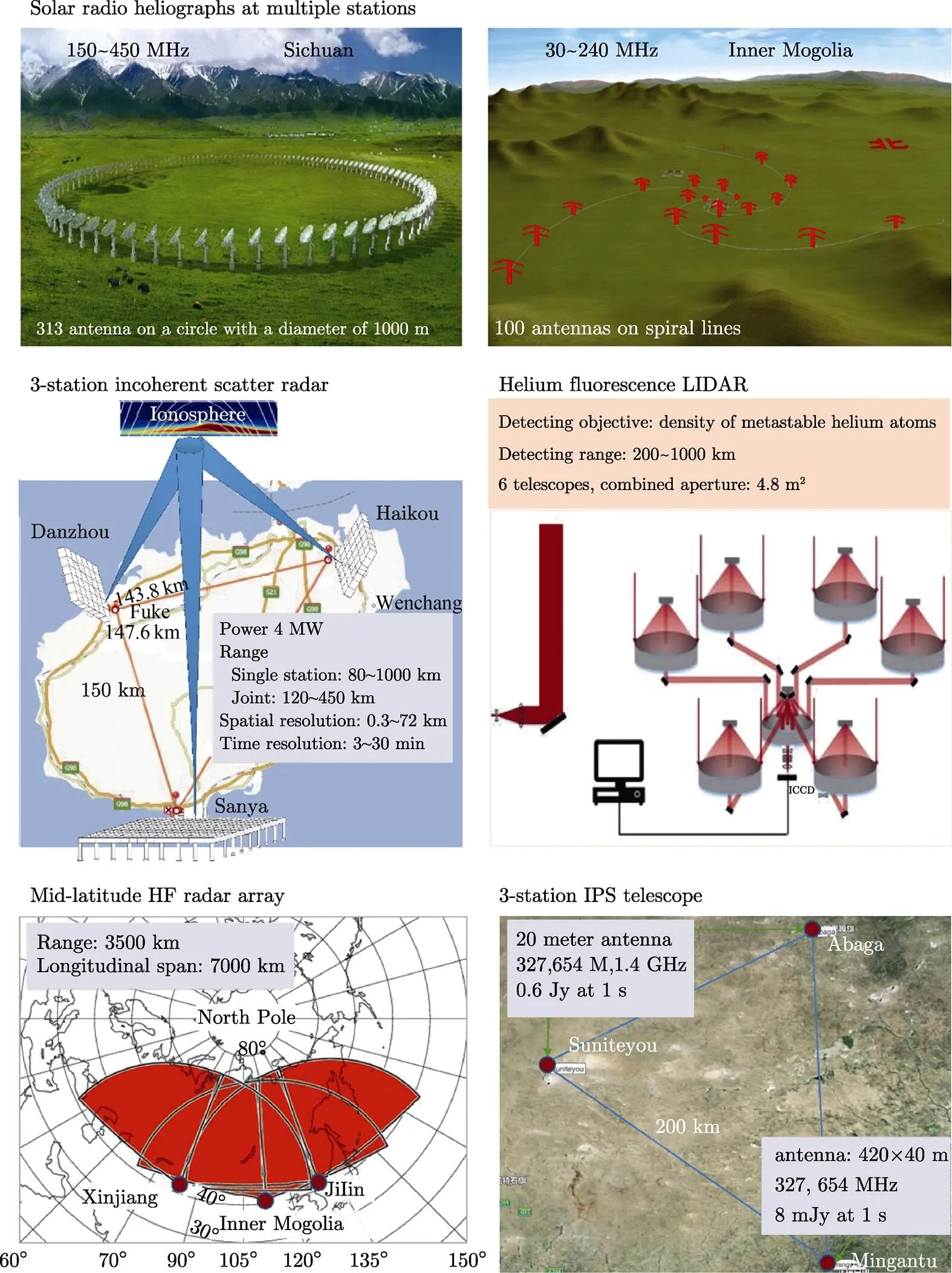
Fig.1 Some innovative instruments of the Phase II of the Chinese Meridian Project
5 Data Storage and Processing
Aside from the Space Environment Monitoring System comprised of the nearly 300 instruments, the project also has a Data & Communication System and a Science Application System. These two additional systems will be constructed anew rather than a minor upgrade to the existing systems in Phase I, since the estimated data volume is astonishingly huge compared to that of Phase I, and much more research and data applications will be developed.
It is estimated that the Data and Communication System has to cope with an annual data volume of about 2 PBs (petabytes). The data center will have 10 PBs storage capacity upon acceptance, with an expansion capacity of up to 30 PBs. To facilitate data transfer, based on the internet, VPN links connecting the data center and instruments will be established. Thus, most kinds of data will be collected in real-time and made publica website within 15 minutes.
The Science Application System will construct facilities and software for observation coordination, data analysis, modeling and simulation, space weather forecasting methods development, and international collaboration.
At the same time, mainly for accommodating these two systems, a 6-floor-building will be erected on the Huairou campus of NSSC in Beijing. It will serve as the headquarter of the Chinese Meridian Project.
6 Construction Plan and Current Status
Starting from 2015, the study team with members from more than 10 research institutes and universities has been working hard on the framework and detailed design of the Phase II of the project forward. In 2018, China’s National Development and Reform Commission approved the proposal of the project, to be followed by an approval for the Feasibility Study report in February 2019.
Construction of the project officially kicked off in November 2019. It is expected to finish by 2023. Now, the whole project is going through a detailed design stage. Due to the diversity of complexity, instruments are scheduled to finish construction on different dates. Standard instruments are hopeful to be ready by the end of 2021. From then on, these instruments will be put into operation.
7 Outlook and Concluding Remarks
Based on the Chinese Meridian Project, China is pushing forward an international collaboration initiative to carry out observation along the unique meridian circle of 120°E/60°W, which is called International Meridian Circle Program (IMCP). The proposal has been raising huge interests around the world. The proposal to initiate this international collaboration has been submitted to the Ministry of Science and Technology of China at the end of 2019.
The Chinese Meridian Project, including the already running Phase I and the Phase II under construction, will endow China and the world with solid ground-based capabilities to monitor space environment. After combined with the IMCP, an unprecedentedly comprehensive data set will be available for the whole science community, which is very much worthy looking forward to, and please stay tuned.
[1] Wang Chi. New chains of space weather monitoring stations in China [J]., 2010, 8, S08001. DOI: 10.1029/2010SW000603
[2] WANG Chi, XU Jiyao. Preliminary design report for Space Environment Ground-based Comprehensive Monitoring Network [R]. Beijing: Chinese Academy of Sciences, 2018
[3] WANG Chi. Recent advances in observation and research of the Chinese Meridian Project [J].., 2018, 38(5):640-649
P4
WANG Chi, Chen Zhiqing, XU Jiyao. Introduction to Chinese Meridian Project - Phase II., 2020, 40(5): 718–722. DOI:10.11728/cjss2020.05.718
* Supported by the Chinese Meridian Project
March 16, 2020
E-mail: cw@spaceweather.ac.cn
- 空间科学学报的其它文章
- SJ-10 Recoverable Satellite for Space Microgravity Experiments*
- Taiji-1 Satellite Mission*
- Progress Report on Insight-HXMT: China’s First X-ray Astronomy Satellite
- Progress of the Quantum Experiment Science Satellite (QUESS) Micius Project
- Space Solar Physics in China*
- Current Status and Main Scientific Results of In-flight CSES Mission*