
Update on Fengyun Meteorological Satellite Program and Development*
2020-04-16 13:55ZHANGPengCHENLinXIANDiXUZheGUANMin
空间科学学报 2020年5期
ZHANG Peng CHEN Lin XIAN Di XU Zhe GUAN Min
Update on Fengyun Meteorological Satellite Program and Development*
ZHANG Peng CHEN Lin XIAN Di XU Zhe GUAN Min
(100081)
China began to develop its meteorological satellite program since 1969. With 50-years’ growing, there are 17 Fengyun (FY) meteorological satellites launched successfully. At present, seven of them are in orbit to provide the operational service, including three polar orbiting meteorological satellites and four geostationary meteorological satellites. Since last COSPAR report, no new Fengyun satellite has been launched. The information of the on-orbit FY-2 series, FY-3 series, and FY-4 series has been updated. FY-3D and FY-2H satellites accomplished the commission test and transitioned into operation in 2018. FY-2E satellite completed its service to decommission in 2019. The web-based users and Direct Broadcasting (DB) users keep growing worldwide to require the Fengyun satellite data and products. A new Mobile Application Service has been launched to Fengyun users based on the cloud technology in 2018. In this report, the international and regional co-operations to facilitate the Fengyun user community have been addressed especially. To strengthen the data service in the Belt and Road countries, the Emergency Support Mechanism of Fengyun satellite (FY_ESM) has been established since 2018. Meanwhile, a Recalibrating 30-years’ archived Fengyun satellite data project has been founded since 2018. This project targets to generate the Fundamental Climate Data Record (FCDR) as a space agency response to the Global Climate Observation System (GCOS). At last, the future Fengyun program up to 2025 has been introduced as well.
Fengyun meteorological satellite, Product and data service, International co-operation and supporting, Historical Chinese Fengyun satellite data recalibrating, Future program
1 Introduction
The CMA Fengyun (FY) Meteorological Satellite Program includes both geostationary and polar orbit satellite missions. Fengyun satellites take place in series. The odd number series is the polar-orbiting series, while the even number series is the geostationary. The capital letter in the serial number refers to the seat of a particular satellite in the launching sequence.
Currently, 7 Fengyun satellites are running operationally in space, including 3 polar orbit and 4 geostationary satellites. Figure1 shows the present operational Fengyun satellite flying in space. In the past two years, no new Fengyun meteorological satellite has been launched. FY-2E was decommissioned on 11 January 2019, while FY-2H took its position on 1 January 2019[1,2].
In this report, the status of current polar orbiting, or Low Earth Observation (LEO), and Geostationary (GEO) meteorological satellites are updated in Chapter 2 and Chapter 3. The data service is introduced in Chapter 4. Especially, two useful mobile applications on WeChat platform are released to public to strengthen the data service of Fengyun satellites in 2018. With the continuous development of Fengyun satellite, there are increasing international users. Chapter 5 introduces the progress of international and regional cooperation, especially the Emergency Support Mechanism of Fengyun Satellite (FY_ESM) and its application in the Belt and Road countries. In Chapter 6, some recent progress of retrospective calibration of historical Chinese Fengyun satellite data is introduced. Finally, in Chapter 7, we look forward to the future planning of Fengyun satellite[3,4].
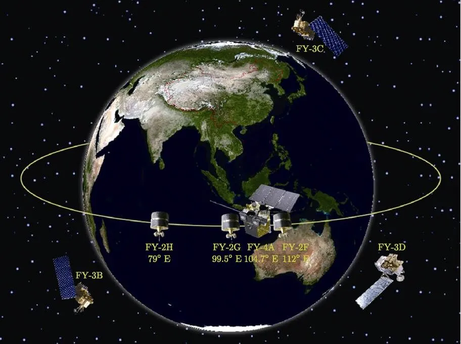
Fig.1 Operational Fengyun satellites in space
2 Status of Current LEO
The current operating LEO satellite system of CMA is the FY-3 series satellites flying on AM and PM orbits. Most of the sensors on-board satellites work well. Considered FY-3B on orbit for almost 10 years, there are some instruments out of work due to aging. Some instruments on-board FY-3C have been forced to shut down for the energy failure on the satellite platform. Some updated information of FY-3 is listed in the Table 1.
The FY-3 polar-orbiting satellite series is developed for LEO service from 2008 to 2025 beyond. Basically, the FY-3 series are capable of global atmospheric sounding, IR/VIS/Microwave imaging, radiation budget measurement and atmospheric composition measurement, including O3amount, CO2amount,. The capability of precipitation sounding with radar has been developed for the coming rainfall mission in 2022.
The detailed descriptions for main instruments are as follows.
VIRR (Visible and Infra-Red Radiometer), flying on FY-3A/B/C, 10-channel VIS/IR radiometer for multi-purpose imagery, resolution 1.1 km, swath 2800 km.
MERSI (Medium Resolution Spectral Imager), flying on FY-3A/B/C, 20-channel radiometer (19 in VIS/NIR/SWIR and one in TIR at 10.0~12.5 μm) for ocean color and vegetation indexes. Resolution 250 m for 4 VIS/NIR and one TIR channel, 1 km for other channels; swath 2800 km. Since FY-3D, the MERSI is evolved to MERSI-2, which has 25 channels (19 in VIS/NIR/SWIR and 6 in TIR from 3.7~ 12.5 μm).
MWRI (Micro-Wave Radiation Imager), flying on FY-3A/B/C/D, 5-frequencies/10 channels (all frequencies in double polarization) for multi-purpose MW imagery. Conical-scanning radiometer, resolution 9.5 km×15 km at 90 GHz, 30 km×50 km at 19 GHz, swath 1400 km.
IRAS(Infra-Red Atmospheric Sounder), flying on FY-3A/B/C, 26-channel IR radiometer (including one VIS) for temperature/humidity sounding, resolution 17 km, swathe 2250 km.
MWTS (Micro-Wave Temperature Sounder), flying on FY-3A/B, 4-channel MW radiometer for nearly-all-weather temperature sounding, 54 GHz band, resolution 70 km, cross-track scanning, swath 2200 km.
MWTS-2 (Micro-Wave Temperature Sounder), flying on FY-3C/D, 13-channel MW radiometer for nearly-all-weather temperature sounding, 54 GHz band, resolution 70 km, cross-track scanning, swath 2200 km.
MWHS (Micro-Wave Humidity Sounder), flying on FY-3A/B, 4-frequency/5-channel (one frequency in double polarization) MW radiometer for nearly- all-weather humidity sounding. 183 GHz band, resolution 15 km, cross-track scanning, swath 2700 km.
MWHS-2 (Micro-Wave Humidity Sounder), flying on FY-3C/D, 15-channel MW radiometer for nearly-all-weather humidity sounding. 183 GHz band, resolution 15 km, cross-track scanning, swath 2700 km.
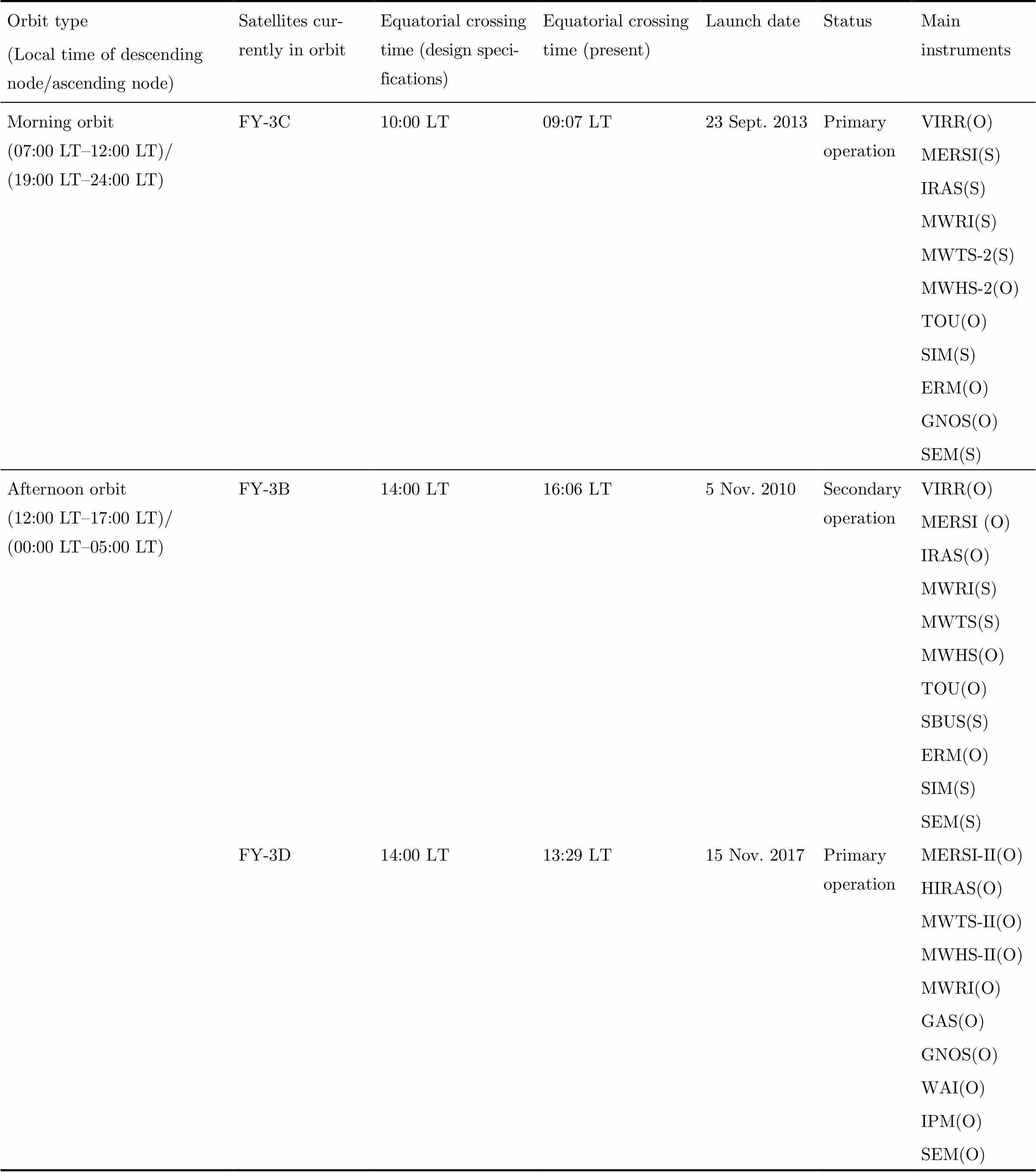
Table 1 Current Fengyun polar-orbiting satellites (as of 1 March 2020)
Note (O) means the instruments working operationally, (S) means the instruments are shutdown.
TOU/SBUS (Total Ozone Unit and Solar Backscatter Ultraviolet Sounder), flying on FY-3A/ B/C, a suite of two UV spectro-radiometers, one (TOU) with 6 channels in the 308~360 nm range, resolution 50 km, swath 3000 km, for total ozone; the other one (SBUS) with 12 channels in the range 252~340 nm, resolution 200 km, nadir viewing, for ozone profile.
ERM (Earth Radiation Measurement), flying on FY-3A/B/C, 2 broad-band channels radiometer for Earth reflected solar flux and Earth emitted thermal flux over total (0.2~50 μm) and short (0.2~4.3 μm) waveband; resolution 28 km, cross-track scanning with 2° NFOV, swath 2300 km, nadir viewing with 120° WFOV.
SIM (Solar Irradiance Monitor), flying on FY-3A/B/C, 3-channel radiometer over 0.2~50 μm waveband for the total incident solar flux; viewing the Sun near the north pole area.
GNOS(GNSS Occultation Sounder), flying on FY-3C/D, receives the signal from GPS or China Beidou satellites; observing over 1000 occultation events per day.
GAS(Greenhouse gases Absorption Spectrometer), flying on FY-3D, has four narrow bands with center wavelength located at 0.76 μm, 1.6 μm, 2.1 μm and 2.3 μm, which observes infrared light reflected from the Earth’s surface and the atmosphere. Column abundances of CO2and CH4are calculated from the observational data.
SEM (Space Environment Monitor), flying on FY-3A/B/C/D, for in-situ observation of charged particles in the proximity of satellite.
WAI(Wide-field Auroral Imager), flying on FY-3D,for remote sensing imaging the N2Lyman- Birge-Hopfield (LBH) auroral bands.
IPM(Ionospheric PhotoMeter), flying on FY-3D, for nadir remote sensing the airglow intensity of the OI 135.6 nm and N2Lyman-Birge-Hopfield (LBH) bands.
3 Status of Current GEO
The primary operational observation position of FY-2 satellites is 105°E, the secondary position is 86.5°E. The current FY-2 constellation consists of 5 satellites, namely FY-2H/G/F/E/D. FY-2D was retired and stand by at 123.5°E. FY-2H was the latest one, which is positioned at 79° especially for Indian ocean observation.
The second generation of GEO satellite of CMA is FY-4 series. Unlike FY-2, FY-4 is three-axis stabilized; and apart from inherited and much enhanced capability in imaging, it’s also designed to have sounding, lightning mapping, and space weather monitoring capabilities. On 11 December 2016, the first FY-4 model FY-4A was launched from the Xichang satellite launch center. It was positioned at 99.5°E for in-orbit check out and moved to 104.7°E for primary operation. The first imagery obtained by ground station was released 27 February 2017, implying that both space and ground segments are functioning well[5, 6].
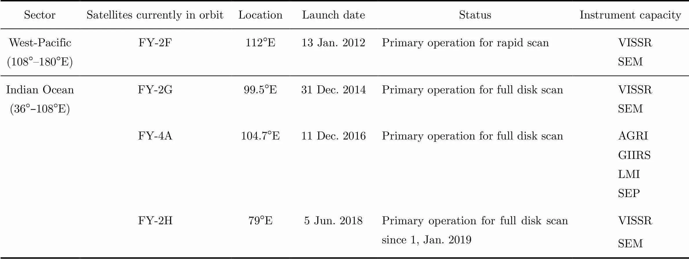
Table 2 Current Fengyun geostationary satellites (as of 1 March 2020)
3.1 FY-2 Program
The primary objectives of FY-2 program are as follows: (i) continuously observing to obtain the Earth imagery in visible, infrared, and water vapor spectral bands, from which sea surface temperature, cloud parameters, and wind vectors can be derived; (ii) operating the Data Collection System (DCS) to collect and transmit data from domestic and overseas data collection platforms (DCPs); (iii) broadcasting data in HRIT/LRIT format, and (iv) Monitoring space environment.
There are two main payloads carried on FY-2. The detailed descriptions for each payload are as follows.
VISSR (Visible and Infrared Spin Scan Radiometer): The version for FY-2A/B had three VIS/IR channels (05~1.05 μm, 6.3~7.6 μm, and 10.5~12.5 μm), the improved version for FY-2C/D/E/F/G/H splits the IR channels into two and adds a 3.5~4.0 μm channels. The resolution is slightly improved from 5.76 km (IR) and 1.44 km (VIS), to 5.0 km (IR) and 1.25 (VIS). The image cycle is 30 min.
SEM (Space Environment Monitor): A space particle monitor and an X-ray monitor are mounted on FY-2 to detect the space environment in proximity of the satellite, the solar activities, and relevant space phenomena. The SEM is transmittedtelemetry to the ground system.
Data Collection System of FY-2 has two uplink bands, whose frequencies are 402.0 ~ 402.1 MHz for international DCPs (33 channels of bandwidth 3 kHz, bit rate 100 bit·s–1, modulation BPSK/PCM) and frequencies 401.1 ~ 401.4 MHz for domestic DCPs (400 channels of 750 Hz spacing, bit rate 600 bit·s–1, modulation QBSK), with right-hand circular polarization.
由式(12)可知,交点轴线T-Map是4维E4中两个相交曲面约束的凸体,不能直接用于3维空间坐标的控制与检测,需将4维空间域投影到2、3维空间,将交点轴线偏差波动直接转换为映射点的坐标误差。
3.2 FY-4 Program
FY-4 program is the successor of FY-2 program. The primary objectives of FY-4 program are as follows: (i) to take multiple spectral channel imagery of the Earth with high temporal resolution; (ii) to measure atmospheric vertical profile of temperature and humidity with improved vertical resolution and detection accuracy; (iii) to detect and map positions of lightning events; (iv) to monitor solar activities and space environments for space weather forecast service; (v) to collect data from data platforms and transmit to users; (vi) to broadcast observational images, data, and derived products with aboard transponder.
There are four main payloads carried on FY-4. The detailed descriptions for each payload are as follows.
AGRI (Advanced Geosynchronous Radiation Imager): to fly on FY-4A/B/C, multispectral imager with two independent mirrors scanning north-south and east-west directions respectively; 216 sensors in 14 bands from visible to long-wave infrared (0.55~ 13.8 μm); on-board calibration for all bands, full optic length of radiation considered in calibration; resolutions: 1 channel in 500 m, 2 channels in 1 km, 4 channels in 2 km, 7 channels in 4 km;/90~200, NE Δ0.2~0.7 K at 300 K; full-disk scanning time <15 min.
GIIRS (Geo. Interferometric Infrared Sounder): to fly on FY-4A/B/C, two independent mirrors scanning north-south and east-west directions respectively; 32×4 plane arrays for mid-wave (375 S/MIR channels) and long-wave infrared bands (538 LWIR channels); resolution 16 km; active and radiant coolers; radiometric calibration accuracy 1 K; spectral calibration accuracy 10 ppm; Mesoscale 35 min (1000 km×1000 km), China area 67 min (5000 km×5000 km).
LMI (Lightning Mapping Imager): to fly on FY-4A/B/C, two tubes for observation to achieve more spatial coverage; central frequency: 777.4 nm;/≥6; spatial resolution: 7.8 km temporal resolution 2 ms.
SEP (Space Environment Package): to fly on FY-4A/B/C, a suite that contains a Magnetometer for magnetic field vector, an Energetic Particle Detector detecting high-energy electron storms (1~165 MeV, and >165 MeV) and proton events (0.4~4 MeV), and Space Weather Effect Detectors for the impact of space weather on the spacecraft.
DCS of FY-4 has two uplink bands, with frequencies from 402.0 to 402.1 MHz for international DCPs (33 channels of 3 kHz bandwidth, bit rate 100 bit·s–1, modulation BPSK/PCM) and frequencies 401.1~401.4 MHz for domestic DCPs (400 channels of 750 Hz spacing, bit rate 600 bit·s–1, modulation QBSK), and right-hand circular polarized
4 Product and Data Service
4.1 Archive Data Service
NSMC preserves data to the domestic and international user communities since 1983. The daily archive data volume is increasing rapidly at 0.5 GByte in 1987 and 8000 GByte in 2019. By the end of 2019, NSMC has stored data volume up to 15 PB from 25 satellites. Fengyun series meteorological satellites data catalog statistics which are shared by the global community shown in the table3.
NSMC Data Center is responsible for Fengyun series satellite and the third party satellite data management and long term preservation, allows data download and assists domestic and international users with as much convenience as possible in their search for meteorological and environmental satellite products.
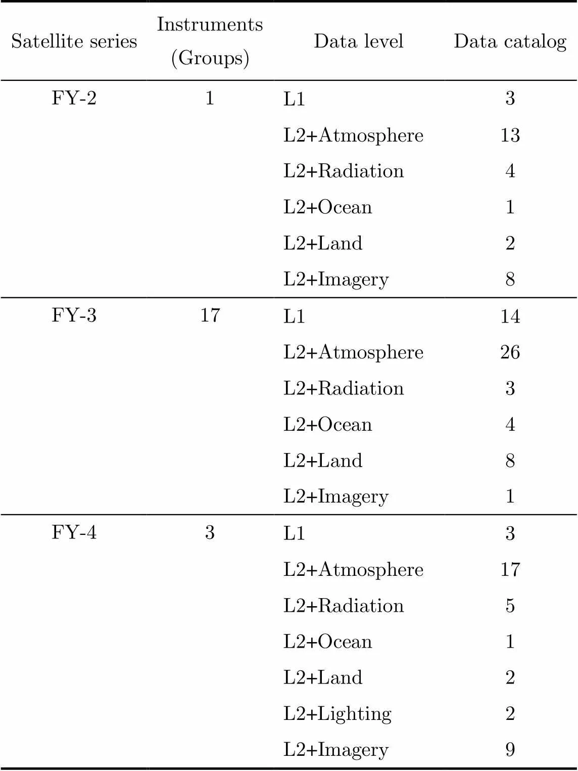
Table 3 Fengyun satellite data catalog statistic
The full Fengyun satellite archive dataset will be available on NSMC satellite data service website in English version (http://data.nsmc.org.cn). Users can search and download Fengyun satellite data after registration.
Over the past 12 years, more than 80 thousands users registered on the Fengyun satellite data service website by the end of 2019. More than 5.4 PB satellites’ data have been delivered to domestic and international users in 2019.
4.2 Rear Time Data Service
NSMC/CMA distributes real-time Fengyun meteorological satellite data for the high timeliness requirement users through Fengyun satellite direct broadcast and CMACast. Users in Fengyun satellites direct broadcast service area with appropriate receiving equipment can directly receive real-time data.
FY-2 DB: Stretched VISSR (S-VISSR) Data Transmission, compatible with MDUS acquisition stations. Main features: frequency 1687.5 MHz; bandwidth 2.0 MHz; polarization linear; antenna diameter about 3 m,/about 12 dB·K–1, data rate 660 kbit·s–1.
FY-4 DB: FY-4 provides 1675~1687 MHz HRIT (High Rate Image Transmission), 1696~1698 MHz LRIT (Low Rate Image Transmission).
FY-3 DB: MPT (Medium-resolution Picture Transmission), for full information transmission of MERSI measurement on FY-3A/B/C. Main features: frequency: 7775 MHz; bandwidth: 45 MHz; polarization: right-hand circular; antenna diameter about 3 m,/about 21.48 dB·K–1, data rate 18.7 Mbit·s–1; AHRPT (Advanced High Resolution Picture Transmission) for full information transmission of the instruments exclusive of the MERSI on FY-3A/B/C. Main features: frequency: in the range of 1704.5 MHz; bandwidth: 6.8 MHz; polarization: right -hand circular; Antenna diameter about 3 m,/about 6.8 dB·K–1, data rate: 4.2 Mbit·s–1.
To support DB users to receive and process FY-3 transmission data, NSMC/CMA provides the Satellite to Ground Interface Control Document, pre-processing software packages for 5 instruments, namely MERSI, VIRR, MWTS, MWHS, and MWRI on http://satellite.nsmc.org.cn. Processing software for GNOS is also provided since FY-3D.
The CMACast users can receive Fengyun satellite data and product with DVB-S equipment in near real-time. There are 2525 deployed CMACast receiving terminals, in which 22 overseas. Additional information of CMACast can be found on CMA WIS Portal (http://gisc.wis.cma.cn/wis/portal.pub).
4.3 Mobile Application Service Launched in 2018
To increase the impact of Fengyun series satellites and help users obtain Fengyun satellite imagery, NSMC has launched 2 mobile applications on WeChat platform in 2018,., FY Earth View for LEO satellites and FY Live for GEO satellites.
WeChat is one of the most popular instant messaging services in China and some overseas countries. By the end of 2019, WeChat had over 1.15 billion monthly active users from a wide range of age groups worldwide. WeChat Applet (mini-App, little program) is a special framework designed by Tencent that provides a light solution for using mobile application within the WeChat eco-system. It allows users to launch new Apps without download.
Fengyun Earth View WeChat Applet releases the latest 7 days global true color Earth image captured by the MERSI-II instrument onboard FY-3D. The functions include: (i) dragging and zooming in/out to view the full resolution global image; (ii) switching to the previous or next date; (iii) choosing interface between 3D mode and 2D mode; (iv) showing the location of current user.
Fengyun Live WeChat Applet shows the time-series live cloud images taken by AGRI onboard FY-4A. Its functions include: (i) the most recent image of China region and full disk; (ii) the videos of different regions in the latest 3/6/12/24/48/72 hours. This WeChat Applet can provide a convenient way for users to have a timely view of the live cloud imagery of FY-4A byusing mobile phones.By the end of 2019, Fengyun Live has accumulated 95375 users. Its daily active user count reached its peak at nearly four thousand on 10 August, as typhoon LEKIMA (201909) was approaching eastern China.
The interfaces of Fengyun Earth View and Fengyun Live are shown in Figure 2.
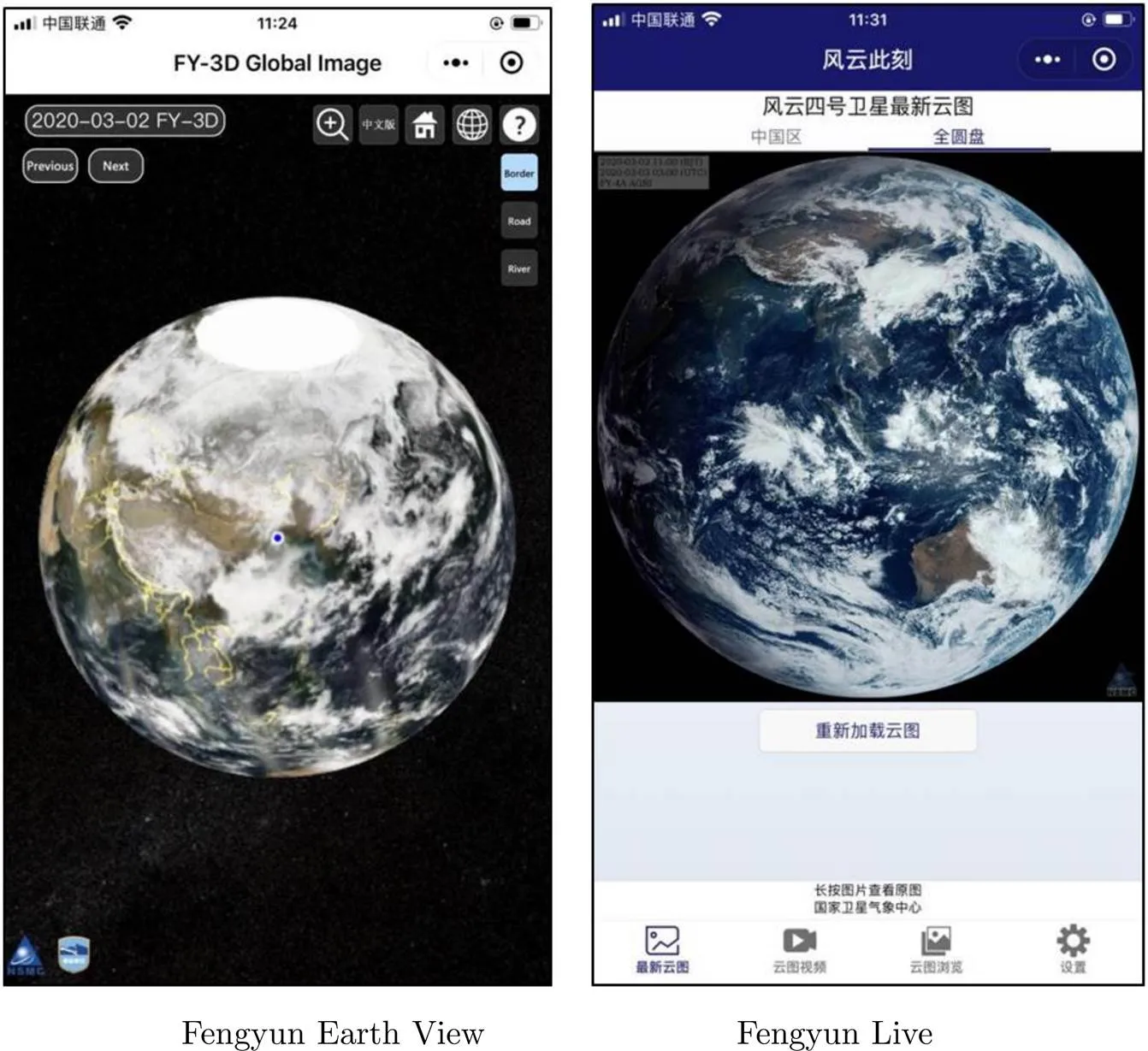
Fig.2 Interface of Fengyun Earth View and Fengyun Live
5 International Co-operation and Supporting
5.1 International and Regional Co-operations
With the capability of multi-spectral global monitoring, and timeliness full disk quick observation, Fengyun satellites were ready to serve global users, especially to Belt and Road. Figure 3 illustrates Fengyun user distribution map on Belt and Road region. By the year of 2019, many countries along Belt and Road received Fengyun satellite data by various means. Real-time data users established different kinds of satellite data direct broadcasting systems, including 19 CMACast stations, 6 FY-2 DB stations, and 2 FY-3 DB stations. FY-3 preprocessing software packages have been freely shared and installed in 25 countries. 27 countries registered as members of FY_ESM. The Fengyun satellite data center website users have expended to 106 counties. Fengyun satellites have been incorporated into the global operational application meteorological satellite series by the World Meteorological Organization (WMO). NSMC is also cooperating with EUMETSAT, NOAA, CGMS, CEOS, CSPP, and other foreign satellite agencies and organizations. Besides, CMA strengthened cooperation with regional and Belt and Road countries by enhance Fengyun satellites service capabilities. CMA signed an agreement with the National Institute of Meteorology of Mozambique (INAM), the Ministry of Emergency Situations of the Kyrgyz Republic (MES KR), and the Civil Aviation of the Sultanate of Oman represented by the Directorate General of Meteorology (DGMet) in 2019. Those agreements aimed to improve the application of Fengyun meteorological satellite data and enhance the capacity in weather forecasting, disaster warning, and disaster prevention and mitigation service, which are of great significance to protecting the safety and well-being of the peoples of the two countries and the national economic development as well as to promoting regional cooperation.
5.2 Disaster Support
In April 2018, the China Meteorological Administration (CMA), the China National Space Administration (CNSA), and Asia-Pacific Cooperation Organization (APSCO) jointly signed the Letter of Intention for Cooperation in the Application of Fengyun meteorological satellite. This will improve international cooperation related with Fengyun satellite. At the same time, CMA introduced the Emergency Support Mechanism of Fengyun satellite (FY_ESM), open to international users who made a request once visited by such extreme events as typhoon, heavy rain, severe convection, forest or grassland fire, and sand storm. By 2019, twenty-eight countries registered as a member of FY_ESM. According to FY_ESM user’s requirements, CMA initiated several times of FY_ESM, provided FY-2, FY-3, and FY-4 data, products and application tools, supported disaster prevention and mitigation in those countries. Besides, Fengyun satellites were important members of the Global Earth Observation (GEO), as well as the duty satellite of International Charter Mechanism for Disaster Reduction (CHARTER), CDDR mechanism (China GEOSS Disaster Data Response), and United Nations Platform for Space- Based Information for Disaster Management and Emergency Response (UN-SPIDER). Table 4 lists the Fengyun satellite disaster support cases between 2018 and 2019.
5.3 Belt and Road Supporting Action and Plan
To support Belt and Road countries, a series of action plans in three parts have been put on the agenda. Some actions have been implemented by NSMC and related organizations in CMA.
The first part of this plan is to enhance data receiving capabilities on Belt and Road. CMA is planning to help regional countries receiving Fengyun satellite data by building or updating Direct Broadcasting system (DB), CMA Data Broadcasting System (CMACast), cloud services, and other means. In December 2019, Mozambique has built a FY-2H DB antenna and operationally received images. More DB antennas planned to build in other 8 counties were decided and supported by CMA and APSCO. More than thirty countries were downloading Fengyun dataNSMC FTP server. Forty-four users from twenty-five countries installed FY-3 pre-processing software packages which can help those users generate level 1 data from level 0 which they received from MERSI, VIRR, MWRI, MWTS, MWHS and IRAS on FY-3 satellites by their own antennas.
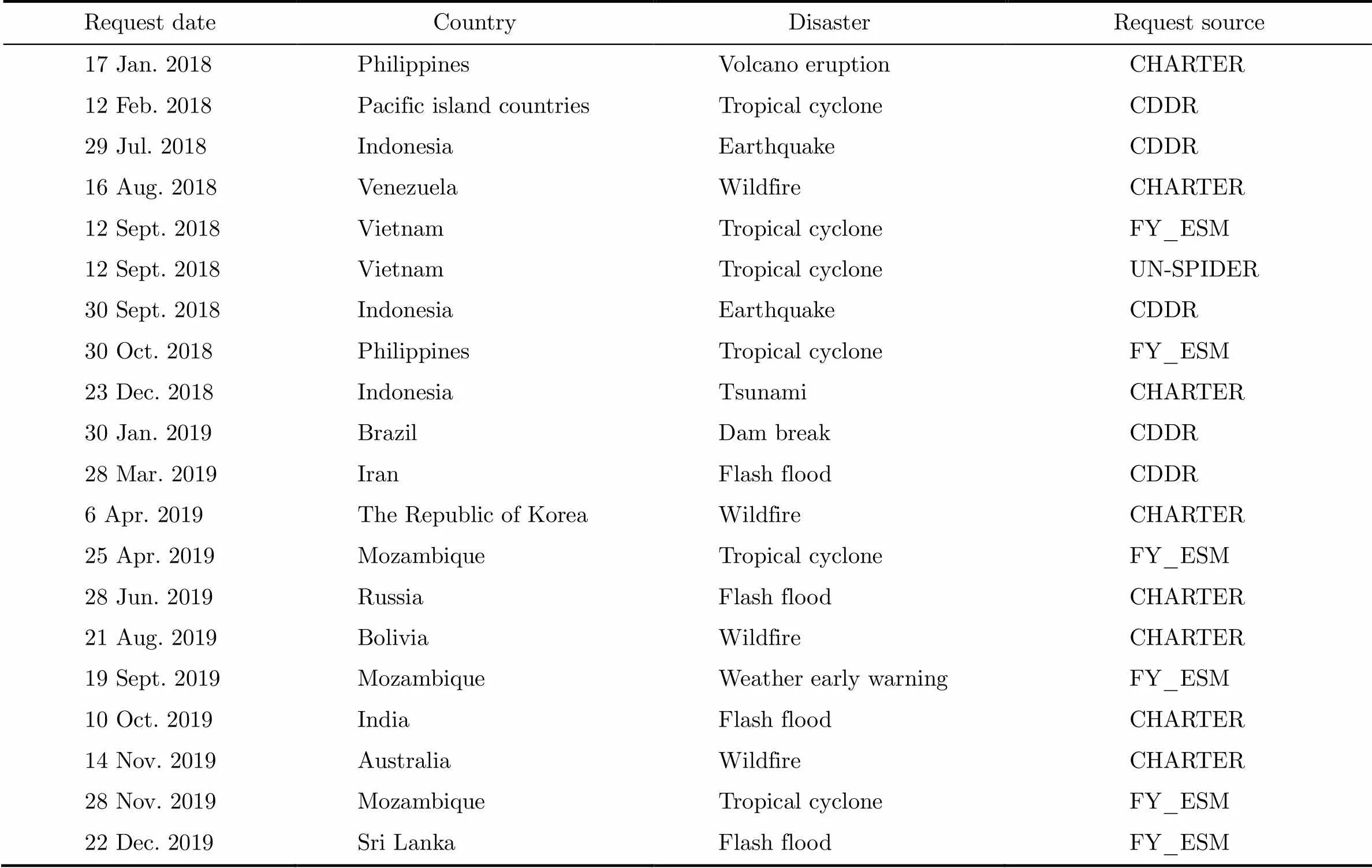
Table 4 List of Fengyun satellite disaster support cases between 2018 and 2019
The second part is to enhance user’s capability of applications by using Fengyun satellite data. NSMC developed two application tools which can help users to process Fengyun satellite data in their work. Satellite Weather Application Platform 2.0 (SWAP 2.0) focused on weather analysis, and weather forecast which mainly adopted GEO Fengyun satellites. SWAP 2.0 has two versions, web- based version, and stand-alone version. Web-based SWAP 2.0 (http://rsapp.nsmc.org.cn) displays FY-2H, FY-4A full disk and regional images, 28 products, and multi-language supported, such as English, Russia, and Chinese. Satellite Monitoring and Remote-sensing Toolkit (SMART 2.0) focused on environment and biological monitoring on land surface, ocean surface, water body, and ice surface based on medium and high-resolution Earth observation satellites, including FY-3, GAOFEN, NOAA and so on. Besides those application tools, NSMC planned to generate customized products according to international users’ requirements.
The last part is to strengthen international scientific exchange and communications with Belt and Road countries, including holding international user conference and training courses, financing scientist exchange, and organizing training materials. NSMC planned to hold an international user conference every two years from 2019. The First Fengyun satellite international user conference took place on 15–17 November 2019 in Haikou, Hainan province, China[7]. Experts from over 30 countries and regions, WMO, APSCO, NOAA, EUMETSAT, and the Sixth International Strategic Consultative Committee on Chinese Meteorological Satellite Programs (ISCC) attended this conference. In 2019, CMA held two international training courses on Fengyun satellite applications. CMA delegations visited Thailand, Kyrgyzstan, Kazakhstan, and other five countries on Fengyun satellite cooperation and held on-site training and facility maintenance during the visit.
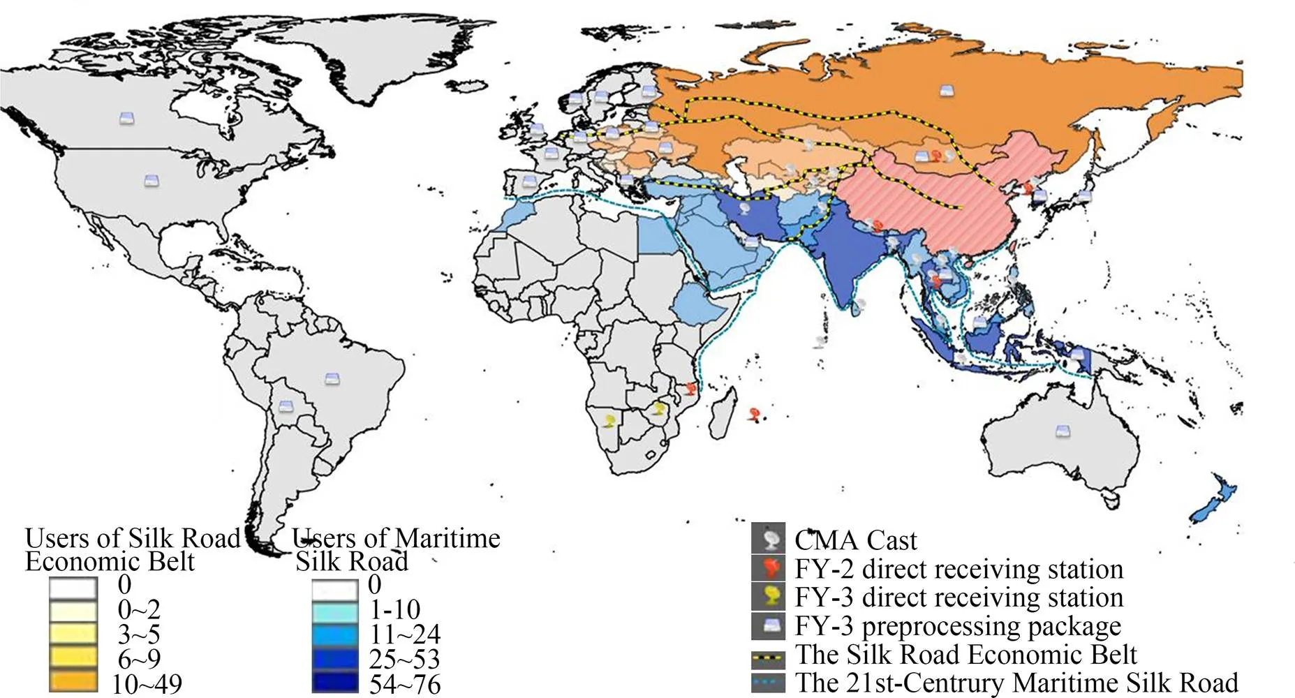
Fig.3 Fengyun user distribution map in Belt and Road region
The Belt and Road supporting project on Fengyun satellite will last until 2023. NSMC will make a special effort on this project, improve remote sensing application level of international users, and strengthenFengyun satellite socio-economic benefits for those countries.
6 Progress of Retrospective Calibration of Historical Chinese Fengyun Satellite Data
The first Chinese meteorological satellite was launched in 1988. So far, the Chinese meteorological satellites have been continuously observing for nearly 30 years. Satellite replacement and on-board sensors upgrade make the old and new observation data non-harmonized in terms of accuracy, stability, and consistency, which cannot meet the basic needs of long-term sequence climate and environmental change research.
To enhance the capability on the space-based Essential Climate Variable (ECV), a new National Key Research & Development Program of China was funded since 2018 to re-calibrate the historical Chinese Earth Observation satellite data including the Chinese Fengyun meteorological satellites, the Chinese Haiyang Oceanic Satellites (HY), and the Chinese Ziyuan Resource Satellites (ZY).
The historical Chinese Fengyun satellites include thirteen meteorological satellites (FY-1A, FY-1B, FY-1C, FY-1D, FY-2A, FY-2B, FY-2C, FY-2D, FY-2E, FY-2G, FY-3A, FY-3B, and FY-3C) and seven types of on-boarded instruments (VIRR, VISSR, MERSI, IRAS, MWTS, MWHS, and MWRI). The vicarious China Radiance Calibration Site (CRCS) calibration, the Pseudo-Invariant Calibration Sites (PICS) calibration, the Deep Convective Clouds (DCC) calibration, and the lunar calibration have been considered in the procedure of the re-calibration for solar reflectance bands. New on- board calibrate models will be built for infrared and microwave bands re-calibration.
To construct Fundamental Climate Data Record (FCDR) of Fengyun meteorological satellites for FY-1/2/3 series optical and microwave remote sensing instruments, some of the key technologies need to break through, including the historical data backtrack and diagnosis, high-precision positioning with lack of attitude and orbit information. Key technologies such as radiometric information restoration and inter-generational satellite radiometric homogenization, and rapid processing of satellite big data are used to support platform for PB-level Fengyunhistorical data re-processing. Based on the common and individual requirements, four climate product data sets, including sea surface temperature, outgoing longwave radiation at the top of the atmosphere, surface temperature, and vegetation index, have been preliminarily established after repositioning and recalibration of the nearly 30 years’ historic data. A unified and standardized data set is expected to be released in 2021.
Mining the multi-source calibration information, establishing the historical radiometric benchmark for the optical instrument, constructing the accurate physical calibration model of the similar instruments, the radiometric response and attenuation behaviour model within the life cycle, and the inter-generational radiometric reference transfer model, which are the key technologies for long series of historical data of the optical instruments.
A long-range radiometric reference for microwave payloads is established, and the physical mechanism of radiometric response of the microwave radiometer calibration system is revealed, breaking through the key technologies of full-link radiometric transfer and characteristic evolution analysis during the lifetime and inter-generational period of the instruments. Reprocessing based on re-analyzed data verifies that the microwave historical data re-calibration model is constructed successfully.
Other key technologies include historical data backtracking and defect diagnosis, track information location and backtracking deficiency, and radiometric information recovery in a non-ideal calibration state. It is realized to transfer inter-generation satellite radiometric reference, and to construct a big data and rapid intensive processing platform for LEO and GEO Fengyun satellites. The primary climate data sets and more than three Thematic Climate Data Record (TCDR) data-sets for 30 years will be established and released. The research scheme is shown in Figure 4.
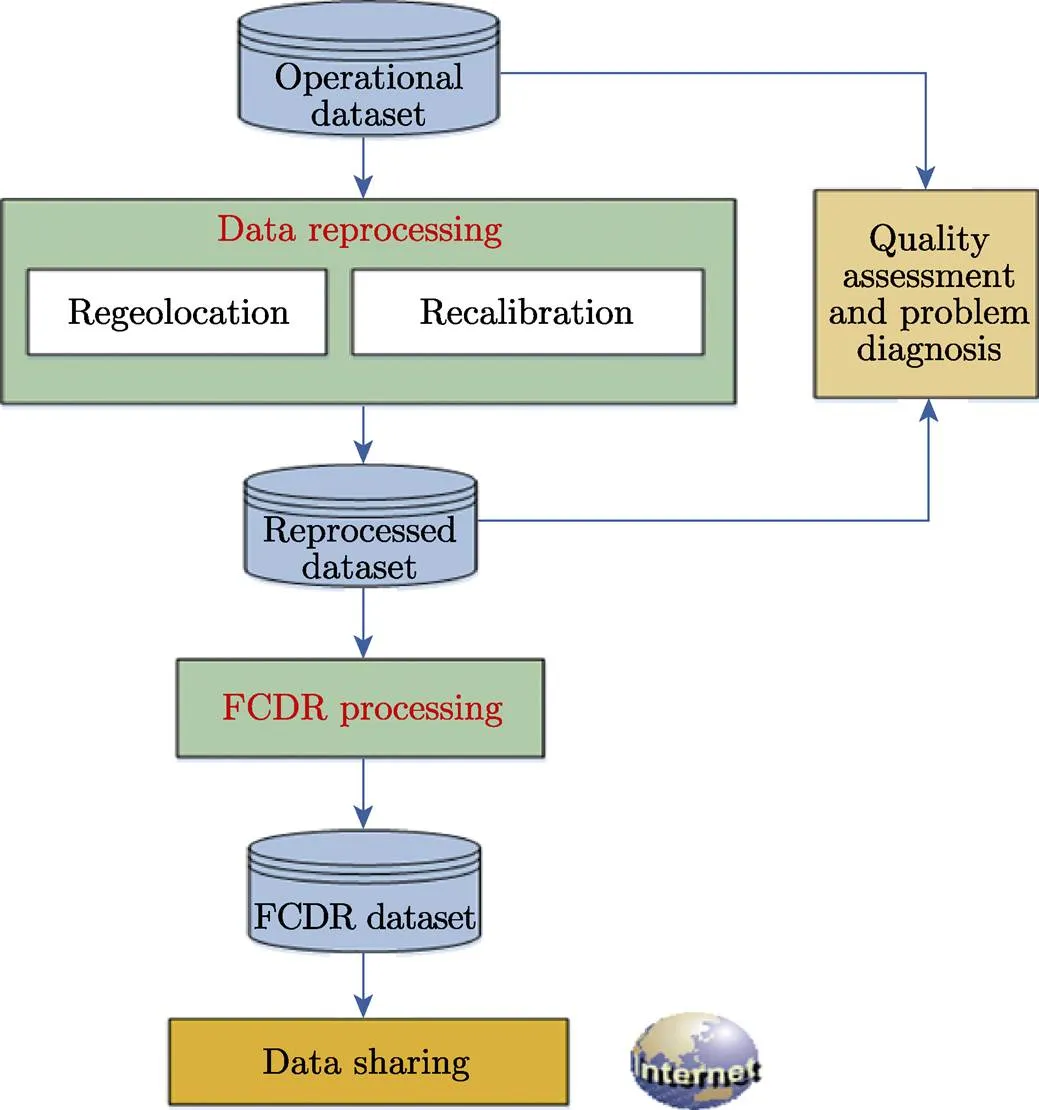
Fig.4 Research scheme for retrospective calibration of historical Chinese Fengyun satellite data
7 Future Program
According to the approved plan for China’s meteorological satellites and its application[8,9], by 2020, a stable operational system of FY-3 polar-orbiting meteorological satellites will be established, which can form a network observation capability of morning, afternoon and inclined orbit constellation. Meanwhile, the operational pattern of the FY-4 geostationary meteorological satellites “dual-satellite operation and in-orbit backup” will be established. Up to now, there are four FY-3 polar-orbiting satellites to be launched, which will be arranged by the layout of three solar synchronous polar-orbiting satellites in early-morning, mid-morning and afternoon, and one precipitation measurement satellite in an inclined orbit. There are two more FY-4 geostationary satellites to be launched.
7.1 Future FY-3 Polar-orbit Satellites
The third batch of FY-3 satellite program, which includes four satellites FY-3E/F/G/H, has been approved and scheduled to be launched in the next three years.
FY-3E, which is the first early-morning orbit satellite in China’s polar-orbiting meteorological satellite family, is scheduled to be launched in 2020. Its local time at descending node is 05:30. It is equipped with 11 advanced remote sensing instruments. There are the MERSI for low-light level, the HIRAS, the GNOS, the MWTS, the MWHS, the SIM, the Solar Spectral Irradiance Monitor (SSIM), the Wind Radar, the SEM, the Multi-angle Ionospheric Photometer (MIPM) and the Solar X-ray and Extreme Ultraviolet Imager (XEUVI). FY-3E will focus on the application of Numerical Weather Prediction (NWP), while ensuring the global imaging observation and atmospheric vertical sounding measurement.
FY-3F is a mid-morning orbit satellite with descending equatorial crossing time at 10:00 LT. It’s scheduled to be launched in 2022. There are 9 remote sensing instruments on it, which are MERSI, MWTS, MWHS, MWRI, GNOS, HIRAS, Ozone Measurement Suite (OMS), the ERM, and SIM. FY-3F will focus on the observation of the Earth’s surface imagery, which is mainly applied to weather forecasting, ecological environment monitoring, meteorological disaster monitoring, and research.
FY-3G, which is an inclined low Earth orbit satellite mainly used for precipitation measurement, is scheduled to be launched in 2022. There are 4 remote sensing instruments on it, which are MERSI (simplified type), MWRI (precipitation type), GNOS, and the Precipitation Measurement Radar (PMR). FY-3G is mainly used for monitoring heavy rainfall in severe weather system, providing three-dimensional structure information of precipitation in the middle and low latitudes of the world, and supporting for improving the accuracy of precipitation meteorological forecast.
FY-3H, which is the last one in the third batch of FY-3 satellite program, is an afternoon orbit satellite, scheduled to be launched in 2023. Its local time at ascending node is 14:00 LT. There are 9 remote sensing instruments on FY-3H, which are MERSI, MWTS, MWHS, MWRI, GNOS, HIRAS, GAS, WAI, and IPM. The main objectives of FY-3H are the quantitative detection of atmospheric composition and the monitoring of climate change. Its data can be used for weather forecasting, atmospheric chemistry, and climate change monitoring and research. Table 5 shows the information of the future FY-3 polar-orbiting satellites and their instruments.
The fully networked FY-3 operational satellites will have integrated observation capabilities, such as high temporal and spatial resolution global optical imaging observation capability, high precision optical and microwave combined atmospheric temperature and humidity vertical distribution detection capability, GHG measurement capability, wind field and precipitation measurement capabilities with active remote sensing instruments, and the solar and space environment monitoring capabilities.
7.2 Future FY-4 Geostationary Satellites
According to China’s meteorological satellite development plan, two operational meteorological satellites in geostationary orbit, named the FY-4B and FY-4C in the second batch of FY-4, will be launched around 2020 to ensure the continuity, reliability, and stability of the observation service of geostationary meteorological satellites.
FY-4B, which is the first operational geostationary satellite in FY-4 series, is scheduled to be launched in 2020. The main observation capabilities are similar to those of FY-4A, with some significant performance improvements. It will be probably positioned at a 105°E to continue operations as a main operational geostationary meteorological satellite. The remote sensing instruments on FY-4B are the AGRI, the GIIRS, the Geostationary Fast-scan Imager (GFI), and the SEP.
Compared with the previous two satellites FY-4A and FY-4B, the capability of FY-4C will reach and exceed the international advanced level. The space weather monitoring capability of FY-4C has been further enhanced with the addition of some space weather observation instruments. It is scheduled to be launched in 2022. The position will be determined according to the technical status and other factors at that time. The remote sensing instruments include AGRI, GIIRS, LMI, SEP, the Multiband Ionospheric Ultra-Violet Spectrum Imager(MUSI), the Solar Extreme-Ultraviolet Imager (SUVI), and the Solar X-EUV Irradiance Sensor (SXUS). The information of future FY-4 geostationary satellites and their instruments are showed in Table6.
Table 5 Future Fengyun polar-orbiting satellites
FY-4 series satellites represent an improved and new capability of the Chinese geostationary weather satellite system. With advanced imaging and sounding instruments on FY-4 series, providing high temporal, spatial, and spectral resolution measurements, the benefit is expected to be large for severe weather monitoring, warning, and forecasting. The lightning information is expected to significantly improve warnings of severe storm hazards, convection precipitation, and lightning strikes. Assimilation of data and derived products from the AGRI, GIIRS, and LMI in both global and regional NWP models are expected to show valuable improvement in forecast capabilities. FY-4 series will also enhance the capabilities of space weather monitoring and warning.
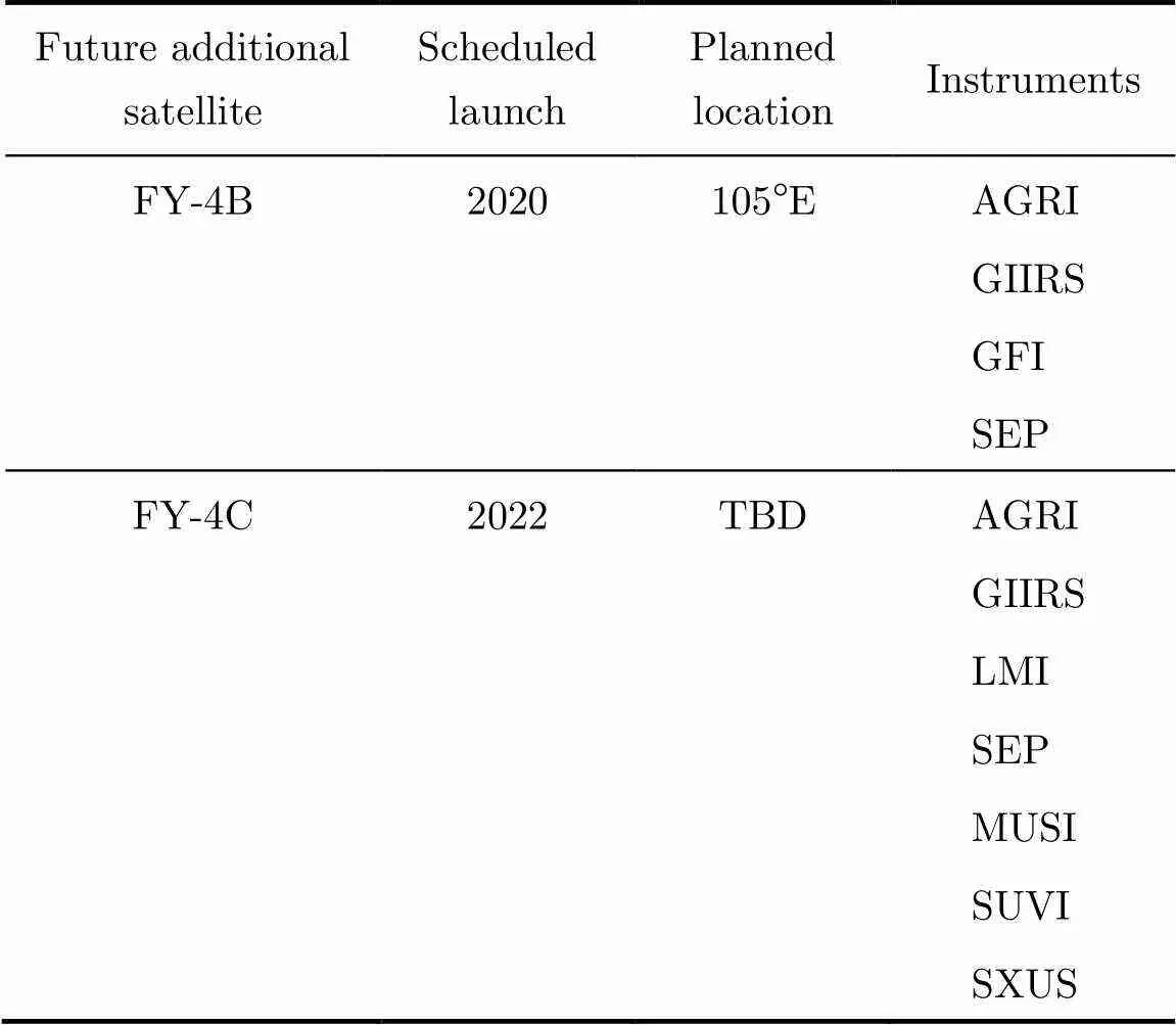
Table 6 Future Fengyun geostationary satellites
8 Conclusions
Tremendous efforts have been made for the establishment and improvement of Fengyun GEO and LEO systems. The Fengyun Program is of long term, application-oriented, continuously being developed for the benefit of user community in pursuit of quality Earth Observation data and products for weather, climate, and environmental services.
As the FY-1 C/D polar orbit operational meteorological satellite triumphantly launched and run in 1999 and 2002, the impact of meteorological satellite of China increasingly grows, playing a more and more important role.
Comparing with the achievement in the space segment, great efforts still need to be endeavored for instrument calibration, product generation, and scientific applications. For the instrument calibration, limited by the insufficient capability of the on-board calibrator of Fengyun satellites, the vicarious calibration, such as Simultaneous Nadir Overpasses (SNO), Pseudo-Invariant Calibration Sites (PICS), Deep Convective Clouds (DCC), the lunar calibration, etc. which recommended by the CEOS WGCV and the Global Space-based Inter-Calibration System (GSICS), should be implemented to monitor and validate the Fengyun satellite radiometric data performance for the whole lifetime. For the product generation, responding to the requirements of global climate observation, the long-term Climate Data Records (CDRs) should be considered to process and re-process on a regular basis. With the concrete improvements from the data pre-processing, the product processing and re-processing of the Fengyun satellites, the consolidated and enlarged applications will be expected.
[1] ZHANG P, LU Q F, HU X Q,. Latest progress of the Chinese meteorological satellite program and core data processing technologies [J]., 2019, 36(9):1027-1045
[2] YANG Z D, ZHANG P, GU S Y,. Capability of FY-3D satellite in Earth system observation [J]., 2019, 33(6):1113-1130
[3] ZHANG Peng, CHEN Lin, XIAN Di, XU Zhe. Recent progress of Fengyun meteorology satellites [J]., 2018, 38(5):788-796
[4] WANG T, GAO T, ZHANG H,. Atmospheric science study in China in recent 70 years: Atmospheric physics and atmospheric environment [J]., 2019, 62
[5] Yang Jun, Zhang Zhiqing, WEI Caiying,. Introducing the new generation of Chinese geostationary weather satellites Fengyun-4 (FY-4) [J].., 2017, 98(8):1636-1658
[6] ZHANG P, ZHU L, TANG S L,. General comparison of FY-4A/AGRI with other GEO/LEO Instruments and its potential and challenges in non-meteorological applications [J]., 2019, 6:224
[7] XIAN D, ZHANG P, FANG M,. The first Fengyun satellite international user conference [J]., 2020 (in press)
[8] National Satellite Meteorological Center. Fengyun3-03 User Requirement Specification [R]. Beijing: National Satellite Meteorological Center, 2015
[9] National Satellite Meteorological Center. Fengyun4-02 Requirement Specification [R]. Beijing: National Satellite Meteorological Center, 2019
P 351
ZHANG Peng, CHEN Lin, XIAN Di, XU Zhe, GUAN Min. Update on Fengyun Meteorological Satellite Program and Development., 2020, 40(5): 884-897. DOI:10.11728/cjss2020.05.884
* Supported by the National Key Research and Development Program of China (2018YFB0504900, 2018YFB0504905)
March 20, 2020
E-mail: zhangp@cma.gov.cn
猜你喜欢
哈尔滨轴承(2022年1期)2022-05-23
北京测绘(2021年7期)2021-07-28
房地产导刊(2020年12期)2021-01-14
房地产导刊(2020年12期)2021-01-14
学生导报·东方少年(2019年7期)2019-06-11
作文周刊·高一版(2019年12期)2019-04-29
数学学习与研究(2017年11期)2017-06-20
青年时代(2017年3期)2017-02-17
大众科学(2016年11期)2016-11-30
科学启蒙(2015年9期)2015-09-25
- 空间科学学报的其它文章
- SJ-10 Recoverable Satellite for Space Microgravity Experiments*
- Taiji-1 Satellite Mission*
- Progress Report on Insight-HXMT: China’s First X-ray Astronomy Satellite
- Progress of the Quantum Experiment Science Satellite (QUESS) Micius Project
- Space Solar Physics in China*
- Current Status and Main Scientific Results of In-flight CSES Mission*