豫西黄土区矿山人为坡沟水土流失特征研究
2020-10-12 22:45:23姚贵奇吴卿何洪名徐建昭双瑞解翼阳李泮营张岩
人民黄河
2020年6期
姚贵奇 吴卿 何洪名 徐建昭 双瑞 解翼阳 李泮营 张岩


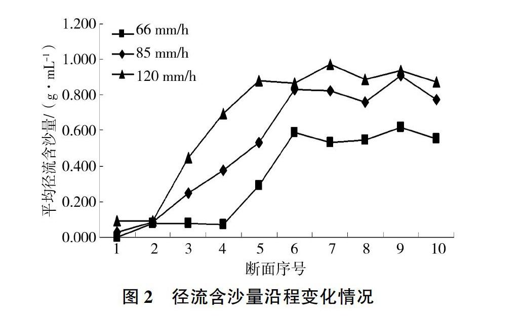
摘 要:礦山开采形成的坡沟是矿区人为新增水土流失的重要部位和重点防治区域,为了给矿区水土保持综合治理提供科学依据,以豫西黄土区矿山人为坡沟为研究对象,利用概化的黄土区矿山人为坡沟模型,进行历时60 min,雨强分别为66、85、120 mm/h的人工模拟降雨试验,结果表明:同一雨强下产流量、产沙量、径流含沙量、土壤侵蚀模数、输沙率随降雨历时延长而增大,径流含沙量沿程呈逐渐增大趋势,沟坡径流含沙量整体上较坡面的大;雨强越大,产流量、产沙量、径流含沙量、土壤侵蚀模数、输沙率越大,径流含沙量沿程增速越快、增幅越大。应在坡面及其上游、沟道两侧采取截排水措施,将坡面径流有效导向下游,防止径流冲刷坡面和沟道。
关键词:矿山人为坡沟;水土流失特征;人工降雨;产流产沙;模型试验;豫西黄土区
中图分类号:S157.1文献标志码:A
doi:10.3969/j.issn.1000-1379.2020.06.019
Study on Characteristics of Soil Erosionin Mine Artificial Slope and Gully in
Loess Region of Western Henan Province
YAO Guiqi1, WU Qing2, HE Hongming2, XU Jianzhao1, SHUANG Rui1, XIE Yiyang3, LI Panying1, ZHANG Yan1
(1.Soil and Water Conservation Monitoring Station of Henan Province, Zhengzhou 450003, China;
2.North China University of Water Resources and Electric Power, Zhengzhou 450046, China;
3.Yellow River Engineering Consulting Co., Ltd., Zhengzhou 450003, China)
Abstract:The slope and gully formed by mining is an important part of artificial soil erosion and the key prevention and control area in the mining area. In order to provide scientific basis for comprehensive control of soil and water conservation in mining area, taking the mine artificial slope and gully in loess region of western Henan Province as a research object, using the generalized model of mine artificial gully in loess region, carrying out the artificial simulated rainfall test with rainfall intensity of 66, 85 and 120 mm/h for 60 min, the results show that: runoff, sediment yield, runoff sediment content, soil erosion modulus and sediment transport rate are increased with the extension of rainfall duration under the same rainfall intensity, the sediment concentration along the river shows the trend of gradually increasing, the sediment concentration of gully runoff on the whole is greater than that of slope surface. When the rainfall intensity is greater, runoff, sediment yield, runoff sediment concentration, soil erosion modulus and sediment transport rate are greater and the runoff sediment concentration along the river is faster and greater. Drainage interception should be taken on the both sides of slopes and the upstream area to effectively guide the runoff to the downstream for preventing slope surface and gully erosion.
Key words: mine artificial slope gully; characteristics of soil erosion; artificial rainfall; runoff and sediment production; model test; loess region of western Henan Province
河南省矿产资源种类及储量丰富,已开发利用90余种,采选业工业增加值高于全国平均水平。豫西是河南省矿产资源分布及开采的重要地区,形成了煤炭、铝土矿、钼矿、金矿、水泥灰岩矿等开采基地,对区域社会经济发展起到了重要作用[1-2]。豫西黄土丘陵区面积约2.78万km2,水土流失严重,土壤侵蚀模数2 000~5 000 t/(km2·a),最高可达10 000 t/(km2·a)[3]。矿山开采导致局部区域生态更加脆弱、人为水土流失加剧,特别是矿山开采形成的坡沟、排土场堆弃体及其裸露坡面,是矿区人为新增水土流失的重要部位和防治的重点区域[4-5]。……
登录APP查看全文