
Palaeogeographic reconstruction of a fluvio-marine transitional system in Narmada rift basin,India-Implications on Late Cretaceous global sea-level rise
2021-03-19 08:00BiplabBhattacharyaSuparnaJhaandPrantikMondal
Journal of Palaeogeography 2021年1期
Biplab Bhattacharya,Suparna Jha and Prantik Mondal
Abstract Rising sea-levels in tectonically active epicontinental basins often lead to varied depositional settings and palaeogeography, mostly influenced by the net accommodation resulting from mutual interference of the extent and nature of landward encroachment by the sea and the net sedimentation. The Cenomanian Nimar Sandstone Formation, Bagh Group, Narmada rift basin, uniquely portrays the effect of sea-level rise within an intra-cratonic setting and attributes to the corresponding palaeogeographic changes in west-central India. An integrated sedimentological-sequence-stratigraphic study of the broadly fining-upward Nimar Sandstone Formation (thickness~20-30 m) depicts the actual nature of changeover from a fluvial to a marine-dominated transitional depositional setting. Detailed sedimentological study reveals total seventeen facies, grouped in five facies associations, viz., the channel-fill facies association (FA-1), the overbank facies association (FA-2), the fluvial-dominated fluvio-tidal facies association (FA-3), the tide-dominated fluvio-tidal facies association (FA-4), and the shoreface facies association (FA-5). Overall facies architecture indicates a west-to-eastward marine encroachment, resulting in stacking of three distinct palaeo-depositional conditions: (i) an initial fluvial system with channel and overbank, changing into a tideinfluenced fluvial bay-head delta in the inner estuary, followed by (ii) marine encroachment leading to a tidedominated central estuary with inter- to sub-tidal settings, and finally, (iii) with further intense marine encroachments, a wave-reworked open shore condition in the outer estuary zone. The overall fining-up succession with a systematic change from fluvial to marine-dominated depositional systems points to a landward shift of the shoreline, signifying a major transgressive event correlated to the Cenomanian global sea-level rise. Characteristic stratal stacking patterns point to four coarsening- and fining-up hemicycles, embedded within the major transgressive succession. These high-frequency cycles attest to the varied interplay of sedimentation, tectonics and sea-level changes, and the resultant net accommodations. A palaeogeographic model is proposed based on the high-frequency transgressive-regressive hemicycles, which envisages the evolution of the depositional environments in relation to the Cenomanian eustatic rise in the intra-cratonic riftogenic fluvio-marine transitional basinal setup.
Keywords: Late Cretaceous, Fluvial-estuary transition, Nimar Sandstone Formation, Bagh Group,Narmada rift basin,Transgressive-regressive cycles,Global sea-level
1 Introduction
The Late Cretaceous time interval is known for intense tectonic activities and significant changes in climatic conditions (Miller et al. 2005; Sames et al. 2016) accompanied by prolonged sea-level rises, leading to worldwide inundations of landmasses (Hancock and Kauffman 1979; Förster et al. 1983; Hilbrecht et al. 1986; Haq et al.1987; Hallam 1992; Röper and Rothgaenger 1995; Miller et al. 2005; Haq 2014). Several parts of different continents were affected by transgressions during the Late Cretaceous time, including parts of Arctic Canada,Russia, western Europe, eastern Australia, parts of Africa, South America, India, Madagascar, and Borneo.Most of the subcontinents of the supercontinent Gondwanaland were fully or partially submerged at different time intervals during the Late Cretaceous, which led to the formation of shallow epicontinental seas in certain areas. Evidence of Cretaceous sea-level rise in the Indian subcontinent is recorded within thick sedimentary successions of the Cauvery Basin (Nagendra et al. 2011, 2013), Shillong Basin (Singh and Mishra 2000), Kutch Basin (Desai 2013), Bengal-Assam Basin,parts of the Himalayan fold belt, and the Narmada rift basin in west-central India (Acharya and Lahiri 1991;Banerjee et al. 2020).
Such global eustatic changes generally manifest 1st-2ndorder sea-level cycles affecting most of the continents, which allow for their successful correlations.However, associated higher-frequency cycles (3rdorder,4thorder and beyond), included in the 2ndorder cycles,mostly depend on changes in relative sea-level and net accommodation caused by basin-scale tectonism, sedimentations and/or climatic/orbital forcings (Vail et al.1991; Gale et al. 2002; Haq 2014; Bhattacharya and Bhattacharya 2015). The Cenomanian Stage (98.9-93.5 Ma) provides a suitable window to study such changes,as high-resolution global correlations (100-400 kyr) in terms of sea-level changes and orbital cycles from marine successions revealed five major/minor eustatic events(KCe-1 to KCe-5 of Haq 2014). However, doubt persists regarding actual nature and effect of transgressions in shallow marine and continent-margin transitional depositional areas, and the role of climatic forcings, tectonism,and sedimentation in controlling palaeogeography and shaping resultant stratal stacking patterns (Bhattacharya et al. 2018). High-resolution sequence-stratigraphic study backed by detailed sedimentary facies analysis is useful to understand the appropriate transitional relationship between fluvial and marine processes in terms of major transgressive-regressive cycles in response to tectonoeustatic changes in such basins (Bhattacharya et al. 2018;Jaiswal et al.2018).
History of sea-level fluctuations during the Cenomanian time in the southern part of the Indian subcontinent(Cauvery Basin) was documented by Sundaram et al.(2001), Skelton (2003), and Gale et al. (2002). However,the effects may vary significantly in fluvio-marine interactive systems depending on the prevalent tectonosedimentary equilibrium. Though attempts to understand the nature of the transition between fluvial and marine depositional systems are plenty in the literature (Dalrymple et al. 1992; Greb and Martino 2005; Dalrymple and Choi 2007; van den Berg et al. 2007; Bhattacharya et al. 2012;Bhattacharya and Banerjee 2015;Bhattacharya and Bhattacharya 2015; Bhattacharya et al. 2018; Richards and Bhattacharya 2018; Gugliotta et al. 2019; and references therein), gaps persist in the actual perception of basinscale facies architecture and stratal stacking pattern related to characteristic tectono-sedimentary attributes in shallow epicontinental basins.
The Nimar Sandstone (Cenomanian) Formation, the lowermost litho-unit within the Bagh Group (Late Cretaceous), bears signatures of the contemporary global sea-level rise in west-central India (Jha et al. 2017). Signatures of the Late Cretaceous marine transgression in the Bagh Group are evident and agreed well in terms of different proxies such as sedimentary attributes, palaeontological data, ichnological data, micropalaeontological data and palaeobotanical data (Murty et al. 1963;Chiplonkar and Ghare 1975; Raiverman 1975; Badve and Ghare 1980; Singh and Srivastava 1981; Jafar 1982; Bose and Das 1986; Ganguly and Bardhan 1993; Sanganwar and Kundal 1997; Khosla et al. 2003; Smith 2010; Jaitly and Ajane 2013; Bhattacharya and Jha 2014; Jha et al.2017; Bansal et al. 2019; and many others). But, a comprehensive sequence stratigraphic model enumerating the actual nature of coastal onlap and the fluvial-marine interaction has not been attempted and is long overdue.The objective of the present paper is to document the palaeogeographic changes under the fluvio-marine interactive depositional system in the light of high-frequency transgressive-regressive (T-R) cycles. The proposed model will help to understand the effects of higherfrequency sea-level fluctuations in fluvio-marine transitional systems within a global eustatic rise condition.
2 Geological setting
The deposition of the Bagh Group (Late Cretaceous) was started within the Narmada rift basin during the Cenomanian time, directly overlying the Proterozoic Bijawar Group.The Bagh Group is constituted of three litho-units(formations), namely, the lowermost Cenomanian Nimar Sandstone Formation, followed by the Turonian Nodular Limestone Formation,and Coniacian Coralline Limestone Formation at the top(Table 1).In the Narmada rift basin,the Bagh Group is overlain by the Lameta Formation and the Deccan Traps,both of Late Cretaceous age.The presence of various sedimentary facies, ichnofabrics, andvaried palaeontological attributes within the Bagh Group manifests distinct changes in the depositional environment.The rocks are exposed along the northern flank of the Narmada rift basin and occur in patches (Fig. 1). Rocks of the Nimar Sandstone Formation are well exposed in several sections including the Man River near Awaldaman,Sitapuri,Bagh River,Rampura,Bagh Cave,Jobat,and other areas (detail of locations is given in Fig. 1). The Nimar Sandstone Formation is characterized by conglomerate,arenaceous to arkosic sandstone, sandstone-mudstone heteroliths, and mudstone. In the study area, the general strike of beds is N15°E-S15°W to N-S with a dip of 8°-10°. The depositional age of the Nimar Sandstone Formation is considered as Cenomanian (Jaitly and Ajane 2013),which has been determined mostly based on biostratigraphic records preserved in the upper part of the succession (Table 2). However,data depicting the absolute age of deposition of the Nimar Sandstone Formation is lacking till date.
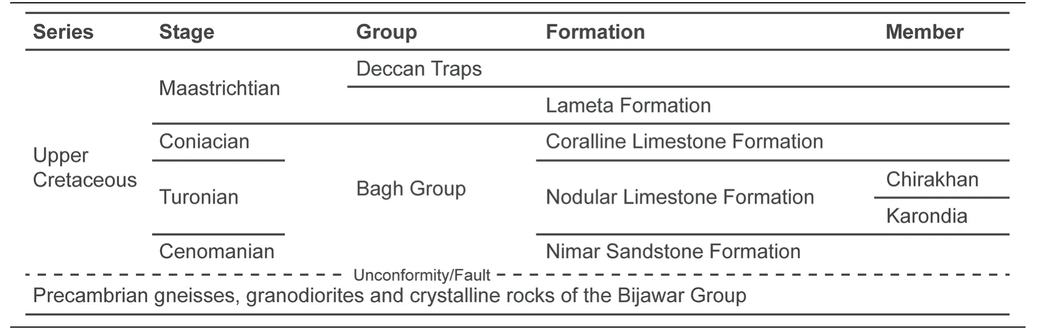
Table 1 Generalized lithostratigraphy of the study area (modified after Singh and Srivastava 1981; Jaitly and Ajane 2013)
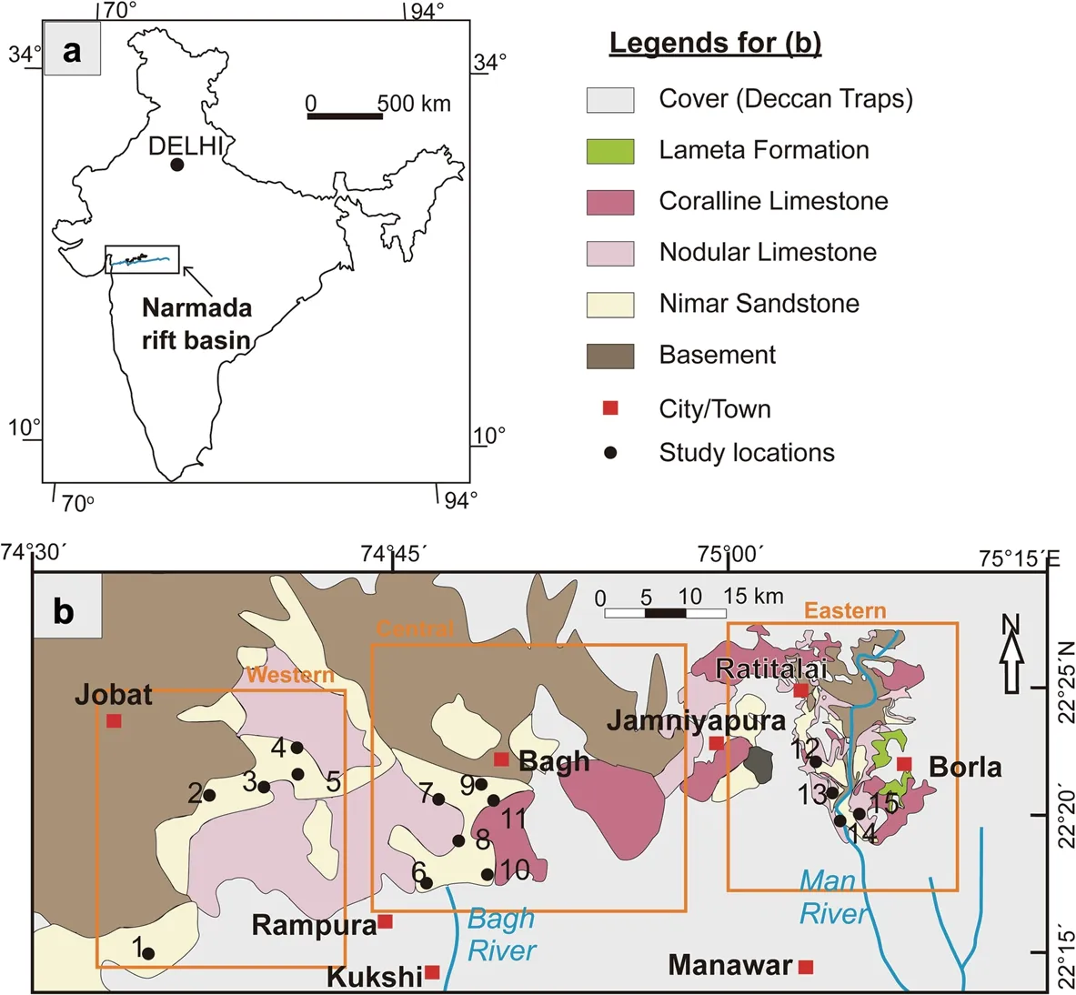
Fig. 1 a Map of India showing location of the Narmada rift basin; b Geological map of the study area (modified after Jaitly and Ajane 2013),showing distribution of the Bagh Group. Black points marked with numbers (1-15) indicate locations/areas of exposed rock sections from where respective vertical sedimentary lithologs were prepared: 1-Phata; 2-Ghoda; 3-Chikapoti; 4-Dhursal; 5-Akhara; 6-Rampura; 7-Baghini Temple; 8-Bagh;9-Neemkheda; 10-Dam;11-Raisinghpura; 12-Ratitalai;13-Baria; 14-Man River;15-Sitapuri
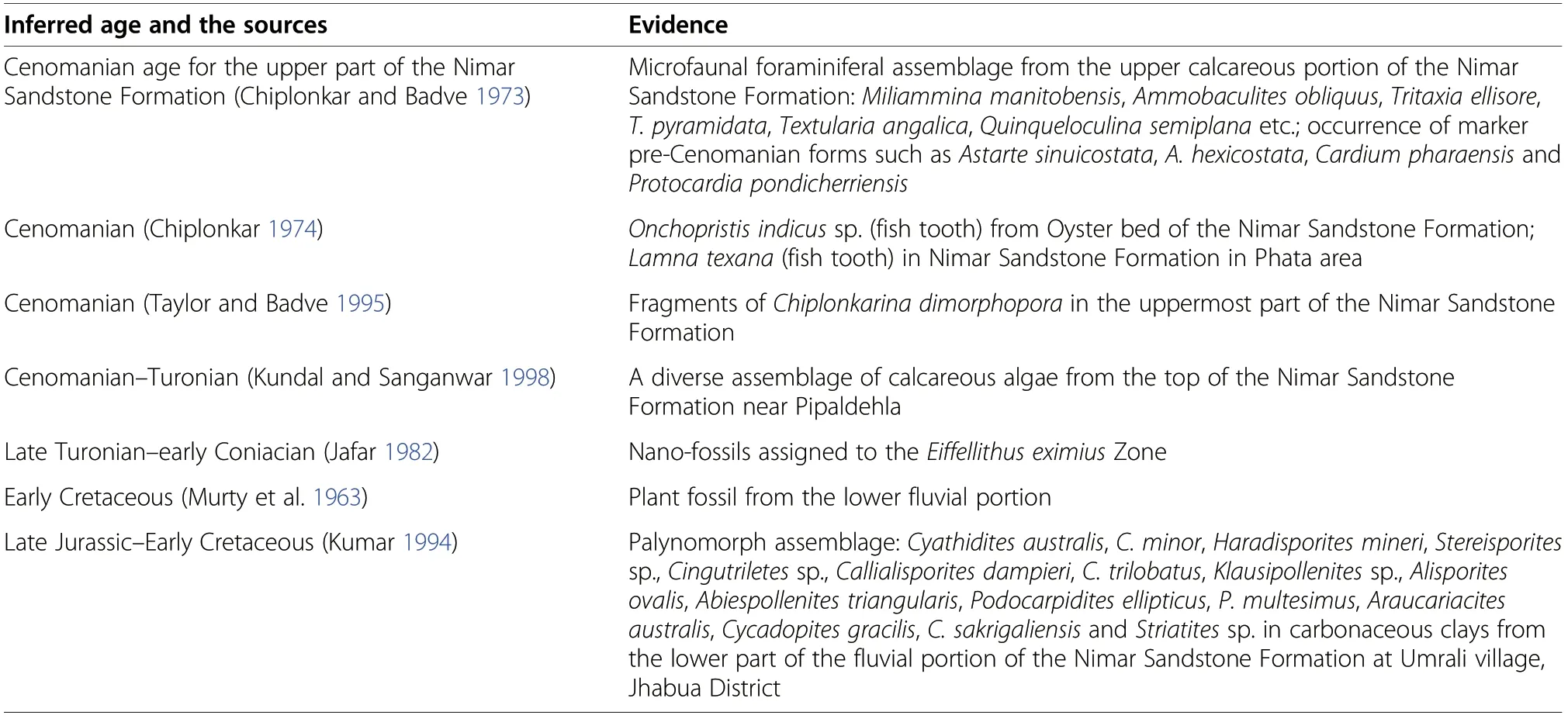
Table 2 Inferred depositional age of the Nimar Sandstone Formation based on biostratigraphic studies
3 Material and methods
Unmetamorphosed, undeformed siliciclastic rocks of the Nimar Sandstone Formation are well exposed in and around the Bagh area (Fig. 1) in the western part of the state of Madhya Pradesh, central India. Well-exposed,long sections are available in the field for detailed sedimentological study. Altogether 15 sections were studied,distributed in three zones in the study area: (i) Awaldaman, Ratitalai, Sitapuri, Baria, etc. in the eastern part, (ii)Bagh, Rampura, Raisinghpura, etc. in the central part,and (iii) Chikapoti, Akhara, Phata, Ghoda, etc. in the western part.
The sedimentological study is primarily based on (i)facies analysis, which includes descriptions andinterpretations of facies types and facies associations in the frame of prevalent process-response models and mechanisms of deposition, and (ii) preparation of lithologs from different parts and their correlation to understand the spatio-temporal distribution of different facies types and the depositional conditions.
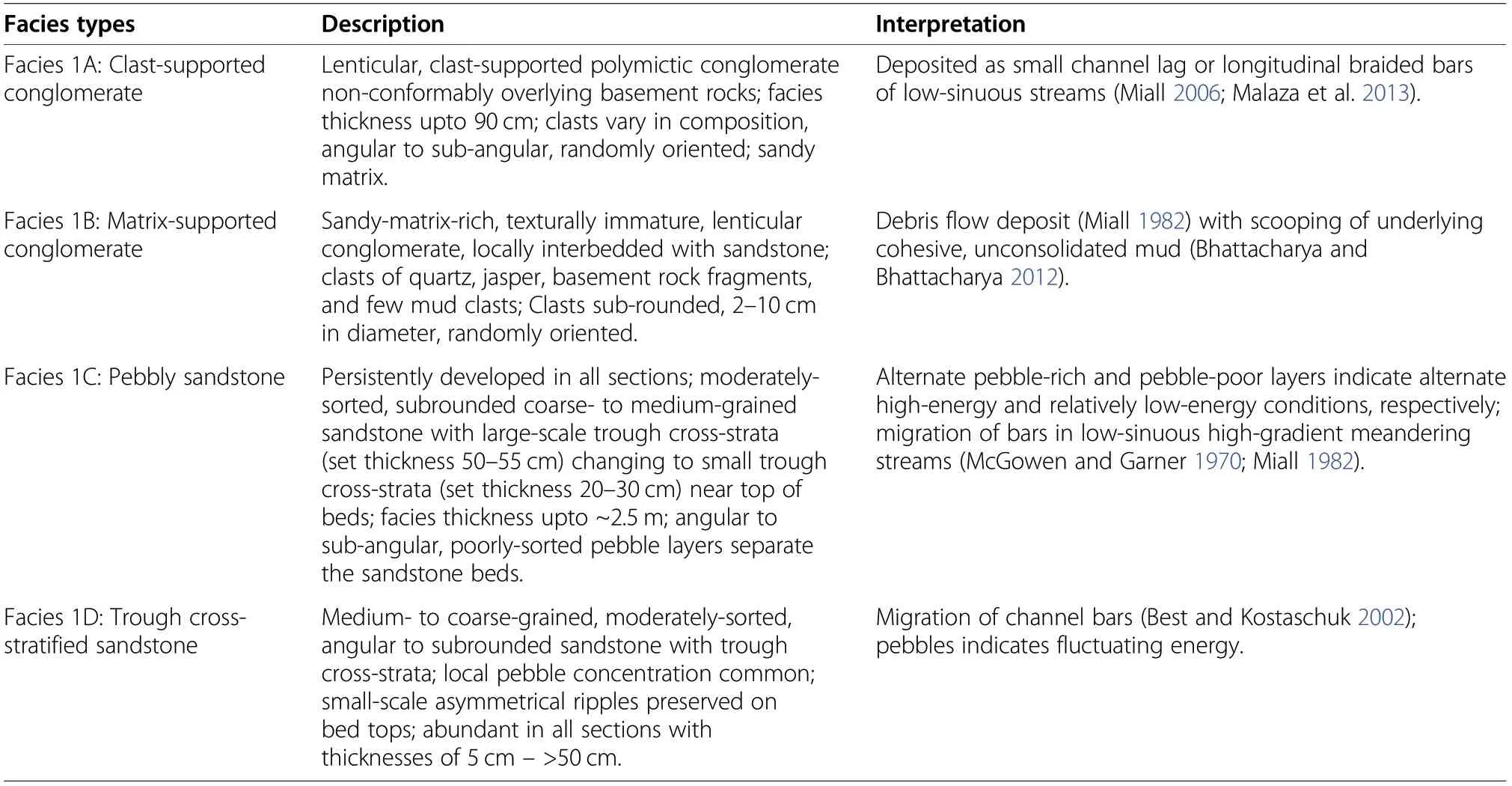
Table 3 Brief descriptions and interpretations of the facies types within the channel-fill facies association(FA-1)
The sequence-stratigraphic study is primarily based on the identification and interpretation of different stratal stacking patterns, viz., coarsening-up (progradational)and fining-up (retrogradational), in the correlated sections, followed by the interpretation of sediment packages (cycles) of different frequencies.
4 Results
4.1 Sedimentological facies architecture
Sedimentologically, the siliciclastic succession of the Nimar Sandstone Formation (average ~20-30 m thick)is represented by seventeen facies types grouped in five distinct facies associations (FA-1-FA-5). Brief descriptions and interpretations of the facies types in different facies associations are depicted in Tables 3, 4, 5, 6 and 7,respectively. Representative photographs of the facies types of different facies associations (FA-1-FA-5) are represented in Figs. 2, 3, 4,5 and 6, respectively.
Facies association FA-1 (Fig. 2) consists of four facies types, viz., the clast-supported conglomerate (facies 1A),the matrix-supported conglomerate(facies 1B),the pebbly sandstone(facies 1C)and the trough cross-stratified sandstone (facies 1D) (see Table 3). All the facies types are characterized by a very coarse-grained immature nature with an abundance of pebbles. Facies types mostly conform to large channel geometries with occasional sharp erosional basal contacts. The sediment fill pattern in individual channel geometries depicts an abundance of pebbles near the basal part often associated with large trough cross-strata, changing to smaller trough cross-strata in coarse-grained sandstone in the upper part. Overall facies architecture of FA-1 indicates a channel-fill facies association where sedimentation took place as channel-filling basal lag to point bar in a low-sinuosity meandering stream of relatively high energy.
The facies association FA-2 (Table 4; Fig. 3) is characterized by relatively fine-grained rocks. It is consisted of interbedded sandstone-mudstone (facies 2A) and planelaminated sandstone (facies 2B). The facies types are characterized by an overall sheet-like geometry with alternations of thin-bedded, plane-laminated to ripple cross-stratified sandstone grading to mudstone. Such geometry and the close association of this facies association with channel-fill facies association (FA-1) indicate deposition of FA-2 sediments in overbank areas of channels.
The facies types in the facies association FA-3(Table 5; Fig. 4) include the large-scale trough crossstratified sandstone (facies 3A) and the planar crossstratified sandstone (facies 3B), which characteristically bear mud-draped foresets,and lateral accretion of ripple cross-sets with reactivation surfaces within channel-fill cross-stratified sandstone beds. Such signatures indicate tidal influence (Bhattacharya et al. 2015, 2018) within a fluvial-dominated fluvio-tidal depositional setting.
The facies association FA-4 (Table 6; Fig. 5) consists of five different facies types, namely, the heterolithic sandstone-mudstone (facies 4A), the mud-clast-bearing conglomerate (facies 4B), the plane-laminated sandstone(facies 4C), the bioturbated sandstone (facies 4D) and the green sandstone (facies 4E). Abundant bi-directional ripple and climbing ripple cross-strata with mud-draped foresets, presence of glauconite in sandstone, trough cross-strata in sandstone with abundant mud, and an abundance of marine invertebrate trace fossils, etc. all indicate a strong tidal control within the fluvial system during the sedimentation of the tide-dominated fluviotidal facies association (FA-4).
The facies association FA-5 (Table 7; Fig. 6) is represented by the fossil-bearing sandstone (facies 5A), the
Thalassinoides-Ophiomorpha-bearing thinly-laminated sandstone-mudstone (facies 5B), the wave-ripplebearing sandstone (facies 5C) and the massive mudstone(facies 5D). The abundance of symmetrical wave ripples, presence of marine invertebrate fossils and trace fossils, and the prevalence of both sand and mud are the characteristics of this facies association, whichtogether indicate a significant amount of wave influence during deposition of the shoreface facies association (FA-5).
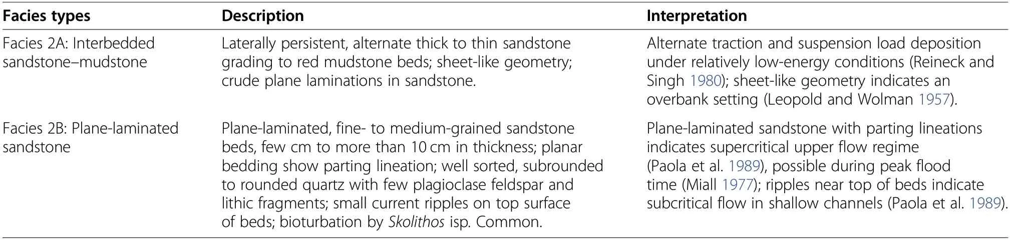
Table 4 Brief descriptions and interpretations of facies types within the overbank facies association (FA-2)
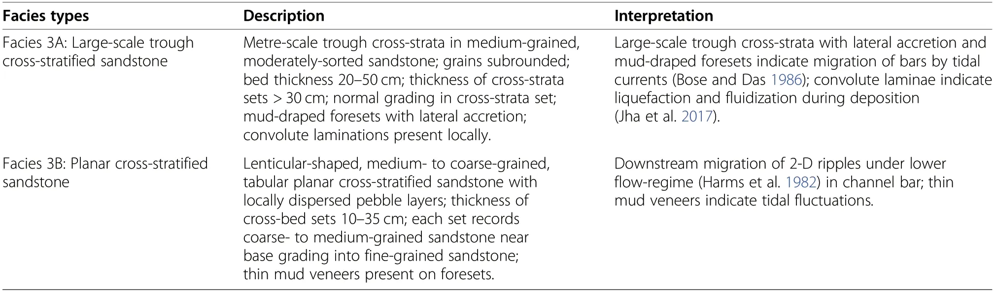
Table 5 Brief descriptions and interpretation of facies types within the fluvial-dominated fluvio-tidal facies association (FA-3)
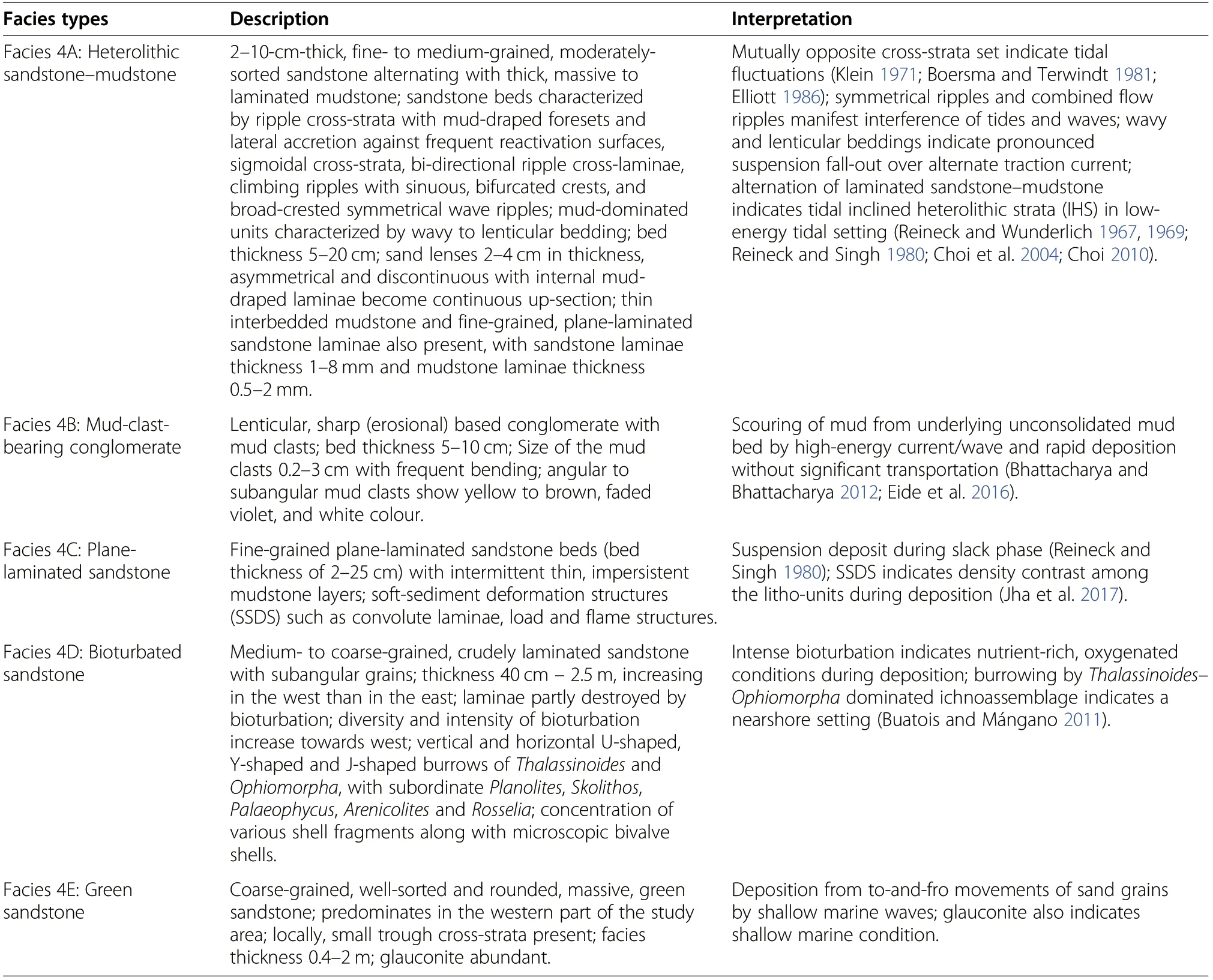
Table 6 Brief descriptions and interpretation of facies types under the tide-dominated fluvio-tidal facies association (FA-4)
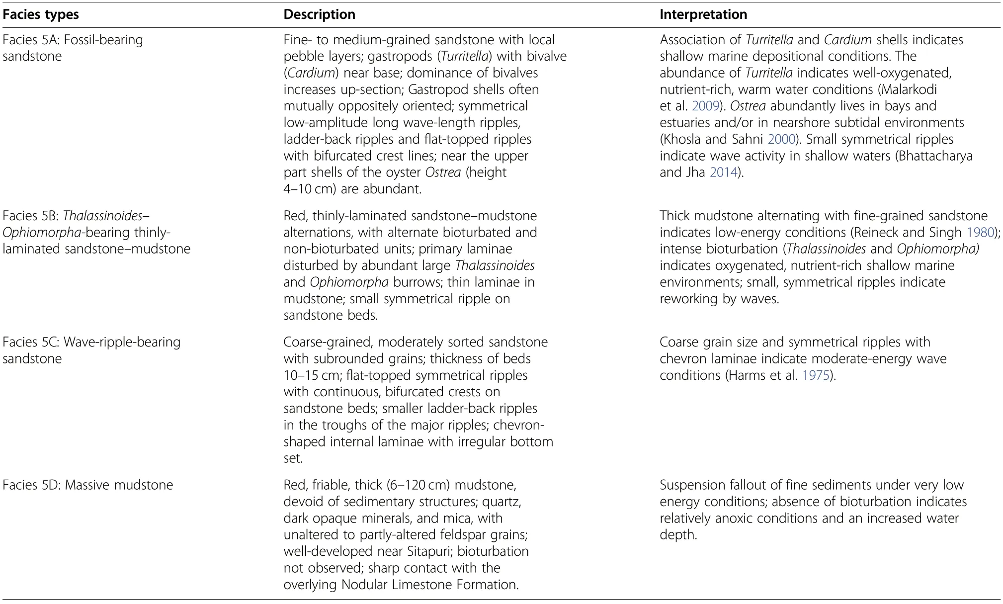
Table 7 Brief descriptions and interpretation of facies types under the shoreface facies association (FA-5)

Fig. 2 Field photographs. a Clast-supported conglomerate (facies 1A) showing angular to sub-angular clasts of basement gneissic rock, exposed in the Rampura section. Length of pen is 14.5 cm. b Matrix-supported conglomerate (facies 1B), exposed in Bagh section. Arrows indicate occurrence of mud clasts. Diameter of coin is 2.5 cm. c Pebbly sandstone (facies 1C) showing alternate pebble-rich and pebble-free sandstone beds, exposed in the Neemkheda section. Length of pen is 15 cm. d Trough cross-stratified sandstone (facies 1D), exposed along the river bank of Baria section.Length of hammer is 30.5 cm
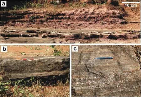
Fig. 3 a Field photograph of interbedded sandstone-mudstone (facies 2A), near Raisinghpura. b Field photograph of the plane-laminated sandstone (facies 2B), Man River section. Length of pen is 14.5 cm. c Cross-section of the plane-laminated sandstone facies showing welldeveloped plane beds.Length of pen is 15 cm
Detailed vertical sedimentary logs, showing the occurrence of facies types and facies associations in the 15 sections, from the western, central, and eastern parts of the study area are presented in Figs. 7, 8 and 9, respectively. These logs reveal that —
i) the lower part of the succession is mostly comprised of immature sediments of FA-1and FA-2,and is overlain by
ii) sediments of the fluvial-dominated fluvio-tidal facies association (FA-3), gradually changing vertically and laterally into sediments of the tide-dominated fluviotidal facies association (FA-4), commonly occupying the middle part of the succession and,finally,

Fig. 4 a Field photographs of large-scale trough cross-stratified sandstone(facies 3A)along the western bank of the Man River section.Arrows show lateral accretion surfaces.b Field photograph of planar cross-stratified sandstone(facies 3B),Man River section.Length of hammer is 30.5 cm
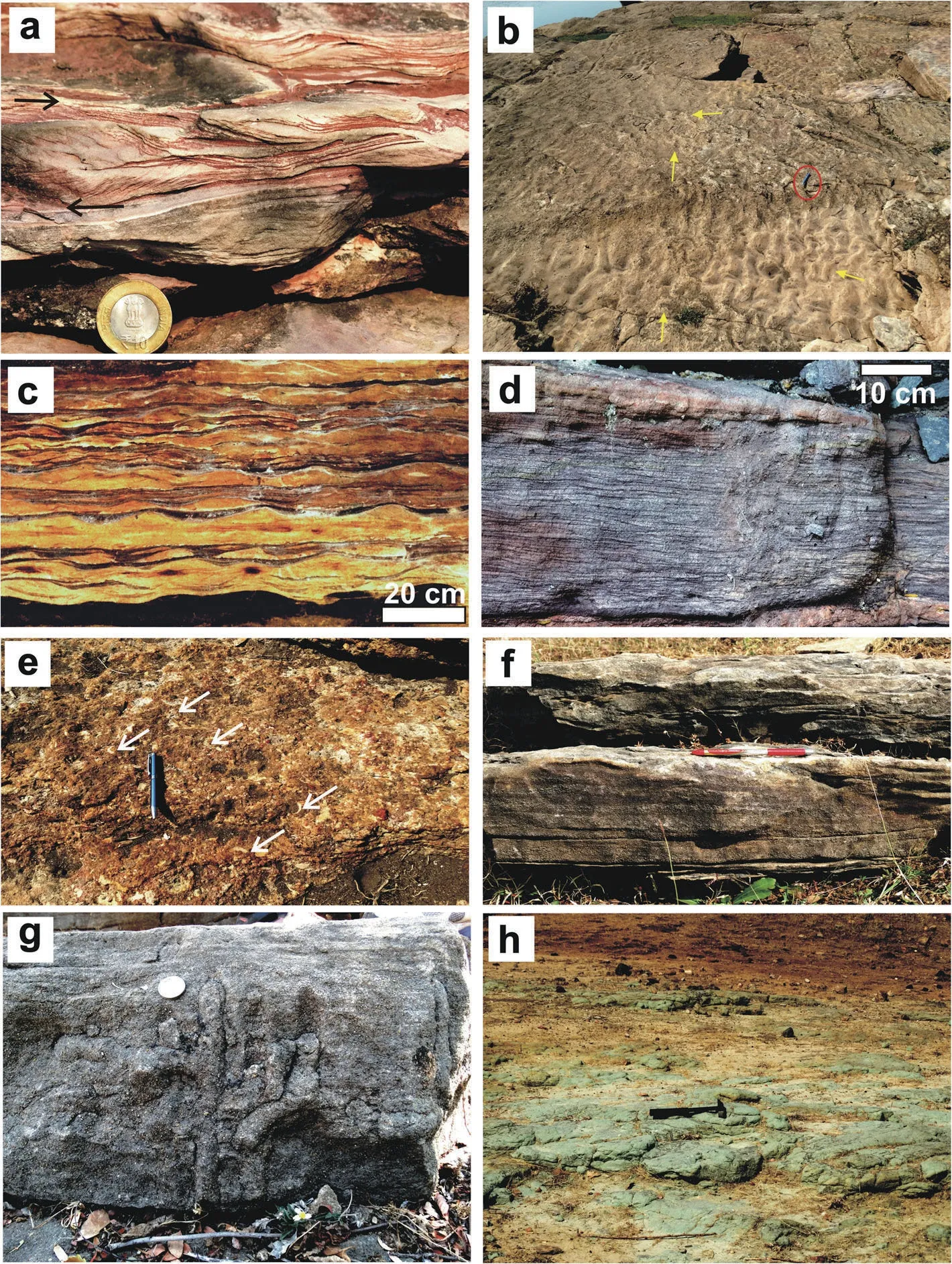
Fig. 5 Field photographs. a Heterolithic sandstone-mudstone (facies 4A) showing presence of mud drapes and poorly-developed bidirectional cross-strata, Man River section. The arrows indicate apparent orientation of the foresets in adjacent cross-strata sets. Diameter of coin is 2.5 cm. b Interference ripples with bifurcation of crest line (yellow arrows) on the sandstone bedding surface of facies 4A, Man River section. Length of pen (encircled) is 14.5 cm. c Lenticular and wavy bedding developed within facies 4A, preserved in Bagh Cave. d Inclined heterolithic strata developed within facies 4A, Man River section. e Mud-clast-bearing conglomerate (facies 4B) showing angular mud clasts (arrows), Man River section. Length of pen is 14.5 cm. f Plane-laminated sandstone (facies 4C), Ratitalai section. Length of the pen is 14.5 cm. g Bioturbated sandstone (facies 4D), Akhara section. Diameter of coin is 2.5 cm. h Green sandstone facies (4E), exposed in Ghoda area. Length of hammer is 30.5 cm
iii) sediments of the shoreface facies association (FA-5)predominate along with tide-dominated facies associations(mostly FA-4)in the upper part of the succession.
At different stratigraphic levels in the middle part of the studied succession, layers with various soft-sediment deformation structures (SSDS), e.g., convoluted laminae,pseudo-nodules, load and flame structures, synsedimentary faults, slumps, and sand dykes, have been recorded by Jha et al. (2017).
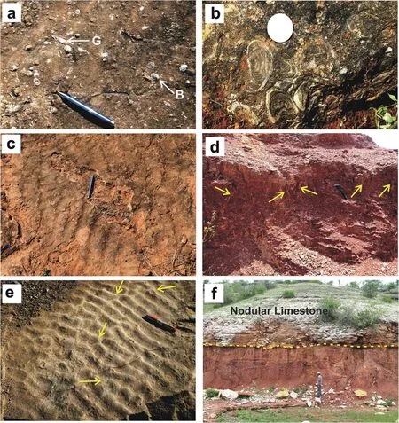
Fig. 6 Field photographs. a Fossil-bearing sandstone (facies 5A) showing gastropod (G) and bivalve shells (B) on sandstone bedding plane, near Akhara.Length of pen is 14.5 cm. b Ostrea shells in facies 5A,occurring near the Bagh-Akhara road.Diameter of coin is 2.5 cm. c Symmetrical flattopped wave ripples with small-scale ladder-back ripples in facies 5A, preserved near Akhara. Length of pen is 14.5 cm. d Thalassinoides-Ophiomorpha-bearing thinly-laminated sandstone-mudstone (facies 5B) showing well-preserved vertical burrows (arrows). The section is exposed near Sitapuri. Length of hammer is 30.5 cm.e Wave-ripple-bearing sandstone (facies 5C) showing symmetrical wave ripples with bifurcating crests(arrows), exposed in the Dam section. Length of pen is 14.5 cm. f Massive mudstone (facies 5D) overlain by white-coloured Nodular Limestone Formation,north of Sitapuri.The contact is marked by dashed yellow line. Man for scale is 170 cm tall
Alternate fluvial (FA-1 and FA-2) and fluvialdominated tidally-influenced sediments (FA-3)followed by tide-dominated wave-reworked sediments(FA-4 and FA-5) constitute distinct depositional cycles within a mixed fluvio-marine depositional setting.Cyclic occurrences of the tidally-influenced sediments of FA-4, overlain by the wave-dominated sediments of FA-5 in the middle-upper part of the succession indicate repeated changes in water-depth over short intervals under a tidal to wave interactive system as a product of periodic marine inundations and intercalations. Such repetitive fining-up cycles indicate the inundation of fluvio-tidal channels by marine waters within a typical estuarine setting (Nichols 2009). In the study area, overall dominance of tidal features over wave features points to a tide-dominated waveinfluenced estuary (Jha et al. 2017).
The overall fining-up character, increasing marine dominance up-section, and prevalence of landward palaeocurrent directions indicate an estuarine setting.Within the fluvio-marine interactive setting, three major sub-environments are envisaged:
i) A fluvial-dominated zone initially, with the transition from fluvial channels (FA-1) to floodplain(FA-2), with few tide-affected fluvial deposits(FA-3) in the basal part of the succession, mainly prevails in the eastern and central part of the study area.
ii) A mixed-energy central estuary zone in the middle-upper part of the succession, which consists of transitional fluvio-tidal channels (FA-3) and tidal flats associated with tidal channels and bars(FA-4) overlying the fluvial systems in the study area.
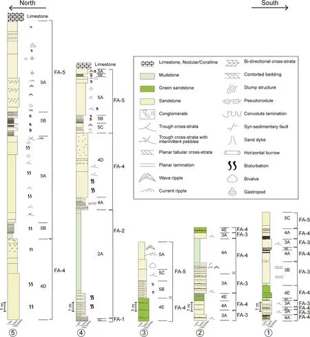
Fig. 7 Lithologs from the western part of the study area (sections 1-5) showing lateral and vertical distribution of various facies types and their associations.For section locations see Fig.1.Legend is the same for Figs.7, 8 and 9
iii) A wave-dominated shore environment in the outer estuary zone (top part of FA-4 with FA-5), occupying the upper part of the succession, occurs dominantly in the west and central part and gradually diminishes towards the eastern part of the study area.
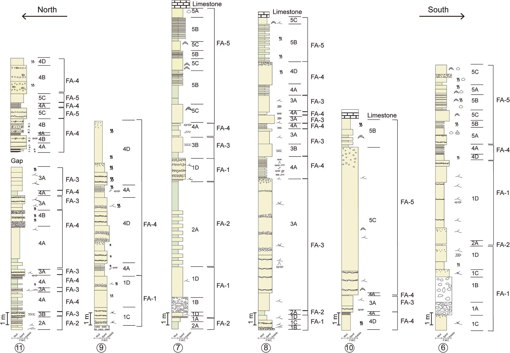
Fig. 8 Lithologs from the central part of the study area (sections 6-11) showing lateral and vertical distribution of various facies types and their associations.For section locations see Fig.1;for legend see Fig.7
The distinct layers with abundant SSDS have been interpreted as seismites by Jha et al. (2017). The seismite layers mark phases of a substantial shift in depositional conditions from fluvial-dominated to a transgressive tidal- and wave-influenced estuarine system related to basinal subsidence caused by reactivation of the Son-Narmada South Fault during sedimentation of the Nimar Sandstone Formation(Jha et al. 2017).
4.2 Stratal stacking patterns and T-R cycles
Vertical and lateral distributions of the litho-units depict an overall fining-upward retrogradational cycle for the entire Nimar Sandstone Formation. Four section correlations are made: (i) in the Akhara-Phata area, the westernmost of the basin, incorporating sections 1-5(Fig. 10); (ii) in the Bagh area, the central of the basin,incorporating sections 6-11 (Fig. 11); (iii) in the Man River-Ratitalai area, the easternmost of the study area,including sections 12-15 (Fig. 12); and (iv) along a nearly dip-parallel section over the whole study area(Fig. 13), incorporating, from west to east, logs of Chikapoti, Akhara, Bagh, Raisinghpura, and Sitapuri.The correlations provide clear evidence of stratal stacking patterns along the length (W-E) and width (NS) of the basin, and reflect the dominance of marineinfluenced facies types in the western logs in comparison to the easternmost ones. Similarly, a gradual diminishing abundance of channel-fill facies types (mostly FA-1) is observed from east to west in the study area. Within the overall fining-up trend, high-frequency alternate coarsening-up (progradational) and fining-up (retrogradational) hemicycles a are visible in almost all the lithologs (Figs. 10,11,12 and 13).
The overall retrogradational pattern with the gradual changeover from dominant fluvial systems in the lower part, followed by mixed fluvial-tidal systems in the middle part and mixed tidal- and wave-dominated open marine systems in the upper part of the studied succession points to the overall transgressive nature of the succession. The transgressive succession is also evident from the systematic change in abundance of fluvial to marine facies from east to west, which signifies a westto eastward marine incursion controlling the sedimentation at different areas. The smaller coarsening- and fining-up hemicycles embedded within this major transgressive cycle manifest high-frequency changes in base level and accommodation.
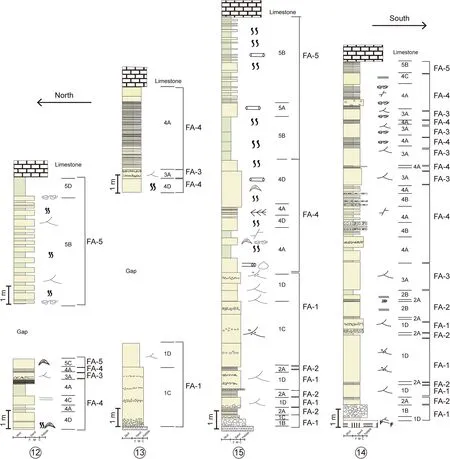
Fig. 9 Lithologs from the eastern part of the study area (sections 12-15) showing lateral and vertical distribution of various facies types and their associations.For section locations see Fig.1;for legend see Fig.7
The Nimar Sandstone Formation is conformably overlain by the Nodular Limestone Formation without any visible break in sedimentation. The Nodular Limestone Formation has been interpreted as a restricted shallow marine platform-tidal flat deposit (Ruidas et al. 2018;Bansal et al. 2019). Thus, it remains inconclusive at this stage whether the major transgressive event that affected the entire Nimar Sandstone Formation succession also continued during the deposition of the overlying limestone units.
4.3 High-frequency T-R cycles
Four distinct high-frequency hemicycles (Figs. 10, 11, 12,13, 14 and 15) are observed within the major transgressive cycle: (i) the lowermost coarsening-up hemicycle(named as L-C), followed up by (ii) a fining-up hemicycle (named as L-F) in the lower-middle part of the succession, (iii) another coarsening-up hemicycle(named as U-C) in the middle-upper part of the succession, and (iv) an upper fining-up hemicycle (named as UF)occurring near the top of the entire succession.
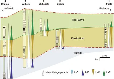
Fig. 10 Correlation of lithologs in the western part of the study area (see Fig. 1 for location), showing transgressive-regressive (T-R) cycles of different orders. U-C: Upper coarsening-up hemicycle; U-F: Upper fining-up hemicycle; L-C: Lowermost coarsening-up hemicycle; L-F: Lower finning-up hemicycle.Legends are the same for Figs.10, 11, 12 and 13
The lowermost coarsening-up (progradational) hemicycle (L-C) is most prevalent in the central and eastern part of the area (Figs. 11, 12) and depict a stratal stacking pattern formed by the lateral and vertical amalgamation of channel-fill deposits (FA-1), intermittently separated by overbank deposits (FA-2). Overall, FA-1 sediments are much more abundant than FA-2 sediments.
A fining-up (retrogradational) hemicycle (L-F) commonly overlies the L-C hemicycle and occupies the lower to middle part of the succession in the central and eastern parts of the study area (Figs. 11, 12 and 13). However, in the western part,the L-C hemicycle is absent and the succession starts with the L-F hemicycle (Fig. 10). This fining-up succession shows a stratal stacking pattern formed predominantly by overbank deposits (FA-2) with isolated, detached units of channel-fill sediments (FA-1).Overall, the overbank deposits are more abundant than the channel-fill sediments within this hemicycle.
Both L-C and L-F are overlain by another coarsening-up (progradational) hemicycle (U-C),mostly occupying the middle to upper part of the succession. The stratal architecture within this hemicycle depicts a progradational stacking pattern with successively stacked fluvial-dominated fluvio-tidal deposits (FA-3) and intermittent finer-grained tidedominated fluvio-tidal deposits (FA-4) (Fig. 15). Both the channel and the overbank deposits are characterized by abundant tidal signatures. Preserved tidal signatures help to differentiate this hemicycle from earlier hemicycles apart from the change in stacking pattern from fining-up below to coarsening-up above.The coarsening-up stacking pattern is produced by the local amalgamation of tide-affected fluvial channels in the middle and upper part of the U-C hemicycle.

Fig. 11 Correlation of lithologs in the central part of the study area (see Fig. 1 for location), showing different-order T-R cycles. For abbreviations see Fig.10
The topmost fining-up hemicycle (U-F) caps the earlier hemicycles throughout the entire area. A fining-up,retrogradational stratal stacking pattern is observed with an abundance of FA-4 facies types accompanied by FA-5 facies types. Marine depositional signatures are most prevalent within this hemicycle in comparison to all other hemicycles, which include sheet sandstone bodies with abundant wave-produced features, heterolithic units with shallow-marine invertebrate fossils and trace fossils, and thick- to thin-bedded tidal heteroliths. Evidence of fluvial sedimentary processes in terms of facies types of FA-1, FA-2 or FA-3 are lacking or absent within this hemicycle. The thickness of the sediment package of U-F also varies significantly, with maximum thickness and sand-rich composition in the western part, and a gradually diminishing thickness and change to a mudrich composition towards the east. This hemicycle is directly overlain by the Nodular Limestone Formation.
5 Discussion
5.1 Interpretation of the high-frequency T-R cycles
The lowermost coarsening-upward hemicycle (L-C),characterized by highly amalgamated channel-fill units and a high channel/overbank sediment ratio, signifies deposition in unconfined fluvial channels without any connection to marine processes. Lateral and vertical shifts in channel stacking pattern and amalgamation indicate frequent channel avulsion with a significantly low rate of aggradation of overbank deposits. The overall stratal stacking pattern points to a high-amalgamation systems tract (HAST) developed in a lowaccommodation, upstream-controlled fluvial depositional system (Catuneanu 2017).
The overlying fining-up hemicycle (L-F), characterized by stacking pattern dominated by overbank deposits and a low channel/overbank sediment ratio, signifies deposition in confined isolated channels with a low rate of channel avulsion or migration and a high rate of overbank aggradation. Such a stratal stacking pattern is identified as a low-amalgamation systems tract (LAST)(Catuneanu 2017), indicating high accommodation due to basinal subsidence and raised river profile leading to flooding and deposition of finer overbank deposits over the earlier sand-depositing areas. This led to a fining-up retrogradational succession (FA-2 over FA-1) in most areas. The predominance of mud-rich floodplain deposits manifests rising base level conditions, leading to:(i) raising of the river profile, (ii) more deposition than the incision, and (iii) low channel avulsion and aggradation. Such rising of the base level can be considered as an indirect effect of the rising and encroaching sea,which was not far away. Close overlap of this hemicycle by the overlying tide-dominated facies association supports this interpretation.
The stratal stacking pattern and the associated facies architecture in the overlying hemicycles (U-C and U-F)indicate clear signatures of marine influence. Thus, a shift in the depositional conditions from an upstreamcontrolled fluvial setting to a downstream-controlled,marine-influenced transitional setting can be envisaged at the boundary of the L-F hemicycle and the U-C hemicycle. Significant marine influence, in association with basinal tectonics and sediment supply controlled the creation of net accommodation and the resultant stratal stacking patterns. SSDS-bearing beds both above and below the said transition are interpreted as seismites(Jha et al. 2017), which signifies strong control of the basinal tectonism caused by reactivation of faults and basinal sagging in controlling the accommodation and sedimentation (Bhattacharya et al. 2016; Bhattacharya and Saha 2020).
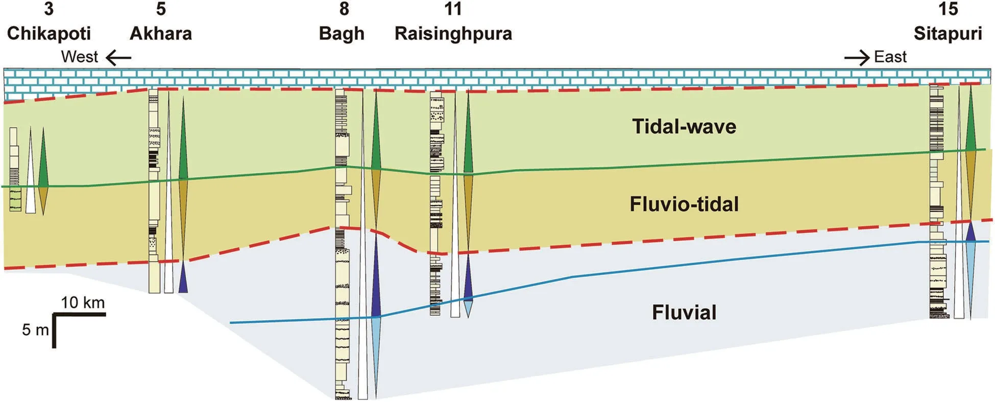
Fig. 13 Correlation of lithologs along a dip section from west to east of the study area (see Fig. 1 for location), showing different-order T-R cycles.For abbreviations see Fig.10
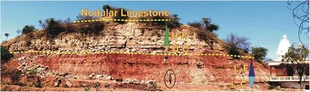
Fig. 14 A representative field section beside the Baghini Temple, near Bagh, showing four transgressive-regressive hemicycles (marked by L-C, LF,U-C and U-F).The person(encircled)is 172 cm tall.For key of abbreviations, see Fig.10
The overlying coarsening-up hemicycle (U-C) in the middle to upper part of the succession, characterized by low to high tidal influence, shows a stacking pattern dominated by tide-reworked channel and overbank deposits (FA-3 and FA-4). Additional accommodation was available, as evident from high-accumulation of the tideaffected overbank deposits (FA-4) and low to high amalgamation of tide-influenced channels (FA-3). This net accommodation creation was controlled by a rising base level and landward encroaching sea, which was overpaced by a high rate of sedimentation led by both fluvial and tidal systems. The overall progradational stratal stacking pattern with less aggradation indicates a regressive condition, equivalent to a lowstand systems tract(LST) in the fluvio-marine transitional setting. In some areas (e.g., Bagh, Rampura, etc., Figs. 11, 13), particularly in places where the fluvial channels were strongly affected by tidal currents during this marine encroachment, tidally reworked coarser-grained clastics led to stacked, amalgamated thick channel-fill sandstone units(of FA-3). Such progradational stacking pattern confirms a lowstand condition, where a significant amount of sediment supplied by river was reworked by the encroaching tidal currents and was deposited as bayhead deltas and tidal bars in river mouth areas.
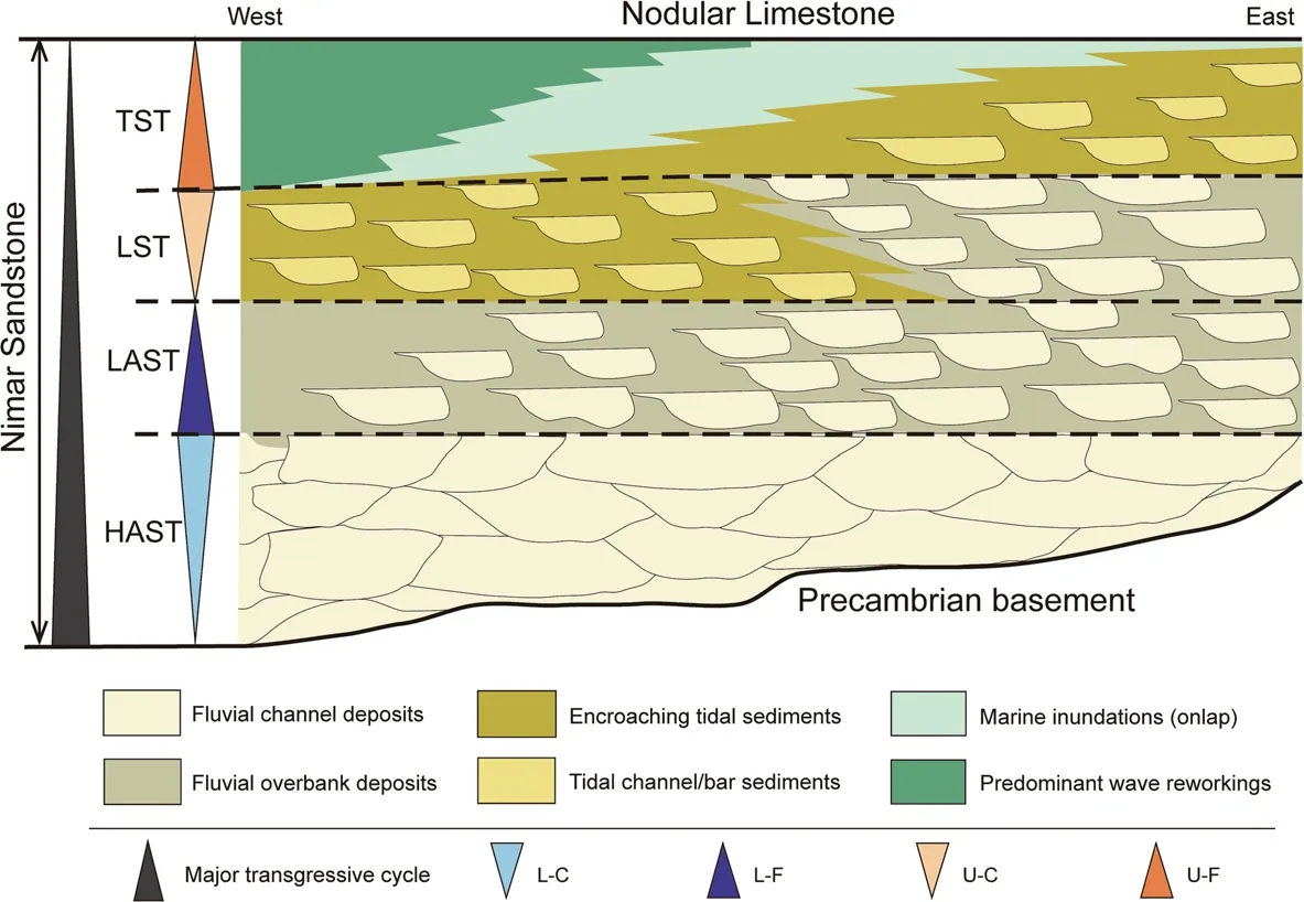
Fig. 15 Conceptual sequence stratigraphic model of the Nimar Sandstone Formation along a west-east transect through the study area,showing stratal stacking patterns with four high-frequency coarsening-up and fining-up hemicycles embedded in a major fining-up transgressive succession. Abbreviations see Fig. 10. HAST: High-amalgamation systems tract; LAST: Low-amalgamation systems tract; LST: Lowstand systems tract;TST:Transgressive systems tract
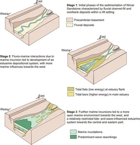
Fig.16 Schematic 3D palaeogeographic model of the deposition of Nimar Sandstone Formation in the Narmada rift basin
The lowstand stratal package is overlain by the topmost fining-up hemicycle (U-F) with a retrogradational stratal stacking pattern formed by predominantly tideand wave-produced sediments of FA-4 and FA-5(Figs. 10, 11, 12 and 13). The prevalence of wave- and tide-controlled sedimentation with a low or rare signature of fluvial deposition suggests a coastal onlapping,which covered the earlier fluvial (HAST and LAST) and the fluvio-tidal (LST) deposits. A clear shift from pure fluvial depositional processes to open coastal depositional systems in different parts of the basin (Figs. 10,11, 12 and 13) undoubtedly attests to a landward shift of the shoreline. Thus,the fining-up retrogradational stratal package in U-F represents a transgressive systems tract(TST). Minor variations in the stacking pattern within this TST in different areas are caused by varying water energy in different parts of the basin during the marine flooding event, which led to varied depositions from (i)wave-reworked shoreface sands with marine bivalves,gastropods, and trace fossils in the western part (more open marine), to (ii) finer-grained clastics with abundant Ostrea, Turritella and trace fossils (Thalassinoides) of marginal marine affinity, characteristic of brackish water conditions in the eastern part (landward, sheltered estuary-like). The contact with the overlying Nodular Limestone Formation (Fig. 14) is considered as the end of transgression documented by the Nimar Sandstone Formation succession;however,demarcating any definite surface (e.g., the maximum flooding surface) is not feasible due to the relatively poor preservation of features in outcrops and restricted lateral continuity of features.
5.2 Sequence stratigraphic architecture
In absence of absolute age data of the Nimar Sandstone Formation (as mentioned in Table 2), the chronological attributes of bounding surfaces and major events become problematic in the study area. The major transgressive cycle encompassing the entire Nimar Sandstone Formation succession definitely indicates a transgression.Since the lower contact of the Nimar Sandstone Formation is fault-bound, the actual starting age of the deposition is difficult to determine. The top boundary with the overlying Nodular Limestone Formation is conformable and indicates inland continuation of marine sedimentation. Thus, we may consider the major fining-up cycle in the Nimar Sandstone Formation as part of a major, continuous transgressive event. So, assigning the proper status of this major transgressive cycle in terms of sequence elements (sequence or systems tracts) is tricky and is avoided here.
The high-frequency T-R cycles resemble different systems tracts, viz., L-C as HAST, L-F as LAST, U-C as LST,and U-F as TST,depending on characteristic stratal stacking patterns with assemblages of different facies associations (discussed earlier). Nature of the transition between the HAST and the LAST is gradual, rendering no definite bounding surface between them in field exposures. The changeover from the LAST and the overlying LST is commonly marked by initiation of tidal influence within the channel deposits and the progradation of these channel systems over the underlying overbank deposits. Sharp channel bases are locally identified in individual exposures, but poor preservation quality with lack of lateral continuity restricts the identification of a definite bounding surface between the LAST and the LST. Similarly, the changeover from LST to the topmost TST is not marked by any distinct surface such as the maximum regressive surface (MRS) and is mostly identified by the gradual change in the stratal stacking pattern from coarsening-up (U-C) to fining-up (U-F).The facies architecture near the upper boundary of the TST is not uniform throughout the sections and,in turn,makes it difficult to demarcate a definite terminating surface such as the maximum flooding surface (MFS).However,the Nodular Limestone Formation overlies this topmost TST throughout the study area, and definitely indicates the culmination of the transgressive event within the Nimar Sandstone Formation succession. Such variations in the facies architecture, causing difficulty in lateral correlation and identification of bounding surfaces of the sequence/systems tracts are due to the complex sedimentary facies distribution in the evolving fluvio-estuarine system within the riftogenic basin.
5.3 Palaeogeography
The Late Cretaceous global sea-level rise led to significant marine transgressions that affected part of western and central India (Acharya and Lahiri 1991; Singh and Mishra 2000; Desai 2013). This led to seawater inundation of large areas of central Indian land, resulting in a shift in depositional conditions from pure continental to marine/marginal marine. One such example of marine transgressions and change in depositional conditions is well recorded in the Upper Cretaceous Bagh Group, preserved within the Narmada rift basin.
Analysis of the Nimar Sandstone Formation succession in the light of transgressive-regressive cycles reveals a major transgressive event affecting the upper part of the succession. The initial fluvial system depicts an amalgamation of channel and overbank deposits under lowto-high accommodation conditions, mostly controlled by changing river equilibrium profile due to tectonic subsidence and varied sediment supply. This caused thick accumulation of channel-fill and overbank deposits in the lower part of the Nimar Sandstone Formation. An east-west flowing river system is reconstructed, with coarse sediments dominating in the east and fine sediments in the west. In the western part of the basin, the fluvial system was affected by tidal intermixing, indicating a significant marine encroachment and fluvio-tidal interference (Fig. 16). The effect of tidal influence is more pronounced in the upper transgressive hemicycle(U-C), which records prevalent drowning of the underlying fluvial system. The effect of this drowning was more dominant in the western part and less in the eastern part, indicating that the marine encroachment took place from west to east with the development of a tideinfluenced estuarine system in the west changing to more fluvial-dominated bay-head delta systems in the east. Overall facies architecture indicates that an initial fluvial depositional setting was engulfed by the development of a tide-influenced estuarine system (Fig. 16),where three distinct depositional zones can be deciphered, namely,
i) a fluvio-tidal interactive inner estuary zone, developed in the eastern part of the basin, characterized by the tide-reworked thick channel-fill and overbank deposits,
ii) a tide-dominated central estuary zone, developed in the central part of the basin, characterized by development of tidal sand bars and sand- and mud-flats based on the extent of inundations, mutual strength of tidal and fluvial systems, and type of net accommodation created, and.
iii) a tidal- and wave-dominated outer estuary part, developed in the western part of the basin, characterized by more open marine tide- and wave-reworked sediments of shore environments.
Successive stacking of high-frequency transgressiveregressive cycles was caused by fluctuations in the base level in response to the Cenomanian sea-level rise along with net sedimentation controlled by the basinal subsidence caused by reactivation of basin marginal faults in the Narmada rift basin (Jha et al.2017). During the late stage of the transgression,outer estuarine open marine conditions encroached further landwards inundating the entire basin, which led to shallow, low-energy conditions with deposition of the Nodular Limestone Formation as an apron covering the underlying Nimar Sandstone Formation.Thus, the shift in depositional conditions from fluvialdominated to a transgressive tidal- to wave-influenced estuarine system attests to significant tectonosedimentary changes accompanied by prolonged events of marine transgressions in the Narmada rift basin during the Late Cretaceous.
6 Conclusions
The detailed facies analysis and sequence stratigraphic analysis of the Cenomanian Nimar Sandstone Formation helps to sort out the facies architecture in the fluviomarine interactive estuarine system. Based on the present study, we can frame the following conclusive remarks:
1) Detailed facies analysis records deposition of the lower part of the succession in a fluvial setting,which changed up-section into a transgressive fluvio-marine estuarine setting with: (i) a fluvialdominated inner estuary zone, with the transition from fluvial to tide-affected fluvial deposits, (ii) a transitional central estuary zone consisting of transitional fluvio-tidal channels and tidal flats, associated with tidal channels and bars, and (iii) a wavedominated shallow-marine outer estuary zone. This evolution is time-transgressive with a gradual shift of different depositional conditions in space and time.
2) Reactivation of basin-marginal faults during the Cenomanian time caused sequential subsidence of the land part within the Indian Plate, which enhanced the effective landward incursion of seawater due to the Cenomanian sea-level rise.
3) The major transgression is attributed to the Cenomanian global eustatic rise, whereas the highfrequency T-R cycles indicate systematic variation in net sediment supply, change in accommodation space related to tectonic subsidence, and base level fluctuations, resulting in characteristic stratal stacking patterns.
4) The proposed tectono-sedimentary model based on the integrated sedimentological-sequence-stratigraphic study helps to reconstruct the palaeogeography in central India during the Late Cretaceous.Such a palaeogeographic model can be applied to similar transgressive fluvio-marine sedimentary successions formed in passive margin rift basins, where transgression is controlled by both eustatic changes and tectonic subsidence.
Abbreviations
HAST: High-amalgamation systems tract; IHS: Inclined heterolithic strata;LAST: Low-amalgamation systems tract; LST: Lowstand systems tract;MFS: Maximum flooding surface; MRS: Maximum regressive surface;SSDS: Soft-sediment deformation structures; T-R cycles: Transgressiveregressive cycles;TST: Transgressive systems tract
Acknowledgements
The authors like to thank IIT Roorkee for providing the research facilities. The authors gratefully acknowledge the thorough and critical reviews by two anonymous reviewers and the constructive comments of the editors of JoP.
Authors’contributions
BB participated in the field work, identified and interpreted the primary sedimentary structures and the facies types, conceptualized the problem,completed the correlation of facies and facies associations in 2-D and 3-D,prepared the sequence stratigraphic models and drafted the manuscript. SJ has carried out the detailed descriptions of facies types, prepared the logs,participated in the field work and drafted the manuscript. PM has participated in the field, assisted in acquiring data and in lab analysis and drafted the manuscript. All the authors have read and approved the final manuscript.
Funding
Authors are thankful to the Ministry of Earth Sciences, Government of India,for financial support in the form of Extra-Mural Research Project (Ref. No.MoES/P.O.(Geo)/142/2017).
Availability of data and materials
The authors declare that the materials are available in open field area to be accessed by anyone. All data are collected by the authors themselves through fieldwork followed by laboratory analysis, and nothing has been supplied by any person or organization.
Competing interests
The authors declare that they have no competing interests. The authors alone are responsible for the content and writing of this article.
Author details
1Department of Earth Sciences, Indian Institute of Technology, Roorkee 247667, India.2Geological Survey of India, Jabalpur 482003, India.
Received: 6 March 2020 Accepted: 16 October 2020

 Journal of Palaeogeography2021年1期
- Journal of Palaeogeography的其它文章
- Labechia carbonaria Smith 1932 in the Early Carboniferous of England;affinity,palaeogeographic position and implications for the geological history of stromatoporoid-type sponges
- Bioturbation of Thalassinoides from the Lower Cambrian Zhushadong Formation of Dengfeng area,Henan Province,North China
- Palaeobotanical and biomarker evidence for Early Permian(Artinskian)wildfire in the Rajmahal Basin,India
- Winners of the Awards for excellent papers published in Journal of Palaeogeography during 2012-2018 (October 28, 2020)
- A combined geophysical and lithological study on eruptive history and Quaternary lacustrine stratigraphy of a maar in Leizhou Peninsula,China
- Characteristics and origin of a new type of polyhalite potassium ore in the Lower Triassic Jialingjiang Formation,Puguang area,northeastern Sichuan Basin,SW China