遥感植被指数与植物多样性的相关性及空间分布特征研究——以海口市主城区为例
2021-06-10 09:01:47何荣晓雷金睿杨帆
广西植物
2021年3期
何荣晓 雷金睿 杨帆
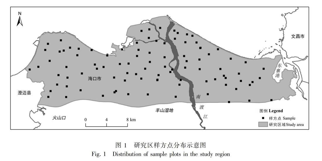

摘 要:植物多样性监测是开展物种保护与植被景观规划的重要基础,对实施生物多样性的优先区域保护具有重要意义。该文以海口市主城区为例,利用Landsat 8遥感数据与样方实测数据分析了植被指数与植物多样性指数之间的相关性,根据相关性分析结果构建植物多样性遥感监测数学模型,并筛选出最优模型用于监测研究区植物多样性的空间分布状况。结果表明:Shannon-Wiener多样性指数、Simpson多样性指数和Pielou均匀度指数与MSAVI植被指数相关系数最高,呈显著相关性(P<0.01)。通过一元线性数学回归模型得到的海口市植物多样性空间分布特征与实际情况相符,植物多样性水平较高的区域主要分布在火山口、东寨港和羊山湿地一带,且具有明显的空间自相关性。根据研究结果建议继续实施严格的保护措施,加强生态修复与保护工程,提高植被覆盖率和生物多样性水平。
关键词: 生物多样性, 植被指数, 植被覆盖率, 空间自相关, 遥感监测
中图分类号:Q948.1
文献标识码:A
文章编号:1000-3142(2021)03-0351-11
收稿日期:2019-07-10
基金項目:海南省自然科学基金(318QN195);海南大学科研启动基金(KYQD[ZR]1839, KYQD[ZR]1821) [Supported by Hainan Natural Science Foundation (318QN195); Research Start-up Fund of Hainan University (KYQD[ZR]1839, KYQD[ZR]1821)]。
作者简介: 何荣晓(1987-),博士,讲师,研究方向为园林植物景观设计,(E-mail) rx.he@hainanu.edu.cn。
通信作者:雷金睿,硕士,助理研究员,研究方向为城市园林植物与景观评价,(E-mail)raykingre@163.com。
Correlation and spatial distribution characteristics of remote sensing vegetation index and plant diversity—A case study of main urban area of Haikou City
HE Rongxiao1,2, LEI Jinrui3*, YANG Fan1,2
( 1. College of Forestry, Hainan University, Haikou 570228, China; 2. Hainan Biological Key Laboratory for Germplasm Resources of Tropical Special Ornamental Plants, Haikou 570228, China; 3. Hainan Academy of Forestry/Haikou Wetland
Protection Engineering Technology Research and Development Center, Haikou 571100, China )
Abstract:Plant diversity monitoring is an important basis for species conservation and vegetation landscape planning, and it is of great significance for the implementation of priority area protection for biodiversity. Taking the main urban area of Haikou City as an example, we analyzed the correlation between vegetation index and the plant diversity index by applying remote sensing data from Landsat 8 and measured data in site, and then built the mathematical model of remote sensing monitoring for plant diversity and screened out the optimal model that is used to monitoring the spatial distribution of plant diversity in the study region. The results were as follows: Shannon-Wiener diversity index, Simpson diversity index and Pielou evenness index had the highest correlation coefficient with MSAVI vegetation index, with significant correlation (P<0.01). The spatial distribution of plant diversity in Haikou acquired from the unitary linear regression model was consistent with the actual situation. The areas with higher plant diversities were mainly distributed in the volcanic crater, Dongzhai harbor and Yangshan wetland, which had obvious spatial self-correlation. According to results obtained from this research, continual implementation of strict conservation measures, enhancement of ecological restoration and conservation projects, and improvement of vegetation coverage and biodiversity are recommended.
Key words: biodiversity, vegetation index, vegetation coverage, spatial self-correlation, remote sensing monitoring
生物多樣性是人类赖以生存的物质基础。随着全球范围内物种和栖息地的丧失,生物多样性破坏已严重威胁可持续发展和生态系统稳定性,成为生态学和地理学研究的热点问题(陈亮和王绪高,2008;胡海德等,2012)。近年来,随着遥感技术的快速发展,因其具备大尺度、长时间序列、多类型等优势而被广泛应用于土地利用变化(雷金睿等,2017)、生物量估测(张艳楠等,2012;王紫君等,2016)、环境监测(Koponen & Ullininen,2002;闫峰等,2006)、森林健康(Arekhi et al.,2017)等方面的研究,将遥感技术应用于生物多样性监测领域也是目前国际生物多样性研究的最新趋势,同时也是研究难点(徐文婷和吴炳方,2005;程乾等,2016;郭庆华等,2018;郭庆华和刘瑾,2018)。……
登录APP查看全文