
基于CloudSat资料的青藏高原云分布特征研究
2021-12-17 19:47:16鲍金丽
农业灾害研究
2021年8期
鲍金丽
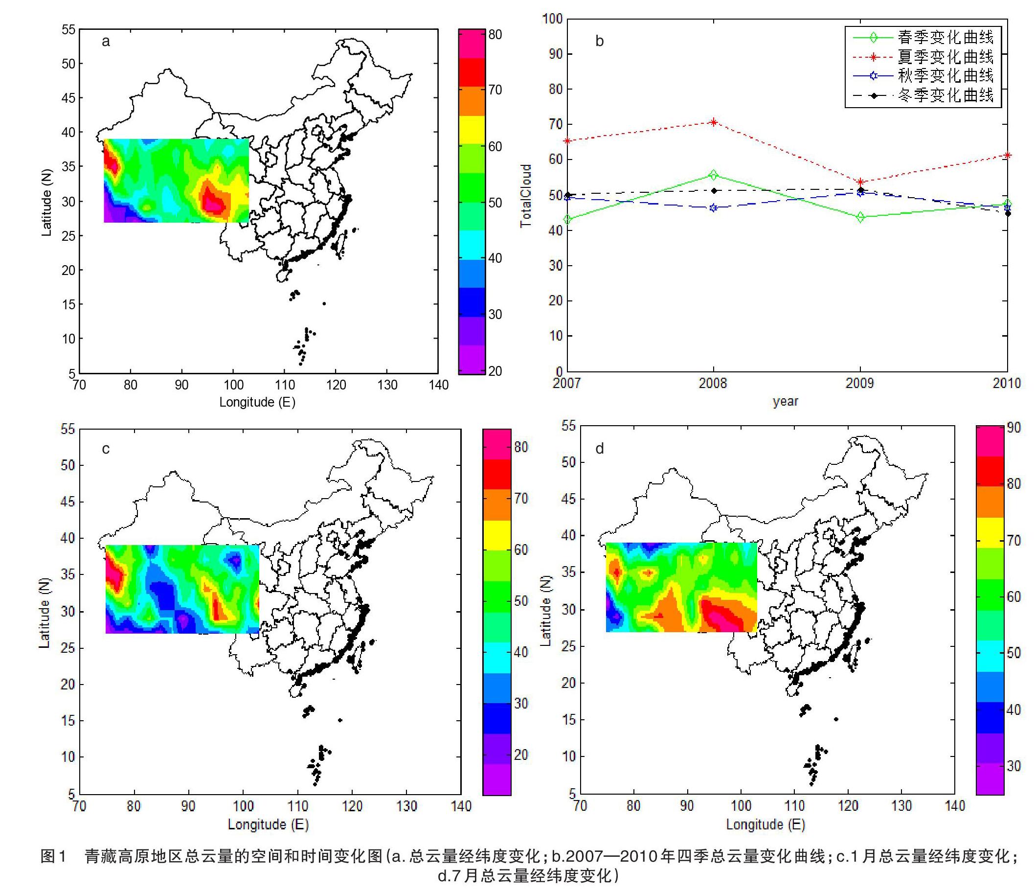
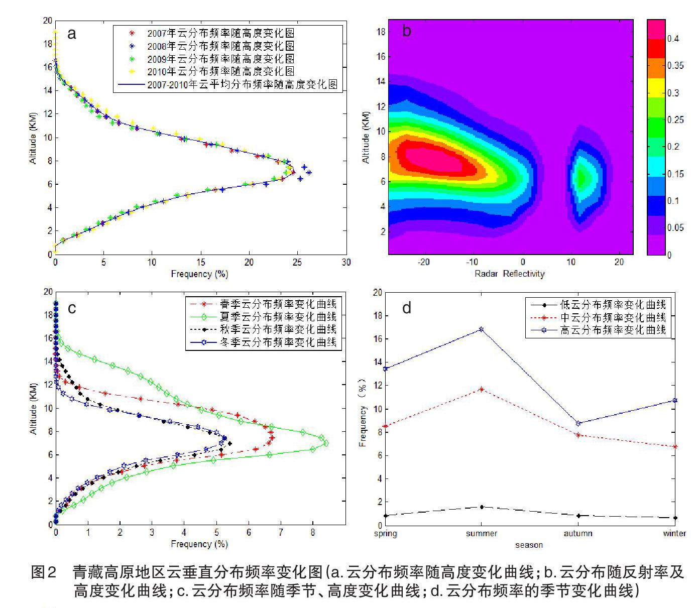
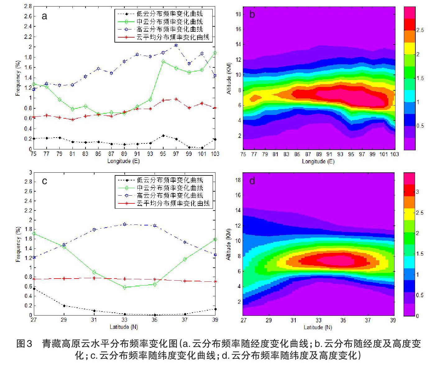
摘要 基于2007—2010年CloudSat卫星资料,本文分析了青藏高原云的水平分布及垂直结构分布特征,得出以下结论:(1)青藏高原地区夏季总云量明显多于冬季,且夏季总云量呈现出由东南向西北减少的分布趋势;(2)青藏高原地区云分布频率的垂直结构会随季节的变化而变化,夏季的云分布频率高于其他三个季节,最大云分布频率位于7 km左右的高空;(3)青藏高原地区东部云分布频率大于西部的云分布频率,不同高度层云分布频率变化趋势不同。
关键词 Cloudsat;2B-GEOPROF;总云量;云分布频率;云垂直结构
中图分类号:P426.5 文献标识码:B 文章编号:2095–3305(2021)08–0100–03
Study on Cloud Distribution Characteristics of The Tibetan Plateau Based on CloudSat Data
BAO Jin-li (Fei County Meteorological Bureau, Linyi, Shandong 273400)
Abstract Based on the CloudSat satellite data from 2007 to 2010, This passage analyzed the horizontal distribution and vertical structure distribution characteristics of the Tibetan plateau cloud. The following conclusions are drawn :(1) the total cloud amount over the Tibetan plateau in summer is significantly more than that in winter, and the total cloud amount decreases from southeast to northwest in summer. (2) The vertical structure of cloud distribution frequency over the Qinghai-Tibet Plateau changes with the seasons. The cloud distribution frequency in summer is higher than that in the other three seasons, and the maximum cloud distribution frequency is located at the altitude of about 7 km. (3) The cloud distribution frequency in the eastern part of the Qinghai-Tibet Plateau is larger than that in the western part, and the variation trend of cloud distribution frequency is different at different altitude levels.
Key words CloudSat; 2b-geoprof; Total cloud cover; Cloud distribution frequency; Cloud vertical structure
云在地氣系统中具有重要作用,确定云的分布特征对气候模式和气候监测非常有必要[1-2]。作为联系各种局地天气甚至全球气候各子系统的纽带,青藏高原的动力及热力作用对我国气候变化、灾害性天气的形成和发展及东亚大气环流甚至全球的气候都有着重要的影响[3-4]。运用统计的方法,利用CloudSat卫星观测数据,分析青藏高原地区的总云量及云分布频率特征进行分析,为研究青藏高原对天气和气候的影响提供参考。
1 资料与方法
使用2007—2010年二级云分类产品2B-GEOPROF和2B-GEOPROF_Lidar资料,对数据进行研究,确定扫描格点中是否存在云时使用的阈值方法如下:满足Radar_Refelectivity >= -30 dBZ且CPR_Cloud_mask >= 20或Radar_Refelectivity >= -30 dBZ且CPR_Cloud_mask <= 20,CloudFraction >= 99%时,就认为有云的存在,否则不存在云。
采用归一化等频率高度图的思想(Luo et al.2009)进行数据的统计处理,这种方法可以有效弥补早期提出的等频率高度图(Yuter and Houze,1995)的不足。
2 结果分析
2.1 青藏高原总云量的空……
登录APP查看全文
