
典型作物种植结构遥感提取
2021-12-17 20:17:03李鑫杨卢赫宇
农业灾害研究
2021年8期
李鑫杨 卢赫宇
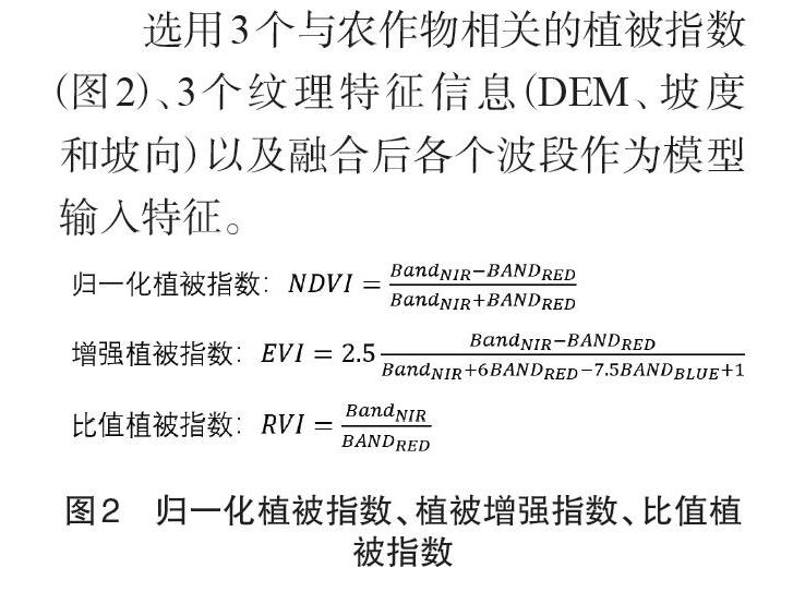
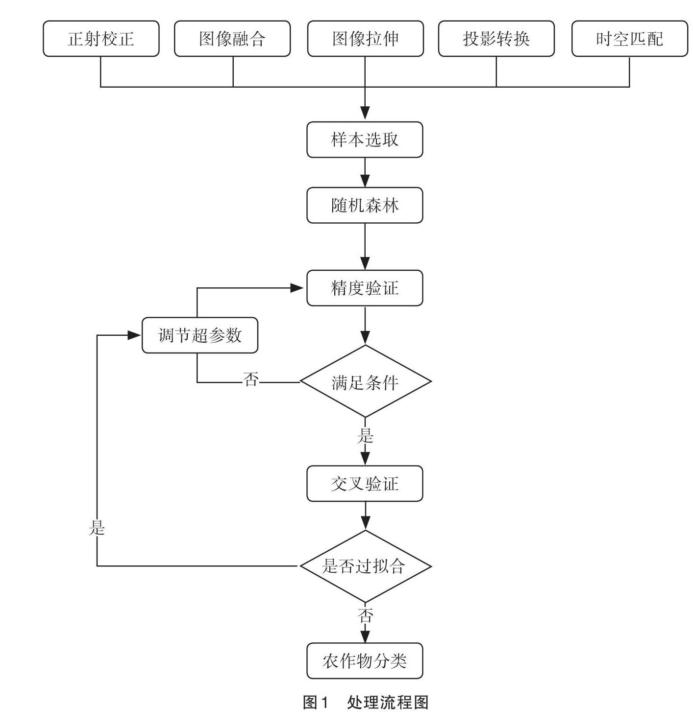
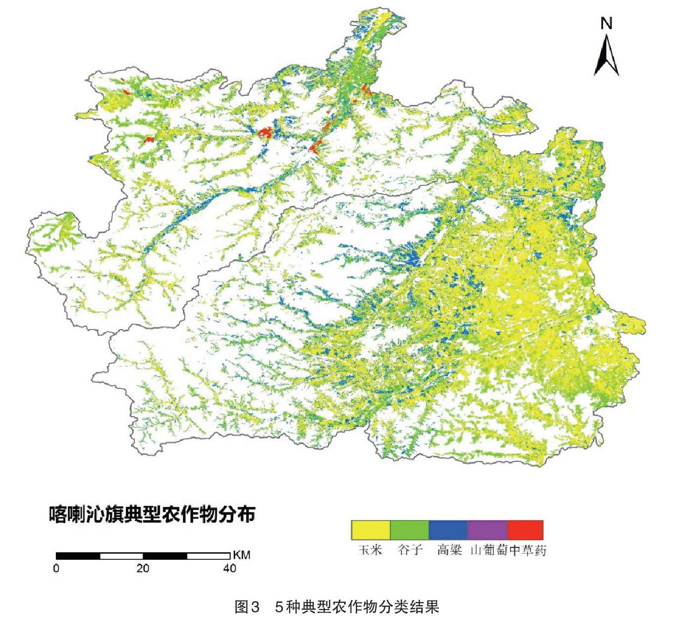
摘要 基于遥感的种植结构提取对农业资源调查、作物面积监测及产量估算、农作物灾害预警和灾后评估具有重要意义。本文根据高分一号和高分六号的数据,选用3个与农作物相关的植被指数(NDVI、EVI、RVI),3个纹理特征信息(DEM、坡度、坡向)以及融合后各个波段作为模型输入特征,研究基于高分辨率率影像数据的农作物分类。结果表明:西北部农作物主要为玉米,中部主要为谷子,东南部地区以玉米为主,其次为高粱和谷子;红边波段705和红边波段745均对农作物的识别和分类具有一定的作用。
关键词 遥感;农作物分类;种植结构;高分一/六号
中图分类号:P407 文献标识码:B 文章编号:2095–3305(2021)08–0142–02
Extraction of Typical Crop Structure Based on Remote Sensing
—A Case Study of Ningch-eng and Kalaqin County, Chifeng
LI Xin-yang et al (Weather Bureau of Chifeng, Chifeng, Inner mongolia 024000)
Abstract The extraction of planting structure based on remote sensing have great significance for agricultural resource investigation, crop area monitoring and yield estimation, crop disaster warning and post-disaster assessment. The article used the data of GF-1 and GF-6, chose 3 vegetation indices (NDVI, EVI, RVI) related to crops, 3 texture feature information (DEM, slope, aspect), and bands after fusing are selected as models, researched the crop classification based on high-resolution image data. The results of crop distribution showed that corn was mainly distributed in the northwest, millet was mainly distributed in the middle, corn was mainly distributed in the southeast, followed by sorghum and millet; both red edge band 705 and red edge band 745 can improve crop recognition and classification.
Key words Remote Sensing; Crop Clas-sification; Planting Structure; GF-1/GF-6
農作物种植结构是土地利用在农业生产上的表现形式[1]。传统农作物的类型、种植面积以及大致范围信息的获取以统计上报和抽样调查为主,但统计方法存在缺乏空间分布、主观性强、误差大和费力耗时等问题。农作物种植结构遥感提取主要基于不同类型农作物在遥感数据上呈现的光谱、时间和空间特征的差异,并且农作物光谱特性的时空效应存在遥感全过程[2]。遥感技术作为新型对地观测技术,因具有宏观性、综合性和动态性的特点,成为获取区域农作物布局和组成的重要途径[3]。快速、准确、客观地获取作物种植信息、科学地评估作物空间分布,对保障粮食生产安全具有重要意义,有助于合理优化种植结构、提升粮食生产效率和产量。
1 数据与方法
目前,国内外农作物种植结构提取使用的遥感影像包括以MODIS为代表的低分辨率影像、以Landsat TM/ETM+为代表的中等分辨率影像、以Sentinel、GF和QuickBird为主的高分辨率影像。……
登录APP查看全文
