
Seismic Characteristics and Hydrocarbon Accumulation Associated with Mud Diapir Structures in a Superimposed Basin in the Southern South China Sea Margin
2022-08-17 05:38QIANXingZHANGLiWUShiguoSUNZhongyuLEIZhenyuandLUOShuaibing
QIAN Xing, ZHANG Li, WU Shiguo, SUN Zhongyu, LEI Zhenyu, and LUO Shuaibing
Seismic Characteristics and Hydrocarbon Accumulation Associated with Mud Diapir Structures in a Superimposed Basin in the Southern South China Sea Margin
QIAN Xing1), 2), ZHANG Li2), WU Shiguo3), 4), 5), *, SUN Zhongyu3), LEI Zhenyu2), and LUO Shuaibing2)
1),511458,2),,510075,3),,,572000,4),519000,5),100049,
Mud diapirs are significant structures often associated with hydrocarbon migration and accumulation as well as gas hydrate formation in sedimentary basins. A total of 30 mud diapirs were observed in the northwestern Zengmu Basin in the southern South China Sea based on 2D multichannel seismic data. The structures are distributed along an NW-SE trend near the shelf break of the Kangxi depression in the Zengmu Basin. The mud diapirs were divided into the following according to their vertical shapes, intrusion heights, and effusive activities: tortoise, piercing, and nozzle types, which represent different evolutionary stages of diapirism. The mud diapirs in the study area suggest that the driving forces behind the mud diapirs considerably exceed the rock rupture limit of the overlying strata. Diapir formation can be divided into two steps: the accommodation of a large amount of mud in the Zengmu Basin and the movement of plastic mud induced by gravity-driven flow and regional tectonic compression. Combining seismic interpretations with analyses of the regional geology and tectonic subsidence, the current study proposes that rapid subsidence in the Kangxi depression sufficiently accommodated the vast amount of sediments deposited since the Middle Miocene, which provided favorable conditions for the growth of mud diapirs. Furthermore, the N-S directional stress field in the Zengmu Basin and the gravity slide northward along the southern slope of the depressionfurther facilitated the development of mud diapirs since the late Miocene. The mud diapirs in the southern South China Sea margins were accompanied by the accumulation and release of overpressured fluid.
mud diapir; genetic mechanism; gravitational slide; Zengmu Basin; South China Sea
1 Introduction
Mud diapirs are intrusive structures formed by highly plastic uncompacted shales with low density in the deep crust that arch into or pierce overlying strata driven by geologic stress. They are characterized by the slow upwardmigration of a large amount of clay-rich sediments and fluiddischarges (Hovland and Curzi, 1989; Dimitrov, 2002; Kopf, 2002). If the liquefied clay continues to invade and penetrate the seafloor along the ‘dominant channel’, then a mud volcano will form. Mud volcanoes are the product of the final developmental stage of submarine mud diapirs because they have similar genetic mechanisms and evolutionary characteristics (Milkov., 2003; Pinheiro., 2003; Normile, 2008).
Mud diapirs are extensively distributed worldwide in avariety of tectonic settings. Muds usually form at convergent margins, including in the Mediterranean Sea (Camerlenghi., 1995; Limonov., 1996; Robertson., 1996; Kopf., 1998), the Nankai Trough (Kobayashi., 1992; Morita., 2004), and Barbados (Henry., 1996; Lance., 1998; Sumner and Westbrook, 2001). However, mud diapir structures have also been observed on passive margins, including the Norwegian Sea (Hovland,1998), offshore Nigeria (Graue, 2000),and the Gulf of Me- xico (Neurauter and Roberts, 1994; Roelofse., 2019).
Studies have shown that more than 90% of the muddy effluent gas worldwide comes from underground oil and gas reservoirs (Ginsburg., 1999). Mud diapirs may have spatial and genetic links with oil and gas fields and are important clues for hydrocarbon and gas hydrate exploration (Lee., 1994; Ginsburg., 1999; Dimitrov, 2002; Milkov., 2003;Etiope., 2009). At present, mud diapirs and related structures have been extensively observed in the sedimentary basins of the South China Sea (SCS). They are widely distributed in the Zhongjiannan (Bai., 2014; Chen., 2015), Pearl Mouth (Wang., 2006; Yan., 2017), and Taixinan basins (Chiu., 2006; Chen., 2014) located on the passive margin in the northern SCS. An industrial gas field was discovered in the shallow layer of the Huangliu formation in the central mud diapir structural zone of the Yinggehai Basin and the Baiyun Sag of the Pearl River Mouth Basin (He., 1994; Wang and Huang, 2008). Gas hydrate re- servoirs associated with mud diapirs have also been observed throughout the northern SCS slope (Sha., 2005; Wang., 2010). These mud diapir structures are potential prospects for oil and gas exploration.
The mud diapir structures along the southern SCS margin have not been thoroughly studied. The Zengmu Basin is an important petroliferous basin along the southern SCS margin (Fig.1). The collision and uplift that occurred between the Nansha Block and the Borneo Orogenic Belt resulted in a multi-phased basin evolution that included rifting during the late Cretaceous–Eocene and peripheral foreland basin development since the late Eocene (Madon, 1999; Madon., 2013; Dong., 2017). Previous stu- dies have also suggested that mud diapirs have been observed in the Zengmu Basin; however, these studies were focused on regional geology (Jiang., 1994; Mat-Zin and Tucker, 1999; Madon., 2013) and petroleum basinanalysis (Liu and Jin, 1997; Hasiah, 1999; Yao., 2008;Hakimi., 2013; Togunwa., 2015).
This study presents the characteristics and distribution of mud diapirs in the Zengmu Basin based on newly acquired and reprocessed multichannel seismic profiles. Furthermore, their controlling factors are discussed, and potential driving mechanisms for mud diapir formation in this region are proposed. The underlying motivation of this study is to provide guidance and references for the exploration and development of mud diapir-related oil and gas reservoirs in this area of the SCS.
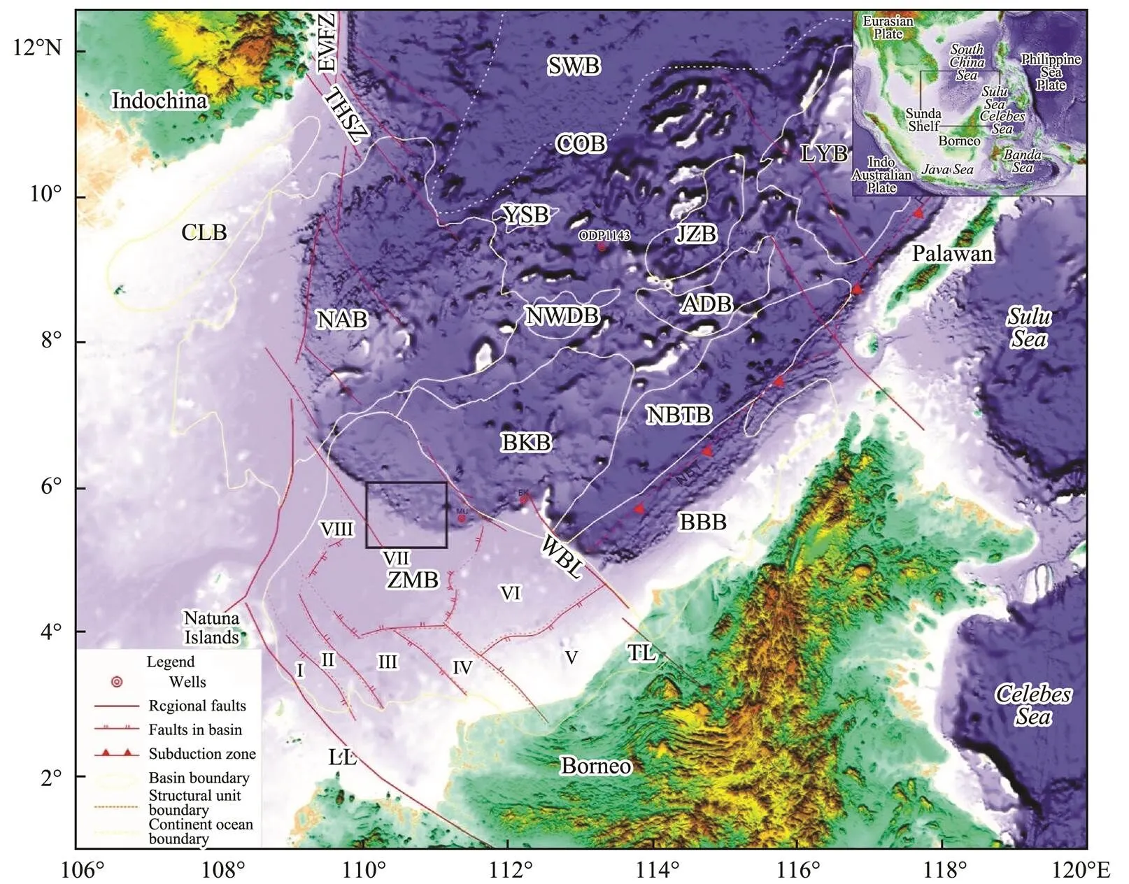
Fig.1 Geological structures and sedimentary basins on the southwestern margin of the South China Sea. The upper right inset shows the regional tectonic location. The black box indicates the study area. ZMB, Zengmu Basin; BKB, Beikang Basin; NAB, Nanan Basin; CLB, Cuu Long Basin; YSB, Yongshu Basin; NWDB, Nanweidong Basin; JZB, Jiuzang Basin; ADB, Andu Basin; LYB, Liyue Basin; BBB, Baram Balabec Basin; NBT, NW Borneo Trough Basin; NBT, NW Borneo Trough; EVFZ, east Vietnam fault zone; THSZ, Tua Hoa shear zone; WBL, west Baram line; TL, Tinjar line; LL, Lupar line; SWB, southwest sub-basin; COB, continent ocean boundary; I, Suokang depression; II, Lana uplift; III, Tatao Graben; IV, west Balingian uplift; V: east Balingian depression; VI, Nankang platform; VII, Kangxi depression; VIII, west slope. The tectonic boundaries refer to Wu (1997), Morley (2016), and Gao et al. (2015).
2 Geologic Setting
The SCS is located southeast of the Eurasian Plate and is influenced by the interactions of the Eurasian, Indo-Aus- tralian, and Pacific Plates. The Cenozoic ocean basin expanded from 32 to 16Myr (Talor and Hayes, 1980; Hall, 1997; Cullen., 2010; Franke., 2014; Li., 2014; Lin., 2014; Sun., 2019). Therefore, the southern SCS margin contains some massifs from the South China Block, including Liyue Bank and Dangerous Ground (Hall, 1998; Sun., 2011; Franke., 2014). Moreover, a paleo-SCS could exist between the rifting South China Block and the Borneo Orogenic Belt, which have been colliding since the Eocene. The southern margin of the SCS experiences rifting, subduction, and collision- related processes (Hutchison, 2004).
The Zengmu Basin is located on the southwestern part of the SCS margin. To the west, this basin is bordered by the Natuna uplift, which is bounded by the Lupar fault. This area has been suggested to be the western boundary of the SCS margin (Dong., 2017). To the east, the Zengmu Basin connects the Brunei-Saba Basin and the Nansha uplift with the Tingjia fault. The northern and southern boun- daries of the margin have not yet been clearly defined. TheNanan Basin is located to the north, separated by one fore- bulge uplift, while the Sarawak Orogenic Belt is located to the south, limited by the Lupar fault. The internal structural framework of the Zengmu Basin can be divided into the following eight structural units: the Suokang depression, Lana uplift, western slope, Tatao Base, Kangxi depression, west Bahrain uplift, Dongbalinjian depression, and Nankang Terrace (Fig.1).
The basement of the Zengmu Basin comprises three lithologies (Zhou., 2011). The highly deformed and weakly metamorphosed Eocene Rajang group is distributed in the southern part of the Zengmu Basin. Folded Paleocene–Eocene phyllites occur in the Lana uplift southwest of the basin. Mesozoic granodiorites and Eocene volcanic agglomerates have been observed in the northern part of the basin. The Zengmu Basin is spatially located between three herringbone fractures (Wanan, Tinjar, and Lupar) with strike-slip properties (Wu, 1997), and faults are regularly distributed throughout the basin. NW striking faults are mostly distributed in the south and have torsional properties that control the boundaries of the basins and tectonic units. NW and approximately E-W, striking faults are main- ly developed in the northeastern part of the basin and are generally slightly convex to the south (Wu, 1997; Madon, 1999; Qiu., 2005; Zhou., 2011).
The Zengmu Basin has undergone three tectonic stages: rifting, foreland development, and development into an intracratonic basin. Accordingly, the sedimentary environ- ment in the Zengmu Basin has transitioned from a terrestrial coastal plain to a shallow marine environment and then to a deep marine environment (Jiang., 1994; Ma- don., 2013). The seismic sequences in the Zengmu Basin can be divided into seven seismic units separated by eight reflectors (Figs.2 and 3). Unit SQ I represents the Eocene rifting sequence, which comprises delta, lacustrine, and fluvial facies. Unit SQ II may be an Oligocene fore- land sequence comprising marine and coastal plain facies. Unit SQ III belongs to the early Miocene foreland sequence, comprising coastal, shallow marine sand, and carbonate facies. Unit SQ IV is the sediment that was deposited in the middle Miocene foreland basin, which includes large amounts of hemipelagic sediments. A sequence of submarine delta fronts, deep-water channel systems, and slide deposits has been observed in the shelf break and slope. Unit SQ V is the late Miocene foreland sequence, which is the same as the middle Miocene sequence. Unit SQ VI comprises terrigenous sediments. The youngest Unit SQ VII comprises widely distributed relict shallow shelf sediments, hemipelagic sediments, and gravity flow deposits in the northern part of the basin (Fig.3). Analysis of the seismic profile shows that this area has been filled by massive sediments and may be the depocenter of the northern Zengmu Basin because the sediment has been more than 12km thick since the early Miocene. This condition indicates that the depocenter of the Zengmu Basin migrated from south to north due to tectonic motion along the right- lateral strike-slip Tinjar Fault (Zhong., 1995; Dong., 2017).

Fig.2 Generalized stratigraphic column of the Zengmu Basin. The global sea-level curve is based on Haq et al. (1986); chronostratigraphy is according to Zhou et al. (2011); the depositional environment is according to Madon et al. (2013); the tectonic events and evolutionary stages of the basin refer to Lei et al. (2015), Madon et al. (2013), and Morley (2016).

Fig.3 Seismic profile L1 (L1-1, L1-2, and L1-3) across the Zengmu Basin on the Southern South China Sea margin. (a) Multichannel seismic reflection line L1. (b) Interpreted section. Seismic section L1 across the Tatao Graben and Kangxi depression, extending from south to north in the Zengmu Basin. L1 is connected by three seismic sections. The gray area in (a) indicates the absence of recorded data beneath 7–9s. The black vertical line in (a) indicates the joining of two seismic profiles. Eight seismic reflectors were interpreted (b), which included reflectors T1, T2, T3, T1 3, T4, T5, and Tg. The stratigraphic framework is shown in Fig.1. The black solid box in (b) shows the gravitational slides caused by the rapid accumulation of a large amount of sediments on the background extensional faults near the slope break (location of the line in Fig.4).
3 Data and Methods
The 2D seismic data, which were collected using R/Vanded from the Guangzhou Marine Geological Survey (GMGS). The seismic lines covered the shelf and slope areas of the Zengmu Basin. The seismic survey grid extended appro- ximately 8km×16km. The main and crossing lines respectively extended to the NE-SW and NW-SE. All the lines were scanned in this study to illustrate the distribution of mud volcanoes.
The acquisition parameters of the survey lines are listedin Table 1. The seismic data in 2018 were reprocessed using new technical methods to determine the characteristics of the mud diapir structures in the study area. Simultaneous elimination of double-side virtual reflection bootstrapping, frequency shift q-tomography, and q-migration methods was realized in the data reprocessing. Seismic data pre-stack processing mainly included amplitude compensation, frequency division denoizing, curve domain noise suppression, Radon domain linear noise suppression, surface-related multiple elimination, deconvolution processing, high-resolution Radon transform multiple suppression, simultaneous elimination of double-side virtual reflection bootstrapping, q-tomography, and q-migration. Following this pre-processing, stack noise reduction processing was conducted on the stack data, which then generated the pre- stack time migrated data with high imaging quality.
4 Results
4.1 Mud Diapir Identification, Distribution, and Type
Mud diapirs are characterized by transparent or disordered reflections due to the homogeneous lithology of the seismic section. They usually have low density and low- velocity characteristics. The strata on both sides of a mud diapir exhibit pull-up structures because of the vertical motion or piercing of the mud diapir. Thirty mud diapirs were identified in the Kangxi Depression of the Zengmu Basin using 2D multichannel seismic data (Table 2) based on theircharacteristics in seismic sections. Among the 30 mud dia-pirs identified, the minimum arching amplitude of the muddiapirs in the seismic profiles only had a 1.4s two-way tra- vel time (MD8), and the maximum amplitude was more than a 4s two-way travel time (MD11). Most of the mud diapirs had stopped upwelling and were covered by the over-lying sediments. Meanwhile, a few of the mud diapirs, such as MD2, MD15, and MD20, continued to intrude and pe- netrate the seafloor to form mud volcanoes. The mud diapirs also had a zonal distribution; they were distributed in an NW-SE trending region in the Kangxi depression (Fig.4). All the mud diapirs were located at water depths larger than 200m. Their widths varied from 1.7km to 7.8 km. The maximum length of a single mud diapir was approximately 23.91km (MD15), while the shortest was only 2.1km (MD26). The size of a single diapir varied from 3.1km2to 77.8km2, and the diapir region covered an area of nearly 3420km2.
The mud diapirs were categorized into the following three types based on their shapes, intrusion heights, and effusive activity: tortoise, piercing, and nozzle diapirs.

Table 1 Acquisition parameters of seismic surveys in the Zengmu Basin, southern SCS

Table 2 Types and characteristics of the mud diapirs in Kangxi Depression (Zengmu Basin, South China Sea)
1) Tortoise mud diapirs
The tortoise-type mud diapirs push the overlying strata upward and produce low amplitude deformation. Most of these diapirs did not pierce the overlying rock layers, indicating extremely weak upward effusive activity. This typeof diapir could also reflect the initial stage of diapir activity (Fig.5a). Few internal and surrounding faults in the overlying sedimentary sequences were associated with this typeof mud diapir. Anticline structures are also associated with the tortoise-type mud diapir, which could be favorable for oil and gas accumulation.
2) Piercing mud diapirs
Unlike the tortoise mud diapirs, piercing mud diapirs exhibited strong effusive activity and had great extents of intrusion into the overlying strata. This type of mud diapir is the result of further development of the tortoise diapir, resulting in the rupture and piercing of overlying strata. Thesurrounding sedimentary sequence is pulled upward by the arching of the mud diapir. The anticlinal uplift formed at the top of the mud diapir is often accompanied by many faults that divide the strata on top of the diapir into fault blocks of different sizes (Fig.5b).

Fig.4 Two way travel time contour map of the T2 reflector in the Kangxi depression. Arabic numerals 1 to 30 represent the mud diapir numbers. Gray solid lines represent the locations of the multichannel seismic reflection lines in each figure (the figure location in Fig.1).
3) Nozzle mud diapirs
Nozzle-type mud diapirs were characterized by a funnel-shaped spout. The formation mechanism is thought to originate when the pull-up force of the diapir substantially exceeds the rupture limit of the overlying strata, and large amounts of mud and fluid are then sprayed out of the seafloor. This material then cools and contracts afterward. The formation above the nozzle diapirs was characterized by a seismic push-down effect, which can be interpreted as reduced velocities caused by the fluid/gas-bearing diapir structure, producing a longer travel time than that in the surrounding rock (Figs.5c–f).
4.2 Associated Deformation Structures
Owing to the upwelling of the diapir core material, someassociated structures and phenomena developed around the diapir structures that are closely related to the mud diapir activity. A top fault is the most common structure associated with the mud diapirs. Figs.5a, b, and d show the development of several small braided faults on top of the diapir uplift area. These faults developed close together, had steep dips (mostly between 70˚ and 90˚), and cut into the top of the diapir despite their small offsets. The shape and combined style of these faults in the cross-section in- dicate that they are driven by the energy of the diapir material. The strata at the top of the diapir structure were passively uplifted under the influence of the rising and arching diapir material. Owing to the weakening of the active energy of the diapir, the upwarping gradually stopped in a later stage, resulting in subsidence of the strata and the formation of faults at the top of the diapir.
A strong reflection interface in seismic sections generally indicates the presence of a large difference in wave impedance between the upper and lower strata at the reflection interface. Mud diapirs transport large amounts of fluid during the intrusion process. The formation velocity decreases or increases significantly when the aforementioned fluids accumulate in the formation, resulting in an acoustic impedance difference with the surrounding rock (Figs.5b and d). The strong reflections on the tops of the diapirs may represent the upper interface of the upward migrating fluid in the diapir, which is attributed to fluid accumulation in the upper formation. The strong reflections on both sides of the diapirs are parallel to the sedimentary strata, which may be a direct indication of fluid migration along a layer with anomalous physical properties during vertical fluid migration.
The mud diapir vents have micro-recessed shapes, which are also known as ‘pockmarks’. Studies have shown that the formation of mud diapir vents is directly related to deep overpressured environments and diapir materials (Hovland and Curzi, 1989; Pilcher and Argent, 2007). As shown in Fig.5d, two strong seismic interfaces with a ‘V’ shape were identified at the top of the MD9 diapir, and an onlap boundary was observed between the upper and lower strata.The characteristics of seismic facies of the upper and lower strata in the ‘V’-shaped reflection interface varied, corresponding to different sedimentary environments before and after formation deposition. The two ‘V’-shaped reflection interfaces presented in Fig.5d indicate two strong eruptive events from this mud diapir. The mud diapir vent is a type of submarine bathymetry formed by the mud diapir material directly ejected from the seafloor. The energy weakened afterward, and the mud diapir was thus unable to support the overlying strata, which led to an eventual collapse of the overlying strata. The ‘V’-shaped vent formed by the collapse provides an accommodation space for the sediment deposits. The mud diapir vents are gradually fill- ed as the mud diapir activity steadily weakens and stops, and the geometry observed herein is eventually formed.

Fig.5 Structures and phenomena related to mud diapirs in the Zengmu Basin. The locations of the multichannel seismic reflection lines are shown in Fig.4.
Mud volcanoes are a type of modern geological structure formed by the vertical movement of diapir materials that pierce the overlying strata and erupt onto the seafloor. Figs.5c and e show the formation of two typical mud volcano structures due to the accumulation of argillaceous sediments that pierced the seabed. The structures are flattened or mounded on the surrounding seabed in the seismic sections. The black arrows in Figs.5c and e indicate the upward erosive and upwelling channels of the mud volcano, respectively. The mud that filled the channel lacks stratification and lithological interfaces. Thus, the seismic reflections are characterized by chaotic low-frequency re- flections that differ from the characteristic mud volcano seismic facies (lateral strata).
Gas chimneys are low-velocity gas-bearing zones that occur due to gas filling of fractured strata (Milkov, 2002; Cathles., 2010) and are common columnar fluid activity systems (Sun., 2014). Fig.5f shows the deve- lopment of a typical gas chimney structure on top of the diapir. The gas chimney structure exhibited vertical extension with a columnar seismic reflection pattern. Seismic anomaly reflection patterns related to gas chimneys, such as disordered reflections, blank reflections, weak amplitudes, and the reflection pull-down effect, were observed (Figs.5c, d). The upper layer of the mud diapir is often weakin an overpressured environment and easily forms hydraulic fracturing, which can generate a large number of fractures. Fluids (mainly gases) can migrate along with these highly permeable fractures. Therefore, the formation mecha- nism of gas chimney structures is proposed for accumulating gases in the fractured zone to explain the presence of a weak zone in the formation.
5 Discussion
5.1 Factors Controlling the Development of Mud Diapirs in the Zengmu Basin
Some geological factors, such as rapid deposition (Talukder., 2007; Anka., 2012), mineral dehydration (Moore and Vrolijk, 1992), hydrocarbon generation (Hovland and Curzi, 1989; Cartwright., 2007), earth- quakes, and tectonic activity (Milkov., 2003), have been shown to be closely related to the formation of mud diapirs.
The diapir material in the Kangxi depression comprises two shale-dominated formations corresponding to the two stages of foreland superimposed basin development. A considerable amount of Oligocene to early Miocene shale was deposited in the foreland basin during the late Eocene –early Miocene. The subsidence center of the Zengmu Basin migrated northward during the Oligocene and Mio- cene, which was triggered by the uplift of the Borneo Orogenic Belt. The Kangxi depression in the northwestern Zengmu Basin became the new depositional center at this time (Fig.6). A large prograding delta formed in the nor-thern part of the basin with the transport of debris by the Larang and Lupar rivers that originated from the Sarawak Orogenic Belt (Hutchison, 2004; Guo., 2006; Koša, 2015). A considerable part of the sediment continued to move forward over the shelf slope during the migration of the delta from inland to seaward due to deep-water gra- vity flows, which transported large amounts of sediment to the Kangxi depression. Fig.6 shows that seismic line L1 ex- tends N-S across the Tatao Graben in the Zengmu Basin and ends at the Kangxi depression in the north. Bathymetrically, line L1 gradually transitions from a shallow- water shelf area to a deep-water area. The seismic two-way travel time range covers the entire sequence of Cenozoic strata. However, the stratigraphic features of each period are different in each structural unit, which is the response of the depositional center migration over time. The Tatao Graben contains the following: the Paleocene–Miocene (Tg–T5) as a set of structural strata controlled by early active syngenetic faults with varying thicknesses and the upper Eocene–lower Miocene (T5–T1 3) as a set of wedge- shaped strata that gradually decrease in thickness from south to north and appear as a large set of prograding reflections in the seismic section. Findings from the surrounding dril- led wells (MU/BK) and seismic data suggest that the Kang- xi depression area has been in a bathyal-abyssal environment since the early Miocene. The argillaceous deposits domi- nated the former delta facies in the Kangxi depression during this period, and these sediments thereafter became the main source of materials for diapir activity in the study area.

Fig.6 Subsidence curves along seismic lines during different geologic periods in the Zengmu Basin. Red and blue solid lines respectively represent the total subsidence and tectonic subsidence rate curves.
The existing shelf-margin delta since the middle Miocene (T1 3) also provided sufficient shale sediments. The collision between the Nansha Block and the Borneo Orogenic Belt occurred at the end of the early Miocene. There- fore, the extension of the Nansha block stopped and the Sarawak Formation in the Borneo belt was uplifted. The unconformity interface T1 3 (16.5Myr) was formed in the Zengmu Basin, which is of considerable importance for the structural evolution of the basin (Hutchison, 2004; Ma- don., 2013; Yao., 2013). The peripheral foreland basin developed under geologic settings varying from active subsidence to thermal subsidence since the Miocene. Strike-slip reconstructions of the Tinjar fault in the middle–late Miocene and the regional subsidence that occurred after the end of the SCS submarine expansion have shown that the Zengmu block, as a sub-basin, has subsided continuously since the late Miocene (Zhong., 1995; Mat- Zin and Tucker, 1999).
Large-scale sedimentary formations in the Tatao Graben, which were characterized by a prograding pattern, have been identified with a gradually thickening seaward trend. The maximum thickness of the sedimentary strata is 10000m at the subsidence center in the northwestern part of the basin. The Kangxi depression is located in the northern part of the Tatao Graben, with a seismic two-way travel time (TWT) of only 9s, indicating that the rifting stage (Tg–T5) and the foreland basin stage (T5–T1 3) are buried too deeply to be interpreted. However, the structural analysis of the basin indicates that deposition is still controlled by early active extensional faults, and the stratigraphy shouldhave features similar to those of the Tatao Graben. The se- diment in the Kangxi depression has been significantly thicker than that in the Tatao Graben since the middle Mio- cene (T1 3). The thickness of the strata was up to 8s (TWT) in the seismic section. The thickness can be estimated as approximately 12km, assuming that the stratum velocity is 2500ms−1.
These highly plastic and fluid uncompacted mudstones have higher porosities and lower densities than normally compacted mudstones. Thus, tectonic stresses in later stages can easily trigger the squeezing of plastic mudstones into the overlying strata along weak zones or faults to form diapir structures.
As discussed above, the Zengmu Basin underwent rifting and foreland basin development during the Eocene. The foreland development and evolution were impacted by secondary tectonic movements of the Sarawak and Sabah orogenies, which were closely related to the expansion and subsidence of the SCS. The Luconia block in the northern part of the paleo-SCS moved southward and collided with the Borneo block along the Lupar fault during the late Eocene–early Oligocene. By contrast, the Nansha block, which split from the South China block, drifted southward and collided with the Borneo block along the Tinjar fault during the middle Miocene. Some researchers believe that the Borneo block once rotated clockwise (Ran- gin., 1990) or counterclockwise (Schmidtke., 1990;Fuller., 1999) due to the collision and strike-slip motion between the two stages and blocks.
In map view, the Luconia block (Fig.1), which develop- ed in conjunction with the northern side of the Borneo block, is located between the two strike-slip faults. The two strike-slip faults combine with the Wanan fault to form a large herringbone strike-slip fault system. The Luconia block must have rotated counterclockwise under the movement of this herringbone dextral fracture system. The strike-slip process manifested as compression of the Luconia block to the southwest during the late Eocene–Oligocene, and the convergence of the Luconia block with the Natuna uplift in the Sunda block resulted in the formation of the Lanauplift. The stress field changed to NW-SE compression and formed NE-trending folds in the east Balingjian depression in the southern part of the Zengmu Basin during the early Miocene. The regional compressive stresses of the Luconia block during the late Eocene–Oligocene and early Miocene generally produced favorable driving forces for the formation and development of mud diapirs in the Kangxi depression (Wu, 1997; Madon, 1999).
The Zengmu Basin has been relatively tectonically stable since the middle Miocene. Under the background geomorphological pattern of the Sunda shelf slope and the rapid subsidence of the Zengmu Basin, large amounts of fine-grained argillaceous sediments from the shelf area were transported across the shelf slope and were eventually rapidly deposited in the Kangxi depression, which is characterized by a set of parallel reflections in the seismic section (Figs.3 and 7). However, the rapidly accumulating deposits have not been consolidated or diagenetically altered, making them relatively flexible and ductile. Owing to the overburden gravity and bathymetry of the continental slope, the deposits tended to slide along the slope or earlier extensional faults toward the subsidence center, which eventually led to lateral compression of the sedimentary strata.
Fig.3c shows the location of listric faults along the margin of the shelf slope transition in the Kangxi depression. These NE-oriented faults are mainly characterized by curved fault plane geometries that tend to converge in the deep parts of the formation. Along the lower planes of the listric faults, the ductile mudstone layer moves upward and uplifts the overlying structure, producing several reverse faults (Fig.7). These reverse faults were observed in the middle Miocene sequence in the Kangxi depression. The driving force of the thrust was also generated by the stress effect of the mud strata extrusion.
5.2 Structural Evolution of Mud Diapirs
Previous studies have described the formation and evolution of mud diapirs in various settings. The development and evolution of the mud diapirs in the Zengmu Basin can be divided into three stages.
1) Plastic mudstone deposition
Since the middle Miocene, the Kangxi depression has undergone rapid subsidence and had high sedimentation rates (Figs.6a–d). Thick argillaceous sediments developedon the continental slope (Kangxi depression) in an abyssalsedimentary environment with an abundant provenance supply. These mudstones were rapidly deposited in the basin, and the pore water and gas in the mudstones were thereby rapidly buried without being sufficiently dispersed. The mudstone layer adjacent to the permeable layer was compacted and drained initially with increases in burial depth under the load of the overlying strata, and the permea-bility decreased to form a tight layer. This tight layer even-tually became an important barrier to the discharge of most of the pore water from the mudstone. The mudstone during this period was a pressure compartment in which the internal and external fluids belonged to different systems (Fig.8a). The volume of the mudstone compartment remained unchanged or only changed slightly with the further burial of the mudstones and continued deposition of overlying sediments due to the influence of the regional geothermal field, the dehydration and expansion of clay minerals, and the conversion of organic matter to oil and gas (Osborne and Swarbrick, 1997; Lahann, 2002; Hao, 2005). However, the fluid volume within the compartment increased and the internal fluid was gradually heated and expanded, which ultimately resulted in abnormally overpressured conditions.
2) Gravity-driven detachment structure development
With the seaward migration of the shelf margin and continued deposition of submarine deltaic, deep-water mass transport deposits, and turbidites, the strata near the slope of the shelf break were tilted due to gravity imbalancescaused by gravity overloading when the formation reacheda certain thickness. Extensional gravity detachment struc- tures dominated by normal faults and fault terraces were initiated during this time based on early fault depressions. Fig.3c shows that a series of listric normal faults were iden- tified at the trailing edge of the shelf slope extension zone near the Kangxi depression. The upper fault angles were steep, while the lower parts of the faults had low angles and tended to gradually converge to the mudstone slip sur- face.

Fig.7 Imbricate thrust structures in the Kangxi depression. (a) Multichannel seismic reflection line L2. (b) Interpretation diagram. The seismic line location is shown in Fig.4.
An imbricate thrust contraction structure developed at the front edge of the extensional zone, which was mainly caused by horizontal sliding, extrusion, and tectonic thrust of the strata. The mudstone compartment was in a plastic state with strong fluidity and was prone to horizontal sliding and forward pull-ups during the development of the gra- vity-driven detachment structures. The less-dense plastic mudstone layer was in undulating contact with the overlying strata due to the forward pressure of the mudstone layer, forming a proto-diapir structure (Fig.8b).
3) Piercing and eruption of the mud diapir structure
Energy continuously accumulated in the plastic mudstone due to the gravity load of the overlying strata and the forward sliding extrusion of the underlying plastic mud-stone. The plastic mudstone layer underwent further structural deformation when its overpressure exceeded the fracturing pressure of the mudstone (approximately 1.4–2.4 times the hydrostatic pressure). The plastic mudstone fluid intruded the overlying strata along weak strata or fault development sites and eventually erupted onto the seafloor (Fig.8c). The seismic profile in Fig.3 and the model in Fig.8c show that mud diapirs produced significant pierced rock formations during the intrusion process. Most of the strata (T1 3–T3–T2–T1) on both sides of the mud diapir were affected by the uplift and pull-up of the mud diapirs, and some diapirs erupted directly onto the seabed to form mud volcanoes. This process indicates that the mud diapir motion occurred in various stages since the late–middle Miocene. The energies of the mud diapirs gradually weakened during their continuous intrusion. The intrusion activity stopped until the energy was sufficient to pierce the overburden formation. The three types of mud diapirs observed in the Kangxi depression (tortoise, piercing, andnozzle) were attributed to the intrusion of mud diapirs with different driving energies.
The tortoise mud diapirs had a relatively low upward intrusion range and only formed small arching effects on the overlying strata. They did not break through the over- burden pressure and pierce the stratum. This type of mud diapir corresponds to a plastic state of continuous uplift before an eruption. The piercing mud diapirs were characterized by pierced strata on both sides of the mud diapir, but the mud diapir did not break through all the overlying strata. This phenomenon indicates a process in which the fluid eruption energy was gradually reduced. The nozzle mud diapirs were characterized by the eruption of the contents of the diapir directly onto the seafloor. Thus, strong and continuous fluid energy is required to provide a driving force for these diapirs.
The overpressure release from the plastic mudstone body ceased when the pressure of the plastic mudstone body dropped below approximately 1.2–1.3 times the hydrosta- tic pressure. The mud diapir activity also entered a relatively quiet stage during this time. The mud diapirs could later erupt again when the energy in the plastic mudstone accumulated and was larger than the overburden pressure under the continued deposition and loading of the overlying strata.
5.3 Hydrocarbon Accumulation Associated with Mud Diapirs
The faults and fractures produced in the process of dia- pirism are the migration channels of gas-bearing fluids. Previous studies have shown that the direct performance of the seabed mud diapir as a migration channel is the high-throughput methane supply (Sahling., 2009; Licht- schlag., 2010). In the Gulf of Mexico, the Black Sea, Mediterranean ridge, and sea of Okhotsk, wherein mud diapirs and mud volcanoes are developed, plume-like bubble flow is often observed, indicating massive and rapid fluid dissipation (Milkov, 2002). Methane-rich plumes in the Olimpi mud volcano area of the Mediterranean ridge can reach a height of 200 m above the seafloor. The methane concentrations in the centers of the Napoli and Milano mud volcano are extremely high, reaching 772nmol kg−1(background concentration of 0.8nmolkg−1)(Charloua., 2003). On the seismic profile, the mud diapir in the study area is characterized by disordered reflection or fuzzy reflection, and the pull-down phenomenon of the same phase axis can be observed in the longitudinal direction. The amplitude anomaly of bright spots is often accompanied at the top and wing of the mud diapir (Fig.5), indicating the migration characteristics of gas-bearing fluids. This phenomenon, in turn, implies the potential existence of abundant active oil and gas resources in the Zeng- mu Basin. The fault system in the study area can be divided into two sets according to the basin profile (Fig.3). The lower part is the extensional fault system in the rift period because most of the faults have stopped activity in the Neogene. The early rifts in the deep-water area to the north of the continental shelf slope break were covered by thick sedimentary layers (up to 12km in thickness) since the Miocene under the rapid progradation of the continentalshelf-margin delta, forming a large-scale mud diapir group. The relatively concentrated mud diapir became an effective migration and accumulation channel between the deep Paleogene source rocks and Neogene reservoirs. The upwelling of mud diapir causes the arching of a large amount of deep high-temperature and overpressure plastic mud source materials to the shallow layer and surrounding rock under the action of pressure and density difference. Furthermore, this upwelling is associated with strong thermal fluid activity, which promotes the maturity of organic matter to generate hydrocarbon and form a considerable amount of fluids, such as oil, gas, and water. The maturity of organic matter is often high due to the upwelling of the thermal fluid generated by the mud diapir. The hydrocarbon generation maturity threshold of organic matter is significantly shallower than that of the non-mud diapir area, and the scope of the gas window is expanded. The mature hydrocarbon generation evolution of Miocene source rocks and the formation of shallow and middle deep gas reservoirs in the central mud diapir belt of the Yinggehai Basin in the northwest South China Sea are typical examples (He., 2019). Oil and gas were generated by Eocene lacustrine and Oligocene coal measures under the pro- motion of the fluid potential. Additionally, Miocene shallow marine shale migrated upward and accumulated in different types of structural-lithologic composite traps, Mio- cene submarine fans, and shallow-water delta sandstone traps in favorable structural zones.
6 Conclusions
A total of 30 mud diapirs of different sizes were identified in the Kangxi depression of the Zengmu Basin through detailed interpretations and analyses of 2D multichannel seismic data. The mud diapirs were NW-trending and had five types of associated features or deformation structures: a top fault, strong reflectors, a mud diapir vent, mud volcanoes, and gas chimneys. These diapirs were classified as tortoise, piercing, and nozzle types according to their geo- morphology, active energy, extent of ejection, and intrusion heights.
The Miocene progradational delta superimposed on a differential subsidence background in the Zengmu Basin plays an important role in providing material for the formation of mud diapirs. The regional tectonic compressive stresses and gravitational detachments along the continental shelf break area in the Kangxi depression provide powerful driving forces for the development of mud diapirs. The formation and evolution of mud diapirs in the Zeng- mu Basin can be considered episodic processes of material and energy evolutions in plastic mudstones. The formation of the mud diapir structures is proposed to have occurred in the following three stages: 1) a plastic mudstone layer depositional period; 2) a gravity detachment structure development period; and 3) a piercing and eruption period. The dominant migration and accumulation channels for deep-water oil and gas are the diapir channels formed by the development and evolution of mud diapir and the migration and accumulation supply system comprising the associated fault fissures. These channels can transport deep oil and gas sources to the middle and deep trap reservoirs to form oil and gas reservoirs.
Acknowledgements
We thank the GMGS for permission to release the seismic data. The financial support was obtained from the National Natural Science Foundation of China (No. U17012 45), the Key Special Project for Introduced Talents Team of Southern Marine Science and Engineering Guangdong Laboratory (Guangzhou) (No. GML2019ZD0 102), and the project of the China Geological Survey (Nos. DD20190 213, DD20211362). We thank Associate Prof. Jinwei Gao at the Institute of Deep-Sea Science and Engineering of the China Academy of Science, who spent valuable time providing constructive comments which markedly improved this manuscript. We benefited substantially from constructive reviews from the two anonymous reviewers, which considerably helped in improving the manuscript.
Anka, Z., Berndt, C., and Gay, A., 2012. Hydrocarbon leakage through focused fluid flow systems in continental margins., 2 (2): 225-241.
Bai, Y., Song, H. B., Guan, Y. X., Chen, J. X., and Liu, B. R., 2015. Structural characteristics and genesis of pockmarks in the northwest of the South China Sea derived from reflective seismic and multibeam data.57 (7): 2208-2222.
Camerlenghi, A., Cita, M. B., Vedova, B. D., Fusi, N., Mirabile, L., and Pellis, G., 1995. Geophysical evidence of mud diapirism on the Mediterranean Ridge accretionary complex., 17 (2): 115-141.
Cartwright, J. A., Aplin, A., and Huuse, M., 2007. Seal bypass systems., 91 (8): 1141-1166.
Cathles, L. M., Su, Z., and Chen, D., 2010. The physics of gas chimney and pockmark formation, with implications for assessment of seafloor hazards and gas sequestration., 27 (1): 82-91.
Charloua, J. L., Donvala, J. P., Zitterd, T., Royb, N., Jean-Baptistec, P., Fouchera, J. P.,., 2003. Evidence of methane venting and geochemistry of brines on mud volcanoes of the eastern Mediterranean Sea., 50 (8): 941-958.
Chen, J., Song, H., Guan, Y., Yang, S., Pinheiro, L., M., Bai, Y.,., 2015. Morphologies, classification and genesis of pockmarks, mud volcanoes and associated fluid escape features in the northern Zhongjiannan Basin, South China Sea., 122: 106-117.
Chen, S. C., Hsu, S. K., Wang, Y., Chung, S. H., Chen, P. C., Tsai, C. H.,., 2014. Distribution and characters of the mud diapirs and mud volcanoes off Southwest Taiwan., 92: 201-214.
Chiu, J., Tseng, W., and Liu, C., 2006. Distribution of gassy sediments and mud volcanoes offshore southwestern Taiwan., 17 (4): 703- 722.
Cullen, A., Reemst, P., Henstra, G., Gozzard, S., and Ray, A., 2010. Rifting of the South China Sea: New perspectives., 16 (3): 273-282.
Dimitrov, L. I., 2002. Mud volcanoes–The most important pathway for degassing deeply buried sediments., 59: 49-76.
Dong, M., Wu, S., and Zhang, J., 2017. Thinned crustal structure and tectonic boundary of the Nansha block, southern South China Sea., 37 (4): 281-296.
Etiope, G., Feyzullayev, A., and Baciu, C. L., 2009. Terrestrial methane seeps and mud volcanoes: A global perspective of gas origin., 26 (3): 333-344.
Franke, D., Savva, D., Pubellier, M., Steuer, S., Mouly, B., Auxietre, L.,., 2014. The final rifting evolution in the South China Sea., 58: 704-720.
Fuller, M., Ali, J. R., Moss, S. J., Frost, G. M., Richter, B., and Mahfi, A., 1999. Paleomagnetism of Borneo., 17 (1-2): 3-24.
Gao, J., Wu, S., McIntosh, K., Mi, L., Yao, B., Chen, Z.,., 2015. The continent-ocean transition at the mid-northern margin of the South China Sea., 654: 1-19.
Ginsburg, G. D., Milkov, A. V., Soloviev, V. A., Egorov, A. V., Cherkashev, G. A., Vogt, P. R.,., 1999. Gas hydrate accumulation at the Håkon Mosby mud volcano., 19 (1-2): 57-67.
Graue, K., 2000. Mud volcanoes in deepwater Nigeria., 17 (8): 959-974.
Guo, X. R., Wu, Q., Qiu, Y., and Su, M., 2006. Analysis of the self margin delta in the South of Zengmu Basin, South China Sea., 26 (4): 1-6.
Hakimi, M. H., Abdullah, W. H., and Alias, F. L., 2013. Organic petrographic characteristics of Tertiary (Oligocene–Miocene) coals from eastern Malaysia: Rank and evidence for petroleum generation., 120: 71-81.
Hall, R., 1997. Cenozoic tectonics of SE Asia and Australasia.Indonesian Petroleum Association, Jakarta, 47-62.
Hall, R., 1998. The plate tectonics of Cenozoic SE Asia and the distribution of land and sea. In:. Hall, R., and Holloway, J. D., eds., Back- huys Publishers, Leiden, 99-131.
Hall, R., 2013. Contraction and extension in northern Borneo dri- ven by subduction rollback., 76: 399-411.
Hao, F., 2005.. Science Press, Beijing, 414pp.
Haq, B. U., Hardenbol, J., and Vail, P. R., 1987. Chronology of fluctuating sea levels since the Triassic., 235: 1156- 1167.
Hasiah, A. W., 1999. Oil-generating potential of Tertiary coals andother organic-rich sediments of the Nyalau formation, onshore Sarawak., 17 (1): 255-267.
He, J. X., Chen, W. H., and Zhong, Q. X., 1994. Mud diapir characteristics and natural gas prospects in Yinggehai Basin., 21 (6): 6-9.
He, J. X., Wan, Z. F., Zhang, W., Yao, Y. J., Su, P. B., and Xu, X., 2019.. Science Press, Beijing, 123-132.
Henry, P., Pichon, X, L., Lallemant, S., Lance, S., Martin, J. B., Foucher, J. P.,., 1996. Fluid flow in and around a mud volcano field seaward of the Barbados accretionary wedge: Results from Manon cruise., 101 (B9): 20297-20323.
Hovland, M., 1998. Piercement shale diapirism in the deep-water Vema Dome area, Voring Basin, offshore Norway., 15 (3): 191-201.
Hovland, M., and Curzi, P. V., 1989. Gas seepage and assumed mud diapirism in the Italian central Adriatic Sea., 6 (2): 161-169.
Hutchison, C. S., 2004. Marginal basin evolution: The southern South China Sea., 21 (9): 1129- 1148.
Jiang, S., Zhou, X., and Huang, C., 1994. The stratigraphy, structure and evolution of Zengmu Basin., 235 (1- 2): 1-62.
Kobayashi, K., Ashi, J., Boulegue, J., Cambray, H., Chamot- Rooke, N., Fujimoto, H.,., 1991. Deep-tow survey in the KAIKO-Nankai cold seepage areas., 109 (3-4): 347-354.
Kopf, A., Robertson, A. H. F., Clennell, M. B., and Flecker, R., 1998. Mechanisms of mud extrusion on the Mediterranean Ri- dge accretionary complex., 18 (2): 97-114.
Kopf, A. J., 2002. Significance of mud volcanism., 40 (2): 1005.
Koša, 2015. Sea-level changes, shoreline journeys, and the sei- smic stratigraphy of Central Luconia, Miocene–present, offshoreSarawak, NW Borneo., 59: 35- 55.
Lahann, R., 2002. Impact of smectite diagenesis on compaction modeling and compaction equilibrium., 76: 61- 72.
Lance, S., Henry, P., Pichon, X. L., Lallemant, S., and Olu, K., 1998. Submersible study of mud volcanoes seaward of the Bar- bados accretionary wedge: Sedimentology, structure and rheo- logy., 145 (3): 255-292.
Lee, M. W., Hutchinson, D. R., Agena, W. F., Dillon, W. P., Miller, J. J., and Swift, B. A., 1994. Seismic character of gas hydrates on the southeastern U.S. continental margin., 16 (3): 163-184.
Lei, C., Ren, J. Y., and Zhang, J., 2015. Tectonic province divisions in the South China Sea: Implications for basin geodynamics., 40 (4): 744-762.
Li, C. F., Xu, X., Lin, J., Sun, Z., Yao, Y. J., Zhao, X. X.,., 2014. Ages and magnetic structures of the South China Sea constrained by deep tow magnetic surveys and IODP Expedition 349., 15: 4958- 4983.
Lichtschlag, A., Felden, J., Brüchert, V., Boetius, A., and de Beer, D., 2010. Geochemical processes and chemosynthetic primary production in different thiotrophic mats of the Håkon Mosby mud volcano (Barents Sea)., 55 (2): 931-949.
Limonov, A. F., Woodside, J. M., Cita, M. B., and Ivanov, M. K., 1996. The Mediterranean Ridge and related mud diapirism: A background., 132 (1-4): 7-19.
Lin, J., Li, C. F., Kulhanek, D. K., Zhao, X., Liu, Q., Xu, X.,., 2014. South China Sea tectonics and magnetics: Constraints from IODP Expedition 349 and deep-tow magnetic sur- veys.. San Francisco, GP21B-05.
Liu, B. M., and Jin, Q. H., 1997. Hydrocarbon geological conditions and distribution characteristics of Zengmu Basin in sou- thern South China Sea., 16 (4): 18-25.
Madon, M., 1999. Basin types, tectono-stratigraphic provinces, and structural styles. In:. Kuala Lumpur, Petronas, 77-112.
Madon, M., Cheng, L. K., and Wong, R., 2013. Tectonic pro- vince divisions in the South China Sea: Implications for basin geodynamics., 76 (2): 312-333.
Mat-Zin, I. C., and Tucker, M. E., 1999. An alternative stratigra- phic scheme for the Sarawak Basin., 17 (1): 215-232.
Mazzini, A., Sensen, H., Akhmanov, G. G., Aloisi, G., Planke, S., Malthe-Sørenssen, A.,., 2007. Triggering and dynamic evo-lution of the LUS I mud volcano, Indonesia., 261: 375-388.
Milkov, A. V., 2002. Worldwide distribution of submarine mud volcanoes and associated gas hydrates., 167 (1-2): 29-42.
Milkov, A. V., Sassen, R., Apanasovich, T. V., and Dadashev, F. G., 2003. Global gas flux from mud volcanoes: A significant source of fossil methane in the atmosphere and the ocean., 30 (2): 9-19.
Moore, J. C., and Vrolijk, P., 1992. Fluids in accretionary prisms., 30 (2): 113-135.
Morita, S., Ashi, J., Aoike, K., and Kuramoto, S., 2004. Evolution of Kumano Basin and sources of clastic ejecta and pore fluid in Kumano mud volcanoes, eastern Nanaki Trough. In:. Department of Civil & Earth Re- sources Engineering, Kyoto University, Kyoto, 92-99.
Morley, C. K., 2016. Major unconformities/termination of extension events and associated surfaces in the South China Seas: Review and implications for tectonic development., 12: 62-86.
Neurauter, T. W., and Roberts, H. H., 1994. Three generations of mud volcanoes on the Louisiana continental slope., 14 (2-3): 120-125.
Normile, D., 2008. Geology: Two years on, a mud volcano still rages–and bewilders., 320 (5882): 1406-1407
Osborne, M. J., and Swarbrick, R. E., 1997. Mechanisms for generating overpressure in sedimentary basins: A reevaluation., 81: 1023-1041.
Pilcher, R., and Argent, J., 2007. Mega-pockmarks and linear pockmark trains on the West African continental margin., 244: 15-23.
Pinheiro, L. M., Rodero, J., Lobato, A., Maestro, A., Vázquez, J. T., Medialdea, T.,., 2003. Seabed morphology and hydrocarbon seepage in the Gulf of Cádiz mud volcano area: Acoustic imagery, multibeam and ultra-high resolution seismic data., 195 (195): 153-176.
Qiu, Y., Zeng, W. J., and Li, T. G., 2005. Fracture systems and their tectonic significance in the central and southern parts of the South China Sea., 29 (2): 166- 175.
Rangin, C., Bellon, H., Benard, F., Letouzey, J., Muller, C., and Sanudin, T., 1990. Neogene arc-continent collision in Sabah, nor- thern Borneo (Malaysia)., 183 (1-4): 305-319.
Robertson, A.,Emeis, K. C., Richter, C., Blanc-Valleron, M. M., Bouloubassi, I., Brumsack, H. J.,., 1996. Mud volcanism on the Mediterranean Ridge:Initial results of Ocean Drilling Program Leg 160., 24 (3): 239-242.
Roelofse, C., Alves, T. M., and Gafeira, J., 2019. Structural controls on shallow fluid flow and associated pockmark fields in the East Breaks area, northern Gulf of Mexico., 112: 104074.
Sahling, H., Bohrmann, G., Artemov, Y. G., Bahr, A., Brüning, M., and Klapp, S. A., 2019. Vodyanitskii mud volcano, Sorokin Trough, Black Sea: Geological characterization and quantification of gas bubble streams., 26 (9): 1799-1811.
Schmidtke, E. A., Fuller, M. D., and Haston, R. B., 1990. Paleo- magnetic data from Sarawak, Malaysian Borneo, and the late Mesozoic and Cenozoic tectonics of Sundaland., 9 (1): 123-130.
Sha, Z. B., Wang, H. B., and Zhang, G. X., 2005. The relationships between diapir structure and gas hydrate mineralization., 12 (3): 283-288.
Sumner, R. H., and Westbrook, G. K., 2001. Mud diapirism in front of the Barbados accretionary wedge: The influence of fracture zones and North America-South America plate motions., 18 (5): 591-613.
Sun, Q. L., Wu, S. G., Chen, R. X., and Mi, L. J., 2014. Focused fluid flow systems and their implications for hydrocarbon and gas hydrate accumulations in the deep-water basins of the nor-thern South China Sea., 57 (12): 4052-4062.
Sun, Z., Ding, W., Zhao, X., Qiu, N., and Li, C., 2019. The latest spreading periods of the South China Sea: New constraints from macrostructure analysis of IODP Expedition 349 cores and geophysical data., 124 (10): 9980-9998.
Sun, Z., Zhao, Z. X., Zhou, D., Yang, S. K., Lin, H. M., and Chen, G. H., 2011. The stratigraphy and the sequence achitecture of the basins in Nansha region.–, 36 (5): 798-806.
Talukder, A. R., Bialas, J., Klaeschen, D., Buerk, D., Brueckmann, W., Reston, T.,., 2007. High-resolution, deep tow, multi- channel seismic and sidescan sonar survey of the submarine mounds and associated BSR off Nicaragua Pacific margin., 241 (1-4): 33-43.
Taylor, B., and Hayes, D. E., 1980. The tectonic evolution of the South China Basin. In:. Hayes, D. E., ed., AGU Geophysical Monograph Series, Washington, D. C., 23- 56.
Togunwa, O. S., Abdullah, W. H., Hakimi, M. H., and Barbeito, P. J., 2015. Organic geochemical and petrographic characteristics of Neogene organic-rich sediments from the onshore West Baram Delta Province, Sarawak Basin: Implications for source rocks and hydrocarbon generation potential., 63: 115-126.
Wang, J. H., Pang, X., Wang, C. W., He, M., and Lian, S. Y., 2006. Discovery and recognition of the central diapiric zone in Bai- yun depression, Pearl River Mouth Basin.–, 31 (2): 209-213.
Wang, L. F., Sha, Z. B., Liang, J. Q., and Lu, J. A., 2010. Analysis of gas hydrate absence induced by the late stage diapir domination in the borehole SH5 of Shenhu area., 24 (3): 450-456.
Wang, Z., and Huang, B., 2008. Dongfang 1-1 gas field in the mud diapir belt of the Yinggehai Basin, South China Sea., 25 (4-5): 445-455.
Wu, J. M., 1997. The strike-slip fracture system and the convolute structure of Zengmu Basin in southwestern South China Sea., 9: 54-66.
Yan, P., Wang, Y., Liu, J., Zhong, G., and Liu, X., 2017. Disco- very of the southwest Dongsha Island mud volcanoes amid the northern margin of the South China Sea., 88: 858-870.
Yang, C., Yao, Y., Li, X., and Chang, X. H., 2014. Sequence stratigraphy and sedimentary cycle of Miocene carbonate build- ups in Zengmu Basin, the southern South China Sea.–, 39 (1): 91-98.
Yao, Y. J., Wu, N. Y., Xia, B., and Wan, R. S., 2008. Petroleum geology of the Zengmu Basin in the southern South China Sea., 35 (3): 503-513.
Yao, Y. J., Yang, C. P., Li, J., Ren, J. Y., Jiang, T., Tong, D. J.,., 2013. The seismic reflection characteristics and tectonic significance of the tectonic revolutionary surface of mid-Mio- cene (T-3 seismic interface) in the southern South China Sea., 56 (4): 1274-1286.
Zhong, G. J., Wu, J. M., and Wang, L. L., 1995. Characteristics of strike slip system and its relation to oil and gas in the southwest area of the South China Sea., 25 (4): 495-502.
Zhou, D., Sun, Z., Yang, S. K., and Lin, H. M., 2011. The stratigraphic system of the Zengmu Basin in southern South China Sea.–, 36 (5): 789-797.
June 7, 2021;
September 22, 2021;
November 9, 2021
© Ocean University of China, Science Press and Springer-Verlag GmbH Germany 2022
. E-mail: swu@idsse.ac.cn
(Edited by Chen Wenwen)
 Journal of Ocean University of China2022年4期
- Journal of Ocean University of China的其它文章
- The Role of Bottom Currents on the Morphological Development Around a Drowned Carbonate Platform, NW South China Sea
- Controls on the Gas Hydrate Occurrence in Lower Slope to Basin-Floor, Northeastern Bay of Bengal
- Effective Elastic Thickness of the Lithosphere in the Mariana Subduction Zone and Surrounding Regions and Its Implications for Their Tectonics
- Geophysical Evidence for Carbonate Platform Periphery Gravity Flows in the Xisha Islands, South China Sea
- Simulation and Analysis of Back Siltation in a Navigation Channel Using MIKE 21
- Efficient Computational Approach for Predicting the 3D Acoustic Radiation of the Elastic Structure in Pekeris Waveguides