
THE EFFECT OF RECLAMATION IN AREAS BETWEEN ISLANDS IN A COMPLEX TIDAL ESTUARY ON THE HYDRODYNAMIC SEDIMENT ENVIRONMENT*
2010-07-02 01:37LIMengguo
水动力学研究与进展 B辑 2010年3期
LI Meng-guo
Key Laboratory of Engineering Sediment of Ministry of Transport, Tianjin Research Institute of Water Transport Engineering, Tianjin 300456, China, Email: limengguo@sina.com
THE EFFECT OF RECLAMATION IN AREAS BETWEEN ISLANDS IN A COMPLEX TIDAL ESTUARY ON THE HYDRODYNAMIC SEDIMENT ENVIRONMENT*
LI Meng-guo
Key Laboratory of Engineering Sediment of Ministry of Transport, Tianjin Research Institute of Water Transport Engineering, Tianjin 300456, China, Email: limengguo@sina.com
The Oujiang Estuary is a very complex tidal estuary with many islands, which is located in Zhejiang Province, China. Reclamation of areas between islands will create a great amount of land. In this article, the feasibility of reclamation of areas between Lingkun Island and Niyu is studied from the angle of its impacts on the hydrodynamic sediment environment. First, the natural hydrodynamic and sediment conditions and the seabed evolution are analyzed according to in-situ data. Second, numerical models of tidal current and sediment movement under the combined action of wave and current are set up with irregular triangular grid to carry out numerical simulations. The following conclusions are drawn from the study . (1) The areas between Linkun Island and Niyu are not a tidal passage. Wenzhou Shoal has been aggraded gradually, a condition favorable for reclamation. (2) The reclamation is feasible as far as its effect on surrounding hydrodynamic sediment environment is concerned. (3) The reclamation has great favorable socio-economic impacts.
the Oujiang Estuary, tidal current, numerical model, numerical simulation, Wenzhou Shoal, reclamation
1. Introduction
The Oujiang River, 388 km in length, located in Zhejing Province, China, is the second largest river in Zhejiang Province and the fifth largest in China. It is a mountain river influenced by strong tides with the average range of over 4 m. The Oujiang Estuary is bifurcated into the North and South Branches (Fig.1). Outside the North and South Branches, there are a forest of islands, densely covered shoals, interlaced shoals and channels, with complex topography. In the estuary, there are shoals such as Wenzhou Shoal, Sanjiaosha Shoal, Zhongsha Shoal, Oufei Shoal and Yueqing Shoal and channels such as Shatou Channel, Xiaomen Channel, Damen Channel, Middle Channel,Huangda’ao Channel, Huangdaxia Channel, South Channel, South Chongshan Channel and North Chongshan Channel. The Longwan Harbor District and Qili Harbor District of Wenzhou Port are in Longwan and Qili, respectively. The Middle Channel and Huangda’ao Channel are now navigational channels of Wenzhou Port with a sand bar between the two channels. There is a deepwater area between Zhuangyuan’ao and Qingshan Island, which is very suitable for deepwater harbor constructions.
Wenzhou Shoal, lying between Lingkun Island and Niyu, is a well developed mouth bar of large scale in the Oujiang Estuary. It is of significance to reclaim Wenzhou Shoal between the two islands. Firstly, the reclamation may create abundant land with an area of 88 km2, to greatly alleviate pressure of lack of land in Wenzhou, secondly, the reclamation can make Wenzhou(Dongtou) Peninsula, true to its name, to create conditions for exploiting and utilizingdeepwater coastline between Zhuangyuan’ao and Qingshan Island and for promoting tourism and fishery industry in Dongtou Island. The reclamation will be a grand territory regulation project incorporating enclosing tideland for cultivation, linking islands to promote harbor industry and tourism, and others.
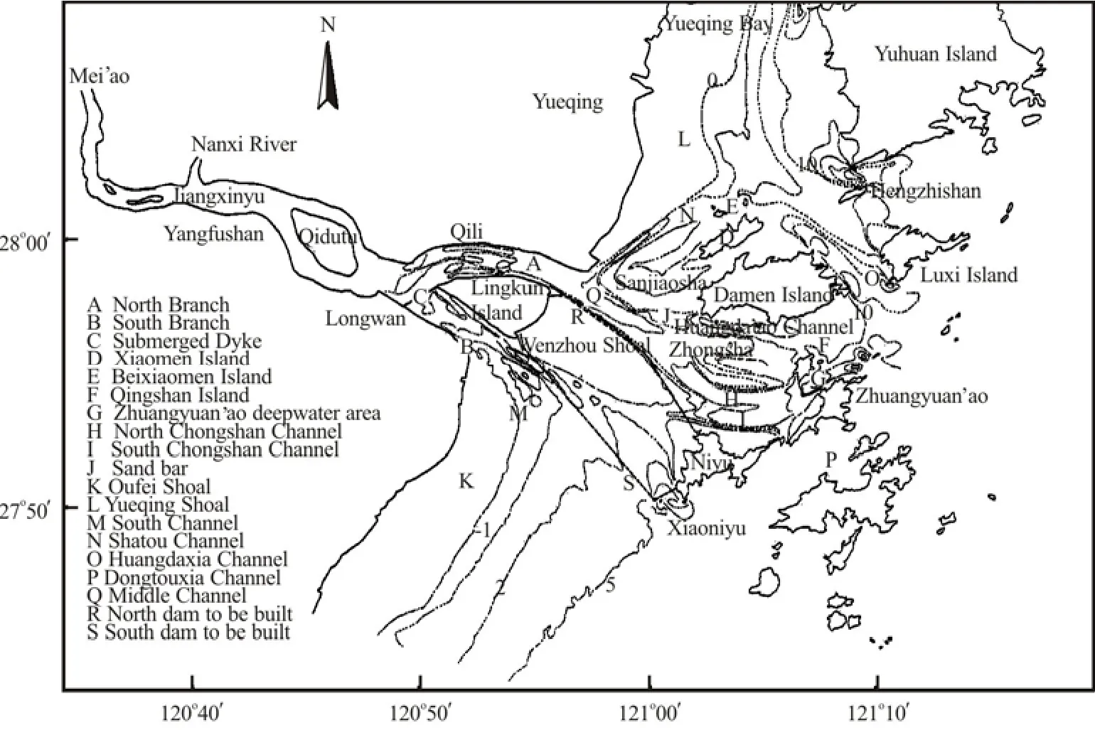
Fig.1 Sketch of the Oujiang Estuary
In this article, a reclamation scheme shown in Fig.1 is studied, which consists of north dam and south dam (dashed lines) connecting Lingkun Island and Niyu along the north side and south side of Wenzhou Shoal. The north dam goes along the 0 m isobath and is 14.5 km long, and the south dam goes from Lingkun Island to Xiaoniyu and from Xiaoniyu to Niyu, 16.5 km in length. Firstly, characteristics of hydrodynamics, sediment and evolution of Wenzhou Shoal are analyzed according to in-situ hydrological and topographic data. Secondly, a two-dimensional (2-D) tidal current and sediment mathematical model under the combined action of wave and current with irregular triangular grid is set up to carry out numerical simulations for the reclamation. The feasibility of the reclamation is demonstrated from the angle of its impacts on the surrounding hydrodynamic sediment.
There are a great variety of numerical methods on hydrodynamics and sediment movement in coastal and estuarine regions[1,2]. Numerical simulations of hydrodynamics and sediment movement are widely applied in studies of various coastal and estuarine problems[3-14]such as reclamations[9,10]. In coastal and estuarine waters, the main dynamical factors that influence the sediment movement are tidal currents and waves. “Wave lifting sediment and tidal current transporting it” is recognized as the sediment movement mechanism. At present, 2-D mathematical models of sediment movement which take into account the joint action of tidal current and wave are widely used[2]. In such mathematical models, the effect of “wave lifting sediment and tidal current transporting”, it is usually taken into account through wave radiation stress, bed resistance of wave and current and sediment carrying capacity by wave and current[2].
2. Hydrodynamic sediment characteristics of the Oujiang Estuary[15]
In the Oujiang Estuary, as a strong tidal estuary, tides can reach up to 78 km upstream from its mouth, with a river basin area of 1.8×10⁴km2. According to perennial observational data in the Oujiang River, the average yearly runoff is 470 m3/s, the yearly average total amount of fresh water discharge is 1.4805×10¹⁰m3, the measured maximum flood peak discharge at Weiren Station was 2.28×10⁴m3/s ( July 20,1952 ), and the minimum was 10.6 m3/s (October 20, 1967), the measured maximum runoff is 2000 times of the minimum. The Oujiang River lacks sediment, with yearly average suspended load concentration of 0.131kg/m3. The suspended load transport amount is only about 2.051×10⁶t a year, while the maximum yearly transport amount was 5.594×10⁶t (in 1975) and the minimum was 4.23×10⁵t (in 1979). If the bed load is considered and is estimated as 10% of the suspend load amount, the amount of the bed load transport is only about 2×10⁵t-5×10⁵t. On the basis of multi-year observations, the average water diversion ratios of the South Branch and the North Branch of the Oujiang River are 21% and 79% during flood, and 26% and 74% during ebb, respectively, the average sediment diversion ratios of the South Branch and the North Branch of the Oujiang River are 20% and 80% during flood, and 22% and 78% during ebb .
The Oujiang Estuary is dominated by semidiurnal tides with the average tidal range of over 4m and the maximum tidal range of over 7 m. Tidal currents in the Oujiang Estuary belong to shallow water semidiurnal tidal currents. Affected by topography, the tidal currents are basically to and fro currents from surface to bottom. The strongest tidal current is in the North Branch. The measured maximum surface flooding velocity is 1.94 m/s, and the measured maximum surface ebbing velocity is 2.68 m/s. The measured maximum bottom flooding velocity is 1.26 m/s, and the measured maximum bottom ebbing velocity is 2.14 m/s. The measured maximum vertically averaged flooding velocity ranges from 1.02 m/s to 1.59 m/s, the measured maximum vertically averaged ebbing velocity ranges from 1.01 m/s to 2.45 m/s. The measured mean vertically averaged flooding velocity ranges from 0.56 m/s to 0.97 m/s, and the measured mean vertically averaged ebbing velocity ranges from 0.65 m/s to 1.46 m/s.
The suspended load concentration is higher in the areas of Longwan, Qili, Huanghua, Sanjiaosha, the South Branch and South Channel. The maximum vertically averaged concentrations during flood tide and ebb tide measured in 1999 and 2002 were all over 1.0 kg/m3. The highest concentrations occur near Longwan and Qili. The average concentrations were up to 3.157 kg/m3at flood and 2.610 kg/m3at ebb in Longwan, and 1.816 kg/m3at flood and 2.711 kg/m3at ebb in Qili. The maximum concentrations were up to 7.351 kg/m3at flood and 5.976 kg/m3at ebb in Longwan, and 9.866 kg/m3at flood and 8.976 kg/m3at ebb in Qili. Near Xiaomen Island and in Yueqing Bay, the concentrations were the minimum, with the average sediment concentration during flood tide or ebb tide being below 0.3 kg/m3. The distribution law of suspended load concentration shows that it is higher near the river mouth and it diminishes outside the mouth.
According to analyses on samplings during hydrometric measurements in 1999, 2002 and 2005, the average median sized50of suspended load in the Oujiang Estuary is approximately in the range from 6×10⁻⁶m to 8×10⁻⁶m.
According to analyses on samplings of bed materials in 1999, 2002 and 2005, the median sized50of the bed load in the Oujiang Estuary is 6.9×10⁻⁶m -1.694×10⁻⁴m near Longwan, 3.2×10⁻⁶m - 2.398×10⁻⁴m in the North Branch, 6.9×10⁻⁶m - 1.694×10⁻⁴m in Middle Channel, 3.37×10⁻⁵m - 2.679×10⁻⁴m in the South Branch and from 5×10⁻⁶m to 9×10⁻⁶m outside the South Branch.
3. Evolution of Wenzhou Shoal
There are two groups of flooding current and ebbing current to the north and south of Wenzhou Shoal flowing into and out of the North Branch and the South Branch[6]. The Wenzhou Shoal is gradually submerged during flood and emerges gradually during ebb. During flood, part of flooding current from South Chongshan Channel goes across the lower part of Wenzhou Shoal, converges with flooding current from sea to the South Branch and goes along the south edge of the shoal. The tidal water in the middle part and the lower part of Wenzhou Shoal comes from the flooding current to the north of it (the tidal prism of Wenzhou Shoal is about 2×10⁸m3during the spring tide, with the south side and north side providing about 1×10⁸m3apiece). During ebb, the water on the Wenzhou Shoal falls into two parts to flow down the shoal, with one part flowing into South Chongshan Channel to the north of the shoal, and the other part into the ebbing current to the south of the shoal, in a proportion of about 2:8.
The axis of Wenzhou Shoal is basically in the main directions of flooding and ebbing currents to the north side and south side of the shoal. The Wenzhou Shoal stands in weak currents between two groups of flooding current and ebbing current to the north and south of Wenzhou Shoal flowing into and out of the North Branch and the South Branch[6], so the suspended loads carried by flooding and ebbing currents are apt to deposit on the shoal. A forest of islands outside the Oujiang Estuary can well keep the outer sea wave from entering, and the water in the shoal is relatively calm, so the deposited sediment on the shoal cannot easily be lifted by the wave except in rough climate conditions. Therefore, the geographical position and hydrodynamic conditions create a stable sedimentation environment.
The comparative analyses on bathymetric charts measured in 1958 through 1999 show that the 0 m isobath in the east side of the shoal was about 6 km away from Niyu in 1958, and only 1 km in 1986, moving down 5 km, with an average of 200 m a year. Over 28 years (from 1958 to 1986), the shoal was in average aggraded by 1.27 m, with the deposition rate of 0.045 m per year. The siltation thickness in the upper part, middle part and lower part was 1.4 m, 1.1m and 1.3 m, respectively, with the deposition rate of 0.05 m, 0.039 m and 0.046 m per year, respectively, showing little differences in siltation thickness and deposition rate in the three parts. In the next 13 years (from 1986 to 1999), the shoal was in average aggraded by 0.36 m, with the deposition rate of 0.028 m per year. The siltation thickness in the upper part, middle part and lower part was 0.5 m, 0.4 m and 0.2 m, respectively, with the deposition rate of 0.038 m, 0.031 m and 0.015 m per year, respectively. Compared with the first 28 years, the deposition rate in the upper and middle part did not change much, but it was decreased obviously in the lower part.
The above analyses show that: (1) the area between Lingkun Island and Niyu is not a tidal passage, (2) the Wenzhou Shoal was first universally aggraded and was stretched downstream(0 m isobath), then its middle and upper parts deposit and its lower part is in a blanceable state with slight siltation, and the shoal over 0 m isobath tends to be stable(Fig.2).
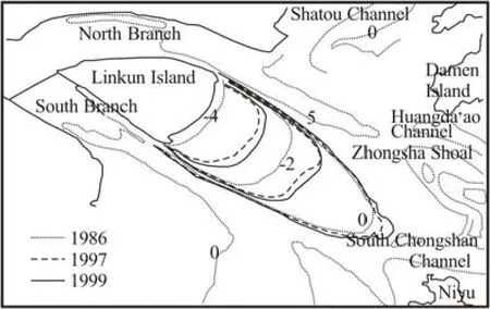
Fig.2 Evolution of Wenzhou Shoal
As Wenzhou Shoal remains stable, its middle and upper parts expand year after year, the reclamation of Wenzhou Shoal goes in harmony with its evolution trend, and can be seen as a help from human action in its expanding.
4. Numerical model
4.1Governing equations
4.1.1 Tidal current equations
In coastal and estuarine regions, because the horizontal scale is much larger than vertical scale, the three-dimensional tidal current problem can be approximately simplified to depth-integrated 2-D problem. In Cartesian coordinate system (x,y), the 2-D tidal current equations taking into account wave action are as follows:
Continuity equation
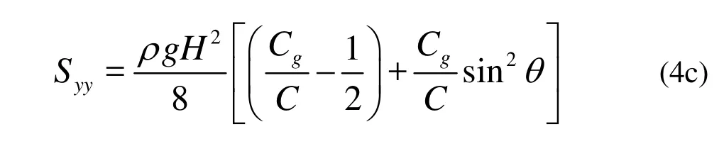
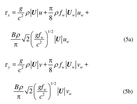
wherexandyare the coordinates in the Cartesian coordinate system, in whichxyplane coincides with still sea surface,uandvare the depth-averaged velocity components inxandydirections, respectively,gis the gravity acceleration,ρis the water density,NxandNyare the eddy viscosity coefficients of water inxandydirections, respectively,tis time,fis the Coriolis parameter,ζis the water surface displacement relative to thexyplane,his the still water depth,Sxx,Sxy,SyxandSyyare the four components of the radiation stress of the wave expressed as
If let H=0, that is, the wave action is not taken into account, the model is reduced to the tidal current model.
The open boundary conditions are
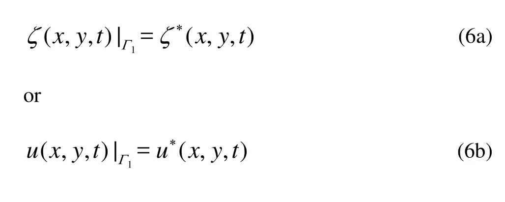
in which1Γ is the open boundary, subscript * expresses a given value(for example, the measured value).
The closed boundary conditions are
in which Γ2is the closed boundary, and n is the normal unit vector.
The initial conditions are:
where subscript 0 expresses a given value (for example, the measured value).
4.1.2 Suspended load equation
In Cartesian coordinate system (x, y), the depth-integrated non-equilibrium sediment transport equation is

in which S is the depth-averaged suspended sediment content,Dxand Dyare diffusion coefficients of the suspended sediment in x andy directions, respectively,α is the settlement rate of the suspended sediment, ω is the settling velocity of the suspended sediment, S*is the sediment-carrying capacity of the current and wave.
The open boundary conditions are:
Inflow:

The closed boundary conditions are:
whereΓ2is the closed boundary.
The initial conditions are:
4.1.3 Seabed deformation equations
The seabed deformation equations consist of the equation related with the suspended load and the equation related with the bed load, which are as follows:
(1) Seabed deformation equation related with the suspended load
in whichsηis the seabed erosion and deposition thickness caused by the suspended load,0γis the dry density of the suspended load.
(2) Seabed deformation equation related with the bed load
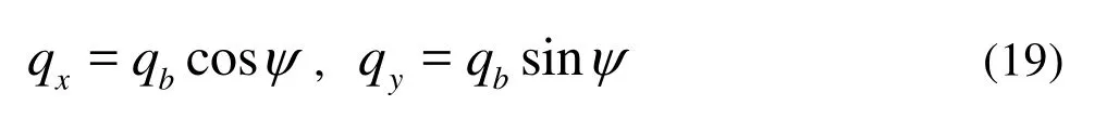
in whichηbis the seabed erosion and deposition thickness caused by the suspended load,γbis the dry density of the bed load,qxandqyare components ofqbinxandydirections, respectively, as the bed load transport in unit width and unit time, to be calculated by Dou formula, which takes the wave into account:
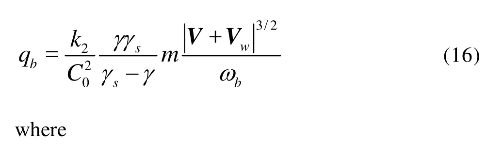
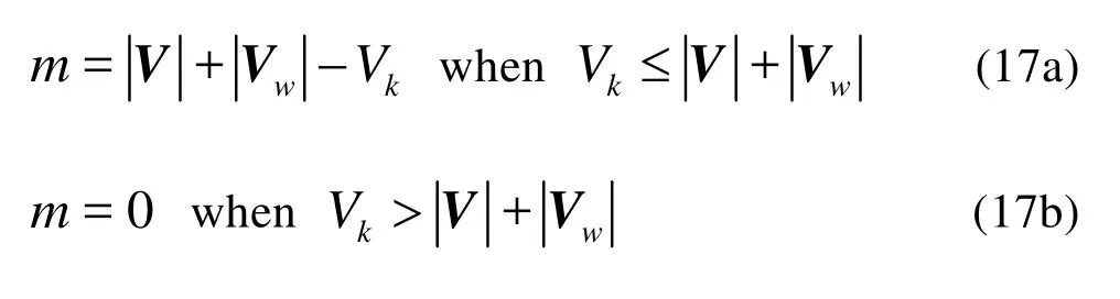
in whichVis the average water flow velocity vector,Vwis the average characteristic velocity vector of the wave,Vkis the critical incipient velocity of the bed load, which, due to Dou formula, is expressed as
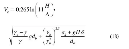
in whichγb∗is the stable dry density(γb
∗=γbfor a fine sediment),dbis the median size of the bed load,εkis the cohesive force parameter (εk=0.50cm3/s2m3,for the natural sand),δis the film water thickness parameter,δ=1.2×10⁻⁶cm, Δ is the seabed roughness height.
Suppose that the included angle betweenV+Vwandxaxis isψ, then
The total erosion and deposition thickness isηs+ηb.
4.2Numerical schemes
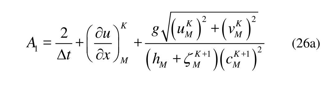
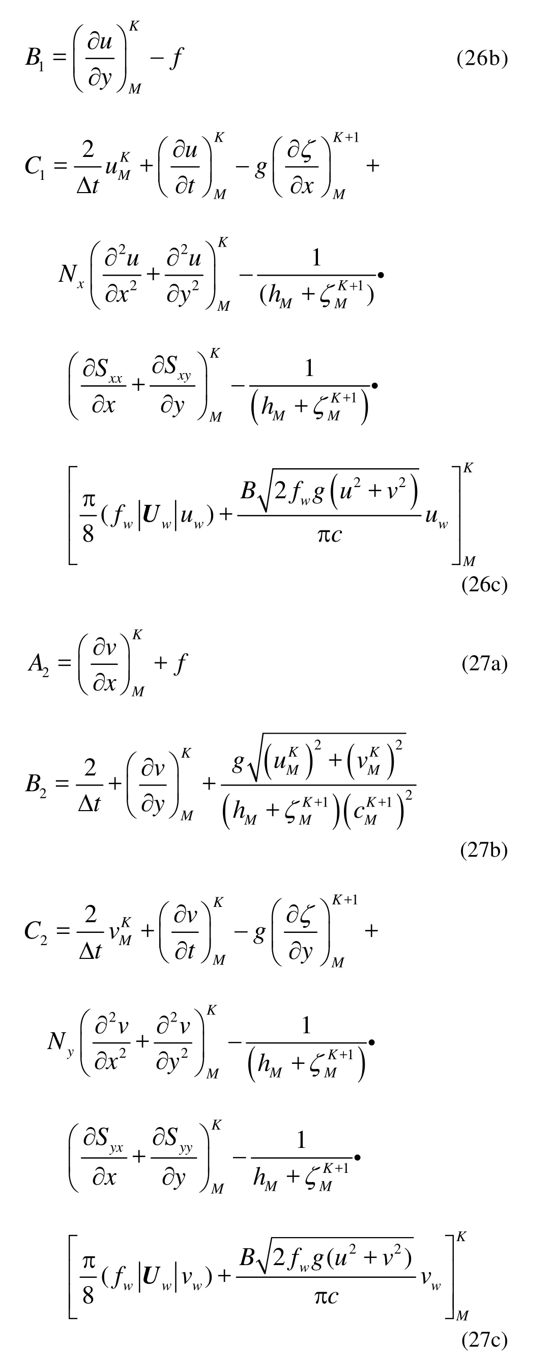
A second-order explicit finite difference numerical method with triangular grid is adopted for tidal current Eqs.(1)-(3), and the explicit finite difference numerical method is used for Eqs.(9), (14) and (15). The differential equations are as follows, respectively,
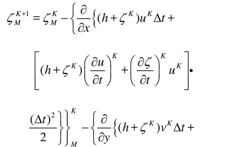
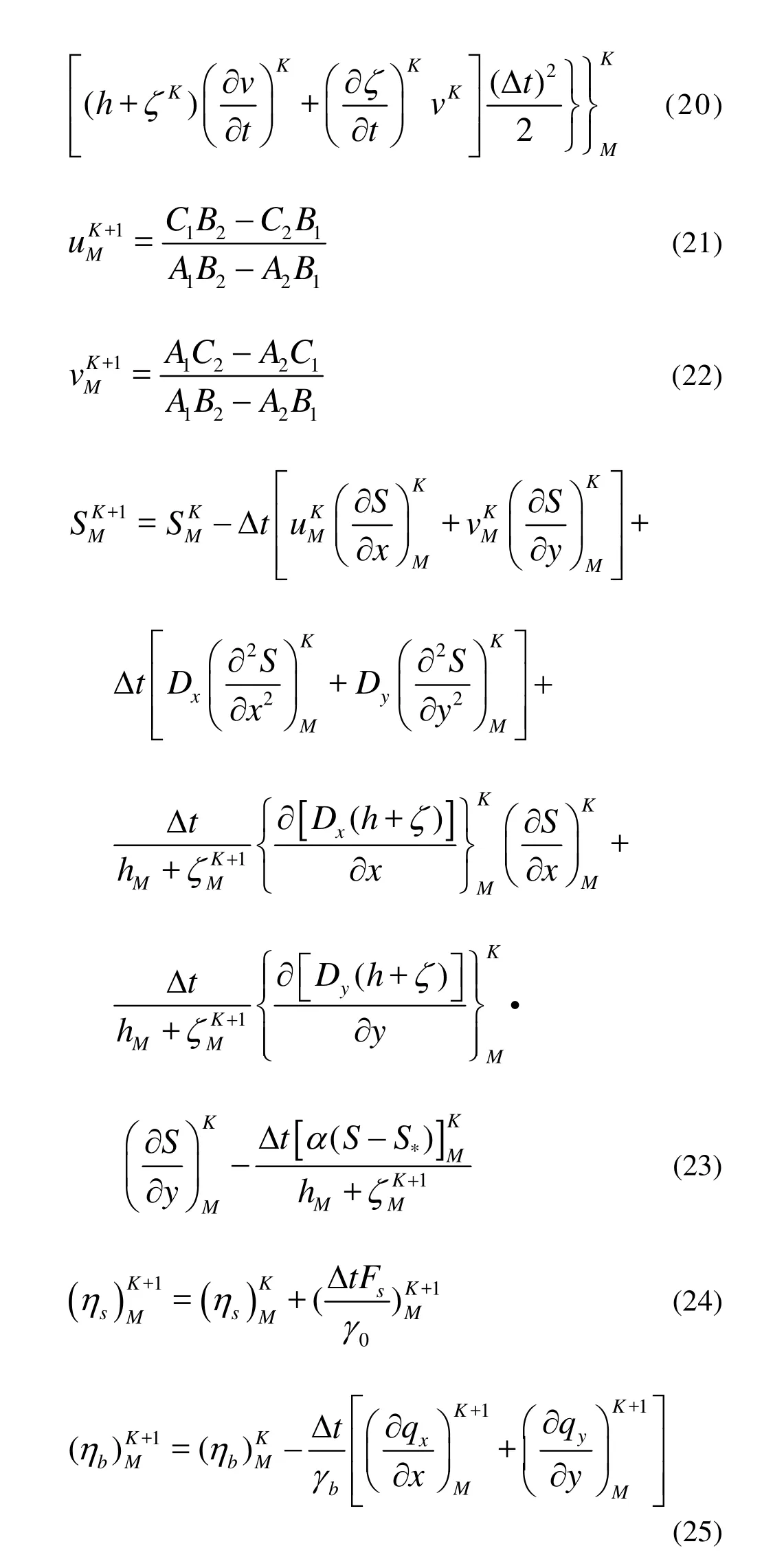
where M is the number of nodal points, K is the time step index, Δt is the time step of integration, expressions ofA1,B1, C1,A2, B2, C2are as follows:
The discretization scheme of spatial partial derivatives in Ref.[16] is adopted.
4.3Computation domain and grid division
The computation domain is shown in Fig.3. The west boundary reaches Mei’ao, and the east boundary reaches 121o20'E. The north boundary reaches the head of Yueqing Bay, and the south boundary reaches 27o44'N. It is about 72.2 km long in the east-west direction and about 71.5 km wide in the south-north direction. There are 43 islands included in the computation domain.
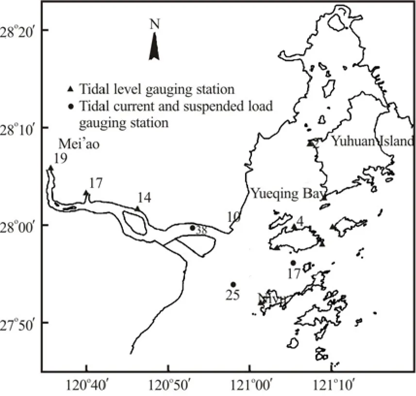
Fig.3 The computation domain
Irregular triangular grid is adopted to divide the computation domain (See Fig.4). There are 3.3606×10⁴triangular grid nodes and 6.4614×10⁴triangular elements in the domain. The spatial resolution ranges from 30 m to 800 m.
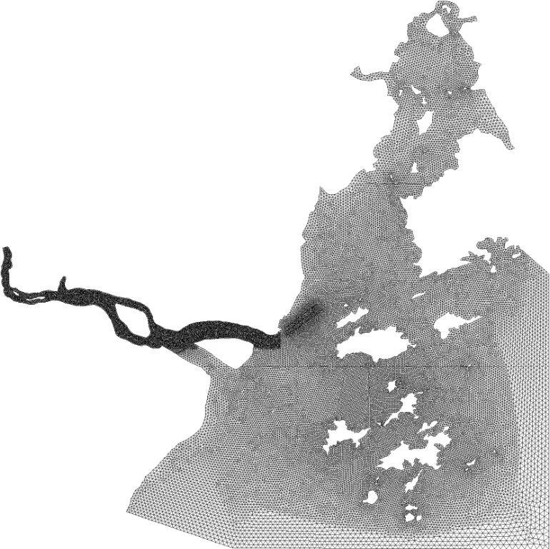
Fig.4 The grid
4.4Some important parameters
There are a few parameters in the mathematical model that must be determined reasonably before the model is used for simulations. The determination of the parameters will be proceeded as follows.
(1) Manning roughness coefficientn, which is taken as in the range of 0.010-0.025.
(2)Nx,Ny,Dx,Dy, which are taken as 10 m2/s according to Ref.[2] and the characteristics of the Oujiang Estuary.
(3)ω
Most coasts and estuaries in China are of silt sandy coast, and the particle size of suspended sediment is fine with a little variation. The sediment settles and is transported in a form of flocculated mass under the action of saltine water. Tests show that the size of the flocculated equivalent particle is about in the range of 1.5×10⁻⁵m - 3×10⁻⁵m, and the corresponding settling velocity is in the range of 1×10⁻⁴m/s-6×10-4m/s. In this study,ωtakes the value of 4×10⁻⁴m/s.
(4) Sediment-carrying capacityS*
Sediment-carrying capacity is a very important parameter in the suspended load simulation. According to the analysis of the field data, the following expression is obtained
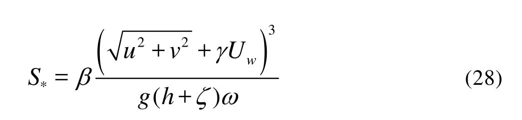
whereβis the settling probability, and in this study,β=0.08755,γis an empirical coefficient determined by the field data, andγ=0.4 is adopted in this sea area[15].
(5)γ0
Dry density of the suspended loadγ0can be determined by the formula
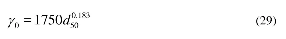
whered50is the median size of the suspended load, and in this study,d50=0.008mm, soγ0≈723kg/m3.
(6)Wave characteristics
Wave characteristicsH,θ,Cg,Care determined by the wave model[17].
4.5Verification of the model
There are three synchronous hydrometric surveysconducted in the Oujiang Estuary. The first (spring tide) was conducted from October 10 to 12, 1999, the second (moderate tide)from October 12 to 13,1999, and the third(neap tide) from October 14 to 15,1999. There are 16 tidal level observation stations in each survey. And there are 15, 19, 18 stations (see Fig.3) in the first, second and third survey, respectively, where the current velocity, the current direction and the suspended load content are measured. For comparison, three tidal simulations were conducted for the same periods as the above surveys. The simulated results are in good agreement with the observed data in both magnitude and phase. The verification of the tidal level and the tidal current can be found in Ref.[6]. Figure 5 shows time series comparisons of the model results with measured data for the suspended load concentration.
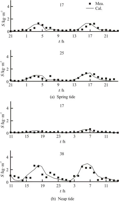
Fig.5 Comparisons of suspended load concentration time series
Bathymetric charts measured in October 1997 and October 1999 are used for verification of the seabed deformation. The calculated and measured results are shown in Fig.6. It can be seen from Fig.6 that calculated results agree well with the measured one.
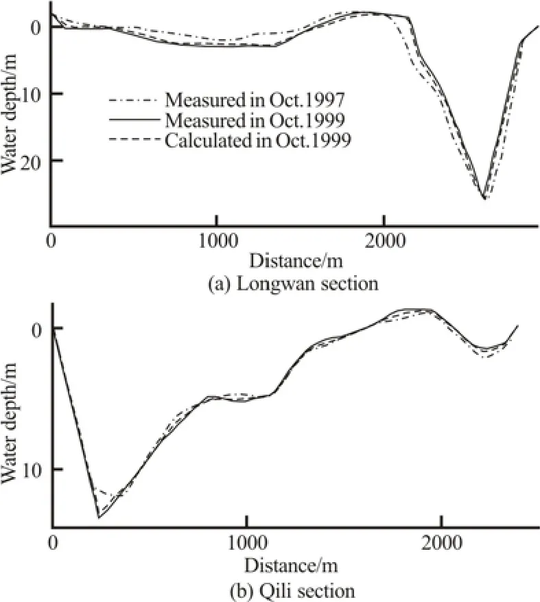
Fig.6 Verification of seabed erosion and deposition
5. Impacts of reclamation on surroundinghydrodynamic sediment environment
5.1Effect on tidal current
It can be seen from Figs.7 through 10 that the reclamation does not significantly change the computed flood and ebb current fields in the river including upstream of Longwan, the North Branch, waterways and channels outside the North Branch, the South Branch except near the south dam and north dam of the reclamation.
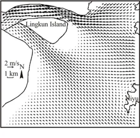
Fig.7 Flood current vectors before reclamation
The changes of the maximum flooding and ebbing velocity and the average flooding and ebbing velocity during spring tide in some major areas before and after the reclamation are listed in Table 1. It can be seen from Table 1 that there are significant changesof the tidal current velocities only in South Chongshan Channel and South Channel. As the reclamation blocks off the water passing through South Chongshan Channel to Wenzhou Shoal, so the current velocities in South Chongshan Channel decreases. The south dam plays the role of guiding and regulating the current to increase the velocity in the South Channel.
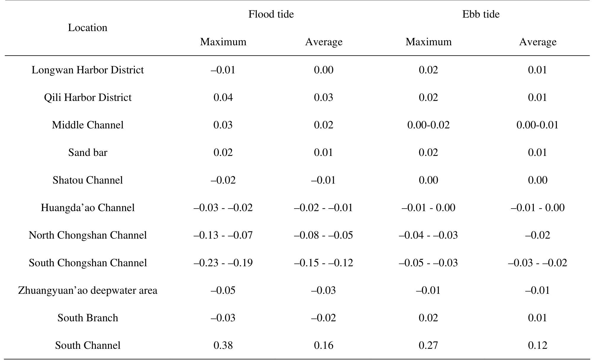
Table 1 Changes of flood and ebb velocity during a spring tide cycle (m/s)
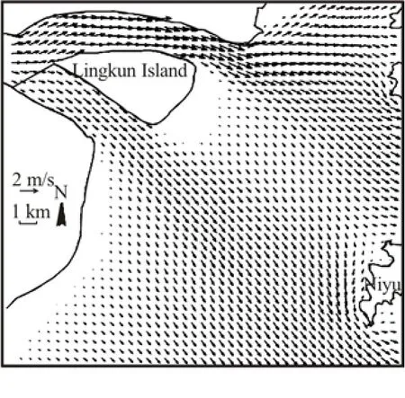
Fig.8 Ebb current vectors before reclamation
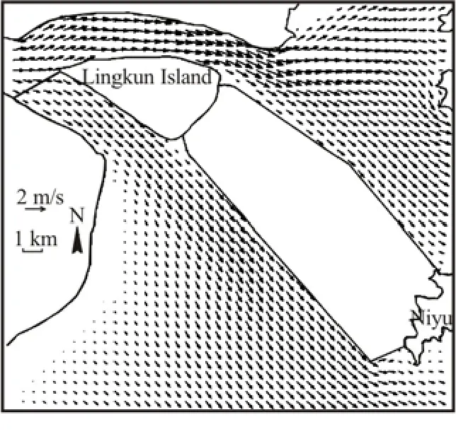
Fig.9 Flood current vectors after reclamation
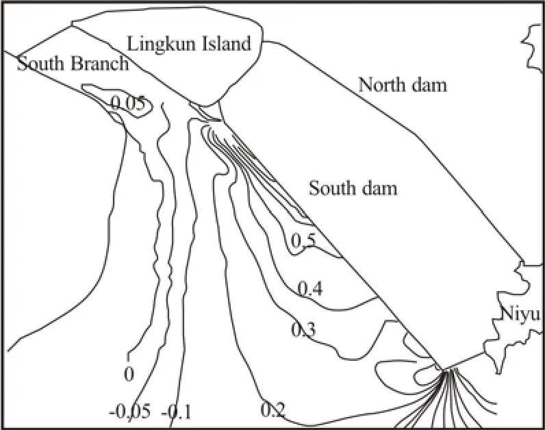
Fig.10 Ebb current vectors after reclamation
5.2Effect on water diversion ratio of the South Branch and the North Branch
After the reclamation, the tidal volume through the South Branch is decreased by 0.71% during the flood tide and increased by 1.81% during the ebb tide, and that through the North Branch is increased by1.4% during the flood tide and increased by 0.6% during the ebb tide. The changes of the tidal water throughput through the South Branch and the North Branch are less than 1.81%, within the range of computation error. Therefore, the reclamation has little effect on the water diversion ratio of the South Branch and the North Branch.
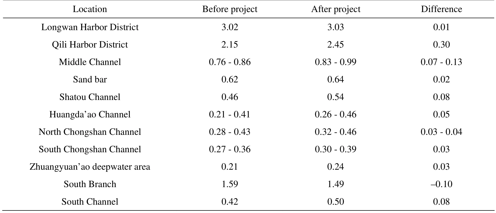
Table 2 Changes of mean suspended load concentration during a spring tide cycle (kg/m3)
5.3Effect on suspended load concentration
Table 2 shows a comparison of the average suspended load concentration during spring tide in some major areas before and after the reclamation. It can be seen from Table 2 that the suspended load concentration is not significantly affected by the reclamation.

Table 3 Prediction of erosion and deposition at different places (m)
5.4Effect on seabed erosion and deposition
The computation results of the seabed erosion and deposition in some major areas after the reclamation are listed in Table 3. It can be seen that the erosion and deposition thicknesses in Longwan Harbor District, Qili Harbor District and channels outside the North Branch caused by the reclamation are very small and are all within the range of allowable errors in the water-depth measurement.
As the flooding and ebbing current velocities near South Channel all increase after the reclamation, the seabed near South Channel scours. The maximum scouring occurs close to the root of the south dam of the depth of 1.5 m. The farther away from the dam, the smaller the scouring. There is little erosion and deposition in the South Branch (Fig.11). The erosion and deposition outside South Channel is not serious and is acceptable.
5.5Effect on resources of harbors and navigational
channels
It can be seen from the above Tables 1 through 3 that the reclamation has little impacts on hydrodynamic sediment conditions of Longwan Harbor District, Qili Harbor District, Middle Channel, Huangda’ao Channel, sand bar, Zhuangyuan’ao deepwater area. Before and after the reclamation, the current velocity in Longwan Harbor District basically see no significant changes, while the current velocity increases appreciably in Qili Harbor District, all in a slightly scouring state with the scouring thicknesses of 0.008 m - 0.017 m. The current velocity increases appreciably in Middle Channel and sand bar, all in a slightly scouring state too with the scouring thicknesses of 0.004 m -0.015 m. The current velocity decreases appreciably in Huangda’ao Channel, in a slightly deposition state, with the deposition thicknesses of 0.022 m - 0.025 m. The floodingcurrent velocity decreases by less than 0.05 m/s and the ebbing current velocity decreases by less than 0.01 m/s in Zhuangyuan’ao deep water area in spring tide, with the deposition thickness of 0.051 m. Therefore, the reclamation has little impacts on resources of harbors and navigational channels.
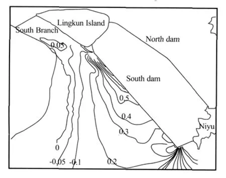
Fig.11 Distribution of erosion and deposition outside South Branch
In addition,as far as the North Branch and outside channels are concerned, the reclamation can prevent the wave propagating into the navigation channels in the directions of ESE, SE, SSE and S, therefore, the sediment on the Wenzhou Shoal will not be lifted by waves and transported by the tidal current to navigation channels, which is beneficial to the maintenance and stability of the present navigational channels and can improve the navigation conditions from the North Branch to Huangda’ao Channel.
5.6Effect on flood discharge and drainage of the Oujiang River
The tidal model was used to simulate the conditions of the runoff of a-hundred-year return period in the upstream of Oujiang River and spring tide outside its estuary coincide. The simulation results show that before and after the reclamation, the high tide levels and the low tide levels along the river upstream Longwan basically see no significant changes, and that the high and low tide levels along the river from Longwan to the mouth are driven up by only 0.01 m - 0.04 m. Therefore, the flood discharge and drainage of the Oujiang River will not be affected by the reclamation.
Summing up the above results, the reclamation between Lingkun Island and Niyu has little effect on the surrounding hydrodynamic sediment environment. Firstly, it has little or no negative impacts on the flood discharge and drainage of the Oujiang River, the water diversion ratio of the South Branch and the North Branch, and the resources of harbors and navigational channels, secondly, the erosion and deposition outside the South Branch are not serious and are in an acceptable level, thirdly, the reclamation can block off waves in the directions of ESE, SE, SSE and S from propagating to the navigation channels, and the sediment on the Wenzhou Shoal will not be lifted by waves and transported by the tidal current to the navigation channels, which is beneficial to the maintenance and stability of the present navigational channels and can improve the navigation conditions from the North Branch to Huangda’ao Channel. Therefore, the reclamation is feasible.
6. Socio-economic impacts of the reclamation
The construction of the north dam for the reclamation began in April 2003 and was completed in April 2006. In April 2007, a post evaluation was carried out by Ocean University of China. The results show that the above predicted results agree well with thein-situdata. The reclamation has the following socio-economic impacts:
(1) The reclamation will create a land of 88 km2to be exploited . The reclaimed land is worth up to RMB 1.69×10¹⁰.
(2) As the reclamation area links the mainland and islands, previously separated by the sea, the development space of Wenzhou city is extended 60 km to the east, the area of Wenzhou city is increased by 200 km2and is doubled.
(3) As the reclamation makes true the name of Wenzhou Peninsula, the territory of Wenzhou city is changed. It is indicated that Wenzhou will enter “East China Sea Age” from “Oujiang River Age”.
(4) The exploitation of tour and fishery resources of Dongtou Island will be promoted. After the reclamation, it is estimated, there will be 6×10⁴tourists per year to Dongtou Island for sightseeing. With the completion of “Nation Sea Park” in Dongtou Island, the number will increase by 10% at least, with an appreciable income from tourism.
(5) Zhuangyuan’ao deepwater harbor district of Wenzhou Port can be built.
Zhuangyuan’ao deepwater harbor district of Wenzhou Port lies inside the arc-shaped bay on the northwest coast of Zhuangyuan’ao. It is a good deepwater harbor facing the East China Sea in the east, joining Niyu in the southwest, bordering on Dongtou Island in the south, 1.5 km away from Qingshan Island in the north. This harbor has over 10 km long usable coastline, only 30 km away from the international navigation channel. The natural water depth is 15 m in the entrance navigation channel and over 15 m in the harbor basin. The harbor can have a throughput capacity of over 4×10⁷t including 5×10⁶TEUs. Large ships of 1.5×10⁵t can navigate or berth all day long, while those of over 2×10⁵t may alsoenter with tide. Now, Wenzhou Port has become one of the 19 hub ports in China.
(6) The indirect and potential socio-economic benefits will be huge and can not be estimated exactly.
7. Concluding remarks
Taking the reclamation between Lingkun Island and Niyu in the Oujiang Estuary as an example, based on an analysis of the natural sediment and hydrodynamic conditions and the seabed evolution, a numerical model of tidal current, sediment movement and seabed deformation under the combined action of tidal current and wave is developed and applied in the feasibility study of reclamation between two islands in a complex estuary from the angle of the effects on surrounding hydrodynamic sediment environments. The following conclusions are reached.
(1) The area between Lingkun Island and Niyu is a weak current area during both flood tide and ebb tide, and is not a tidal passage. It is in a deposition environment. The Wenzhou Shoal between the two islands is a well developed shoal and remains stable as a whole with its middle and upper parts emerging during low tides, which have been aggraded gradually. The Wenzhou shoal is suitable to be reclaimed.
(2)The reclamation between Lingkun Island and Niyu has little effect on the surrounding hydrodynamic sediment environment, with little or no negative impacts on the flood discharge and drainage of the Oujiang River, on water diversion ratio of the South Branch and the North Branch and on resources of harbors and navigational channels. Therefore, the reclamation is feasible.
(3) As the reclamation can block off waves in the directions of ESE, SE,SSE and S from propagating to the waters outside the North Branch, and hence the sediment on the Wenzhou Shoal will not be lifted by waves and transported by tidal current to the Middle Channel and Huangda’ao Channel, so it is beneficial for the maintenance and stability of the present navigational channels and can improve the navigation conditions from the North Branch to Huangda’ao Channel.
(4) The reclamation has huge socio-economic favorable impacts.
[1] LI Meng-guo, CAO Zu-de. A review on tidal current numerical modeling in coastal and estuarine waters[J].Acta Oceanologica Sinica, 1999, 21(1): 111-125(in Chinese).
[2] LI Meng-guo. A review on mathematical models of sediment in coastal and estuarine waters[J].The Ocean Engineering, 2006, 24(1): 139-154(in Chinese).
[3] KUANG Cui-ping. A numerical model for flow-salt-sediment movement in tidal estuaries[J].Journal of Hydrodynamics,Ser. B,1996, 8(3): 1-7.
[4] CHAO Xiaobo, SHANKAR N. J. and CHEONG H. F. A three-dimensional multi-level turbulence model for tidal motion[J].Ocean Engineering,1999, 26(11): 1023-1038.
[5] DRAGO M., IOVENITTI L.σ-coordinates hydrodynamic numerical model for coastal and ocean three-dimensional circulation[J].Ocean Engineering,2000, 27: 1065-1085.
[6] LI Meng-guo, WANG Zheng-lin. Tidal flow numerical simulation of the Oujiang Estuary[J].Journal of Yangtze River Scientific Research Institute,2002,19(2): 19-22(in Chinese).
[7] ZHANG Xin-fen, JIANG Xing-ke and XU Feng-jun. The application of 2D current-sediment model in the study on choosing course in Tonggu channel of Shenzhen port[J].Journal of Hydrodynamics, Ser. A,2004, 19(Suppl.): 877-883(in Chinese).
[8] LONG Jiang, LI Shi-yu. Finite element method combining the 1-D and 2-D hydrodynamic modeling of the Pearl River outlets[J].Journal of Hydrodynamics, Ser. A,2007, 22(4): 512-519(in Chinese).
[9] LU Yong-jun, ZUO Li-qin and JI Rong-yao et al.Effect of development of Caofeidian Harbor Area in Bohai Bay on hydrodynamic sediment environment[J].China Ocean Engineering,2008, 22(1): 97-112.
[10] LU Hai-yan, PAN Cun-hong and LU Xiang-xing et al. Numerical simulations of the third Haining reclamation project effect on the tidal bore in the Qiantang River[J].Chinese Journal of Hydrodynamics,2008, 23(5): 484-491(in Chinese).
[11] LI Meng-guo, HAN Xi-jun and YANG Shu-sen et al. Study on tidal current and sediment problems of deepwater channel project of Nansha Harbor Disrict of Guangzhou Port[J].Chinese Journal of Hydrodynamics,2008, 23(3): 321-330(in Chinese).
[12] JIANG Heng-zhi, SHEN Yong-ming and WANG Shou-dong. Numerical simulation study on threedimensional tidal flow and salinity in the Oujiang Estuary[J].Chinese Journal of Hydrodynamics,2009, 24(1): 63-70(in Chinese).
[13] PAN Cun-hong, LU Hai-yan and YU Pu-bing. Numerical simulation of sediment transport in discontinuous shallow water flows with triangle grids[J].Chinese Journal of Hydrodynamics,2009, 24(6): 778-785(in Chinese).
[14] JIANG Heng-zhi, SHEN Yong-ming. Numerical study on salinity stratification in the Oujiang Estuary[J].Journal of Hydrodynamics,2009, 21(6): 835-842.
[15] ZHENG Jing-yun, LI Meng-guo and MAI Miao et al. Hydrographic and sediment analyses of the Oujiang Estuary[J].Journal of Waterway and Harbor,2008, 29(1): 1-7(in Chinese).
[16] LI Meng-guo. Application of triangular mesh in mathematical models of hydrodynamic and hydroenvironment field[J].Hydro-Science and Engineering,2001, (3): 59-64(in Chinese).
[17] LI Meng-guo, LIU Bai-qiao. Numerical study on the wave field in Oujiang Estuary[J].Journal of Waterway and Harbor,2001, 22(1): 1-8(in Chinese).
September 25, 2009, Revised February 20, 2010)
* Project supported by the Natural Science Foundation of Tianjin (Grant No. 08JCZDZT00200).
Biography:LI Meng-guo (1964-),Male, Ph. D., Professor
2010,22(3):338-350
10.1016/S1001-6058(09)60063-9

- 水动力学研究与进展 B辑的其它文章
- BROADBAND ROTOR NOISE PREDICTION BASED ON A NEW FREQUENCY-DOMAIN FOUMULATION*
- A SIMPLIFIED NUMERICAL MODEL OF 3-D GROUNDWATER AND SOLUTE TRANSPORT AT LARGE SCALE AREA*
- IMPROVED DEM-CFD MODEL AND VALIDATION: A CONICAL-BASE SPOUTED BED SIMULATION STUDY*
- FLOWS THROUGH ENERGY DISSIPATERS WITH SUDDEN REDUCTION AND SUDDEN ENLARGEMENT FORMS*
- NUMERICAL SIMULATIONS OF WAVE-INDUCED SHIP MOTIONS IN TIME DOMAIN BY A RANKINE PANEL METHOD*
- SENSITIVITY STUDY OF THE EFFECTS OF WAVE-INDUCED VERTICAL MIXING ON VERTICAL EXCHANGE PROCESSES*