
Development of an adaptive Kalman filter-based storm tide forecasting model*
2016-12-26 06:51MOK莫启明LAI黎宇轩HOI许嘉贤
水动力学研究与进展 B辑 2016年6期
K. M. MOK (莫启明), U. H. LAI (黎宇轩), K. I. HOI (许嘉贤)
Department of Civil and Environmental Engineering, University of Macau, Macau SAR, China,
E-mail: kmmok@umac.mo
Development of an adaptive Kalman filter-based storm tide forecasting model*
K. M. MOK (莫启明), U. H. LAI (黎宇轩), K. I. HOI (许嘉贤)
Department of Civil and Environmental Engineering, University of Macau, Macau SAR, China,
E-mail: kmmok@umac.mo
Extreme storm tide usually causes flooding of low-lying land in a coastal city. Hence, developing an efficient and accurate forecasting model for issuing a timely warning is important. In this study, an adaptive Kalman filter-based storm tide forecasting model was proposed and applied to the inner Harbor of Macau. The model is a dynamic linear regression model with the harmonic tidal prediction, wind speed, wind direction and atmospheric pressure as its input parameters. With persistence forecast of weather assumed during the prediction period, the model was tested with 40 cases of storm tide induced by tropical cyclones in Macau between 2005 and 2012. Success was found for forecasts with lead times up to 3 hours. The proposed adaptive model is considered a practical tool for storm tide forecast in small coastal cities.
adaptive model, flooding, Kalman filter, Macau, storm tide
Introduction
Storm surge is a phenomenon of abrupt rise in local sea level due to the presence of a tropical cyclone, which causes persistent strong onshore wind pushing the water body towards inland as well as the sucking effect due to decreased atmospheric pressure. These surges combined with the astronomical tide form the storm tide. Since storm tide could cause severe flooding in the low-lying regions of a coastal city, developing a model that could forecast accurately its temporal variation is important for releasing a timely flood warning. For example in Macau, a small Special Administrative Region (SAR) of only 30.4 km2in the southern coast of China, the low-lying area in its inner harbor has been suffering from flooding due to storm tide. Because of this, the Chief Executive Officer of the Macau SAR government in April of 2009 signed an administration order that stipulates the issue of a storm tide warning by the Meteorological and Geophysical Bureau (SMG) when the sea level is expected to exceed street level of the inner harbor. With a tide gauge already installed at the location, astatistical forecasting model is suitable for Macau. In fact, statistical models are commonly used for forecasting storm tide of a small urban area due to its lesser data (usually sea level and meteorological measurements) and computational demand. Many empirical storm surge prediction models in previous studies were developed based on Artificial Neural Network (ANN)[1,2], and Support Vector Regression (SVR)[3]. However, those models are non-adaptive and retraining is necessary when new data are available. To overcome this shortcoming, an adaptive storm tide forecasting model that could adjust its model coefficients automatically is proposed by using Kalman filtering in this study. The methodology is tested with 40 cases of storm tide induced by tropical cyclones in Macau.
1. Methodology
Based on a simulation study on the storm tide in Macau[4], the following empirical model with timevarying coefficients is proposed for predicting the storm tideat the kthh.
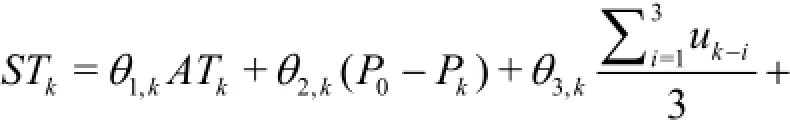
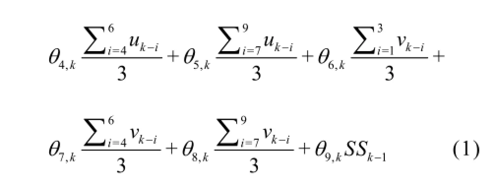
where (ATk)is the astronomical tide prediction at the kthh by a harmonic model with 7 tidal constituentsandThe difference between the standard atmospheric pressure (P0) and the local atmospheric pressure at the kthhaffects the amount of sea-level rise due to decreased atmospheric pressure. The north-south component (uk-i)and the east-west component (vk-i)of the wind acceleration account for the influence of wind setup at the(k -i)thh, and they are calculated as:
where (wk-i)and (φk-i)represent the wind speed and direction at the(k -i )thh, respectively. Finally,SSk-1represents the predicted storm surge level (STk-1-ATk-1)at the (k -1)thh. Note that when Eq.(1) is used to predict storm tide of multiple hours ahead, it requires the input of unknown meteorological information in the future. For this, a persistent meteorological condition is assumed. For example, when the storm tide levels of 9 hours aheadare predicted at the kthh, the unknown hourly wind speed, direction, and the atmospheric pressures fromh are assumed to have the same values as those measured at the kthh. It is believed that this persistence forecast assumption for weather is acceptable for a lead time of no more than 10 h. The adaptiveness of the model is realized by updating the time varying model coefficients (θ1,k,…,θ9,k)with the Kalman filter[5,6]whenever new measurements of the sea level are available.
For implementation, Eq.(1) is expressed in the form of a generalized dynamic linear model

where STkdenotes the predicted storm tide of theh,is a row vector containing the input functions used in Eq.(1)
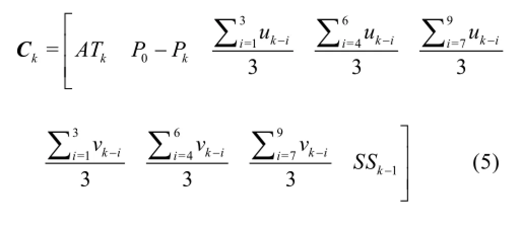
and θkis the state vector which contains the unknown model coefficients of thekthh

Each model coefficient of the kthh is assumed to differ slightly from its value of the previous hour by
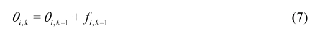
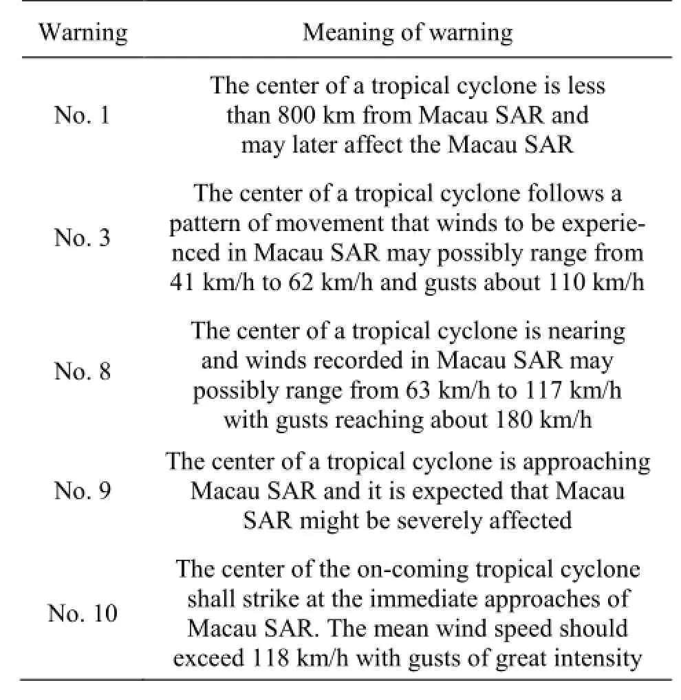
Table 1 Tropical cyclone warning system in Macau
The difference fi,k-1is assumed to follow a normal distribution with zero mean and a standard deviation σi. Note that there is no subscriptkin the standard deviation, meaning that it is independent of time. Then, Eq.(7) can be written in the following vector form


Table 2 Root mean squared errors of the predictions with lead times of 1 h, 3 h, 6 h and 9 h
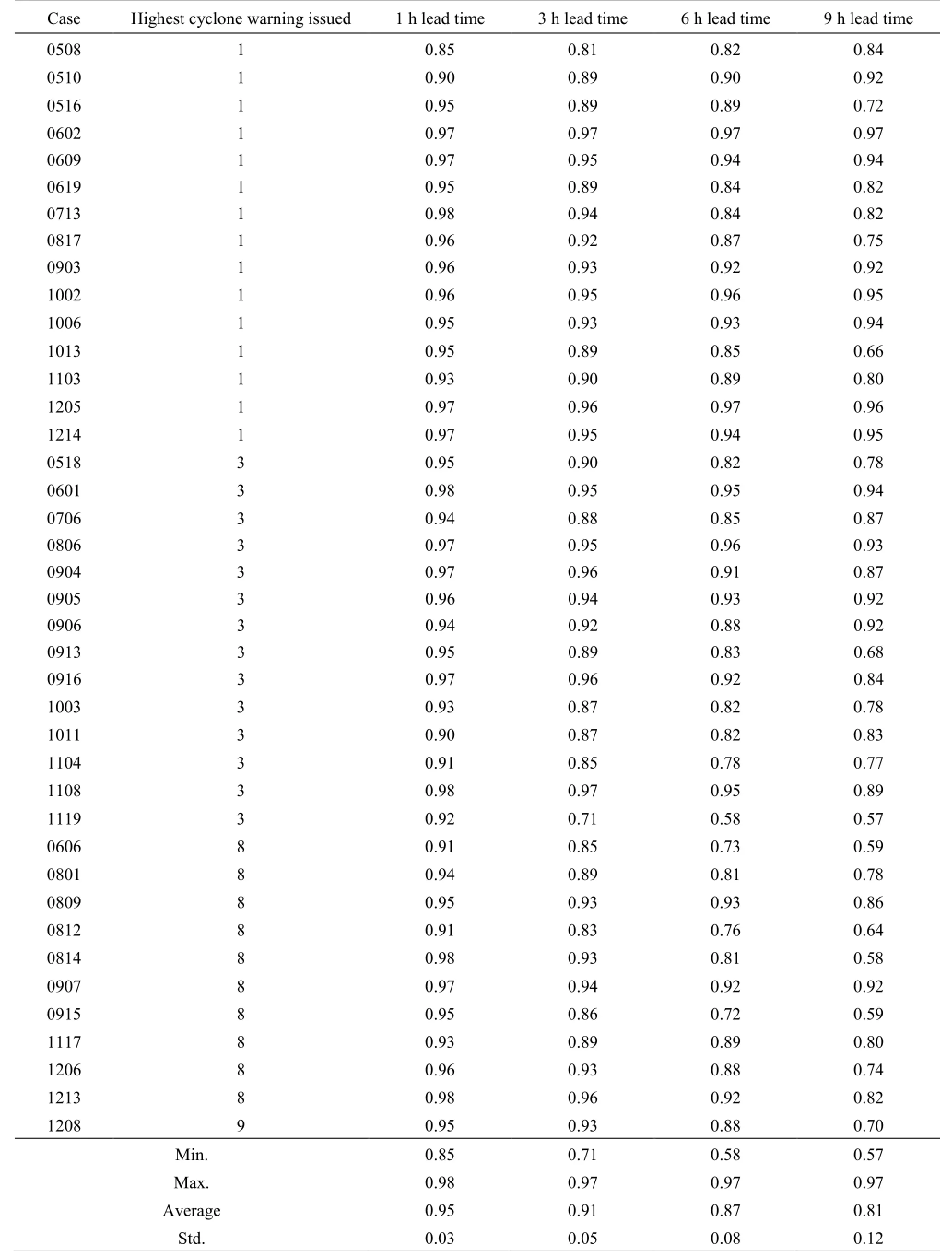
Table 3 Coefficients of determination of the predictions with lead times of 1 h, 3 h, 6 h and 9 h
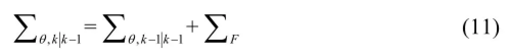
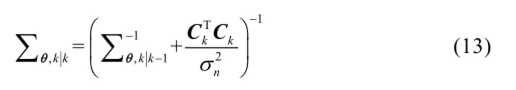
where Fk-1follows a Gaussian i.i.d. vector process with zero mean and covariance matrixdiag. To update the model coefficients of theh, the measured sea levelat the kthh is required, and it relates to the parameter vectorθkthrough the following equation


During the filtering step, the measurement of the kthh is available. Then, the model coefficients are updated by maximizing the posterior probability density function

2. Results and discussion
The proposed model is applied to forecast 40 cases of storm tide recorded in the Macau inner harbour caused by approaching tropical cyclones during 2005 to 2012. The warning of a threat by an approaching tropical cyclone is officially issued in Macau by the SMG. Table 1 shows their five-level warning system. The proposed model starts to predict the sea level when a warning No. 1 is issued. It stops when all warnings are cancelled. The atmospheric pressure and the wind velocity data used were obtained from a weather station installed at the SMG headquarter.
Overall performances of the model for predicting the hourly sea levels with lead times of 1 h, 3 h, 6 h and 9 h are evaluated against measurements. Results of root-mean-squared-error (RMSE) and coefficient of determination (R2)for the 40 studied cases are shown in Table 2 and Table 3, respectively. The 40 cases listed in the tables are grouped together based on the highest tropical cyclone warning issued in each case. In general, the model performs the best for predictions of 1 h lead time with the smallest average RMSE (0.12 m) and the largest averageR2(0.95). Accuracy of the model decreases as the forecast lead time increases. For the predictions with a lead time of 3 h, the average RMSE and the average R2are 1.3 times and 96% of those with a 1 h lead time, respectively. When the forecast lead time increases to 6 h and 9 h, the average RMSE increases to 1.7 and 2.0 times of that with a 1 h lead time. The correspondingR2decreases to 87% and 85% of that with a 1 h lead time. Note that even the accuracy of the model prediction decreases, the average values ofRMSE=0.16 m and R2=0.91for the 3 h ahead prediction are still considered good. For a small coastal city like Macau, warnings with a lead time of 3 h may be sufficient.
Temporal variations of the sea level predicted by the model for the cases with the highest storm tide level among each group shown in Tables 2 and 3 are examined with measurements. Figure 1 shows the tidal level forecasted and measured for Case 0609 (BOPHA), which had the highest storm-tide level for the cyclone warning No. 1 group. The model could predict the tidal variation including the peak value and its corresponding arrival time well even with a lead time of 9 h.
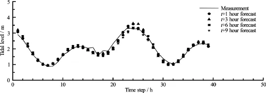
Fig.1 Comparison of the storm tide predictions with measurements for Case 0609 (BOPHA)
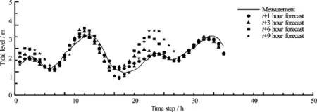
Fig.2 Comparison of the storm tide predictions with measurements for Case 1119 (NALAGE)
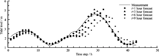
Fig.3 Comparison of the storm tide predictions with measurements for Case 0814 (HAGUPIT)
Figure 2 shows the temporal variations of the tidal level forecasted and measured for Case 1119 (NALAGE), which had the highest storm-tide level for the cyclone warning No. 3 group. The model in this case could predict the tidal variation well with a lead time of up to 3 h. The model predictions deviate much from the measurements near the third local maximum (between 26 h and 32 h) when the forecast lead time increases to 6 h and 9 h. This is caused most likely by drastic changes of the wind parameters that were assumed constant in that prediction period. However, the actual peak that occurred at around 15 h was still captured quite well by all forecasts of different lead times.
Figure 3 shows the temporal variations of the tidal level forecasted and measured for Case 0814 (HAGUPIT), which had the highest storm-tide level for the cyclone warning No. 8 group as well as the highest storm-tide level among the 40 studied cases. For predictions with a lead time of 1 h, the model can capture the flood and ebb of the storm tide well. The tidal peak was slightly overestimated by 2%, and its arrival time was predicted 1 h early. Meanwhile, forecasts with a lead time of 3 h can still capture the tidal variation well with the peak being overestimated by 10%, and its arrival time also being forecasted 1 h early. As the forecast lead time becomes longer to 6 h and 9 h, the predicted tidal levels show a 2 h to 3 h lag time while keeping the peak value relatively close to the observations.
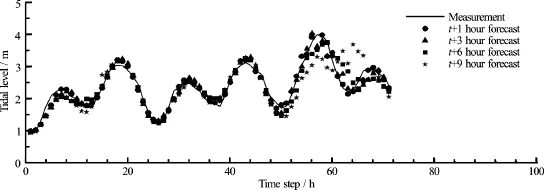
Fig.4 Comparison of the storm tide predictions with measurements for Case 1208 (VICENTE)
Table 4 Performance of the peak tidal level during 2005 to 2012
Figure 4 shows the temporal variations of the tidal level forecasted and measured for Case 1208 (VICENTE), which had the highest and only cyclone warning No. 9 issued among the 40 studied cases. Similar to the Case 0814 (HAGUPIT) discussed earlier, predictions with lead times up to 3 h can capture the storm tide well. The tidal peak and its arrival time were predicted within 1% and one hour, respectively. However, as the forecast lead time becomes longer, the predicted sea level suffers again from the phase lag problem by up to 7 h.
As storm tide could cause flooding of the lowlying area, two parameters are of great importance for a warning issuing operation. They are the maximum or peak level of the storm tide and its arrival time. Two indexes are used to evaluate the performance of the forecasting model. They relative error of the forecasted storm-tide peak level,∆Hp, and the error of its arrival time,ETp. The relative error ∆Hpis written as
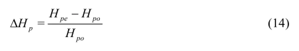
where Hpeand Hpodenote the peak level of the forecasted and observed storm tide, respectively. A∆Hpof zero indicates that the model predicts perfectly the peak level. The error of forecasted peak-arrival timeETpis

where Tpeand Tpoare the arrival time of the forecasted and observed peaks, respectively. Since the overall performance of the forecasting model with lead times up to 3 h is very satisfactory, evaluation of the model performance on predicting the tidal peak level and its arrival time focuses on forecasts with lead times up to 3 h. Table 4 summarizes results of the 40 studied cases in groups of the highest cyclone warning issued in each case. In general, the model tends to over-predict the peak level. Forecasts with a lead time of 1 h show that the model can predict values of the tidal peak level within 9% of the measurements with their corresponding arrival time predicted within 2 h of the observed value. As for the forecasts with a lead time of 3 h, the model can predict values of the tidal peak level within 18% of the measurements with their corresponding arrival time predicted within 3 h of the observed value.
3. Conclusions
An adaptive Kalman filter-based storm tide forecasting model was developed and applied to the inner Habour of Macau for verification in this study. The model was tested with 40 cases of storm tide induced by tropical cyclones with success. Forecasts with leadtimes up to 3 h have their average RMSE less than 0.16 m, average R2greater than 0.90, peak level value and its arrival time within 18% and 3 h of the measurements, respectively. Meanwhile when the forecast lead time became longer to 6 h and 9 h, the accuracy of the model decreased by 100% on average. This could be due to the persistence forecast assumption made for weather during the prediction. Therefore, the present model is practical for a small city like Macau when flood warning announcement with a lead time of 3 h is sufficient. However, if accurate forecasts of longer lead time are desired, improvement of the model performance could be achieved by providing future meteorological parameters needed for the model input through, for example the Weather Research and Forecasting (WRF) model. Further studies are recommended.
Acknowledgements
This work was supported by the Research Committee (Grant No. MYRG2014-00038-FST) of the University of Macau and the Science and Technology Development Fund (Grant No. 079/2013/A3) of the Macau SAR Government. The Marine and Water Bureau, and the Meteorological and Geophysical Bureau of Macau SAR are thanked for supplying the tide gauge data and meteorological data.
[1] Lee T. L. Neural network prediction of a storm surge [J]. Ocean Engineering, 2006, 33(3-4): 483-494.
[2] Tseng C. M., Jan C. D., Wang J. S. et al. Application of artificial neural networks in typhoon surge forecasting [J]. Ocean Engineering, 2007, 34(11-12): 1757-1768.
[3] Rajasekaran S., Gayathri S. and Lee T. L. Support vector regression methodology for storm surge predictions [J]. Ocean Engineering, 2008, 35(16): 1578-1587.
[4] Lai U. H., Hoi K. I., Mok K. M. Development of an adaptive empirical model for storm tide simulation [J]. Coastal Engineering Proceedings, 2014, 1(34): doi: 10.9753/icce.v34.management.3.
[5] Choi I. C., Mok K. M., Tam S. C. Solving harmonic sealevel model with Kalman filter: A Macau case study [C]. Carbonate Beaches 2000. Virginia, USA, 2002, 38-52.
[6] Yuen K. V. Bayesian methods for structural dynamics and civil engineering [M]. New York, USA: John Wiley and Sons, 2010, 68-98.
(Received June 25, 2016, Revised October 31, 2016)
* Biography:K. M. MOK, Male, Ph. D., Professor

- 水动力学研究与进展 B辑的其它文章
- Energy saving by using asymmetric aftbodies for merchant ships-design methodology, numerical simulation and validation*
- Development of Cartesian grid method for simulation of violent ship-wave interactions*
- Numerical study on the effects of progressive gravity waves on turbulence*
- Experimental tomographic methods for analysing flow dynamics of gas-oilwater flows in horizontal pipeline*
- Coupling of the flow field and the purification efficiency in root system region of ecological floating bed under different hydrodynamic conditions*
- Modelling hydrodynamic processes in tidal stream energy extraction*