“遥感数字图像处理”教学改革初探*
2013-04-29 01:53:37陈锋锐,乔家君,闫卫阳,张喜旺,杨玲
计算机时代
2013年6期
陈锋锐,乔家君,闫卫阳,张喜旺,杨玲
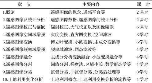
摘 要: 遥感数字图像处理是地理信息系统专业的核心课程,针对遥感数字图像处理的自身特点和目前该课程的教学现状,从优化教学内容、完善教学手段、激发学生兴趣、注重实验教学、提高学生动手能力等方面对该课程的教学进行了一系列改革。教学结果表明,这些措施可以有效促进学生的学习兴趣,并加深他们对知识的理解。
关键词: 教学改革; 遥感数字图像处理; 遥感; 地理信息系统
中图分类号:TN911.72 文献标志码:A 文章编号:1006-8228(2013)06-67-02
Preliminary discussion on teaching reform of remote sensing digital image processing
Chen Fengrui, Qiao Jiajun, Yan Weiyang, Zhang Xiwang, Yang Ling
(College of Environment and Planning, Henan University, Kaifeng, Henan 475004, China)
Abstract: Remote sensing digital image processing is one of the core courses of geographic information system specialty. Considering its characteristics and teaching status, a series of reform measures are presented in order to promote the students' interest in learning and deepen their understanding of knowledge. The measures are optimizing teaching contents, improving teaching method, stimulating study interest, and enhancing experimental teaching.
Key words: teaching reform; remote sensing digital image processing; remote sensing; geographic information system
0 引言
随着遥感技术的快速发展,海量的遥感图像被获得,这些影像在社会生产和生活中发挥了越来越重要的作用。遥感图像已广泛应用于农业、林业、地质、海洋、气象、水文、军事、环保等领域,它不仅为这些行业提供基础数据;同时,伴随着电子地图、导航定位的出现和广泛使用,遥感图像已经成为人们生活的一部分,不断改变着人类对世界的认知。1997年教育部对我国高等教育专业目录进行修订,对部分专业进行压缩,但在地理学下却新增了地理信息系统本科专业,授予理学和工学学位。目前国内已有140多所高校开设了地理信息系统专业,遥感数字图像处理是该专业的核心课程。因此,探讨该门课程的教学内容、教学手段和方法,对提高遥感数字图像的处理水平有非常重要的意义。
遥感数字图像处理作为地理信息系统专业的核心课程,在学生的知识构建中起着重要的作用[1]。……
登录APP查看全文
猜你喜欢
内蒙古教育(2021年20期)2021-03-08 01:09:14
甘肃教育(2020年14期)2020-09-11 07:57:50
计算机教育(2020年5期)2020-07-24 08:53:38
家庭影院技术(2019年11期)2019-12-09 09:14:30
作文世界(小学版)(2018年4期)2018-10-16 17:13:34
东方教育(2017年19期)2017-12-05 15:14:48
唐山文学(2016年2期)2017-01-15 14:03:59
快乐作文·低年级(2016年12期)2017-01-03 20:52:44
快乐作文·低年级(2016年6期)2016-06-24 18:58:40
体育师友(2013年6期)2013-03-11 18:52:18