
Comprehensive Grain Potential Regionalization Study Based on the Farm land Grading Results
2014-04-11 01:00LinaGUOYunaJIAXiaokeGUAN
Asian Agricultural Research 2014年1期
Lina GUO,Yuna JIA,Xiaoke GUAN
1.College of Mining Engineering,Hebei United University,Tangshan 063009,China;2.College of Resources and Environment,China Agricultural University,Beijing 100193,China
Farmland is the most basic means of labor for agricultural production,and plays an irreplaceable role in ensuring the human existence,and especially the regional food security.For China,affected by natural conditions,the regional distribution of farmland is unbalanced,with large differences;at same time,due to more people and less land,the population pressure on land will persist;with the industrialization and urbanization,the farmland scarcity will become more prominent[1],and regional food security issues will also attract more attention.Therefore,only by clearly knowing the amount,quality and spatial distribution of farmland can we achieve scientific management of farmland,and effectively use and protect increasingly scarce farmland resources;only by fully understanding the production capacity of farmland and its potential distribution pattern can we grasp the potential and direction of farmland consolidation and utilization,fully tap the food production potential of farmland,and improve regional food production and supply capacity.
Currently,the farmland grading carried out by the land resources departments is mainly based on the principles for formation of productivity of farmland[2].In accordance with the natural and economic attributes of farmland,it is to carry out quantitative assessment of farmland quality[3],and grade the farmland.The research results basically realize the scientific quantification of quality and spatial distribution of farmland.At present,the farmland grading results have been determined in the basic farmland[4-5].There has been some progress in the application and research of cultivated land requisition-compensation balance[6-8],farmland production capacity checking[9-12]and the land consolidation[13-16].These studies are the important practice of scientific management of farmland.
However,from the studies based on grading results,we can find that the researches of grading results on grain potential pattern of farmland are rarely reported.Although some scholars have checked the grain production capacity of farmland at different levels and its spatial distribution based on grading results,the main focus of the study is to use the grading results to estimate the grain production capacity that can be supplied by the farmland.Even if the grain potential areas are divided according to the productivity checking results,the regionalization is relatively general,and the advantage of regions with different potential has not been pointed out.The researches of grading results on land consolidation are mostly concentrated in consolidation and planning,evaluation after consolidation,and checking of farmland consolidation potential,but there are few researches on the consolidation direction based on different potential areas.
Based on this,we use various in dices based on farmland grading results(light and temperature/climate potential index,natural index and utilization index),combined with the area of regional farmland,check the advantage index of comprehensive grain potential of farmland,thus dividing the comprehensive grain potential regions of farmland,to help understand and master different grain potential areas of farmland,as well as the future direction of potential mining in regions with different advantages.Meanwhile,this result can serve as the guidance for the regionalization of farmland productivity checking,and can test the reasonableness of productivity checking results.
The comprehensive grain potential of farmland defined in this article is affected by the farmland area and the comprehensive grain potential of farmland per unit area;the comprehensive grain potential of farmland per unit area is a composite index combining the natural potential and utilization potential of per unit area of farmland,which only represents the level of grain potential of farmland per unit area,having no yield significance.The natural potential of per unit area of natural potential in this article is signified by the difference between the light and temperature potential index of per unit area of farmland and natural quality index of farmland;the per unit area of utilization potential of farmland is signified by the weighted average of difference between natural quality index of per unit area of farmland and the utilization index.
1 Materials and methods
1.1 Overview of the study areaWith a latitude ranging from 38°34′to40°15′N,and longitude ranging from 116°43′to118°04′E,Tianjin is a metropolis in northern China and one of the five national central cities of the People's Republic of China(PRC).It is governed as one of the four direct-controlled municipalities of the PRC,and is thus under direct administration of the central government.Tianjin borders Hebei Province and Beijing Municipality,bounded to the east by the Bohai Gulf portion of the Yellow Sea.Part of the Bohai Economic Rim,it is the largest coastal city in northern China.Tianjin is a dual-core city,with its main urban area(including the old city)located along the Hai River,which connects to the Yellow and Yangtze Rivers via the Grand Canal;and Binhai,a New Area urban core located east of the old city,on the coast of Bohai Sea.The municipality is generally flat,and swampy near the coast,but hilly in the far north,where the Yan Mountains intrude into northern Tianjin.The highest point in the municipality is Jiuding Peak in Jixian on the northern border with Hebei,at an altitude of 1078.5 m(3538 ft).Tianjin features a four season,monsoon-influenced climate,typical of East Asia,with cold,windy,very dry winters reflecting the influence of the vast Siberian anticyclone,and hot,humid summers,due to the monsoon.The changes in the climatic conditions within the city are not obvious.The city has jurisdiction over 12 districts and counties.According to 2007 statistics,the city's total land area was1191700 hectares,and there was480000 hectares of farmland involved in the grading,accounting for 40.28%of the total city's land area.According to the grading results of farmland,the city's total farmland is divided into nine natural grades(large area of II,III,VIand VII)and nine utilization grades(large area of III,IV,VI and VII).The farmland with higher grades is mainly the irrigable land and paddy field that have good irrigation conditions.
1.2 Data sourcesIn this paper,the basic data are from farmland grading results in Tianjin,with grading unit as the basic data unit.We choose light and temperature potential index,natural quality grade index,utilization coefficient and utilization grade index as the primary analysis data;the data of farmland area comes from the classification data of land use status in 2007 provided by Tianjin Municipal Bureau of Land Resources and Housing Administration.
Using the factor method,the farmland grading in Tianjin is carried out based on determining the standard arable land system(identifying the farmland with irrigation conditions as winter wheat-summer corn two crops a year,the dry land without irrigation conditions as spring corn one crop a year)and winter wheat as a reference crop(0.806 of corn production ratio).The calculation of the relevant data in this article is also based on these two premises.
1.3 Research ideas and methods
1.3.1Basic ideas.In this paper,with the farmland grading unit as the basic calculation unit,according to the light and temperature potential index of designated crops and the standard farming system determined by grading,we firstly calculate the comprehensive light and temperature potential index of per unit area of farmland Ai(Ai=,and assume it as the food production level index when the farmland is not restricted by any soil conditions.
Then we calculate the difference between the comprehensive light and temperature potential index of per unit area of farmland Aiand the natural quality grade index per unit area(signified by R in the calculation).The natural quality grade index is the food production level index assuming farmland is not affected by socioeconomic factors under the current quality conditions,so R can be regarded as the natural potential index of per unit area of farmland,that is,by transforming the current natural limitations on farmland,the production level index can be improved.
Similarly,we calculate the difference between the natural quality grade index and utilization grade index(signified by Y in the calculation),and view it as the food production level index that can be improved by perfecting the socio-economic conditions and the management level of farmland.
Once again,using the area-weighted method,we aggregate the natural potential index of farmland and utilization potential index into the district and county scale,to calculate the natural potential index of per unit area of farmland in various districts and counties(signified by Ra)and the utilization potential index(signified by Ya).
Finally,with the districts and counties as the summary unit,the comprehensive potential(advantage)regions are classified.
1.3.2Research methods.
(i)Aggregated comparative advantage index.Studies of comparative advantage can be traced to Ricardo's theory of comparative advantage,believing that any country or region has its own relatively favorable production conditions,and can carry out the specialized and large-scale production of certain goods[17-18].Based on this study,the comparative advantage of comprehensive grain potential of farmland can be regarded as the fundamental basis for regional agricultural production layout,consolidation and potential tapping of farmland.In this article,we use the widely applied aggregated comparative advantage index at home[18-20]to measure the comparative advantage index of comprehensive grain potential of farmland in the districts and counties.The aggregated comparative advantage index consists of two parts,scale advantage index and efficiency advantage index.They are calculated in the article as follows:

(a)SAI(Scale Advantage Index).where SAIisignifies the scale advantage index of farmland in county or district i;Sgiand Sgqsignify the farmland area of county or district i and the whole municipality,respectively;Stiand Stqsignify the land area of county or district i and the whole municipality.
If SAIi>1,it indicates that compared with the city level,the farmland in district i has scale advantage;if SAIi<1,it indicates that the farmland scale in district i is ata disadvantage.The smaller the value of SAIi,the more obvious the scale disadvantage.
(b)EAI(Efficiency Advantage Index).It is calculated as follows:
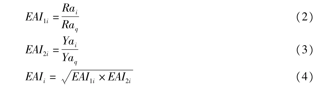
where EAIiis the comprehensive grain potential advantage index per unit area of farmland in district i;EAI1iand EAI2iare the natural potential advantage index and utilization potential advantage index of grain production per unit area of farmland in district i,respectively;Raiand Yaiare the average natural potential index and average utilization potential index per unit area of farmland in district i,respectively;Raq and Yaq are the average natural potential index and average utilization potential index per unit area of farmland in the whole city,respectively.
If EAIi>1,it indicates that the grain potential in district i has efficiency advantages,namely the grain potential advantages per unit area of farmland;if EAIi<1,it indicates that the grain potential is at a disadvantage,and if EAIiis smaller,the the rewill be less grain potential advantages per unit area of farmland.

where AAI is comprehensive grain potential advantage index of farmland;the meaning of SAIiand EAIiis the same as above.
(ii)Hierarchical clustering.Based on the calculation results of formula(5)(Table 1),we use SPSS statistical analysis software to carry out hierarchical clustering regionalization of 12 districts and counties in Tianjin City.
2 Results and analysis
2.1 Comparative advantage analysis of comprehensive grain potential of farm land in the districts and countiesFrom Table 1,we can find that among the 12 districts and counties of Tianjin City,Ninghe,Baodi,Jinghai,Beichen,Jixian and Wuqing have comparative advantage in the comprehensive grain potential of farmland(AAI>1),and Wuqing and Jinghaihave relatively obvious advantages;Xiqing,Dagang,Hangu,Tanggu,Dongli and Jinnan have comparative disadvantage in the comprehensive grain potential of farmland(AAI<1),and Tanggu and Hangu have relatively obvious disadvantages.
Through the further analysis of the component in dices of AAI,it can be found that the grain production of farmland has scale advantage area(SAIi>1),and the distribution of disadvantage area(SAIi<1)is basically consistent with the comprehensive grain potential advantage and disadvantage areas,indicating that the scale index of farmland has a strong positive effecton the comprehensive advantage index.
The districts and counties with EAI1>1 include Dagang,Tanggu,Hangu,Dongli,Jinnan,Ninghe and Jinghai,and EAI1of Tanggu is the biggest.The natural potential has advantages,indicating that there are more limiting factors in the natural conditions of farmland for the grain production in these districts and counties than in other districts and counties(Tanggu with the most limiting factors in the natural conditions of farmland),the natural quality conditions of farmland is poor,and in the future,we can overcome these natural limitations to mine the natural production potential of farmland;for the districts and counties with EAI1<1,the natural quality conditions of farmland are better,and the natural quality conditions of farmland are the best in Xiqing with the smallest EAI1.
The districts and counties with EAI2>1 include Xiqing,Dagang,Hangu,Dongli,Beichen,Jixian and Wuqing,and Xiqing and Beichen have the obvious advantages in the utilization potential.The utilization potential has advantages,indicating that the current farmland use in these districts and counties is not sufficient.
The reasons are as follows:(i)One the one hand,the socioeconomic situation of districts and counties is not good,and inadequate investment in food production causes insufficient use of farmland(such as Jixian and Wuqing,two agricultural counties);(ii)On the other hand,due to the high economic level in the districts and counties,affected by the opportunity costs,farmers' inadequate input to grain production causes insufficient use of farmland(such as Xiqing and Beichen,two suburban counties).
Therefore,in the future,we can mobilize the enthusiasm of farmers in developed regions for growing grain,and improve the agricultural production conditions in the underdeveloped regions,to tap the potential of farmland use.For the districts and counties with EAI2<1,EAI2does not have significant disadvantage values,indicating that the current overall level of utilization of farmland in Tianjin City is not high.

Table 1 The comparative advantage of comprehensive grain potential of farm land in the districts and counties of Tianjin
2.2 Regionalization of comprehensive grain potential of farm landAccording to the above calculation results,using SPSS16.0 for hierarchical clustering,we finally regionalized all the 12 counties into 4 regions based on the actual situation:I High potential-regions easy to be mined in the short term,II High potential-regions that can be mined in the long term,III Low potential-regions easy to be mined in the short term,IV Low potential-regions difficult to be mined in the long term(Fig.1).

Fig.1 Regionalization of comprehensive grain potential of farmland in Tianjin
Region I includes Beichen,Ninghe,Wuqing and Jixian.SAI,EAI,and AAI in these regions are all greater than 1,EAI1is less than 1,and EAI2is greater than 1,indicating that there is a lot of farmland in these regions,the natural quality of farmland is high with few restrictive factors,but the current level of utilization of farmland is low.
In the case of given natural conditions,the level of utilization of farmland is constrained by regional production conditions,such as capital,technology and labor;in fact,the level of regional-economic development can be used as the indicator reflecting the level of utilization of regional farmland[2].The level of regional economic development can be often influenced and regulated by the market,and the means of market regulation are relatively flexible,so the potential-mining can be achieved in the foreseeable future,and it is relatively easy.These regions are finally defined as I High potential-regions easy to be mined in the short term.
Region II includes Baodi and Jinghai.SAI,and AAI of the two regions are both greater than 1,while EAI is less than 1,EAI1is greater than 1 and EAI2is less than 1,indicating that there is a large area of farmland,and the farmland is fully utilized,but the natural quality is poor,and there are many soil constraints.
It will take time to improve the farmland quality by transforming the soil constraints,to achieve results,and the potential mining is more difficult compared with Class I,so these regions are defined as II High potential-regions that can be mined in the long term.
Region III includes Dongli,Jinnan and Xiqing.In these three regions,SAI and AAI are both less than 1,and EAI is slightly larger than 1.The advantages of EAI1and EAI2are not prominent,indicating that the amount of farmland,natural quality and the level of utilization are common in these regions.
The three regions are suburban areas of Tianjin,where the farmland is facing great occupation pressure,so these regions are defined as low potential regions.However,due to the better economic level of suburban districts and counties,the current situation of insufficient utilization of farmland can be improved by using the economic incentives to stimulate farmers to enhance food production inputs,so these regions are also the regions with potential easy to tap.
Region IV includes Hangu,Tanggu and Dagang.In the three regions,SAIand AAI both have obvious disadvantages,while EAI has obvious advantages,and the advantages of EAI1and EAI2are both prominent.This shows that there is a small area of farmland in these regions,and the farmland quality is poor with low utilization level.
Due to small farmland area,the integrated potential advantages will be smaller.From the natural conditions influencing the quality of farmland,the three regions are mainly located in coastal saline areas,and the quality of farmland is at a low level in the city.Despite the high level of economic development in these regions,less farmland and poor quality have made the agriculture(particularly farming)no longer have obvious advantages,so there regions are classified in IV Low potential-regions difficult to be mined in the long term.
3 Conclusions and discussions
3.1 Conclusions(i)The farmland scale advantage index has a strong positive effect on the comprehensive grain potential advantage index of farmland.Maintaining and increasing a certain area of farmland is the basis for ensuring the regional comprehensive grain production capacity of farmland.It is necessary to establish the farmland protection zones in the agricultural districts and counties with both scale advantage and comprehensive production potential advantage,which will help to stabilize the regional grain production.(ii)Based on the grading results of farmland,the natural quality grade of farmland is low in the districts and counties with natural potential advantage,that is,there are many natural constraints on farmland.There is a need to invest more engineering and technical measures in mining the natural potential of farmland.To fundamentally transform and overcome the constraint son farmland,it will take a long time,so the natural potential can be classified as long-term potential.(iii)The utilization potential advantage regions are mainly located in two types of districts and counties:one is the district or county where the low socio-economic level and insufficient grain production input lead to the insufficient utilization of farmland(such as Jixian,Wuqing,the two agricultural counties);the other is the district or county where the economic level is high,and affected by opportunity costs,farmers' insufficient input to grain production causes the insufficient utilization of farmland(such as Xiqing,Beichen,the suburban counties).Therefore,in the future,we can tap the potential of farmland use by mobilizing the enthusiasm of farmers for growing grain and improving the agricultural production conditions in the underdeveloped regions.
3.2 Discussions(i)The farmland grading chooses the index indicating the level of productivity as the quantitative basis.The index does not have a production sense,but it can indicate the level of production of farmland to a considerable extent,so in the case of unknown grade of farmland from which grain can obtain productivity,it is entirely possible to choose the difference between in dices as an indication of level of grain potential of farmland,and this difference index indicates the most original potential direction of farmland and the potential level.(ii)For the farmland consolidation and potential mining,there is a need to consider the size of farmland and per unit area of potential,to improve the overall efficiency of farmland consolidation,and put the limited investment in the areas with the most obvious out put benefit.The scale advantage has a positive effect on the comprehensive grain potential advantage of farmland,so it is believed that the protection and consolidation work of farmland should lay great emphasis on the regions with scale advantage,to improve the overall efficiency of protection and consolidation of farmland.Under normal circumstances,the use of the potential mining can draw on the market regulation,and natural potential mining requires more technology and capital inputs,so it is believed that the consolidation and potential tapping project of farmland in the short term can be put in the regions with scale advantage and utilization potential;the consolidation and potential tapping project of farmland in the long term can be put in the regions with scale advantage and natural potential.(iii)For the future direction of tapping in different potential regions,this article only classifies the constraints on grain production according to the main factors influencing farmland grading,but for the specific farmland consolidation project,there is a need to further design from the perspective of consolidation project,and the results can be used as the reference for the design of farmland consolidation project.This article takes the farmland grading unit as the basic initial calculation unit,and aggregates the results to the scale of districts and counties,weakening the regularity of research results in the natural distribution,but it is more conducive to clearly tapping the potential of key areas and implementing the project.
[1]WANG JG,SHAN YH,YANG LZ.Theory and method of classification and gradation for farming land in China[J].System Sciences and Comprehensive Studies in Agriculture,2002,18(2):84-88.(in Chinese).
[2]ZHANG FR,XU Y,ZHANG JK,et al.The theory,methods and practice of gradation and appraisal of agricultural land[M].Beijing:China Agricultural University Press,2008:1-50.(in Chinese).
[3]Ministry of Land and Resources of the People's Republic of China.Regulations of farmland grading[S].Beijing:Standards Press of China,2003:1-7.(in Chinese).
[4]ZHENGXQ,YANGSJ,XIANGWN,etal.Spatial planning method for the basic farmland protection based on the farmland classification[J].Transactions of the Chinese Society of Agricultural Engineering,2007,23(1):66-71.(in Chinese).
[5]WANGHM,LIAO LJ,DUGM,et al.Case analysis of basic farmland addition based on the classification of agricultural land[J].Transactions of the Chinese Society of Agricultural Engineering,2008,24(10):52-55.(in Chinese).
[6]YUNWJ,ZHANG LN,CHENGK,etal.Study on project assessment of no net loss of cultivated land based on agricultural land classification[J].China Land Science,2008,22(10):58-63.(in Chinese).
[7]CHEN GK,CHENG F,SU Q,et al.Study progress on supplementary quantity&quality of arable lands converted by grade[J].Resources&Industries,2009,11(2):5-7.(in Chinese).
[8]QIAN FK,WANG QB,DONG TT,et al.Application of conversion results of agricultural land gradation to the cultivated land requisition-compensation balance[J].Transactions of the Chinese Society of Agricultural Engineering,2008,24(8):100-103.(in Chinese).
[9]LIU Y,MENMX,XU H,et al.Study on calculation and application of the integrated productive capacity of cultivated land——A case study of Bazhou City[J].Journal of Agricultural Science and Technology,2008,10(1):87-92.(in Chinese).
[10]SU Q,ZHANG LN,ZHAO YL.Verification of productive capacity of farmland graduation[J].Resources Industries,2008,10(5):88-91.(in Chinese).
[11]CUIYQ,MEN MX,XU H,et al.Spatial variation and distribution of comprehensive productivity of cultivated land in different cultivation areas of Hebei Province[J].Transactions of the Chinese Society of Agricultural Engineering,2008,24(5):84-89.(in Chinese).
[12]WU KN,CHENG XJ,HUANG Q,et al.Comprehensive productivity of agricultural land based on the agricultural land classification[J].Transactions of the Chinese Society of Agricultural Engineering,2008,24(11):51-56.(in Chinese).
[13]ZHANG YJ,ZHOU Y,NING XF,et al.Application of agricultural land classification achievements in analyzing and assessing land consolidation project[J].Transactions of the Chinese Society of Agricultural Engineering,2008,24(Supp.1):172-176.(in Chinese).
[14]CHEN YH,LIU HL,ZHANG JM,et al.The application of agricultural land classification achievement in consolidation potential calculation[J].Transactions of the Chinese Society of Agricultural Engineering,2008,24(Supp.1):177-180.(in Chinese).
[15]YANG JF,WANG LC,YANG XM,et al.The study of constructing grading objective for cultivated land consolidation based on classification on agricultural land——a case study of Taihang Mountains and Hills in the northwest of Henan Province[J].Areal Research and Development,2009,28(4):100-104.(in Chinese).
[16]PAN YC,LIUQQ,LU Z,et al.Regional arable land consolidation based on agricultural land classification and gradation[J].Transactions of the Chinese Society of Agricultural Engineering,2009,25(Supp.2):260-266.(in Chinese).
[17]XIONGZB,MAOYH.Research of agricultural structural transformation in Tibet based on comparative advantage principle[J].Journal of ABA Teachers College,2009,26(1):83-87.(in Chinese).
[18]XIN LJ,LIXB,TANMH.Changes of comparative advantages of regional grain production in China[J].Transactions of the Chinese Society of Agricultural Engineering,2009,25(2):222-227.(in Chinese).
[19]XU ZG,FU LB,ZHONGFN.Analysison the regional comparative advantage of grain production in China[J].Journal of China Agricultural Resource and Regional Planning,2001,21(1):45-48.(in Chinese).
[20]ZHAO ZJ,ZHAOQT.Analysis of regional comparative advantage of major cereals in Hebei Province[J].Journal of Hebei Agricultural Sciences,2002,6(3):30-36.(in Chinese).
 Asian Agricultural Research2014年1期
- Asian Agricultural Research的其它文章
- Study on Performance of Development of Sports Industry in China-Based on DEA Nonlinear Estimation
- Consumers' Perception of Risks,Awareness of Products and Willingness to Pay:A Case Study of Organic Milk
- The Chinese Urban-rural Dual Economic Structure Model and Analysis
- Study on the Supply Efficiency of Rural Public Service in China Based on Three-stage DEA M odel
- Research on the Peanut Leaf Etiolation Prevention and Film M ulching Effect in Hubei Province
- Com parative Research of Residents'Effect Perception and Participation Capacity and Willingness on Pro-poor Tourism