
基于百度地图API的农特产品地理信息系统设计与实现
2015-10-21 19:57:36张倩
安徽农业科学
2015年5期
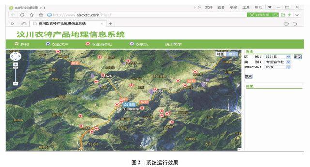
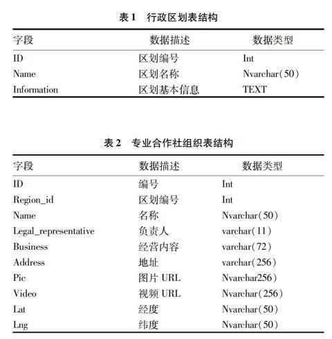

摘要构建农特产品网络地理信息系统,对加强农产品宣传展示、满足消费者知情权利、提高生产者经营水平等具有重要意义。该研究以四川省汶川县为例,构建了基于百度地图API的农特产品地理信息系统,介绍了系统的设计方案和实现技术路线,并对数据库设计、系统开发关键技术及实现效果进行了详细阐述。
关键词百度地图API;农特产品;LAMP;地理信息系统
中图分类号S126文献标识码A文章编号0517-6611(2015)05-342-03
Design and Implementation of Geographical Information System for Agricultural Products Based on Baidu Map API
ZHANG Qian1, JIN Yun-tong2, LUO Yong3 et al
(1.Natural Resources & Science and Technology Information Research Institute of Aba, Aba, Sichuan 623000; 2. Kunming Uion Science and Technology Co. Ltd., Kunming, Yunnan 650051; 3. Sichuan Provincial Academy of Natural Resources Sciences Research, Chengdu, Sichuan 610015)
AbstractBuilding the web geographical information system for agricultural products, plays an very important role to strengthen the agricultural products publicity show, meet the consumers right to know, and improve the management level of producers. Taking Wenchuan County of Sichuan Province as an example, a geographical information system for agricultural products based on Baidu Map API was constructed. The design scheme of system was introduced and the technology route was realized, the design of the database, key technologies of the system were elaborated.
Key wordsBaidu Map API; Agricultural products; LAMP; GIS
基金項目四川省科技支撑计划项目(阿坝州城乡统筹信息平台)。
作者简介张倩(1974- ),女,回族,四川金川人,助理研究员,从事自然资源与科技信息研究。
收稿日期2014-12-24
近年来,随着经济发展水平和生活质量的提高,人们对农特产品的需求越来越大,对其产地、质量、安全要素日益关注。面向主要农特产品的生产、销售、管理,应用先进的计算机技术,对农特产品进行宣传、展示,为消费者提供可靠的相关信息,对提高农特产品的管理水平,加强相关部门监管能力,满足消费者知情权利,提高生产者经营水平,提升农特产品的市场竞争力具有重要作用。农特产品相关信息都具有显著的地理位置特性,而当前快速发展网络地理信息技术(WebGIS),以其强大的空间数据管理与分析、属性数据查询等功能,以及信息动态实时更新、图文并茂、形象直观表达的优势[1-2],为搭建农特产品地理信息系统提供了强有力手段。传统的网络地理信息系统建设过程复杂、维护成本较高,百度地图API技术适用于构建中小型WebGIS。……
登录APP查看全文
猜你喜欢
中华诗词(2022年6期)2022-12-31 06:41:24
Defence Technology(2020年4期)2020-07-02 03:16:58
青年与社会(2018年2期)2018-01-25 15:37:06
中国科技论坛(2017年7期)2017-07-25 08:49:53
财经(2017年2期)2017-03-10 14:35:35
财经(2016年15期)2016-06-03 07:38:02
财经(2016年3期)2016-03-07 07:44:46
财经(2016年6期)2016-02-24 07:41:51
IT时代周刊(2015年8期)2015-11-11 05:50:22
太空探索(2014年4期)2014-07-19 10:08:58
