新生代中国天山北侧的变形过程及其对山体生长的指示意义
2018-11-05 05:16涂宏志崔建新李乐意
地球环境学报 2018年5期
常 宏,涂宏志, ,崔建新,李乐意,
1.中国科学院地球环境研究所 黄土与第四纪地质国家重点实验室,西安 710061
2.中国科学院大学,北京 100049
3.陕西师范大学 西北历史环境与经济社会发展研究院,西安 710062
The Tian Shan orogenic belts provide an ideal setting to understand growth, erosion, sedimentation process and their correlations with the deformation of strata in response to Indo-Asia collision (Tapponnier and Molnar, 1979; Molnar et al, 1993; Charreau et al,2009; Li et al, 2011). Although it is located in the territory of more than 1000 km north of the suture between India and Asia (Fig.1), the crustal thickening and shortening that gave rise to the Tian Shan have accommodated part of India’s total penetration into Asia (Molnar and Tapponnier, 1975; Avouac et al, 1993; Allen et al, 1994; Abdrachmatov et al,1996). The ancestral Tian Shan was built when the Precambrian Tarim block collided with Siberia in the Late Paleozoic (Zhang et al, 1984; Allen, 1993); the relief associated with the orogenic system was eroded by the Cenozoic Era (Allen, 1994; Bullen et al, 2001;Sobel et al, 2006). The India/Asia collision in the Early Paleogene has produced widespread thrusting system in the Tian Shan, and which in turn is responsible for the formation of active foreland basins on the southern and northern margins of the range and intermontane basins within the range itself (Bullen et al, 2001; Zhang,2004; Sobel et al, 2008; Lin et al, 2015). Abundant evidence for thrust faulting throughout the present Tian Shan indicates that the present range was built by crustal shortening and thickening (Burtman, 1975;Windley et al, 1990; Molnar et al, 1994; Deng et al,2000; Delvaux et al, 2001; Fu et al, 2003; Dill et al,2007; Sobel et al, 2008), located in central Eurasia and accommodating as much as ~ 40% of the presentday amount of shortening between India and Siberia(Abdrakhmatov et al, 1996). The Tian Shan range is one of the youngest (< 25 Ma) and highest (>7000 m)ranges in the world (Zhao et al, 2003). It provides a natural laboratory for studying intracontinental deformation and mountain building processes.
Many works have focused on the uplift of the Tian Shan from west to east (Bullen et al, 2001, 2003;Thompson et al, 2002; Bowman et al, 2004; Sobel et al,2006, 2008; Tychkov et al, 2008). The shortening of rock formations has been well studied by using balanced sections and GPS data (Deng et al, 2000).The topographic history of Tian Shan in the Cenozoic and the link between its shortening and the deformed sediments, however, remain poorly understood. The northern margin of the eastern Tian Shan is seismically quite active, recorded two earthquakes with Ms > 8 since 1990, and there have been several earthquakes with body wave magnitudes ≈ 6 since 1965 (Nelson et al, 1987).Almost all of the earthquakes that occurred 10 — 25 km below the Tian Shan were reverse-faulting earthquakes with fault planes parallel to the Tian Shan Mountains(Molnar and Ghose, 2000). Their fault plane solutions also reveal that the principle compressional stress axis is nearly horizontal, whereas the extensional axis is nearly vertical, which indicates that the crustal shortening is horizontal (Molnar and Ghose, 2000). The contraction observed on the surface may persist throughout the lithosphere or at least in the major part of the crust of the Tian Shan (Deng et al, 2000; Zhang, 2004).
Nevertheless, studies of the mechanisms of tectonic deformation processes and mountain building on the Chinese Tian Shan are still scarce. In this study, we place constraints on the style and magnitude of the surface growth and topographic evolution of the Chinese Tian Shan, based on geomorphologic relief, deformation of the Mesozoic and Cenozoic and neotectonic movements supported by other studies. In particular, we report calculated surface growth for deformation basins and evolution of the northernflank of the East Chinese Tian Shan.
1 Regional setting
Fault plane solutions, satellite image studies and field mapping of tectonic features reveal a pattern of compressional deformation in the Tian Shan and in a broad swathe of ranges surrounding the Tibetan Plateau(Dewey et al, 1988). The Tian Shan has been built largely by northward thrusting on relatively steep thrust faults (Molnar et al, 1994). It separates the Junggar Basin from the Tarim basin; in these basins, more than 6000 m of sediments have been deposited along both margins since the Cenozoic (Wang and Yan, 1987; Allen 1994). As a result, thick sediments also reveal that the intense tectonic movement and erosion in the Tian Shan which produced during the Cenozoic.
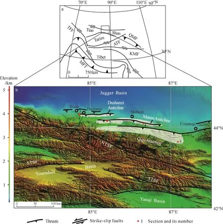
Fig.1 Geological map showing that the present Tian Shan range is an intracontinental deformation region formed in response to collision of India and Asia (a), this map is mainly modif i ed from Allen et al (1994) and Yin et al (1998); morphotectonic map in mainly modif i ed from Deng et al (1999), Lin et al (2002) and Sun and Zhang (2009) based on the DEM of the region (b)
Three parallel rows of anticlines extend for about 300 km along the northern edge of the Eastern Tian Shan (Figs.1, 2), called after the Qigu, Manas, and Dushanzi anticlines. Those in the row closest to the Tian Shan has exposed the oldest rocks, commonly Mesozoic but in some places late Paleozoic, sedimentary and volcanic rocks with rare evidence of intrusive (Avouac et al, 1993; Molnar et al, 1994). This active region induced by E—W-striking folds and thrust faults zone controls the drainage system in front of the northern margin of the Eastern Tian Shan. The southernmost zone (Qigu anticline), along the range front, mostly involves in some sediments as old as Mesozoic; it is an anticline passes along strike eastwards into a southwarddirected thrust that can be traced in the field and on Landsat images for about 80 km along strike (Avouac et al, 1993; Allen et al, 1994). The central zone (Manas anticline) is made up of three linear sub-anticlines(Huoerguosi, Manasi and Tugulu) and associated with thrusts, and stretches east-west for about 150 km with an elevation of 1000 — 1500 m at a distance of 30 —40 km north of the Tian Shan. These three sub-anticlines are asymmetrical with steep or overturned northern limbs and gentle southern limbs, and no formation older than the upper Mesozoic crops out at their core (Avouac et al, 1993; Deng et al, 1996). The northernmost zone(Dushanzi) is composed of three linear sub-anticlines(Dushanzi, Halaande, Anjihai) and associated thrusts.It folds Neogene and Quaternary deposits, and is about 75 km long. In addition, the Wusu uplift is present in the north of the Dushanzi anticline, for which only a slight uplift can be observed on the surface. This uplift becomes the north-verging anticline below the surface(Deng et al, 1999).
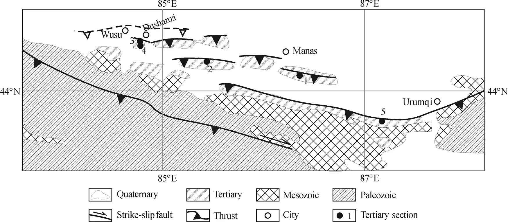
Fig.2 Schematic geological map in Northflank of the Eastern Tian Shan Mountains mainly modif i ed from Avouace et al (1993) and Deng et al (1999), together with our field investigations showing main structure, stratigraphy and tertiary section location
The Qigu anticline is actually composed of several left-stepping folds, with overlapping hinges exposed mostly in Miocene sandstone. The sandstone beds strike N100° — 110°E and dip generally 60° — 65° towards the north. On the west end of this anticline, south-dipping thrust faults offset folds in the Miocene. North-dipping strata appear to follow most of the steep north slope of the mountain.
The three sub-anticlines of the Manas anticline have simple, uniform structures. These anticlines are clearly outlined by Paleogene—Neogene beds (such as the Anjihai, Shawan, Taxihe, and Dushanzi Formations)and the lower Quaternary conglomerates (Xiyu Formation). All three sub-anticlines are asymmetrical,with incomplete steep northern limbs. The fact that the northern limbs of the Huoerguosi and Manas subanticlines barely outcrop between Jinggou River and Manas River implies that thrusts offset their hinges(Avouac et al, 1993). The geometry of the Tugulu anticline indicates that a fault ramping through its core has thrust the southern limb onto the northern limb(Sun and Zhang, 2009). The Tugulu thrust plane strikes N90° — 105°E and dips 50° — 70° to the south. In the field, steeply north-dipping Neogene beds are visible in the hanging-wall of the thrust. The Paleogene—Neogene beds are tightly folded into a small sub-anticline.
The Dushanzi anticline is outlined by the Neogene (e.g., Taxihe and Dushanzi Formations)and lower Quaternary (Xiyu Formation). In field investigations, the thrust was found in the northern limb of the Dushanzi sub-anticline, and its core has thrust onto its northern limb. Approaching the core of the anticline from the south, the Xiyu Formation beds areflat-lying, then progressively folded with dips reaching 38°, before becoming horizontal at the heart of anticline (Charreau et al, 2005). The dip direction and dip angle of the strata in the southern limb of the Dushanzi sub-anticline are uniformly 200° — 205° and 30° — 34°, respectively, except that the upper Xiyu Formation has a growing stratum dipping upwards from 30° to 5° (Sun et al, 2004).
2 Strata folded in anticlines
2.1 Qigu anticline
The oldest strata folded in the Qigu anticline was formed during middle—upper Jurassic (Fig.2 section 5), which is up to 3100 m thick and comprises the Totunhe, Qigou, and Karazha Formations (Wu, 1986;Chen et al, 1991). The Cretaceous is composed of the Hutubi, Shengjinkou, Lianmuqin, and Donggou Formations; it is up to 1900 m thick and is conformable with the Jurassic underneath (Wu, 1986; Chen et al, 1991; Avouac et al, 1993). The stratum from Paleocene—Eocene to Oligocene is composed of the Shawan, Zhiniquan and Anjihaihe Formations,and reaches up to 1400 m thick. The Neogene(Taxihe and Duanshanzi Formations) is up to 2800 m thick (Wu, 1986). The Quaternary conglomerates (Xiyu Formation) reach a thickness of 2400 m. The deformation features, dip directions and angles of the strata vary in different parts of the Qigu anticline. However, in the Santunhe section of this anticline, the growth strata include the Taxihe, Dushanzi, and Xiyu Formations(Fig.3). Unconformity between Jurassic and Cretaceous and its deformation indicate tectonic event before Cretaceous. The dip variation in Cretaceous reveals its uplift after sedimentation. The thickness of all of the pregrowth Cenozoic strata reaches up to about 1400 m.
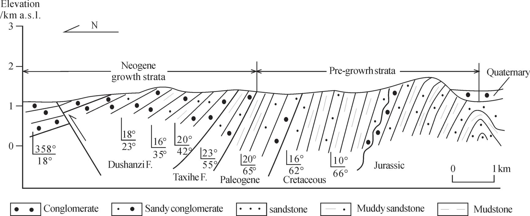
Fig.3 Mesozoic—Cenozoic strata in the Qigu anticline showing the pre-growth and growth strata,modif i ed from Deng et al (1999) and Guo et al (2006a), together with our investigation in the field
2.2 Manas anticline
The strata folded in the Manas anticline include Oligocene (Aijihaihe Formation), Neogene (Shanwan,Taxihe, Duanshanzi Formations) and Quaternary (Xiyu Formation) rocks (Fig.4). The Anjihaihe Formation is up to 200 m thickness in the Huoerguosi subanticline of the Manas anticline. The Shanwan, Taxihe,Dushanzi, and Xiyu Formations are about 520 m, 550 m,1180 m, and 1700 m of thickness in the Huoerguosi sub-anticline (section 2) (Ji et al, 2008), and 290 m,1740 m, 620 m, and 2000 m of thickness in the Tugulu sub-anticline (section 1) (Sun and Zhang, 2009),respectively. In the south limbs of the Manas anticline,the dip directions and angles of the pre-growth strata are simple, uniformly 175° and 55° in section 2, and 190° and 60° in section 1. The growth strata include the Dushanzi and Xiyu Formations, which dip angle change gradually upward from 75° to 10° in section 1, whereas they include only the Xiyu Formation in section 2, where the dip angle gradually changes upward from 53° to 5°. Although the growth strata are named differently by geologists (Ji et al, 2008; Sun and Zhang, 2009) in the Huoerguosi and Tugulu subanticlines, the ages of the bottom of the growth strata are similar: 6.6 — 6 Ma. Namely, the growth strata that contributed to the thrusting event were coinstantaneous.
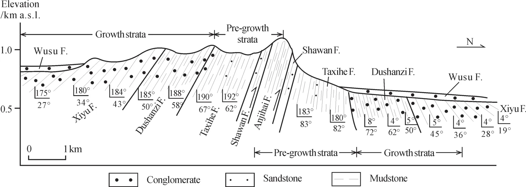
Fig.4 Cenozoic strata in Tugulu sub-anticline, part of the Manas anticline, showing growth strata that include both the Dushanzi formation and the Xiyu formation. Modif i ed from Deng et al (1999) and Sun and Zhang (2009), together with our investigation
2.3 Dushanzi anticline
The Taxihe, Dushanzi, and Xiyu Formations were folded when the Dushanzi anticline developed (Fig.5).The Taxihe and Dushanzi Formations are up to 1600 m and 1300 m of thickness, respectively, in the Dushanzi section (section 4) (Sun et al, 2004), whereas they are up to 1559 m of thickness in the Kuitunhe section (section 3)(Charreau et al, 2005). The dip directions and angles are 200° — 205° and 27° — 34° in section 4, and 195° and 38°in section 3. The upper Xiyu Formation represents growth strata in two sections in which the dip changes gradually from 35° to 5°. The age of the base of the Xiyu Formation is 4.8 Ma in section 5 and 4.2 Ma in section 4 (Sun et al,2004; Charreau et al, 2005).
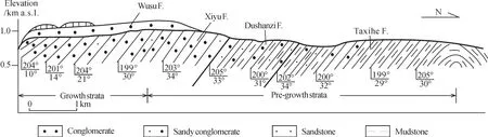
Fig.5 Neogene strata in Dushanzi sub-anticline showing that growth atrata including the Upper Xiyu Formation. This map mainly modif i ed from Sun et al (2004), together with our investigation
3 Uplift and shortening
Because the changes of dip angle of growth strata are influenced by sedimentary processes, temporal morphography and thrust faulting (Panel of the Geodynamics of Sedimentary Basins and National Research Council, 1997), it is difficult to estimate the uplift and shortening only on their information gained in field. However, beds of pre-growth strata are deformed only by thrusting events, on the assumption that they were level in the course of sedimentation(Sun and Zhang, 2009). The uniform dip angles of pre-growth strata in sections 1, 2, 3, 4 and 5 reveal that they are constant in the sedimentary process, and combined with their relatively fine-grained size, they may well have been level before the thrusting events.We have simply calculated the uplift and shortening according to data about these four sections in three row anticlines on the northflank of the East Tian Shan as follows (Fig.6):
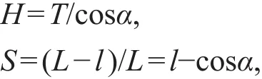
here, H is the height of uplift; T is the thickness of the pre-growth strata; S is shortening ratio of the rock, L is the outcropping length of the pre-growth strata; α is dip angle, and l is the length of the shortened pregrowth strata.
Fig.6 Relationship between the uplift elevation (H ) and thickness (T ), dip angle (α) of deformed pre-growth strata
3.1 Duanshanzi anticline
The maximal outcropping thickness of pre-growth strata is about 1180 m in section 4 in the Dushanzi anticline, and α is 38°. The H is about 1497 m, and S is about 0.21. The thickness of the pre-growth strata in section 3 is about 1120 m, and α is 34°, so H is about 1351 m, and S is 0.17. The distance from the north end to the south end of the Dushanzi anticline is about 10 km, so the Dushanzi section should have been shortened by about 2.0 — 2.7 km due to the thrusting event. This fits with the result estimated by Burchf i eld et al (1999) on the basis of a balance cross section,by the methods it has been estimated that the strata shortened by 2 — 2.5 km. The average width of the Chinese Tian Shan is about 200 km, if shortening is similar in whole range, the shortening should reach 41 — 53 km. This result also fits with the result (29 km)estimated by Deng et al (2000) on the basis of the method of balanced section and result (38 km) by Avouac et al (1993) on the basis of modeling.
3.2 Manas anticline
Because the pre-growth strata overturn in the northern limb of the Tugulu sub-anticline, it is complicated and difficult to estimate the uplift, so we calculate related values according to the geological information in the Huoerguosi sub-anticline. The thickness of the pre-growth strata is about 1270 m in the Jingouhe section, and α is 55°. The H is about 2214 m, and S is about 0.43. The Jingouhe section has been shortened by about 7.5 km due to the thrusting events since the Late Miocene.
Because the early thrusting event is imprinted by the later one, the last shortening includes the deformation of the pre-growth strata in the Dushanzi anticline and S is 0.21. S is 0.22 including only the thrusting that folded and faulted the pre-growth strata in the Manas anticline, after removing the influence of the later tectonic folding and thrusting of the Dushanzi anticline. In the same way, the uplift was about 800 m during the formation of the Manas anticline before the onset of the Dushanzi anticline.
3.3 Qigu anticline
The dip direction and angle varied in different parts of Qigu anticline. We calculate the uplift and shortening by using only the deformed Cenozoic strata from the Santunhe section (Fig.3). H is about 3000 m,and S is about 0.53. If this is actually denoting the shortening ratio of the Tian Shan, the amount of distance shortened would reach about 230 km. This is in the middle of previous data 120 km (Molnar and Tapponnier, 1975; Avouac et al, 1993; Allen et al, 1994) and 280 km (Chen et al, 1991). Dewey et al (1989) even estimated that the shortening distance is about 350 km between the eastern Tian Shan and Altai. If out date is right, H is about 800 m, and the shortening ratio was about 0.10 by folding and thrusting in the Qigu anticline during the early the Late Oligocene—the Early Miocene.
The present mean elevation of the Tian Shan is about 4000 m. Metivier et al (1997) reconstructed the mean paleoelevation in the early Miocene at about 1100 m by a mass balance model to the Tarim and Junggar basins. If this result is the case, the total surface uplift of the Tian Shan is about 2900 m since the early Miocene. Our calculated surface uplift is about 3000 m, which is similar to the results determined by the mass balance model of Métivier and Gaudemer (1997).
4 Discussion
Cenozoic compression contributing to the Eocene collision between India and Asia reactivated older faults as thrusts to build the present Tian Shan(Windley et al, 1990; Allen et al, 1993; Thompson et al,2002; Dickerson et al, 2003). The tectonics of the Paleozoic and Mesozoic is therefore very important to the Cenozoic tectonics.
4.1 Tectonic history of the Tian Shan
The Tian Shan records two Paleozoic collisional events (Windley et al, 1990; Allen et al, 1991; Gao et al,1998; Chen et al, 1999; Zhao et al, 2003). The first event involved in the collision of the Tarim block with the central Tian Shan along the southern margin of the range in the late Devonian—early Carboniferous(Allen et al, 1991; Gao et al, 1998; Chen et al, 1999).The second event was in the late Carboniferous—early Permian, when the northern Tian Shan arc was accreted onto the northern margin of the combined Tarim—central Tian Shan continental block (Windley et al, 1990; Avouac et al, 1993; Zhao et al, 2003).Beginning from the early Permian, the Tian Shan entered its intraplate tectonic development phase.
Considerable evidence reveals that the Tian Shan underwent multiple episodes of deformation during the Mesozoic (Hendrix et al, 1992, 2000; Allen et al, 1993;Cogne et al, 1995; Burtman et al, 1996). Hendrix et al(1992) presented several pulses of conglomerate deposition that contributed to regional source area uplift at those times on the basis of a detailed study of the stratigraphy of Mesozoic formations in the Junggar and Tarim basins. The unconformity between the Late Jurassic and the Early Cretaceous on the northernflank of the Tian Shan (Sun et al, 2004) also shows that the range was uplifted at that time. The Tian Shan was exhumed a modest amount in the Jurassic, according to the results of paleogeographic reconstructions for the Jurassic; after that, a less-active tectonic regime prevailed until the collision between India and Asia in the early Tertiary (Bullen et al, 2001).
The Tian Shan remained tectonically inactive for much of the Late Cretaceous and Paleogene,until the Late Oligocene. Stratigraphic deformation,cooling ages and geodesy have been interpreted to provide a wide variety of ages for the initiation of the Late Cenozoic Mountains building in the Tian Shan(Hendrix et al, 1992; Sobel et al, 2006; Wei et al,2013). Conglomerate deposition above unconformity in late Oligocene—early Miocene could be used to loosely bracket the onset of synorogenic deposition in the Tian Shan (Windley et al, 1990; Allen et al, 1993),although the age of the unconformity remains poorly resolved. The facies transition between lacustrine and braided-fluvial sequences also shows that thrusting in the southern flank of the Tian Shan may have initiated at 21 — 24 Ma (Yin et al, 1998). Structural deformation has encroached into the Tian Shan foreland since the Early Miocene in response to the ongoing Indo-Asian collision (Heermance et al, 2008).Thermochronologic evidence from the Chinese Tian Shan also indicates the initiation of deformation in the Early Miocene (Hendrix et al, 1994; Yang et al, 2003;Liu et al, 2004; Guo et al, 2006b; Sobel et al, 2006).
Estimation of total shortening near Urumqi(Avouac et al, 1993) and extrapolation geodetically determined modern shortening imply that the Tian Shan was constructed in recent 10 Ma (Abdrakhmatov et al,1996). Offset and slip velocities of the Talas-Ferghana fault imply that an initiation of slip is more recent than about 10 Ma after the India-Asian collision (Burtman et al, 1996). The difference between the Oligocene—Miocene initiation of important exhumation from evidence of the thermochronology and stratigraphy deformed and the Late Miocene initiation estimated from the geodesy suggests that slip velocity must be varied over time and the Tian Shan has been undergoing a complex Late Cenozoic shortening history.
Thermochronologic and stratigraphic evidence also suggest that the Chinese Tian Shan also record an exhumation and uplift event at 10—8 Ma (Liu et al,2004; Guo et al, 2006b; Ma et al, 2006; Zhu et al,2006; Zhang et al, 2007; Ji et al, 2008; Sun and Zhang,2009) and since 4 Ma (Fu et al, 2003; Sun et al, 2004;Charreau et al, 2005). These two tectonic uplifts also occurred in the western (Burtman et al, 1996; Bullen et al, 2001, 2003; Sobel et al, 2006, 2011; Heermance,2008; Zhang et al, 2013; Chen et al, 2015) and southernflanks of the eastern Tian Shan (Fu et al, 2003; Wang et al, 2003; Charreau et al, 2006; Huang et al, 2006;Zhang et al, 2014; Qiao et al, 2016; Yang et al, 2016).Thermochronological and stratigraphic data from the Chinese Tian Shan reveal several phases of differential folding and cooling events since the Early Miocene,possibly in pulsed-northward migrating events.
4.2 Range building of the Chinese Tian Shan
The period between the Last Mesozoic collision and initiation of Cenozoic deformation in the Tian Shan (~25 Ma) was a time of tectonic quiescence.During this period, the ancestral Tian Shan was beveled by erosion and a decrease of local relief during the Paleogene (Burtman et al, 1975; Bally et al,1986; Sobel et al, 2006). Most of the elevation of the Chinese Tian Shan is the result of uplift since the Late Oligocene —Early Miocene. The north-south crustal shortening and thickening occurs across the entire width of the orogenic belt and is fulf i lled by thrusting and slipping on many thrust fault (Molnar, 2015).
In Qigu anticline, the oldest growth strata are from the Taxihe Formation, which was deposited since the Early Miocene according to the lithostratigraphy evidence on the northern flank of the Tian Shan (Ji et al, 2008; Sun and Zhang, 2009). This formation is accompanied by the same age unconformity (Windley et al, 1990; Allen et al, 1993), and exhumation of this region was identif i ed by employing thermochronology(Hendrix et al, 1994; Yang et al, 2003; Liu et al, 2004;Guo et al, 2006b; Sobel et al, 2006; Macaulay et al,2013). This evidence suggests that thrusting occurred in the northern margin of the Mountains in the Early Miocene and made it develop toward the Junggar basin. Synchronously, The Qigu anticline began to develop, and its southern limb, perhaps including the rest of the Eastern Tian Shan, thrust over its northern limb (Fig.7a, 7b). The mean paleoelevation of the Eastern Tian Shan was about 1800 m. Most of the Western Tian Shan was inactive (Bullen et al, 2001;Sobel et al, 2006), and tectonic movement only occurred in its middle part and the southern flank of the Western part (Heermance et al, 2008; Chen et al,2008; Tang et al, 2016).
The oldest growth-strata in Manas anticline were deposited since about 6.6 Ma in the Huoerguosi sub-anticline (Ji et al, 2008) and 6 Ma in the Tugulu sub-anticline (Sun and Zhang, 2009). Even though depositional systems in the piedmont belt may be stratigraphically sensitive to discrete changes, there is a lag between the uplift of the range and consequent sedimentation in the basin (Yin et al, 2002; Lease et al,2007). The thrust developed by the Manas anticline therefore may have become actively since 10 Ma, as is identified by thermochronological data (Liu et al,2004; Guo et al, 2006b; Ma et al, 2006; Zhu et al, 2006;Zhang et al, 2007). This period of tectonic movement also occurred in the rest of the Tian Shan (Sobel and Dumitru, 1997; Bullen et al, 2001; Heermance et al,2008) and the whole Tibetan Plateau (Molnar, 2005;Molnar and Stock, 2009). The mean paleoelevation of the Eastern Tian Shan was up to about 2600 m after this movement.
When the middle-upper part of the Xiyu formation was deposited, the thrust developed by the Dushanzi anticline was active. Thick growth strata(3800 m) in the Duanshanzi anticline suggest that the thrust was very strong at that time. This period tectonic movement is occurred in a broad region in the northern parts of the Tibetan Plateau, including the Kunlun Mountains (Zheng et al, 2000, 2003;Wang et al, 2003), the North Mountain (Fang et al,2007), the Qilian Mountains (Li, 1991; Fang et al,2005) and other parts of the Tian Shan (Bullen et al,2001; Fu et al, 2003; Charreau et al, 2005). The mean paleoelevation of the Eastern Tian Shan was up to about 4000 m, which is nearly up to its present elevation (Fig.7d).
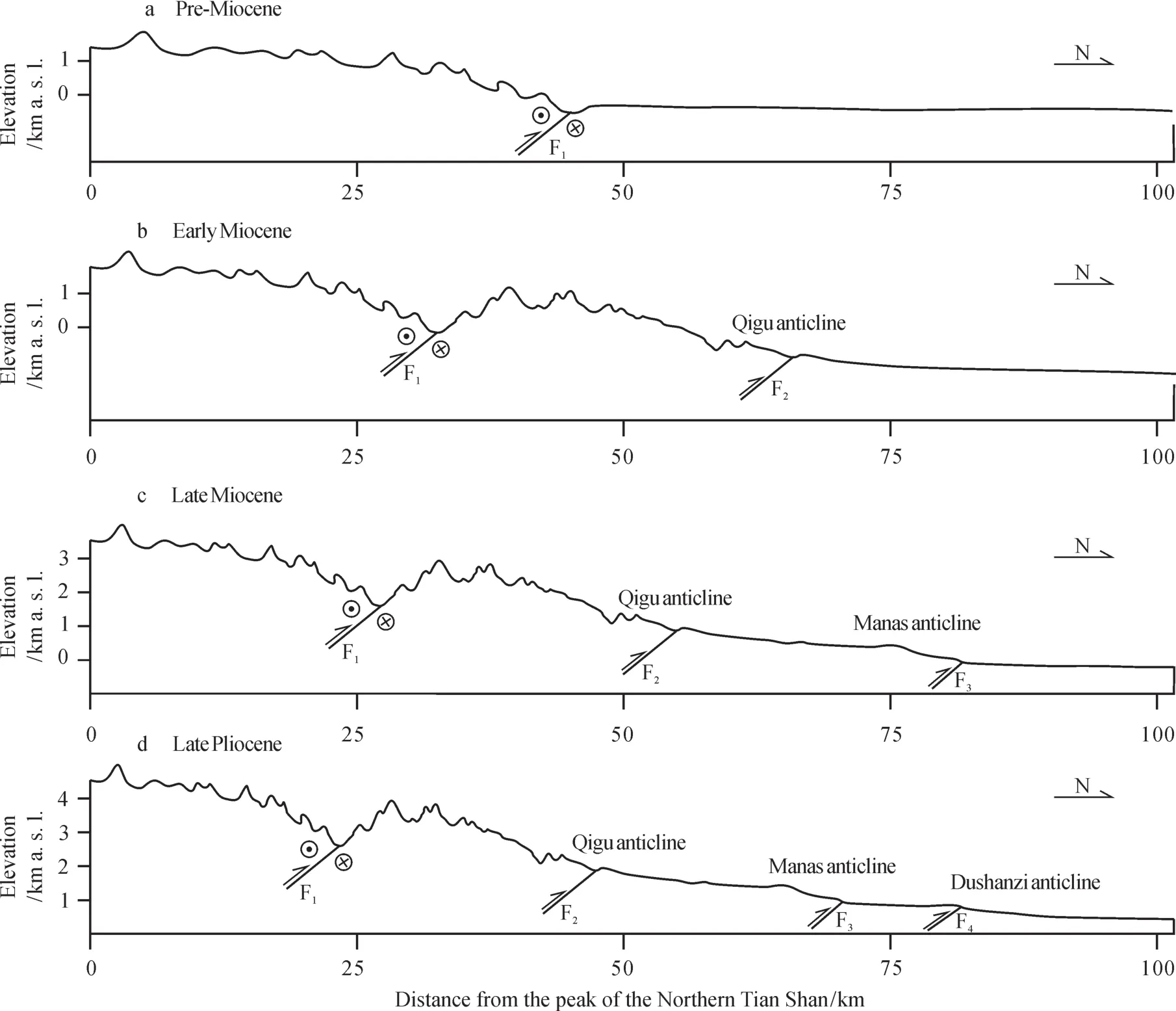
Fig.7 Schematic evolution of the northflank of the Eastern Tian Shan Mountain since Late Cenozoic
The uplift of Wusu shows that the shortening between the Tian Shan and Junggar basin is continuing at present (Deng et al, 1999). The ranges surrounding the Naryn basin initiated at least 1—4 Ma in Kazakhstan which support this result (Goode et al,2014). Recent study also conf i rms that the Tian Shan range remains topographic growing on the base of the observation (Charreau et al, 2017), that coincide with result of field analysis (Molnar and Ghose, 2000). The Chinese Tian Shan would uplift persistently in the future. The thrust system has not only impacted on the uplift of the ranges during the Neogene, but also resulted in development of the Cenozoic sub-basin in the Junggar basin.
5 Conclusions
The three parallel rows of anticlines progressively produced at 24—20 Ma, 10—8 Ma, and since 4 Ma,and gradually prompted upspring of the Chinese Tian Shan. These events accelerated erosion and deformation of the northern margin of the Eastern Tian Shan since the Early Miocene and resulted in the huge thickness of Cenozoic units in the Junggar basin and Tarim basin on both sides of the Tian Shan (Wang and Yan, 1987; Allen, 1994). In particular, synchronous uplift of the Eastern Tian Shan made it becoming a magnif i cent range. On the basis of structural geology,stratigraphy, and thermochronologic data, in summary,we infer that the growth of the Eastern Tian Shan has been shown by its episodic uplifts since the late Cenozoic; and is also controlled by fault thrusting along the northernflank of the eastern Tian Shan, this kinds of tectonic deformation are commonly existed in whole Tian Shan (Delvaux et al, 2013) and in the Tibetan Plateau (Li et al, 2012); and has been moving from south to north (outward from the Tian Shan range to the Junggar Basin).
Acknowledgements: This study was jointly supported by NSFC (41420104008, 41572166), and CAS(QYZDY-SSW-DQC001 and XDB26000000). Authors are grateful to reviewer who improved English in this paper.
猜你喜欢
纺织学报(2022年8期)2022-08-26
好日子(2022年6期)2022-08-17
好日子(2021年8期)2021-11-04
意林·全彩Color(2019年11期)2019-12-30
小学生学习指导(低年级)(2016年12期)2016-12-13
小学生学习指导(高年级)(2016年12期)2016-12-13
民族音乐(2016年4期)2016-12-06
吐鲁番(2014年2期)2014-02-28
文化交流(2009年10期)2009-05-28