
基于Landsat影像的玉溪市红塔区土地覆盖分类及变化分析
2019-06-07 07:22:54陈仙春赵俊三陈磊士陈国平
森林工程
2019年3期
陈仙春 赵俊三 陈磊士 陈国平
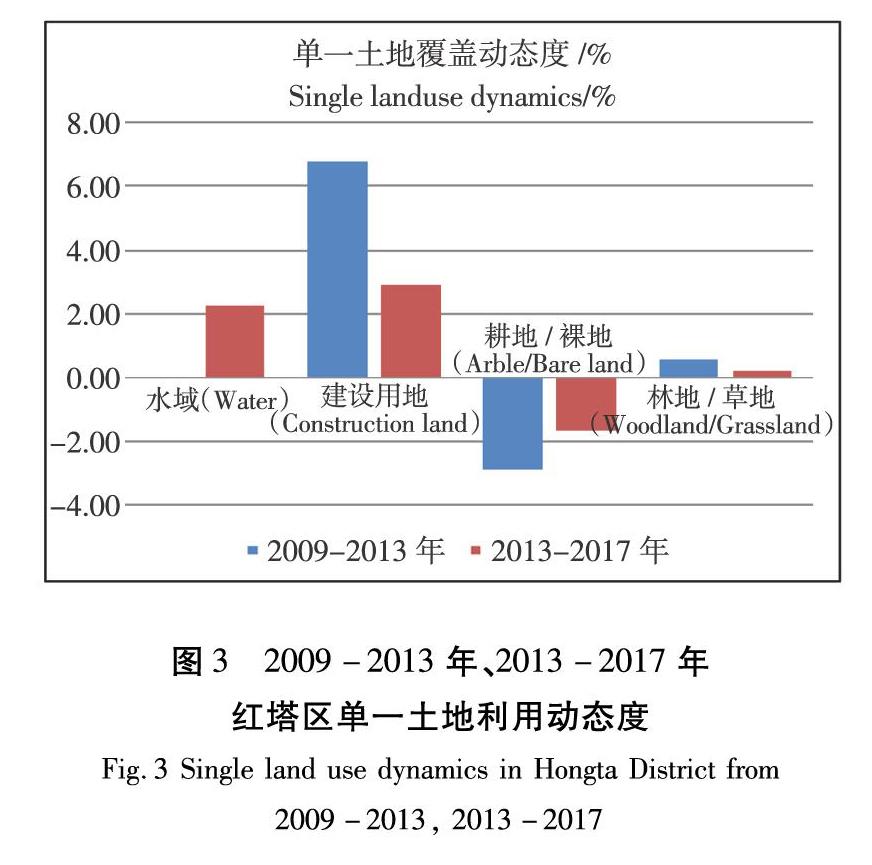
摘要:本文以玉溪市红塔区为例,基于2009年、2013年和2017年的Landsat遥感数据,采用支持向量机(SVM)及人工解译的方法获取对应的土地覆盖分类结果,其分类精度均达到80%以上,滿足变化分析的需求。根据分类结果使用土地覆盖比例、土地覆盖变化幅度、土地覆盖转移矩阵以及土地覆盖动态度共4项指标,对红塔区2009年到2017的土地覆盖变化进行分析。结果表明:①耕地/裸地的覆盖比例减少了6.06%,建设用地、林地/草地、水域覆盖比例分别增加了4.36%、1.67%、0.03%;②建设用地和耕地/裸地的变化幅度较大,建设用地增加41.45 km2,耕地面积减少了57.47km2,水域和林地/草地变化较小,分别增加了 0.27 km2和15.76 km2;③两个研究时段的建设用地和耕地/裸地的变化速度均较快,且在第一时段建设用地单一动态度达到6.81%,但后一时段相对于前一时段的综合动态度降低了0.53%,说明后一时段相对于前一时段土地覆盖变化程度得到了减缓。该研究结果为玉溪市红塔区相关部门更加有效地管理土地资源,提供了必要的决策依据。
关键词:Landsat影像;土地覆盖分类;变化分析;红塔区
中图分类号:TP79;F301.24;P23文献标识码:A文章编号:1006-8023(2019)03-0001-08
Land Cover Classification and Change Analysis of Hongta District
in Yuxi City Based on Landsat Image
CHEN Xianchun, ZHAO Junsan*, CHEN Leishi, CHEN Guoping
(Faculty of Land and Resource Engineering, Kunming University of Science and Technology, Kunming 650093)
Abstract:Takeing Hongta District of Yuxi City as an example, the classification accuracy is more than 80% by using Support Vector Machine (SVM) and manual interpretation to get the corresponding land cover classification results based on the landsat remote sensing data of 2009, 2013 and 2017 and, meet the needs of change analysis. Analysis of land cover change in Hongta District from 2009 to 2017,the four indicators including land cover coverage ratio, the extent of land cover change, land cover transfer matrix, and the degree of land cover dynamics, show:①The coverage ratio of cultivated land/naked land decreased by 6.06%, the proportion of construction land, forest land/grassland and water area increased by 4.36%, 1.67% and 0.03% respectively. ②The construction land and cultivated land/naked land have a large change range, the construction land increased by 41.45km2, and the cultivated land area decreased by 57.47km2, and the water area and forest land/grassland changed little, increasing by 0.27km2 and 15.76km2 respectively. ③The construction land and cultivated land/naked land change faster in the two study periods, and the annual change rate of construction land in the first period reaches 6.81%, but the comprehensive dynamic degree of the latter period is relatively lower than the previous period by 0.53%, indicating that the extent of land cover change in the latter period relative to the previous period has been slowed down. The research results provide the necessary decision-making basis for the relevant departments of Hongta District of Yuxi City to manage land resources more effectively.
Keywords:Landsat image; land cover classification; Change analysis; Hongta district
0引言
随着经济的迅猛发展,城市化进程的加快,土地利用的合理规划变得越来越重要,利用遥感进行土地利用变化监测成为现阶段的重要手段。土地利用变化监测[1]是指凭借广域性、周期性和经济性的遥感信息数据源,结合地面辅助资料,借助计算机图像处理技术,对土地利用状况及其动态变化进行全面系统地评估和分析的科学方法。……
登录APP查看全文
