
大运河在中国
2021-10-21 03:05金少策徐露路马克强
文化交流 2021年10期
金少策 徐露路 马克强
大运河又名京杭大运河、南北大运河,始建于公元前486年,包括隋唐大运河、京杭大运河和浙东大运河三部分,总长2700公里。它是中国古代最伟大的水利工程,也是世界上最长的运河,开凿至今已有2500余年历史。
大运河北起北京,经天津、河北、山东、江苏、浙江等省市,贯通海河、黃河、淮河、长江、钱塘江五大水系,通过浙东运河直抵东海,是中国东部沟通内河、联系海港的南北水运交通干线,且兼有灌溉、防洪、排涝之利,更对历代的政治、经济、军事和文化发展、对外交流起到了重要作用。
历史沿革
公元前486年,吴王夫差为争霸中原,利用长江三角洲的天然河湖港汊,疏通了由今苏州经无锡至常州北入长江到扬州的“古故水道”,并开凿邗沟(自扬州向东北,经射阳湖到淮安入淮河)。
公元605年,隋炀帝下令开通济渠。工程西段自今洛阳西郊引谷、洛二水入黄河;工程东段自荣阳县汜水镇东北引黄河水,循汴水(原淮河支流),经商丘、宿县、泗县入淮。通济渠又名汴渠,是漕运的干道。
其后,隋炀帝又开永济渠,引黄河支流沁水入今卫河至天津,继溯永定河通今北京。610年继开江南运河,由今镇江引江水经无锡、苏州、嘉兴至杭州通钱塘江。至此,建成以洛阳为中心,由永济渠、通济渠、山阳渎和江南运河连接而成的大运河,南至杭州,北达北京。
唐时浚河培堤筑岸,以利漕运纤挽,将自晋以来在运河上兴建的通航堰埭,相继改建为既能调节运河通航水深、又能使漕船往返通过的单插板门船闸。宋时将运河土岸改建为石驳岸纤道,并改单插板门船闸为有上下闸门的复式插板门船闸(现代船闸的雏形),使船舶能安全过闸,运河的通过能力也得到了提高。
北宋元丰二年(公元1079年),为解决通济渠引黄河水所引起的淤积问题,进行了清汴工程,开渠50里,直接引伊洛水入汴河,不再与黄河相连。这一工程兼有引水、蓄水、排泄、治理等多方面的作用。
为改善漕运路线,元朝于1282年动工挖济州河,自今济宁引洸、汶、泗水为源,向北开河150里接济水(相当于后来的大清河位置)。济州河开通后,漕船可由江淮溯黄河、泗水和济州河直达安山下济水。其后,又开会通河,长250里,接通卫河。漕船可由济州河、会通河、卫河,在溯白河至通县。
1291年至1293年,元朝从今通县到大都开通惠河,建闸20座。从此,漕船可由通县入通惠河,直达今北京城内的积水潭。至此,今天的大运河的路线走向初步形成。
明、清两代均建都北京,都对元朝大运河进行了扩建。明朝先后在1528—1567年和1595—1605年,自今山东济宁南阳镇以南的南四湖东相继开河440里,使原经沛县、滁州入黄河的原泗水运河路线(今南四湖西线),改道为经夏镇、韩庄、台儿庄入黄河的今南四湖东线,即韩庄运河线。
清朝于1681—1688年,在黄河东侧,约由今骆马湖以北至淮阴开中河、皂河近200里,北接韩庄运河,南接今里运河,从而使运河路线完全与黄河河道分开。
1855年,黄河在河南省铜瓦厢决口北徙,在山东省夺大清河入海,大运河全线南北断航,清朝后期和民国时期,曾几度倡议治理运河,但均未付诸实施。
新中国成立后,于1953年和1957年兴建江阴船闸和杨柳青、宿迁千吨级船闸,开始了对古老大运河的部分恢复和扩建工作。1959年以后,结合南水北调工程,重点扩建了滁州至长江段400余公里的运河河段,使运河单向年通过能力达到8000万吨,并扩大了沿岸灌溉面积和排涝面积,确保里下河地区1500万亩农田和800万人民生命财产的安全,取得了多方面的效益。
目前,大运河济宁以南至杭州河段已建成16座通航梯级,其中大型船闸12座。运河及其沿岸河流、湖泊已节节设闸控制,洪水期调泄,枯水期补给,江水北调工程已取得一定成果。济宁至杭州段的运河扩建续建工程业已开始,将进一步浚深扩宽航道,加建复线船闸,沟通运河至钱塘江的航道,扩大港口吞吐能力。从已建工程效益来看,具有投资少、运量大、成本低、占地少、燃料消耗低的优点。
浙江省境内钱塘江以东的运河是大运河的延伸入海段——浙东运河,西起杭州市滨江区西兴街道,跨曹娥江,经过绍兴市,东至宁波市甬江入海口,全长239公里。
浙东运河是连接陆上丝绸之路和海上丝绸之路的重要纽带,历史最早可追溯到春秋时期越国开凿的山阴故水道。当时,范蠡在会稽山北建成山阴大城(今浙江绍兴古城),作为越国的活动中心。为了便利交通,范蠡主持疏浚了自山阴城东东郭门至今上虞练塘村的山阴故水道。浙东运河的开凿,对后世浙江的水利灌溉和全国性的南北航运、水驿、漕运等都起到了重要作用。
浙东运河是有记载的现存两条先秦古运河之一,至今仍是宁绍平原航运、泄洪、灌溉的主干水道。浙东运河孕育出古越文化:崇尚大禹治水,名士集聚地构建了以兰亭雅集、唐诗之路为高峰的艺术殿堂。
大文化融通
大运河是世界上最长、最古老的人工水道,也是工业革命前规模最大、范围最广的工程项目,它促进了中国南北物资的交流和领土的统一管辖,反映出中国人民高超的智慧、决心和勇气,以及东方文明在水利技术和管理能力方面的杰出成就。可以说,大运河是中国古代人与自然相互顺应、相互改造、相互成就的产物。
毫不夸张地说,大运河文化是一部囊括了中国社会不同历史时期最主要的发展史,其文化也是综合性质的,是中国古代农业创造出来的城市群文化。大运河开凿出了一个新的大环境,把若干小的割据的自然环境贯通成为一个体系,并转化成人文环境。它包括新自然环境、新生态环境、新生产环境、新文化、新物流环境等,形成了发达的“运河社会区域经济”,如古代的“南粮北运”“盐运”通道、现代的“北煤南运”干线、当代的防洪灌溉干流。
大运河文化是民族融合的产物,可分为三个层次:高级文化,包括建筑、文学等;大众文化,指沿途习俗、仪式、衣食住行、生活方式等;深层文化,指价值观取向,即黄河文化延伸出来的那种民族精神,早已渗透在大运河文化深处。
那么,大运河文化作为一种历史悠久、延绵不断的民族文化,与中华民族精神同根同脉。运河高级文化是没落的封建时代的产物,而运河大众文化则植根于运河深层文化里。运河深层文化更以一种习俗或生活方式,凭借着理想的地理位置、优越的经济条件、优秀的人文环境;依旧存活于运河民间、运河文化遗址。
大运河驾驭南北、总揽全国,成为历代王朝大一统局面的政治纽带,维系着中央集权。从隋唐政权北移,直到元明清,大分裂始终未出现,证明了大运河文化的同化作用。
中华民族多元一体文化与大运河文化有着相互推动的关系。大运河在沟通物质交换的同时,大大消除了地域文化的不平衡,以黄河文明为中心,同化融合了多民族的文化差别,也由此把东南文化、岭南文化、江南文化、齐鲁文化、中土文化、江淮文化、黄河文化、燕北文化、西部文化等几乎全都融合在中国传统思想悠久的时空里。
大运河文化是“中国漕运实践中所创造的物质财富和精神财富的总和”。中国古代社会的意识形态以及与之相适应的经济制度和漕运机构,使大运河文化成为意识形态的文化,在古代政治和经济中是有深刻反映的。
运河生产力还促进了运河文化的繁荣,但运河文化具有一定的民族性,并与那个时代的社会主要矛盾相适应。比如元代是蒙古游牧民族建立的中央政权,其不善农耕,以运河便漕运江南之米。再如,北宋灭亡,金进攻南宋,就以运河漕渡粮草。
无论时代变迁,大运河文化,总随着社会物质生产的发展而发展,大运河文化始终保持了发展的连续性、历史的继承性。也正是因为运河生产力发展的连续性,决定了其上层建筑发展的连续性。
经济南移
西晋和东晋之间,为躲避战乱,北方士族带着钱和生产工具往南方跑路,于是有了“衣冠南渡”的说法。其实南渡的不仅是“衣冠”,还有大量的农民跟着去了南方,共同建设幸福家园。
到了南方后,新品种的种植带来了粮食的增产、水利工程的建设,起到了促进生产力发展的作用。相比于战乱四起、征伐不断的北方,南方更为安定,被称为天下粮仓的太湖区域就是在此时茁壮成长起来的。
为了解决北方粮食紧缺问题,隋文帝开始有了贯通南北运河的构想。至隋炀帝,京杭大运河雏形基本完成。大运河的出现,为隋朝以及后来的唐王朝解决了无数的粮食和赈灾问题,也为本可能走下坡路的长安城续写了一段辉煌历史。
通过运河河道,促进了贸易和经济的往来,并且將天下财富和人才源源不断地输送到长安,再加上唐朝对西域的开拓,使得长安成为当时的世界第一城市。
同时,对于南方来说,市场进一步扩大后,商贸业迎来了爆发。南方的锦、镜、铜器、海味、玳瑁、真珠、象牙、沉香、橘子和茶叶等被销往广阔的北方,甚至通过丝绸之路被运往更西边。
唐后期,扬州已经是中国造船业的中心,南昌则是造船基地,唐朝船只的数量和技术都达到了一个前所未有的高度。
北宋时期,稻米技术从越南传入了中国,这项技术进步一定程度上也改变了中国。随着水利的修缮和农耕技术的发展,江南地区在全国的农业生产地位进一步被加强。
手工业生产、矿冶业、纺织业等领域,南方都远远领先北方。作为中国标志性特产的瓷器行业,南方也已赶上北方。浙江龙泉盛产青瓷,有“千峰翠色”的雅号;而江西新平则是全国的产瓷中心,宋真宗景德年间在此建了个官窑,便是大名鼎鼎的景德镇。
到了南宋,宋高宗移都杭州,政治中心和经济重心进一步来到了东南沿海地区,自此,中国经济重心的南移彻底完成。
元朝虽建都北京,但对南方经济的依赖更为严重,利用之前隋唐大运河的部分河段,重点打通了山东区域,形成了现今的京杭大运河。它总共可分为七段,即:北京—通州;通州—天津;天津—临清;临清—台儿庄;台儿庄—淮阴;淮阴—扬州;镇江—杭州。
因此,宋代以后,长江流域特别是东南部地区学校教育兴旺发达,而且总体水平明显高于其他地区,同时具有明显的示范和表率作用。
经济重心南移直接促进了长江流域商品经济的进一步发展与商品化程度的提高,从而催生了新的生产方式首先在江浙一带萌芽并进一步发展。
交流窗口
明清时期的京杭大运河是南北交通的大动脉,不仅促进了南北物资的交流和沿线城镇聚落的兴起,也便利了人员的往来,在中外文化交流中发挥着重要的作用,一些外国使节、传教士、旅行者等多取道于此。
世界著名旅行家马可 · 波罗是第一个向欧洲介绍东方古国的人,他记录下自己在运河城市的游历见闻,在欧洲及世界引发了巨大反响。继他之后,有更多外国人途经“大运河”访问中国各地。
1417年(明永乐15年),菲律宾苏禄群岛上的东王巴都葛叭哈刺,率领340多人到中国进行访问。他们由福建泉州登陆后到达杭州,又沿京杭大运河历时两个半月来到北京。归国途中,东王不幸染上重伤寒于德州不治而亡,从此中国的土地上就有了一座外国国王的陵墓。
明万历年间,意大利传教士利玛窦曾在运河漂流,而让他更感兴趣的便是运河漕运,他详细记载了关于运河的所见所闻:“……中国人喜欢用砖而不用石,供皇宫所用的砖可能是由大船从一千五百英里之外运来的。仅是为此就使用了很多船只,日夜不断运行………”
清乾隆五十八年(1793),大英帝国以给乾隆皇帝祝寿的名义派遣庞大代表团出使中国,这是华夏帝国和大英帝国的第一次正式接触。英国人在北京通州登船,开始了为期33天的运河南下之旅。
运河沿线的水利工程、城镇发展和风土人情,给外国人留下了深刻的印象,这在他们的作品中多有体现。他们的观察与描述无疑有助于加深我们对明清京杭大运河的认识。
15世纪末期由朝鲜人崔溥写成的《源海录》,是明代第一个行经运河全程的朝鲜人的记录,生动形象地展示了当时大运河的交通情形和沿岸风貌,富有史料研究和学术价值。
明中后期的运河沿岸城镇是当时中国商品经济和社会文化最为发达的地区,运河的经济文化往来也是最为繁忙兴盛的。崔溥一行经过运河,留下了对运河经济文化交流和运河沿岸城镇面貌系统而完整的描述。崔溥这样描述杭州:“东南一都会,接屋连廊,连衽成帷,市积金银,人拥锦绣,蛮樯海舶,栉立街衢,酒帘歌模,咫尺相望,四时有不谢之花,八节有常绿之景,真所谓别作天地也。”
策彦周良(1501—1579),号怡斋,是日本京都天龙寺妙智院高僧。他博学多才,通晓汉文,于明嘉靖十八年(1539年)与嘉靖二十六年(1547年)先后两次作为日本遣明使副使与正使奉派入明。他在中国逗留5年多,多次沿着运河北上与南下。策彦周良把两次来华的经历写成记事性的诗文集《初渡集》《再渡集》《入明记》,成为中日关系史上的重要文献。
运河的世界
京杭大运河
京杭大运河是世界上里程最长、工程最大的古代运河,也是最古老的运河之一,与长城、坎儿井并称为中国古代的三项伟大工程,并且使用至今,是中国古代劳动人民创造的一项伟大工程,是中国文化地位的象征之一。
春秋时吴国为伐齐国而开凿,隋朝大幅度扩修并贯通至都城洛阳且连涿郡,元朝翻修时弃洛阳而取直至北京。
大运河南起余杭(今杭州),北到涿郡(今北京),途经今浙江、江苏、山东、河北四省及天津、北京两市,贯通海河、黄河、淮河、长江、钱塘江五大水系,全长约1794公里。运河对中国南北地区之间的经济、文化发展与交流,特别是对沿线地区工农业经济的发展起了巨大作用。
大运河的延伸入海段——浙东运河,西起杭州市滨江区西兴街道,跨曹娥江,经过绍兴市,东至宁波市甬江入海口,全长239公里。浙东运河是有记载的现存两条先秦东古运河之一,至今仍是宁绍平原航运、泄洪、灌溉的主干水道。
苏伊士运河
苏伊士运河于1869年修筑通航,在埃及贯通苏伊士地峡,连接地中海与红海,提供从欧洲至印度洋和西太平洋最近的航线。它是世界使用最频繁的航线之一,也是亚洲与非洲的交界线,是亚洲与非洲人民来往的主要通道。北起塞得港南至苏伊士城,长190公里,在塞得港北面掘道入地中海至苏伊士的南面。
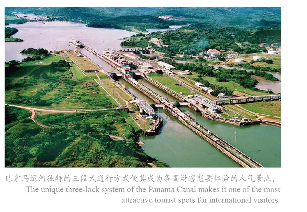
巴拿马运河
1914年通航的巴拿马运河,位于中美洲的巴拿马,横穿巴拿马地峡,连接太平洋和大西洋,是重要的航运要道,是被誉为世界七大工程奇迹之一的“世界桥梁”。巴拿马运河由巴拿马共和国拥有和管理,属于水闸式运河。其长度,从一侧的海岸线到另一侧海岸线约为65公里,而由大西洋(更确切地说是加勒比海)的深水处至太平洋的深水处约为82公里,最宽的地方达304米,最窄的地方也有152米。它是南美洲和北美洲的分界线。
伊利运河
1825年建成通航的伊利运河全长为584公里,整条运河的宽度为12米、深度为1.2米。运河总共有83个水闸,最高可以行驶排水量75吨的平底驳船。伊利运河是第一条提供美国东海岸至西部内陆的快速运输通道。伊利运河不只加快运输的速度,也将沿岸地区与内陆地区的运输成本减少了95%。快捷的运河交通使得纽约州西部更便于到达,因此也促进了美国中西部人口的快速成长。
阿尔贝特运河
阿尔贝特运河是比利时东北部运河。西起马斯河上的列日,东抵斯海尔德河上的安特卫普,长约130公里。最狭处24米,水最浅为5米。1930年始建,1939年完成。可通航2000吨级船只,有6座三厢船闸,在列日的蒙新有一座单厢船闸,借此连接安特卫普和列日两个重要工业区。
莫斯科运河
莫斯科运河修建于1932年,起于杜布纳镇附近的伊万科夫水库,在距离莫斯科河河口190公里的图希诺把后者连接起来。在完成了通往伏尔加河的航道后,于1937年5月1日竣工。1947年前称“莫斯科-伏尔加河运河”,跨越莫斯科、特维尔两州,全长128公里,河宽85米,水深可通航载重5000吨的船只。运河的建成令莫斯科成为“五海之港”,可以乘船到里海、波罗的海、白海、黑海和亚速海。除了航运、旅游用途,运河也为莫斯科带来接近一半的供水。
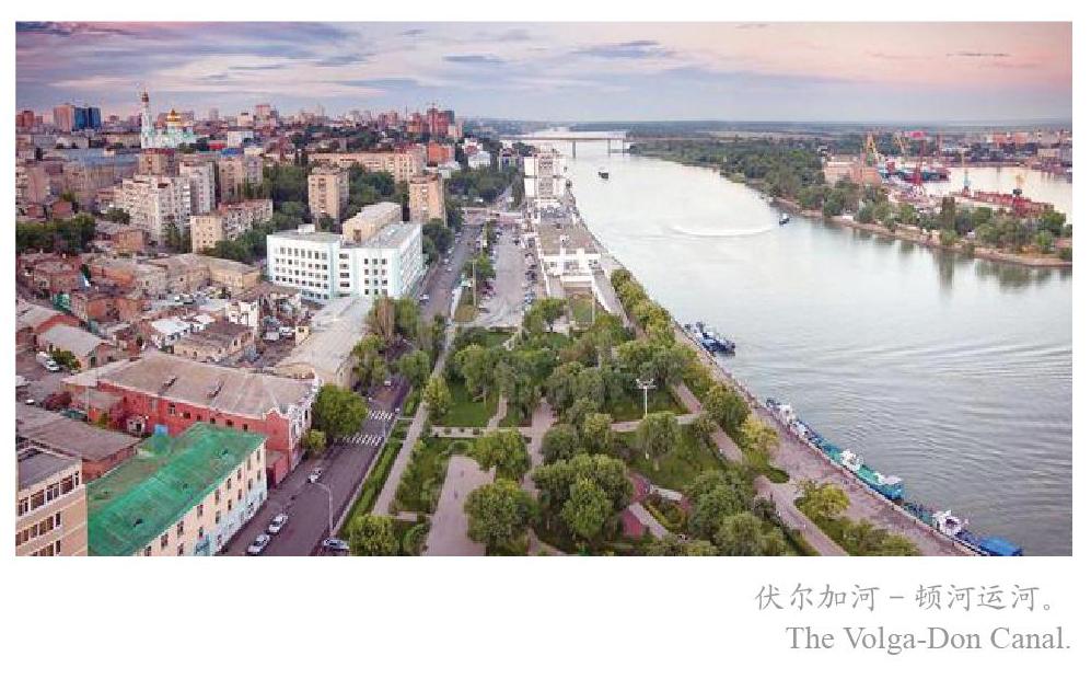
伏尔加河—顿河运河
伏尔加河—顿河运河是连接伏尔加河下游与顿河最终注入亚速海的运河。它位于俄罗斯西部的伏尔加格勒州。1948年开始兴建,1952年竣工。起于顿河齐姆良斯克水库东岸的卡拉奇,止于伏尔加格勒正南方的红军村,长101公里,沿途设有13个船闸,到窝瓦河的落差为88米,到顿河的落差为44米。有卡尔波夫卡、别列斯拉夫卡和瓦爾瓦罗夫卡3个水库,共长45公里。可通行大型内河船只及小型海轮,打开了窝瓦河—卡马河—海的通海航道。
基尔运河
基尔运河又名北海—波罗的海运河,是沟通北海与波罗的海的重要水道。位于德国北部的基尔运河,西南起于易北河口的布伦斯比特尔科克港,东北至于基尔湾的霍尔特瑙港,横贯日德兰半岛,全长53.3海里 ,是连接北海和波罗的海的重要航道,故又名“北海-波罗的海运河”。基尔运河的开通极大地缩短了北海与波罗的海之间的航程,比绕道厄勒海峡-卡特加特海峡—斯卡格拉克海峡减少了370海里。德国修建这条运河,原为避免军舰绕道丹麦半岛航行,建成后,北海到波罗的海的航程缩短了756公里之多。在商业上,现为北海与波罗的海之间安全、便捷和经济的水道。1907年开始对河床进行拓宽和加深工程,于1914年第一次世界大战爆发前几周完成,能通行大型舰船。
约塔运河
约塔运河是瑞典约塔兰的运河,于19世纪初建造。以这条运河为主体的水道途经维纳恩湖和韦特恩湖,延伸至约塔河和特罗尔海特运河,把卡特加特海峡城市哥德堡和波罗的海城市南雪平连接起来。 运河本身长190.5公里,其中87.3公里为挖掘和爆破而成,最深处约3公里。共有58个水闸,能容纳长32米、宽7米、吃水2.8米的船只。
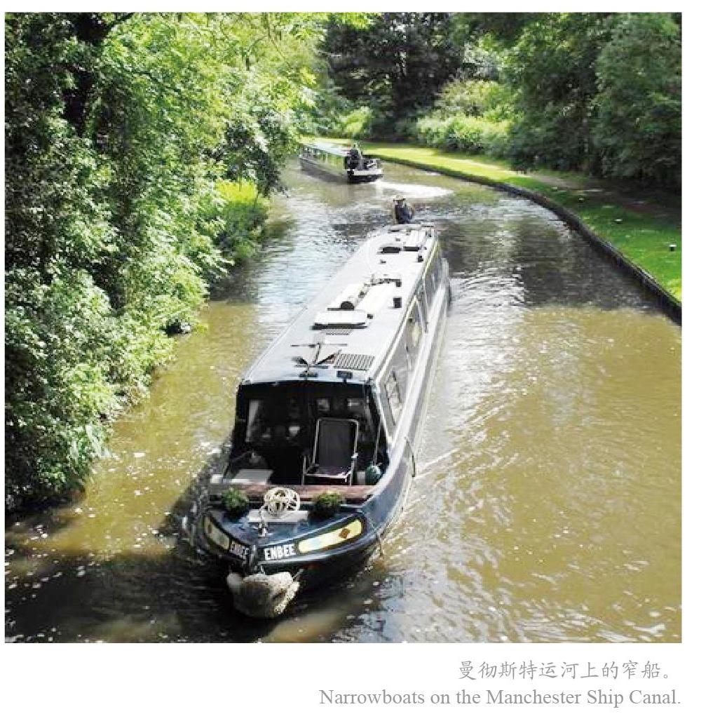
曼徹斯特运河
曼彻斯特运河是英国英格兰西北部的运河。1887年开始修凿,1894年通航。由默西河和伊尔韦尔河供水。该运河从东哈姆到曼彻斯特,长58公里,宽14至24米,深约9米,有5个船闸,使大型远洋轮可以进入曼彻斯特。
The Grand Canal in China
By Liu Fanli
The Grand Canal of China, alternatively known as the Jing (Beijing)-Hang (Hangzhou) Grand Canal or the South-North Grand Canal, was first dug in the year 486 BC. Running for over 2,700 kilometers, it consists of three parts: the Sui-Tang Grand Canal, the Jing-Hang Grand Canal and the Eastern Zhejiang (Zhedong) Canal. The canal is the worlds longest constructed waterway, and the largest and most extensive water conservancy project in ancient China.
Starting from Beijing in the north, it passes through the city of Tianjin and the provinces of Hebei, Shandong, Jiangsu and Zhejiang before ending in the city of Hangzhou in the south, connecting the Haihe River, the Yellow River, the Huaihe River, the Yangtze River and the Qiantang River. In the east, the canal reaches the East China Sea via the Eastern Zhejiang Canal. The Grand Canal was a major waterway connecting East China with the interior river system, and linking the south with the north. It also served the functions of irrigation, flood control and drainage, and has played an important role in the political, economic, military and cultural development and foreign exchanges of successive dynasties.
In 486 BC, Fu Chai (?-473 BC), king of the State of Wu (ca. 12th century-473 BC), dredged the ancient waterway passing from Suzhou to Yangzhou via Wuxi and Changzhou, to realize his military ambition of conquering the Central Plains. Meanwhile, work began on the construction of a canal, which later was known as Han Gou (literally “Han Conduit” or Han Canal), from the south of Yangzhou to the north of Huaian in Jiangsu).
Over a thousand years later, in the year 605, Emperor Yang (569-618) of the Sui dynasty (581-618) ordered the Tongji Canal to be dug. The canal, alternatively known as the Bian Canal, was the main waterway for Caoyun (tribute grain transport). He then ordered the opening of the Yongji Canal, which was able to connect with the cities of present-day Tianjin and Beijing in the north. In 610, the Jiangnan Canal was built, which started from Zhenjiang in Jiangsu, via Wuxi, Suzhou, before reaching Jiaxing and Hangzhou in Zhejiang and ultimately the Qiantang River. By then, a canal system centered around Luoyang and consisted of the Yongji Canal, the Tongji Canal, the Han Canal and the Jiangnan Canal had been in place, extending to Hangzhou in the south and Beijing in the north.
The Tang dynasty (618-907) mainly improved canal lock efficiency, apart from minor changes made to the canal to cut down on travel time, but there were no fundamental differences between the Sui Grand Canal and the Tang Grand Canal. During the Song dynasty (960-1279), a double-gate system known as the pound lock was invented, which allowed boats to pass through safely, and shipping capacity was increased as well.
To improve the Caoyun system, the Yuan (1206-1368) government started to dig the Jizhou Canal and later the Huitong Canal, which enabled Caoyun boats to reach Tongxian county near the capital Beijing. From 1291 to 1293, the Yuan government built the Tonghui Canal, linking Tongxian county directly with the center of Beijing. The general shape of the Grand Canal as we know today took shape at that time.
The Ming (1368-1644) and Qing (1616-1911) dynasties both expanded the Grand Canal. Then in 1855, heaving flooding of the Yellow River changed its course and severed the Grand Canal at Shandong province. From then on, the canal largely fell into disrepair despite calls to renovate it in late-Qing and during the Republican period (1912-1949). After the founding of the Peoples Republic of China, efforts have been continuously made to restore and expand the Grand Canal. For example, the project to expand and reconstruct the Jining-Hangzhou section has begun, which when completed will see shipping lanes further widened through dredging. At the same time, it will also facilitate traveling from the Grand Canal to the Qiantang River and expand the port handling capacity.
With a total length of 239 kilometers, the extension section of the Grand Canal into the sea, known as the Eastern Zhejiang Canal, starts from Xixing street, Binjiang district of Hangzhou in the west, crosses the Caoe River, passes through Shaoxing and ends at the mouth of Yongjiang River, Ningbo in the east. As an important link between the land-based Silk Road and the Maritime Silk Road, its history can be traced to the Ancient Shanyin Canal dug by the State of Yue (2032-222 BC) during the Spring and Autumn Period (770-476 BC). The Eastern Zhejiang Canal is one of the only two extant canals on record from the pre-Qin (before 221 BC) period, and is still the main waterway for navigation, flood discharge and irrigation in the Ningbo-Shaoxing Plains.
As the worlds longest and oldest man-made waterway, and the worlds largest and most extensive civil engineering project prior to the Industrial Revolution, the Grand Canal greatly promoted Chinas north-south exchanges, consolidated its political unification and fostered its ethnic unity, on top of the apparent transportation, economic and social benefits it had brought. The canal is a show of the Chinese peoples wisdom, determination and courage, as well as an eastern civilizations outstanding achievements in the fields of water conservancy and water management. It can be said that the Grand Canal is the result of mutual adaptation and mutual transformation between ancient Chinese people and nature that enabled their mutual success.
A major transportation artery between the north and the south, especially during the Ming and Qing periods, the Grand Canal played a significant role in Chinas cultural exchanges with foreign countries as well. Some foreign envoys, missionaries and travelers frequently took the route.
In the late 1200s, Marco Polo, one of the very first foreign travelers to introduce China to Europe, recorded many of his trips to the canal cities. Indeed, of those who later came to China, a large number followed his steps.
A Sulu King named Paduka Pahala sailed from the Philippines to Imperial China in 1417. Their 340-strong delegation arrived in Hangzhou after landing in Quanzhou, Fujian province. They then journeyed northward for two and half months along the Grand Canal before reaching Beijing. His delegation was said to have made a strong impression on the Chinese emperor, who made him the most important guest at that time. Unfortunately, he contracted some disease and died in Dezhou, Shandong province, on his way back home. He was buried at the place and a monument was built for him.
In the 16th century, the Italian Jesuit Matteo Ricci used to travel on the Grand Canal, and he seemed to be more interested in its transportation: … the Chinese appear to prefer bricks over stones, and the bricks for the imperial palace are most likely brought in on ships some 1,500 miles away, for which many ships have worked day and night …
Then in 1793, that infamous Macartney mission from the British Empire, aimed to facilitate British trade with the Qing. The British delegation boarded their ships in Tongzhou, Beijing after an audience with the emperor (Emperor Qianlong) and followed the Grand Canal for 33 days all the way to Hangzhou.
The water conservancy projects, the towns and villages along the canal as well as the local customs left a deep impression on many foreigners, which have been reflected in their works. Their observations and descriptions can undoubtedly help deepen our understanding of the Grand Canal.
One such example is Choe Pu (1454-1504), a Korean official known for his travel diary in Ming China, after he survived a shipwreck near the coast of Zhejiang. Piao Hai Lu (or A Record of Drifting Across the Sea), as his diary was titled, recorded in detail the transportation of the Grand Canal and the social customs along the way.
Another is Sakugen Shūryō (1501-1579), a Japanese Zen Buddhist monk, a poet and diplomat in the Muromachi period. He was the vice envoy and the chief envoy of the Japanese missions in 1539 and 1547 to the Chinese imperial court in Beijing. During his time in China, he has traveled multiple times along the Grand Canal, and he put his experiences into several poem collections, such as Ru Ming Ji (Record of My Journey to Ming China), which have become important documents in the history of Sino-Japanese relations.
A World of Canals
The Jing-Hang Grand Canal
One of the oldest canals, the Jing-Hang Grand Canal is the longest and largest ancient canal in the world. Together with the Great Wall and the Karez, it is known as the three great projects of ancient China.
First dug by the State of Wu (ca. 12th century-473 BC) in the Spring and Autumn Period to facilitate its attack on the State of Qi (1046-221 BC), it was greatly expanded in the Sui dynasty, extended to the capital of Luoyang and even connected to Zhuojun (present-day Beijing). In the Yuan dynasty, when the long-jammed canal was restored and rebuilt, instead of Luoyang, Beijing, capital of Yuan, was chosen as the northern point of the canal.
The Grand Canal runs from Yuhang (present-day Hangzhou) in the south to Zhuojun (present-day Beijing) in the north, passing through the provinces of Zhejiang, Jiangsu, Shandong, Hebei and the municipalities of Tianjin and Beijing. With a total length of about 1797 kilometers, it cuts across the Haihe River, the Yellow River, the Huaihe River, the Yangtze River and the Qiantang River. Throughout history, the Grand Canal has played a significant role in the economic and cultural development, especially the industrial and agricultural economic development, as well as exchanges between northern and southern China.
The extension section of the Grand Canal into the sea, known as the Eastern Zhejiang Canal, starts from Xixing street, Binjiang district of Hangzhou in the west, crosses the Caoe River, passes through Shaoxing and ends at the mouth of Yongjiang River, Ningbo in the east, with a total length of 239 kilometers. The Eastern Zhejiang Canal is one of the only two extant canals on record from the pre-Qin period, and is still the main waterway for navigation, flood discharge and irrigation in the Ningbo-Shaoxing Plains.
The Suez Canal
Officially opened in 1869, the Suez Canal is an artificial sea-level waterway running north to south across the Isthmus of Suez in Egypt to connect the Mediterranean Sea and the Red Sea. The canal provides the shortest maritime route between Europe and the lands lying around the Indian and western Pacific oceans, and it is one of the worlds busiest shipping lanes. Separating Africa from the Asian continent, the canal is one of the most important waterways for the exchanges between people in the two continents.? ?From Port Said in the north, dug into the Mediterranean Sea, to the city of Suez in the south, the canal runs a length of about 190 kilometers.
The Panama Canal
Opened in 1914, the Panama Canal an artificial waterway in Panama that cuts across the Isthmus of Panama and connects the Atlantic Ocean with the Pacific Ocean. As an important shipping conduit, the canal is one of the Seven Wonders of the Modern World. It is a lock-type canal, owned and administered by the Republic of Panama. The length of the Panama Canal from shoreline to shoreline is about 65 kilometers and from deep water in the Atlantic (more specifically, the Caribbean Sea) to deep water in the Pacific is about 82 kilometers. The wider part of the canal can reach 304 meters, while its narrowest part stands at 152 meters. The Panama Canal also divides the North America from the South America.
The Erie Canal
Completed in 1825, the Erie Canal runs for 584 kilometers, 12 meters in width and 1.2 meters in depth. With a total of 83 locks, the canal could handle barges with a maximum displacement of 75 tons. It was the first rapid transportation system between the East Coast of the United States and the western interior that did not require portage, much faster than the animal-pulled trailers most commonly used at the time. As well as making traffic faster, the canal also helped cut transportation costs between coastal areas and the interior areas by 95%. Rapid canal traffic made the western part of New York state more accessible, thus contributing to rapid population growth in the Midwest.
The Albert Canal
The Albert Canal is a canal located in northeastern Belgium, which connects the city of Liège on the Meuse River in the west with the city of Antwerp on the Scheldt River in the east. The canal runs a total length of about 130 kilometers, and was built between 1930 and 1930, with a minimum bottom width of 24 meters and a minimum depth of 5 meters. It could be navigated by 2,000-ton vessels, and has six sets of triple locks and one single lock at Monsin (Liège).
The Moscow Canal
Built between 1932 and May 1, 1937, the Moscow Canal, named the Moskva-Volga Canal until 1947, is a canal in Russia that starts from the Volga River in the town of Dubna, just upstream of the dam of the Ivankovo Reservoir and connects to Tushino (an area in the northwest of Moscow) 190 kilometers away from the mouth of the Moskva River. Crossing the oblasts (states) of Moscow and Tver, it runs 128 kilometers and is 85 meters wide, navigable for ships up to 5,000 tons. The canal has made Moscow the “port of the five seas” as it created access to five seas: the White Sea, Baltic Sea, Caspian Sea, Sea of Azov and the Black Sea. Apart from transportation and recreation, the canal provides for about half of Moscows water consumption.
The Volga-Don Canal
Connecting the lower Volga and the lower Don, before ultimately flowing into the Sea of Azov, the Volga-Don Canal is in Russias oblast (state) of Volgograd. Construction on the canal began in 1948 and officially opened in 1952. The canal starts from Kalach-na-Donu, on the eastern shore of the Tsimlyansk Reservoir, for 101 kilometers to Krasnoarmeysk on the Volga immediately south of Volgograd. There are 13 locks along its route, which drops 88 meters to the Volga and 44 meters to the Don. Three reservoirs — Karpovka, Bereslavka, and Varvarovka — lie along its path and occupy 45 kilometers of its length. The canal, which can take the largest rivercraft and smaller seagoing ships, opened up the upper Volga, Kama River, and Urals regions to oceanic commerce via the Don River.
The Kiel Canal
The Kiel Canal, also known as the North Sea-Baltic Sea Canal, is a 98-kilometer-long (53.3 nautical miles) canal in the German state of Schleswig-Holstein. The canal links the North Sea at Brunsbüttelkoog at the mouth of the Elbe River in the southwest with the Baltic Sea at Kiel-Holtenau in the northeast, cutting right across the Jutland Peninsula. The construction of the Kiel Canal saves the journey between the North Sea and the Baltic Sea by about 370 nautical miles than by going around the Jutland Peninsula. The canal was originally dug by the Germans to help the Germans warships avoid sailing around the Jutland Peninsula. Work to widen and deepen the riverbed began in 1907 and was completed in 1914, a few weeks before the outbreak of World War I, to accommodate large ships. Commercially, it is now a safe, convenient and economical waterway between the North Sea and the Baltic Sea.
The G?ta Canal
The G?ta Canal is a Swedish canal built in the early 19th century. It travels through the lakes of V?nern and V?ttern from Gothenburg on the west coast to S?derk?ping on the Baltic Sea via. The canal is 190 kilometers long, of which 87 kilometers were dug or blasted. With 58 locks, it can accommodate ships of 32 meters long and 7 meters wide with a draft of 2.8 meters.
The Manchester Ship Canal
The Manchester Ship Canal is a canal in the northwest of England. The construction of the canal began in 1887 and official navigation started in 1894. Fed by the Mersey and Irwell rivers, the canal runs from Eastham to Manchester, 58 kilometers in length, 14 to 24 meters in width and about 9 meters in depth. With five locks, the canal allows large ocean liners to enter the Manchester area.
猜你喜欢
走向世界(2022年18期)2022-05-17
金桥(2022年2期)2022-03-02
华人时刊(2022年21期)2022-02-15
金桥(2021年6期)2021-07-23
历史地理研究(2020年4期)2021-01-18
黄河之声(2020年11期)2020-07-16
小天使·一年级语数英综合(2018年9期)2018-10-16
民族音乐(2016年4期)2016-12-06
雕塑(2000年1期)2000-06-21
